Bowsherville – Pitt Township (formerly in Crawford County)
Post Office: 1837 – 1865
Location: 40.738025, -83.293223
on SR 294 at the intersection of County Hwy 115
Remnants: Bowsherville Cemetery on private property on the east side of County Highway 115 south of SR 294
Description: “Major” Anthony Bowsher (1799 – 1886) from Northumberland County, Pennsylvania and Catherine (Staley) Bowsher (1801 – 1864) got married in Pickaway County in 1819. They moved to Wyandot County later that same year along with some members of both families. After almost a decade of hard work, the Bowshers saved enough money to start up a town and built a hotel and a general store. Bowsherville was platted in 1828 with 34 lots and was the first settlement in the township. Anthony was a model frontiersman with a burly figure but distinguished look, and found an acceptable way of being a gentleman who happened to swear a lot. He never went to school and couldn’t read or write but had his own system of symbols for keeping records as a merchant. Much of it was simple drawings of what people bought on credit. Pictures of tiny pitchforks, wheels of cheese, and a wheel with a hole for grinding stones were kept in the logs. There was once a heated dispute over what one of the townspeople bought because Anthony forgot to put the hole in a wheel for a grinding stone and thought the guy bought a wheel of cheese, which the purchaser firmly denied. Laughter broke out from both parties though after the mistake was figured out. The hotel was an important stagecoach stop between Columbus and Toledo and the general store did very well selling everything imaginably needed back in the day. Local Wyandotte Natives Americans were continuous friends of the Bowsher family and were welcome to use the store as a trading post. A tavern operated by the Bowshers added to the atmosphere and a post office in the general store ran from 1837 – 1865. The known postmasters were William H. Hunt (1810 – 1861) who was laid to rest in Bowsherville Cemetery and Albert Mears (1819 – 1902)who was buried 5 miles northeast of the GPS coordinates in Oak Hill Cemetery on Co Hwy 119. Anthony’s father Peter (1782 – 1844) owned a blacksmith shop and later moved to Indiana. The town had a school, the first being in the Bowshers original log cabin, and a wood frame Methodist Episcopal Church was constructed in 1859 in the southeast corner of the town’s main intersection. Anthony also built a horse race track which drew many visitors from surrounding counties. He spent a lot of time there in summer racing, hanging out, and was the leader of a singing school in winter. Making several business trips over the years to places like Columbus, Toledo, and Perrysburg, Anthony had some famous friends including Mordecai Bartley who was the governor of Ohio from 1844 – 1846. They frequently ate dinner together with senators and other prominent figures at the Old Neil House, a popular hotel in Columbus. The Bowshers had 8 children and the town grew to around 75 residents in the 1860s. Anthony and Catherine bought a house in Carey where they intended on living many years together, but she unfortunately passed away in 1864. Anthony worked up to the late 1860s with 40 years of operating the hotel, general store, and tavern. After retiring, he still led an active life and was well thought of by locals who loved listening to his stories of the olden days. Anthony “courted” several widows in his declining years while carrying around a cane with calico tassels hanging off the top representing every one of them. He passed away in Harpster while staying with the Harpster family. It’s unknown where Anthony and Catherine were buried, but we suspect they were probably laid to rest somewhere around Carey. Bowsherville’s last appearance on a map was in the 1868 Atlas of the State of Ohio. With the hotel and general store closed, and the railroads passing by in larger towns, the stagecoach era was over and Bowsherville went away with it. Some residents, including 5 known interments of the Bowsher family, were buried in Bowsherville Cemetery in a field on private property on the east side of County Hwy 115 between County Rd 71 and SR 294. In the abundant research we’ve done over the years, the adventures and tales of Anthony Bowsher have only been rivaled by a couple of other interesting characters. Aside from what’s in this listing, much more can be read about him in the 1884 History of Wyandot County, Ohio and the 1913 Past and Present of Wyandot County, Ohio. No one knows exactly when the honorary title of “major” was bestowed upon Anthony, but it’s no wonder why.
Thanks to Gary Pack for providing the location info on Bowsherville!
Crane Town (Cranetown) (Tarhetown) – Crane Township
Location: 40.895391, -83.243490
on T-37 (Co Hwy 37) between SR 67 (Tarhe Trail) and Everhart Rd along the Sandusky River
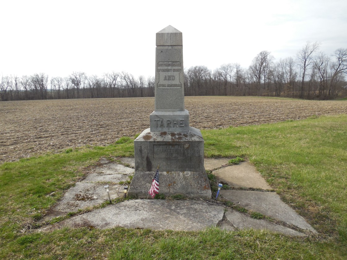
Remnants: Chief Tarhe Monument at the GPS coordinates, Indian Mill 2 1/2 miles southwest of the GPS coordinates on C-50 (Co Hwy 50) at the intersection of C-47
Description: This Native American Wyandotte village was founded by the Porcupine Tribe in the late 1700s and was named after Chief Tarhe (1742 – 1818). His nickname was “The Crane” for being well over six feet tall and having long arms. As with most Native Americans, Chief Tarhe rightfully fought against American expansion in the 1700s, but sided with the Americans against the British during the War of 1812. After Chief Tarhe’s death, the residents moved to Upper Sandusky which was their primary village in Ohio during the late 1700s and throughout the Revolutionary War. A grist mill and saw mill was constructed between the two sites by the U.S. Government in return for the Wyandotte’s assistance in the War of 1812. The Wyandottes were forced to move in 1842 in accordance with the Indian Removal Act of 1830 and ended up in what is now Wyandotte, Kansas. The current City of Upper Sandusky was platted in 1843 and the present Indian Mill at the location of the original one was built in 1861. It was restored and opened to the public as a milling museum in 1968. The Tarhe Monument was constructed by Tarhe Tribe No. 145 in 1915 and is beautifully engraved in honor of his memory.
Douglass (Douglas) – Crane Township
Location: 40.822574, -83.222289
on Township Hwy 124 B at the railroad crossing between Wyandot County Hwy 182 and T-55 along Rock Run
Remnants: Bethel Church and Rock Run Cemetery on the west side of Township Hwy 124 B just south of the GPS coordinates, Old Rock Run (Hass) Cemetery about 1/2 of a mile northwest of the GPS coordintes on the north side of Wyandot County Hwy 182, old houses and farm buildings in the area
Description: Douglass was on the northwest branch of the Pennsylvania Railroad (formerly the Pittsburgh, Ft. Wayne, & Chicago Railroad) in the late 1800s to early 1900s, but it didn’t have a train station. A school (Crane Township No. 4) was 3/4 of a mile north of the GPS coordinates on the east side of Township Hwy 124 B. There was a Church of God in the northeast corner of the intersection of Township Hwy 124 B and Wyandot County Hwy 182. Its congregation formed in 1847. The wood frame structure was built in 1860 at a cost of $1500. It was renovated in 1883 and has since been lost to time. We couldn’t find a building date for Bethel Church, but the brick structure is old and appears to be in excellent condition. Its congregation is still active.
Germantown – Antrim Township (formerly Dallas Township, Crawford County)
Location: 40.723222, -83.186261
on US 23 at the intersection of T-72 (Township Hwy 72) along Honey Run
Remnants: none known
Description: It was founded by settlers of German and Swiss descent, including Jacob, Adam, and John Coon, Valentine Mutchler, John Heckathorn, and Jacob Snyder. They arrived from Pickaway County in 1819. The attempt of making a permanent town didn’t work out. The Coons lived in Virginia before relocating to Ohio. Jacob Coon (1799 – 1881) and Susannah (Harmon) Coon (1810 – 1871) got married in 1831, had at least 7 children, and owned an 80-acre farm at the GPS coordinates. They were buried with relatives in Little Sandusky Cemetery 2 miles northwest of the GPS coordinates on the south side of SR 294. Adam Coon (1804 – 1878) married Elizabeth (Heckathorn) Coon (1807 – 1886) in 1826. They settled in Sycamore Township (formerly in Crawford Township, Crawford County) in 1828, had 10 children, and were laid to rest with relatives in Belle Vernon Cemetery on the east side of SR 67 (Tarhe Trail) in Tymochtee Township. Valentine Mutchler (1795 – 1858) from New Jersey married Catherine (or Catharine) (Coon) Mutchler (1797 – 1836) in 1816. They had 9 children. Catherine was buried with relatives in Seery (Olive Branch) Cemetery on Orr Rd (Township Hwy 26) in Lykens Township, Crawford County. The Coon and Seery families were related by marriage. Valentine remarried in 1837, had 11 more children, & was buried with relatives in Deer Creek Cemetery on Grand Blvd in Lake County, Indiana. John H. Heckathorn (1781 – 1853) from Frederick County, Virginia married Dorthea (Shambaugh) Heckathorn from Montgomery County, Pennsylvania in 1804. They had a few children and were interred in Tymochtee (Shriver) Cemetery on the east side of T-94 in Marseilles Township. Jacob Snyder (1804 – 1847) married Phebe Ann Snyder (1807 – 1866) and they were laid to rest in Chandler Cemetery on the west side of SR 67 in Marseilles Township.
Halifax – Antrim Township (formerly Dallas Township, Crawford County)
Location: unknown
Description: Halifax was listed as being recently platted in The Ohio Gazetteer and Traveler’s Guide from 1837 – 1841. The town’s land, containing 20 lots, was owned by the state when Wyandot County was formed in 1845 which suggests the former plat owner failed to pay off the land debt or taxes.
North Tymochtee – Tymochtee Township (formerly in Crawford Township, Crawford County)
Location: unknown
Description: The only info on the town is the names of lot owners in when Wyandot County was formed, listed in the 1884 county history book. They were William Smith, Joseph T. Terry, Charles L. Boalt, Daniel McCahan, George T. Frees, and the state owned one or more lots. Joseph T. Terry (born c. 1792) was from Massachusetts. His wife’s name was Elizabeth and she was from New York. They were last recorded as living in the township in the 1850 census and had 7 children at the time. Charles L. Boalt (1802 – 1870) from Fairfield County, Connecticut married Eliza (Girswold) Boalt (1799 – 1878) from New London County, Connecticut. They had a few children and were laid to rest with relatives in Woodlawn Cemetery on Woodlawn Ave in Norwalk, Huron County. George T. Frees (1810 – 1864) was a Freemason and was interred in Mission (Old Mission) Cemetery at the intersection of N 5th St and E Church St in Upper Sandusky.
Peru (Perue) – Tymochtee Township (formerly in Crawford Township, Crawford County)
Location: unknown
Description: As with North Tymochtee, the only info on the town is the names of the lot owners at the time the county was formed, listed in the 1884 county history book. They were Ezekiel Ekleberry, Jesse Morgan, John Clinger, Daniel Terflinger, and the state owned one or more lots. Ezekiel Ekleberry (1795 – 1869) from Pennsylvania married Mary Ann (Trowbridge) Ekleberry (1795 – 1862) and had at least 7 children. They were buried with relatives in Bibler Cemetery on the north side of Co Hwy 16 just east of the intersection of C-35 (Co Hwy 35). Jesse Morgan (1808 – 1872) from Virginia married Christina (Bretz) Morgan (1808 – 1872) and had at least 4 children. They moved out of the state and were buried with relatives in Washington Chapel Cemetery on at the intersection of W Bennington Rd and Ford Rd in Black Hawk County, Iowa. John Clinger (1803 – 1880) from Dauphin County, Pennsylvania married Barbara (Cochenour) Clinger (1805 – 1888) from Virginia. They had a few children and were laid to rest with relatives in Henrickson Cemetery at the intersection of SR 67 (Main St) and T-108 (Township Hwy 108) in Mifflin Township. Daniel Terflinger (1803 – 1851) married Elizabeth (Wininger) Terflinger (1808 – 1896) and had at least 10 children. They were interred with relatives in Lutheran (Old Lutheran) Cemetery on Cass St in McCuthenville. Neither North Tymochtee nor Peru were pinpointed in the 1879 county atlas or on the Ohio map in the 1901 George Cram atlas. However, they were later mentioned in the 1913 Past and Present of Wyandot County, Ohio which stated they were still towns and possibly had a general store and a church.
Pleasant Dale – Jackson Township (formerly in Hardin County)
Post Office: 1839 – 1850
Location: unknown
Description: David H. Warner (b. 1802) from Connecticut was the first known postmaster when the office was in Jackson Township, Hardin County. His wife’s name was Mary (born c. 1819) from Maryland. They had at least 3 children an their burial location is unknown. David was succeeded as postmaster by Thomas Scott (1809 – 1852) from Delaware when the post office moved to Jackson Township, Wyandot County. David married Mary (Hannah) Scott (1808 – 1851) and had at least 5 children. They were buried with relatives in Jackson Center Cemetery at the intersection of SR 37 and T-86 (Township Hwy 86) in Jackson Township, Wyandot County.
Ridgeville – Ridge Township (formerly in Amanda Township, Hancock County)
Location: 40.989792, -83.456251
on SR 568 between C-3 (Co Rd 3) and 89A (Township Hwy 89A)
Remnants: Hickory Grove Cemetery 1 mile north of the GPS coordinates on the north side of Co Rd 264 in Biglick Township, Hancock County
Description: Ridgeville was originally platted in Hancock County with 24 lots in 1836 by Lemuel Roberts (1798 – 1863) and Elizabeth (Wilson) Roberts (1797 – 1861). Eli Ragon opened a general store but only 6 lots in Ridgeville sold and the idea of turning the place into a successful town was abandoned prior to 1850. Lemuel and Elizabeth had a few children and were buried with relatives in Hickory Grove Cemetery.
Ruskin – Marseilles Township
Post Office: 1900 – 1903
Location: 40.723600, -83.343151
on C-71 (Co Hwy 71) at the intersection of T-123
Remnants: none known
Description: Ruskin was a small farming and postal town with a grocery store. Charles J. Baumunk (1874 – 1901) was the first known postmaster. He was buried with relatives about 10 miles northeast of the GPS coordinates in Saint Peters Catholic Cemetery on N 8th St in Upper Sandusky. The last known postmaster was listed as George McC. Palmer in the 1903 Official Register of the United States – Vol. 2.