
West Jefferson, OH (Jefferson) – (1830 – present farming, mill, and railroad town that acquired most of New Hampton’s residents)
Classification: small town
Location: Jefferson Township, Madison County – on US 40 west of Columbus
GPS coordinates: 39.944811, -83.268887
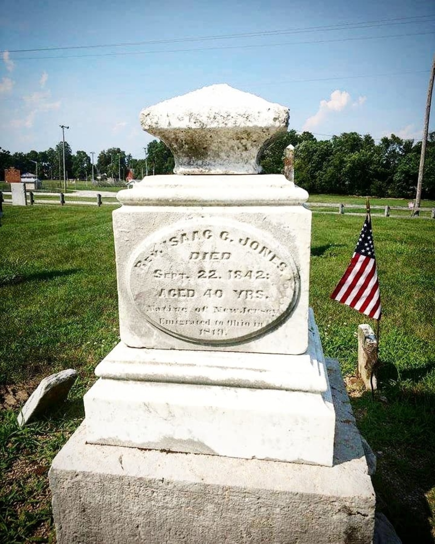
West Jefferson rose out of the dust of a failed town and was once the most important business point in Madison County. Residents needed a commercial center in Jefferson Township closer to home than the 15 – 20 mile journey to Columbus, called Franklinton at the time. Samuel Jones and Samuel Sexton moved to the area from New Jersey and platted New Hampton on July 5, 1822 along Little Darby Creek and Ludlow’s Road, the first state road in Ohio.
The town was laid out with 93 lots on 8 streets on the south side of Hampton Cemetery on Frey Ave in West Jefferson. It had 2 general stores, a post office, 3 taverns, a hotel, and a brick Baptist church at the cemetery. The lot for the cemetery was donated by Samuel Jones in 1823. His wife Elizabeth was the first burial there later that same year. Samuel Sexton’s wife Sarah and daughter Elizabeth followed in 1827.
New Hampton unfortunately wasn’t growing fast enough in the late 1820s. New of the National Road, current day US 40, being constructed to the north spelled the end for the town. It was the first federally funded highway in the county, and when completed, connected Cumberland, Maryland to Vandalia, Illinois. Samuel Jones and Samuel Sexton moved back to New Jersey, leaving behind many departed family members and the dreams of creating a successful village. At least part of that same dream lived on through the efforts of a son and daughter-in-law of Samuel and Elizabeth Jones.
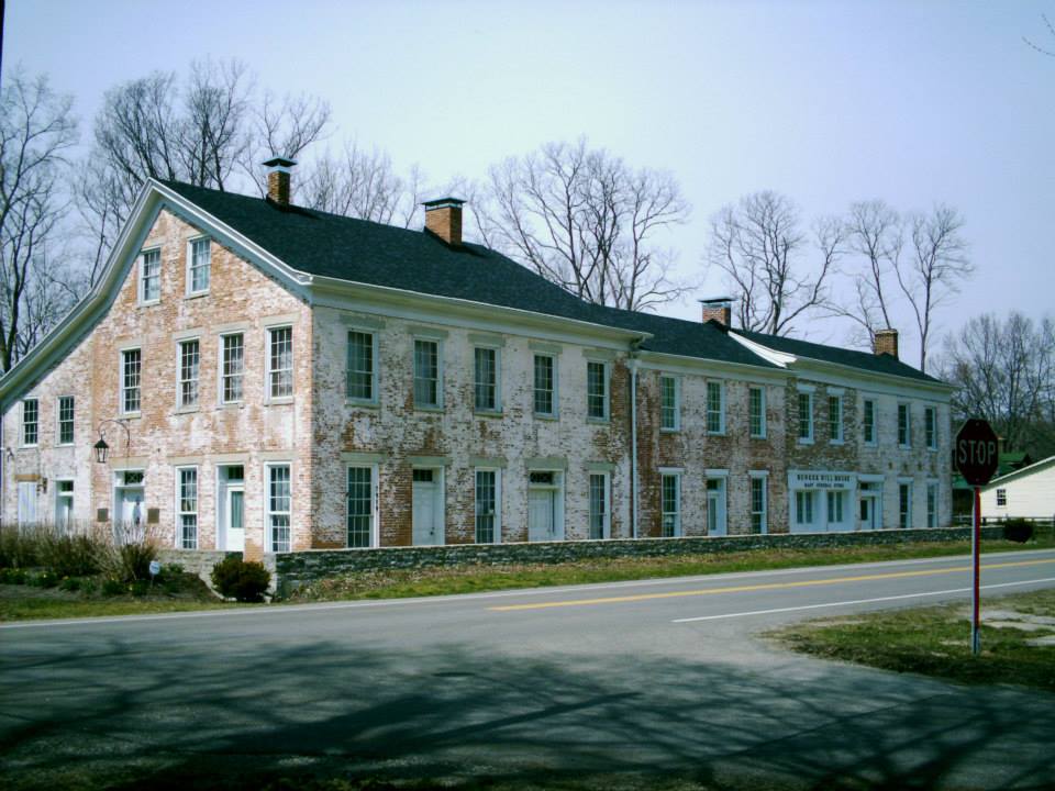
Reverend Isaac Jones (1802 – 1842) and Eliza (Mills) Jones (1804 – 1877) inherited some of Isaac’s parents land along the National Road on November 17, 1830. They founded Jefferson and platted the town in September of 1831 with 64 lots. Its post office opened in 1833 but was called West Jefferson to avoid confusion with other towns in Ohio named Jefferson. By 1834 the town already had 700 citizens. Business boomed along the National Road and in West Jefferson in the 1840s and 1850s. Lumber mills and merchant shops fueled the local economy on top of farming and livestock raising.
On the northwest side of town, War of 1812 veteran John Blair (1788 – 1870) from Virginia and Jency (Jennie Thompson) Blair settled in the township in 1843. They were married in 1814 while John was running a hat business in London, OH and had 7 children. Their oldest child, George W. Blair (1817 – 1886) married Rachel (Goodson) Blair (1820 – 1883). They had 10 children and lived on George’s parents old 300-acre farm. George and Rachel welcomed a Methodist congregation into their home for services for 9 years until donating land for a church and cemetery. Blair Chapel was constructed in 1853 with $700 in funds raised for the structure. The church has since been lost to time.
On top of owning and operating the first steam-powered thresher and reaping machine in the county, George managed construction of 3 miles of Blair Pike in 1868 – 1870. The road still bears the family name along with a branch of the Taylor family that later settled in the area. John, Jency, George and Rachel were buried with relatives in Blair Cemetery on Taylor Blair Rd. The road also had 3 steam-powered saw mills and a water-powered saw mill on Little Darby Creek in the mid to late 1800s.
Back in town, West Jefferson was flourishing with a grist mill and pork packing industry. It had 5 hotels at its peak with passenger and goods stagecoaches lining the streets. Sebastian Roberts (1814 – 1869) and Tacy (Holt) Roberts (1821 – 1889) donated land for Pleasant Hill Cemetery on US 40 in 1864. Sebastian’s parents, Thomas and Susan, formerly owned most of the land on the west side of town and were the first burial there in 1864. A two-story high school was built in 1868 at a cost of $17,000 including the grounds and furniture. Everything was going great until the Little Miami River arrived in town.
Railroads were usually a blessing for town in the mid to late 1800s, but it initially hurt businesses on the National Road and in West Jefferson. Goods shipped in on trains were cheaper than those made locally, but a wool mill and carriage factory kept the town going. In 1883 the town population was around 800 and there was only one hotel remaining. Residents adapted to the changing times though and business picked up again with the addition of the Murray Lumber Company in 1890.
A town hall and an opera house that could entertain 600 residents were constructed in 1898 and a new high school was built in 1911 at the intersection of Frey Ave and Fellows Ave. The Pennsylvania Railroad bought out the Little Miami and raised the tracks through town in 1913 – 1914 to prevent traffic accidents. Its last passenger station is on N Walnut St south of the railroad underpass. The town population was 1,070 in 1915 with street lights and businesses illuminated by natural gas piped in from Columbus. A junior high school was later attached to the high school and both were demolished in 2007. Isaac and Eliza Jones were buried in Hampton Cemetery.
West Jefferson’s current population is around 4,300. Since 1951, the town conducts an annual West Jefferson Ox Roast during Labor Day Weekend. 5,000 pounds of meat are lovingly prepared by volunteers and cooked in a 140 foot long, 4 feet wide by 4 feet deep pit. Streets are closed for a parade and they also run talent contests and other events. A market place is set up for craft and commercial vendors, and more food stands.
Ox Roast Info – http://www.westjeffoxroast.org/index.html
Thanks to group member Ashley Murray, manager of Around West Jefferson Ohio, for providing the listing lead, pic, and some of the info on West Jefferson!
Blackfork, OH – (1818 – present farming, clay mining, and brickyard town nearly abandoned and later repopulated)
Classification: small town
Location: Jefferson Township, Jackson County and Washington Township, Lawrence County – On SR 93 at the intersection of Blackfork Rd
GPS coordinates: 38.846793, -82.597996
The town was settled next to Black Fork Creek by a mix of runaway slaves from the south, native Americans, and European immigrants. They were all paid the same wages by local businesses during a time when racial prejudices were still running rampant in most of the rest of the country. The Union Baptist Church was organized in 1819. It was originally a log cabin structure but was replaced in the late 1800’s.
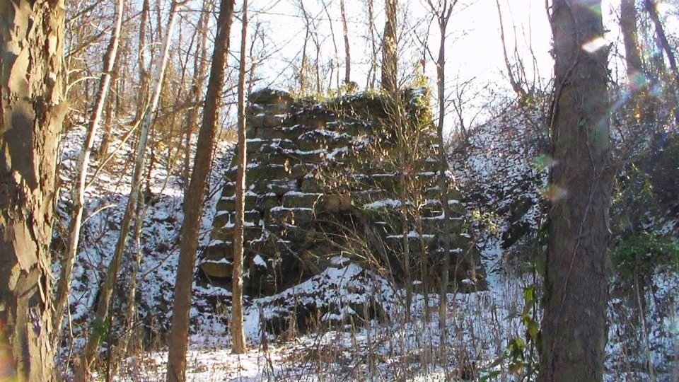
Blackfork’s first biggest sources of income were the Blackfork Coal Co. and its iron furnaces. Washington Furnace was built in the early 1850s. It was in operation from 1853 until the late 1800s and what’s left of it can be found in the woods off a gravel road on the south side of the intersection of Blackfork – Firebrick Rd and Irish Hollow Rd. The other furnace called Cambria was built in 1854. Its remains are inaccessible on private property. The land where the coal mines were got sold to the Cambria Clay Products Company who dealt in clay mining and had a brick making plant. The brickyard also had a freight station on the Toledo, Cincinnati, & St. Louis Railroad.
Portions of the old railroad platforms remain in the area and the railroad’s tunnel # 2, constructed in 1882, is about 4 miles south of town under an overpass on Dry Ridge Rd. It was constructed by the residents of Blackfork. The railroad was later bought out by the Cincinnati, Hamilton, & Dayton Railroad, and then sold to the B&O who reconstructed the tunnel in 1916. That line of tracks was abandoned the following year. It was replaced by the Detroit, Toledo, & Ironton Railroad which was in operation from 1905 – 1983. Henry Ford bought it in 1920 and had new tracks built that ran through town for hauling pig iron to Detroit.
Many resident left to find work in other town when the brick company went out of business in the early 1960s and trains ceased operations in the early 1970s. The foundation of the Cambria Company general store is still visible and marked by a set of steps next to Blackfork – Firebrick Rd. Residents were buried several cemeteries including Washington Furnace Cemetery further south down the gravel road past the furnace, Union Baptist Church Cemetery on Ninner Hill, and Bethel Cemetery on Gallia – Blackfork Rd. The town’s post office ran from 1902 – 1985.
Thanks to Donna Dickerson for providing info on the more modern railroad in Blackfork! We previously only had info on the town’s early tracks. Her dad knew most of the Detroit, Toledo, & Ironton engineers and firemen and occasionally took her with him to check it out. The trains also did pick-ups from the plant at Pedro and would ride up to the clay mill to drop entity cars and take the full cars away.
Hartsgrove, OH – (1830 – present farming and merchant town with less residents than in the past)
Classification: small town
Location: Hartsgrove Township, Ashtabula County – At the intersection of US 6 and SR 534
GPS coordinates: 41.605736, -80.953211
Hartsgrove is more of a historical community than a ghost town, but aside from the cars rolling by, being in the town square feels more like the early 1900s than the early 2000s. The township is also called Hartsgrove but was originally Gladding Township. In 1806, John Gladding (1782 – 1853) and his wife Mary (Ritter) Gladding (1783 – 1853) came from Hartford, Connecticut and settled a farm along SR 534 between Hartsgrove and Windsor. Their son Joseph Gladding (1809 – 1866) and his wife Thankful (Norris) Gladding (1798 – 1878) later settled a few miles north near Hartsgrove and had several children. Half of the township was a wedding gift to one of their descendants, and sometime in the mid to late 1800s the township name was changed from Gladding to Hartsgrove.
The town was organized in 1830 and its post office ran from 1830 – 1905. Its square has a restored general store, the last one room schoolhouse, an old church, former meeting hall, and the Hartsgrove Emporium which housed a US presidents museum. There’s also a nice small park with a gazebo in the middle of the traffic roundabout in the town square. John and Mary Gladding were buried in Windsor Township Cemetery about 5 miles south of Hartsgrove on SR 534. Joseph and Thankful Gladding were buried with several of their ancestors in Hartsgrove Center Cemetery (Hartsgrove Township Cemetery) off of SR 534 just north of the town.

Higginsport, OH (White Haven) – (1816 – present farming, mill, and river town with less residents than in the past)
Classification: small town
Location: Lewis Township, Brown County – On US 52 at the intersection of SR 221
GPS coordinates: 38.790030, -83.966255
Higginsport was basically platted on top of what was already a ghost town. In 1804 Revolutionary War veteran Colonel Robert Higgins (1746 – 1825) from Pennsylvania settled next to the Ohio River near mouth of Red Oak Creek with his wife Mary (Jolliffe) Higgins(1763 – 1806). Robert platted a village called White Haven and offered incentives to new settlers. Only a few families took him up on the offer though. The would be town was scratched and Robert tried again, platting Higginsport in 1816 with 114 lots, a public square, and the town named after his family.
There were about a half dozen log cabins in 1828 and Higginsport got its first store that same year, followed by several more stores and a post office in 1829. The first brick house in town was built in 1835 at the corner of Water St and Brown St. A brick constructed in 1842 replaced the earlier stone and log cabin chapels. One of the main sources of income for locals was farming corn and tobacco. White Burley tobacco was named after the color of the plants and is know to have been grown in the area before 1850. A steam-powered grist mill was built in 1855 by Henry Davidson and William Dugan. They added a whiskey distillery in 1861 and a warehouse in 1863.
The 1880s was probably Higginsport’s heyday with a population of around 850. The town had a couple dozen small businesses including general, dry goods, clothing, and grocery stores, 2 tin shops, 2 drug stores, a hardware store, and tobacco store. There was also a blacksmith, doctor, 17 tobacco warehouses at the peak of production, and several churches over the decades. A large school was constructed on Gaines St in 1880. One of the last major businesses in Higginsport was a steam-powered saw mill built by Boyd & Co. of Levanna in 1887. The town never had a railroad and didn’t get any big businesses in the 1900s to create another population boom.
These days, Higginsport has around 250 residents, and the number is likely to decline in the future. Most of the original streets remain intact with older buildings scattered around. An abandoned bridge crosses Red Oak Creek between SR 221 and Old A and P Rd. It was built with steel made by the Carnegie Steel Co. who’s owner Andrew Carnegie was once one of the richest people in the world. Robert and Mary Higgins are buried with some of their family members and other early settlers in Higginsport Cemetery north of town on SR 221. The school closed in 1987. It’s one of the photographed and popular abandoned schools in the state.
Murray City, OH – (1873 – present coal mining and railroad town slowly abandoned over time)
Classification: small town
Location: Ward Township, Hocking County – On SR 78 at the intersection of SR 216
GPS coordinates: 39.512331, -82.164131
It was named after John Murray Brown (1839 – 1893), an early settler who bought up the land and laid out the town in 1873. He also built a hotel in 1875 for local workers but sold out his interests in the community a few years later to a larger coal company. Brown moved to Somerset, OH, then Columbus, and later Detroit, MI where he died and was buried in Woodmere Cemetery.
Murray City was incorporated in 1891 and was once one of the largest coal towns in the country with over 2,000 residents. It had a semi-pro football team in the 1920s, the Murray City Tigers, which is now in the Pro Football Hall Of Fame. The town continues to lose more residents since the mines shut down with a current population of around 450. Its former train depot has been converted into a museum.
Thanks to group member Tammy Altman for providing the info on John Murray Brown!
Stonelick, OH – (early 1800s – present farming and mill town with little growth)
Classification: small town
Location: Stonelick Township, Clermont County – On Stonelick – Williams Corner Rd at the intersection of Balzhiser Rd
GPS coordinates: 39.128606, -84.186482
The area was settled in 1803 by Henry Allison (1739 – 1826) and Hannah (Jackson) Allison (1756 – 1837). Henry was the brother of Dr. Richard Allison, a Revolutionary War veteran who first settled the nearby town of Boston, now called Owensville. Henry built a mill on Stonelick Creek which was Clermont County’s most powerful interior waterway. It quickly grew to have the most mills in the county. There was also a large number of whiskey distilleries in the area.
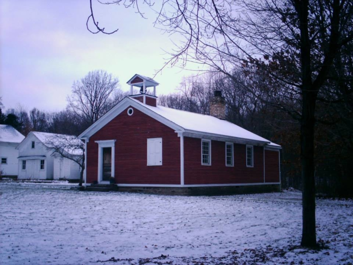
In 1839 the first Catholic congregation in the county was organized where St. Philomena church now stands on Balzhiser Rd, just off of Stonelick – Williams Corner Rd. The current church was built in 1905 on the same spot as the previous ones, a log cabin that burnt down and then a stone church. Stonelick also had few schools over the years, blacksmiths, and several cooperage shops for making barrels for whiskey storage and transportation. The post office ran from 1859 – 1900 and was in the southwest corner of the intersection of US 50 and SR 222.
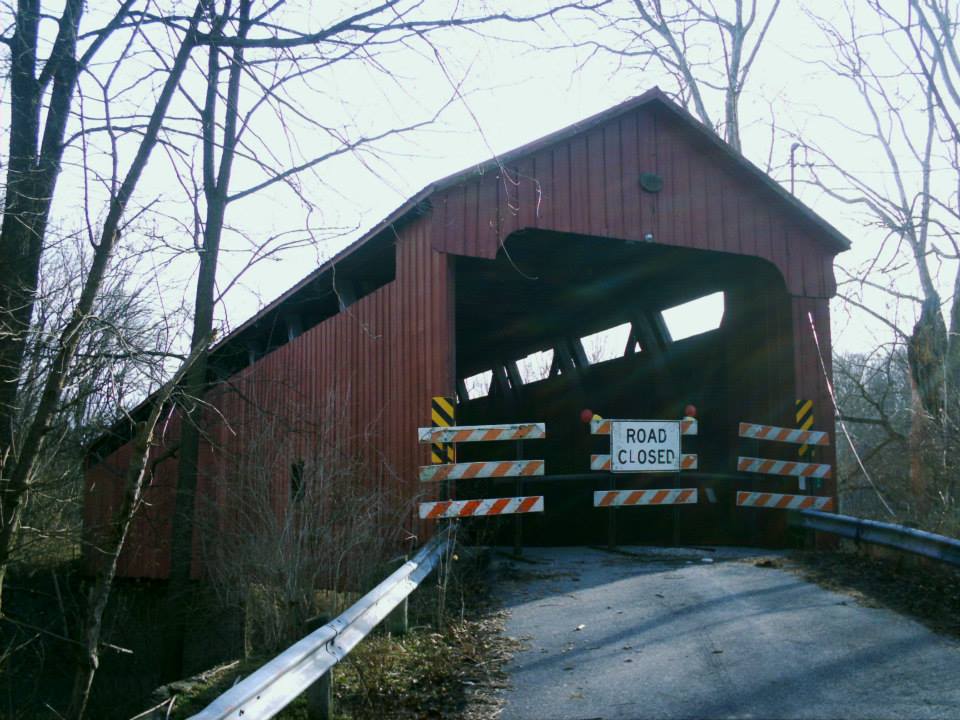
Stonelick Covered Bridge was built on Stonelick – Williams Corner Rd in 1878 and was Clermont County’s last remaining historic covered bridge. It crashed into Stonelick Creek in 2014 during efforts to restore it after being closed from traffic for several years. The rebuilding of the bridge is now complete, but it’s not nearly as historic as it once was. Local urban legends surrounded the old bridge in mystery for decades. However, there’s no records or confirmation of anything unusual ever happening there or any reasons for the bridge to be haunted.
There’s also the St. Philomena Bridge on Stonelick – Williams Corner Rd where it crosses Stonelick Creek to the corner of Balzhiser Rd next to the church. It was built in 1904 by the Champion Bridge Co. and moved to that spot in 1950 when it replaced an old covered bridge. It hasn’t been used since 2002 when a modern concrete and steel bridge was built next to it. The last schoolhouse in town, built in 1898, still sits on US 50 east of the SR 222 intersection.

Bear’s Mill, OH – (1832 – present mill town with less residents than in the past)
Classification: small town
Location: Adams Township, Darke County – On County Hwy 34 (Arcanum Bears Mill Rd) south of US 36
GPS coordinates: 40.106795, -84.541881
Bear’s Mill was settled by Major George Adams (1767 – 1832) who was a veteran of the Revolutionary War and the War of 1812. The township was named after him and George had a saw mill and corn cracker built on the land in 1832 but died later that year. In 1848 a new mill was built on the same spot by a local contractor, Manning Hart (1821 – 1891. He sold it in 1849 to Gabriel Baer (1791 – 1859). Gabriel finished the new mill including the wood siding that still lines the outside today.
It’s unknown when or why the name was changed to Bear but it’s is the oldest industrial business in Darke County. The mill store sells several kinds of flour and pottery. The address is 6450 County Hwy 34, Greenville, OH 45331 – phone # 937-548-5112. The town of Bear’s Mill was once home to scores of residents who worked in and around the mill. It’s still a populated area but the residences are more spread out now and most of the big old farms are gone.
Mill Website – http://www.bearsmill.org/
Haydenville, OH (1852 – present mining and company store town, the last company town in Ohio)
Classification: small town
Location: Green Township, Hocking County – On Haydenville Rd off of US 33
GPS coordinates: 39.480671, -82.327381
Peter Hayden (1806 – 1888) was a businessman from New York who recently moved to Columbus. He immediately set out to build his fortune in Ohio with the booming industries of the mid-1800s. Peter founded the town of Haydenville in 1852 with big plans for its future. He had an iron furnace moved from Hanging Rock, OH by canal to Haydenville in 1856. The Haydenville Railroad Tunnel was also built that same year and is said to be haunted by some of the workers who died during its construction. It can be found on a trail that goes north out of the cemetery on Howard Rd. Unfortunately a collapse inside the tunnel has rendered it unsafe to explore.
The Hocking Canal provided easy access into town, but when Haydenville got a train station on the Hocking Valley & Toledo Railroad, things began to move much faster. Peter Hayden also ran a foundry, bank, hardware store, and the company store. The train station was built in 1903 and currently sits abandoned on the tracks near Wandling Rd. The townspeople constructed a Methodist Church and a post office in 1870, a school, and also built most of their own houses. Hiring an outside contractor rarely happened.
The Haydenville Mining and Manufacturing Company was formed in 1882, engaging in brick and tile making. The town’s other main sources of income were the iron furnace and nearby clay, iron, and coal mines. The people who lived there basically worked for the town, purchased what they could from the company store, and didn’t get much more out of it than that. They also took a certain earned pride in it all though, being part of a community that made the town their own.
Haydenville and its industries were hit hard by the Great Depression. The railroad tunnel was abandoned in 1957 and the company went out of business in 1965, giving Haydenville the distinction of being Ohio’s last company town. Haydenville’s historic district was listed on the National Register of Historic Places in 1973. Ohio Historical Marker #4 – 37 at 1635 Haydenville Rd tells much of the town’s story. Many of the early residents were buried in Haydenville Cemetery on Howard Rd.
Fairhaven, OH – (early 1800s – present farming and stagecoach stop town with no growth)
Classification: small town
Location: Israel Township, Preble County – On SR 177 at the intersection of Israel – Somers Rd
GPS coordinates: 39.638649, -84.771937
Fairhaven became a town sometime around 1833 when its post office was established. Construction of the Bunker Hill House on SR 177 took place from 1834 – 1838. It was a stagecoach stop on the Hamilton, Fairhaven, & Richmond Turnpike. The massive building served as a hotel and had a tavern until 1858 when a railroad was built through Camden which took travelers past Fairhaven. In 1862 the Bunker Hill House expanded again with a general store.
Local resident Gabriel Smith was a member of the Friends Of Freedom Society and helped runaway slaves escape from the south during the Civil War. He lived at the Bunker Hill House for a while and hid slaves in his room under a stairway next to the servants quarters. Gabriel was reportedly buried in Fairhaven Cemetery on Israel – Somers Rd. The Bunker Hill House was listed on the National Register of Historic Places in 2001 and is described by Ohio Historical Marker #3 – 68 in its side yard.
The general store closed in the early 1900s and the town lost its post office in 1932. There are also several other old buildings and residences in the area. Harshman Covered Bridge was built in 1894 on Concord – Fairhaven Rd about 4 miles north of town. Its 109 feet long and spans Four Mile Creek. Fairhaven’s population was 273 in 1895. It’s probably smaller than that today and wasn’t included in the 2010 census.
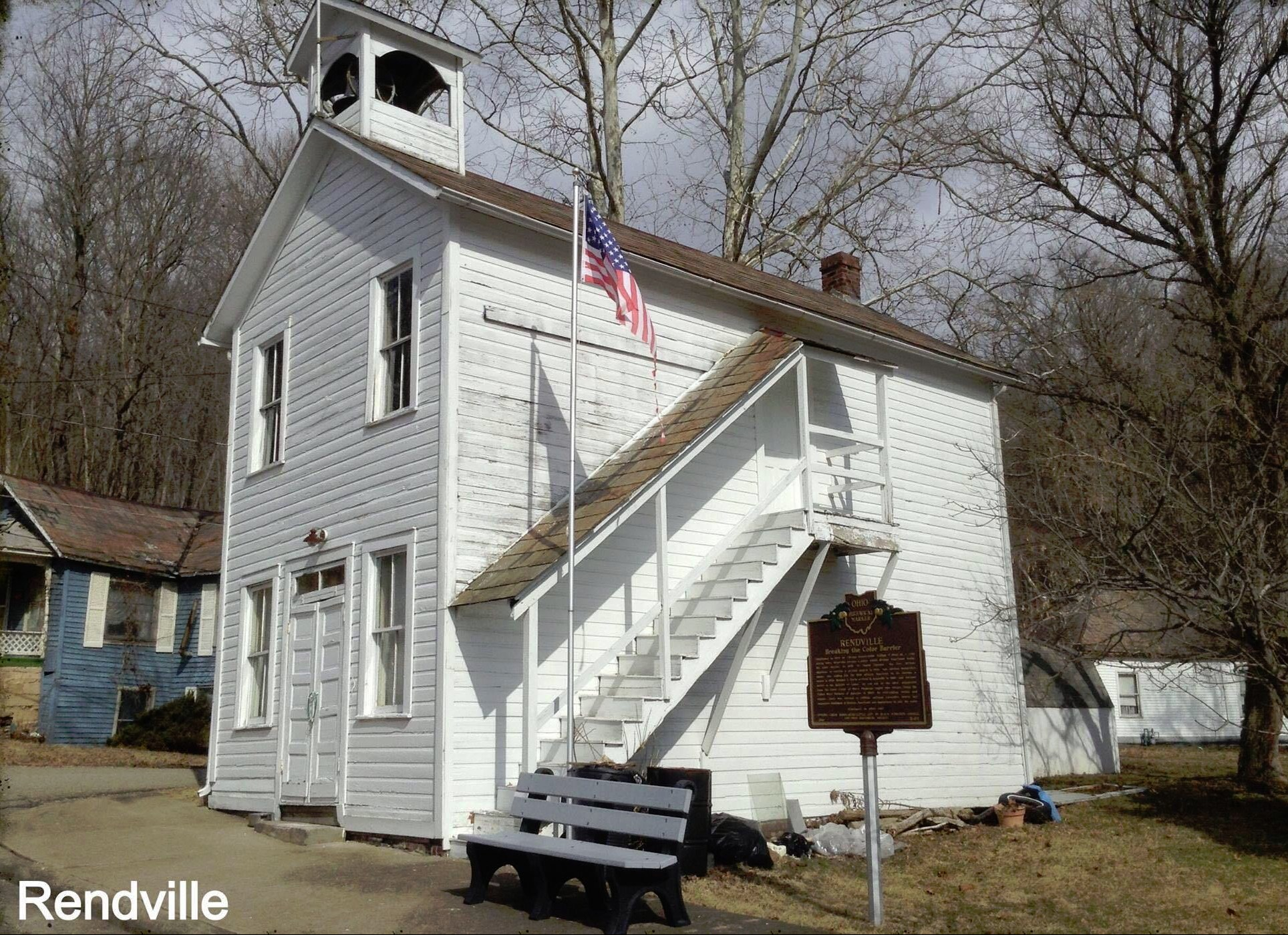
Rendville, OH – (1879 – present coal mining and railroad town mostly abandoned during the Great Depression)
Classification: small town
Location: Monroe Township, Perry County – On SR 13 at the intersection of Valley St
GPS coordinates: 39.619773, -82.090301
It’s currently Ohio’s smallest town with 36 residents in the 2010 census. Rendville was established in 1879 by William P. Rend (1840 – 1915), a Civil war veteran who later moved to Chicago and turned into a railroad, coal, and oil tycoon. William built whatever his employees needed including grocery stores, saloons, and hotels. The town had around 1,000 residents at its peak in the 1880s. Rendville was hit hard by the Great Depression and has been losing residents since then. The town lost its post office in the early 1980s. Many early settlers are buried in Rendville Cemetery at the end of Main St off of SR 13.
Thanks to group member Brett Taylor, manager of Ohio Hiking Trails and Historical Sites, for providing the listing picture! Thanks also to group member Tammy Altman for providing the info on William P. Rend!
One-Time
Monthly
Yearly
Make a one-time donation
Make a monthly donation
Make a yearly donation
Choose an amount
$5.00
$15.00
$100.00
$5.00
$15.00
$100.00
$5.00
$15.00
$100.00
Or enter a custom amount
$
Your contribution is appreciated.
Your contribution is appreciated.
Your contribution is appreciated.
DonateDonate monthlyDonate yearly