
Moonville, OH – (1856 – 1947 coal mining and railroad town abandoned when mines shut down)
Classification: ghost town
Location: Brown Township, Vinton County – In Zaleski State Forest along the old railroad path that crosses Hope – Moonville Rd
GPS Coordinates: 39.308443, -82.324566
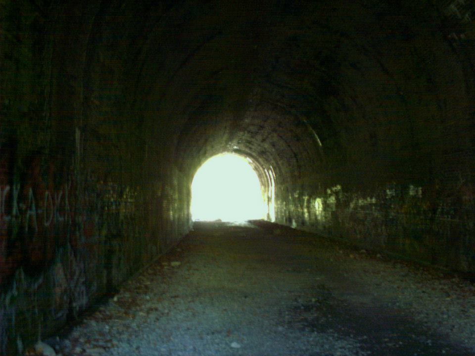
Moonville has been the most talked about and most popular ghost town in the state for a while now. Some visitors make a yearly pilgrimage to the site and are awed every time by standing in front of and walking through the nearly completely intact abandoned railroad tunnel that once had speeding trains rolling through it. The tunnel sits on the old railroad track bed heading East from Hope Moonville Rd. A new wood pedestrian bridge crossing Raccoon Creek, where the train trestle had been torn out, was constructed in 2016 with funds acquired from the state and raised by the Moonville Rail Trail Association. They hope to build more bridges along the rail trail and reconnect the nearby ghost towns of Ingham and Kings Station further east on the same railroad line.
Samuel Coe (1813 – 1883) donated land for a train station on the Marietta – Cincinnati Railroad (later bought by the B&O) in 1856, so he could move coal and clay off his property more easily to sell it. The town is always said to have been named after a Mr. Moon who operated a general store nearby. Unfortunately we were unable to locate any genealogy records on him. There was also a school run by Addie and Martie Coe, a tavern, hotel, and several residences that were scattered around the woods. The official population was never much more than 100 residents, even during it’s boom days, but many of the miners and railroad workers commuted from surrounding towns and travelers would sometimes stay for a night if the train they were on stopped at the station.
With no roads going through the rough terrain and densely forested area, the railroad tracks were the only way in and out of town.There are several confirmed deaths of people getting hit by trains, jumping off of the trestle as one approached, and jumping off the trains at certain points like where their houses were if they weren’t scheduled to stop at the station. There were also a deaths inside the tunnel. One of them was a brakeman that got crushed between train cars and a few people that got hit while walking home. David “Baldy” Keeton (1821 – 1886) , who was always described as being a local bully, is said to haunt the front of Moonville Tunnel. He got into a bar brawl one night at the tavern that was on top of the right side of the tunnel hill. Baldy was found dead on the railroad tracks the next day and reportedly throws pebbles at people from the top of the front tunnel entrance to let them know he’s there. David is buried in Keeton Cemetery in Lake Hope State Park off of SR 278.
Moonville was doing well up through the 1880s, but a bad smallpox epidemic in the 1890s lead to a major population decrease and all the mines shut down over the next couple of decades. There wasn’t many residents by the 1920s and the last family left in 1947. The postal dates of 1857 – 1902 factor in the office that served the residents moving around a lot and the name changing several times, including Moonville (1857 – 1858), Big Sand Furnace (1858 – 1863), back to Moonville (1863 – 1865), Hope Furnace (1865 – 1890), and Rue (1887 – 1902).
From the railroad path on Hope – Moonville Rd, the town was in the opposite direction of the pedestrian bridge, about 500 yards from the tunnel and past the next creek crossing. Portions of old buildings and one of the train yards were still intact up until around the 1970s, but all have since disappeared. The road to Moonville Cemetery is off of Hope – Moonville Rd and up a steep hill a few hundred feet from the old railroad track bed. Many of the Coe family members are buried there. The dug out foundation of their home is next to where the railroad bed crosses Hope – Moonville Rd. There are also several electric poles that once powered the town and other remnants along the railroad path.
Granville, OH (1805 – present farming, mill, railroad, and university town with numerous historical sites)
Classification: historic town
Location: Granville Township, Licking County – On SR 661 at the intersection of County Hwy 539
GPS coordinates: 40.067948, -82.520177
In 1804 residents from Granville and Granby, Massachusetts formed The Licking Company and purchased over 29,000 acres of land in Ohio. Around 150 or so of them arrived in Licking County in 1805 and immediately began platting the town with a total of 288 lots and plans for the community buildings that they would need.
In 1812 Orrin Granger (1788 – 1822) built a tavern and inn which also served as a stagecoach stop between Columbus and Newark. It was purchased in 1865 by Major Horton Buxton (1821 – 1902), a veteran of the Civil War. Major Buxton owned the inn until his death and it still carries his name to this day. Everyone from presidents and celebrities to regular common folks have enjoyed the inn and drank in its downstairs tavern for over 2 centuries. The Buxton Inn is currently the longest continually operated hotel in Ohio.
One of the other famous owners was Ethel “Bonnie” Bounell (1888 – 1960) was a dancer, singer, and entertainer. She operated the inn from 1934 – 1960. Her cat was named “Major” after Major Buxton. It’s still said to appear around the inn by the workers and visitors. Ethel Bounell and Major Buxton are also reported to still hang out there. Ethel is referred to as “The Lady In Blue”, for often wandering around in a blue dress. She reportedly passed away in room #9.
In 1972 Orville and Audrey Orr purchased The Buxton Inn after they heard it might be demolished. They restored the buildings over the last few decades and we had the privilege of speaking with Orville for a while, who we unexpectedly met in the restaurant room on the main floor. He was quietly sitting by himself reading the paper, and after greeting us in a friendly manner, Orville proceeded to tell us several of his own stories about the inn. It was an awesome experience and we give unending credit to Orville and Audrey for their love of The Buxton Inn and its history. It has since been sold and is under new management.
Granville had population booms with the building of Denison University in 1831, a large grain mill, and the railroad. Many of the 1800s buildings on the side streets and secondary roads in town survived and are now on the National Register of Historic Places. The train station from the Toledo & Ohio Central Railroad was built in 1880. It has been restored and sits at 425 South Main St (SR 661). Granville’s mill is still in operation and runs a general store across from the train station.
The Granville Inn, across the road from The Buxton Inn, was completed in 1924 and is also reportedly haunted. Ohio Historical Marker #23 – 45 at the intersection of Broadway and Main St (SR 661 and County Hwy 539) tells the story of The Licking Company and early settlers. Another neat Ohio Historical Marker is #21 – 45 on South Main St next to The Old Colony Burying Ground where most of the early settlers of Granville were buried. The town is a great trip for anyone who would like to spend a few hours or even a day or two visiting many different historical locations.
Buxton Inn Website – https://www.buxtoninn.com/
Sprucevale, OH (Spruce Vale) – (1835 – 1870 mill, farming, and canal town abandoned due to lack of economic opportunities)
Classification: ghost town
Location: Saint Clair Township, Columbiana County – On Sprucevale Rd along Little Beaver Creek about 3 miles north of Calcutta, OH
GPS coordinates: 40.706875, -80.580919
In 1835 the Hambleton brothers platted the town of Sprucevale around a small grist mill that they recently purchased. James Hambleton (1788 – 1869) operated the mill and served on the canal board. Charles Hambleton (1790 – 1864) ran the general store and post office. Benjamin Hambleton (1786 – 1869) had a saw mill, oil mill, and another general store. Issac Hambleton (1802 – 1895) managed a wool factory. The Sandy & Beaver Canal was built through town but was badly damaged when the local reservoir broke in 1852. It lost funding and maintenance as railroads in nearby towns had taken over the shipping industry. With no railroad and a dilapidated canal, Sprucevale’s days were numbered. The town had over a dozen homes and 20 families at one time, but there were only a few left by the end of 1870.
However, there was still a need for a post office to serve the surrounding area. An office opened in 1871 with William Huddleston (1825 – 1908) from Beaver County, Pennsylvania as the postmaster. He married Hannah (Smith) Huddleston (1825 – 1899) of Sprucevale in 1850 and they owned a farm across the road from the mill on the north side of Little Beaver Creek. Hannah was buried with her maiden family in Clarkson Cemetery 3 miles north of town on the west side of Sprucevale Rd in Middleton Township. William later moved out of the state and was buried with descendants in Viola Cemetery on the west side of US 67 in Mercer County, Illinois. Although Sprucevale is a ghost town, it’s still considered to be a populated place for census purposes.
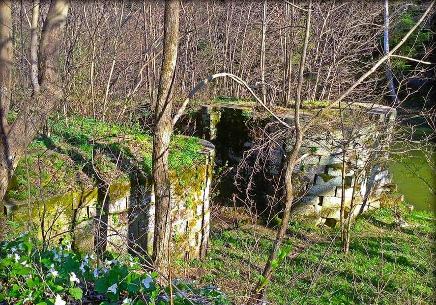
Canal lock #41, also known as Gretchen’s Lock, sits along the banks of Little Beaver Creek approximately a half mile west of Sprucevale Rd and is supposedly haunted by a girl named Gretchen Gill who died of malaria in Sprucevale. Her father, E. H. Gill, was an engineer of the Sandy & Beaver Canal. Gretchen’s death reportedly happened on August 12, 1838. The bridge over Little Beaver Creek on Spurcevale Rd is said to be haunted by Esther Hale, a bride to be whose groom took off the day before the wedding. As the story goes, Esther was found dead in her home a few months later still wearing her wedding dress and she can occasionally be seen at the bridge dressed in her wedding attire. The bridge has been replaced several times since the origin of the story, also from the late 1830s. Many details concerning both of the legends are continually in dispute.
Echo Dell Rd in Beaver Creek State Park is also the site of Gaston’s Mill which has been restored and opened to the public along with a few other old buildings. The Hambleton Mill was in extreme disrepair and was restored in the 1970s. It’s is an impressive sight to see on Sprucevale Rd just north of Beaver Creek. Ohio Historical Marker #10 – 15 is about 1/2 mile north of the mill. It marks the spot where gangster Charles Arthur “Pretty Boy” Floyd met his demise in 1934 when he encountered a large group of federal agents and local police just 3 months after being declared “public enemy #1” by J. Edgar Hoover.
Thanks to Brett Taylor, manager of Ohio Hiking Trails and Historical Sites, for providing the listing pic!
Waynesville, OH (1796 – present farming and stagecoach stop town)
Classification: historic town
Location: Wayne Township. Warren County – On US 42 at the intersection of North St
GPS coordinates: 39.530780, -84.085776
Waynesville was founded by Quaker settlers in 1796 and named after Revolutionary War veteran General “Mad” Anthony Wayne (1745 – 1796). Their journey by flatboat from Philadelphia over to Columbia in Hamilton County, Ohio and then up to Waynesville was documented by their guide Francis Bailey (1774 – 1844), an English scientist, astronomer, and adventurer. His book “Journal of a Tour in the Unsettled Parts of North America” was posthumously published in 1856. The Hammel House Inn at 121 S Main St began with a log cabin called the Hammel House Stand around 1800. It was rebuilt with a wood frame structure in 1817. The bricks section was added in 1822.
The building was renovated into apartments in the mid-1900s and turned into a bed and breakfast with a restaurant and gift shop in the 1980s. It’s reportedly haunted by several ghosts, including a black shadowy figure said to have passed through the wall from room #2 into room #3 where a guest was staying. The Waynesville Engine House and Lockup at 260 Chapman St was built in 1881 as the town’s first fire station. An addition in the back was constructed in 1886 and used for the jail. It was added to the National Register of Historic Places in 1999 and was up for sale when we visited.
Over on S 4th St. at the intersection of Miami St., the Museum At The Friends Home is another very impressive structure. It was built in 1905 by the Quaker’s Society Of Friends and was a boarding house for retirees and single teachers. The building is considered to be the gateway to the Quaker Historic District in Waynesville. The museum is open 1 p.m. – 5 p.m. on Wednesdays and Saturdays from April to December. Tours for the Quaker Meeting House, constructed in 1811 next to the museum are also available.
Town Website – http://villageofwaynesville.org/
Egypt, OH (Egypt Mills) – (mid-1800s – late 1800s farming and railroad town abandoned when the land was bought for coal mining)
Classification: ghost town
Location: Kirkwood Township, Belmont County – On Salem Ridge Rd heading east off of Co Rd 108
GPS Coordinates: 40.085233, -81.128718
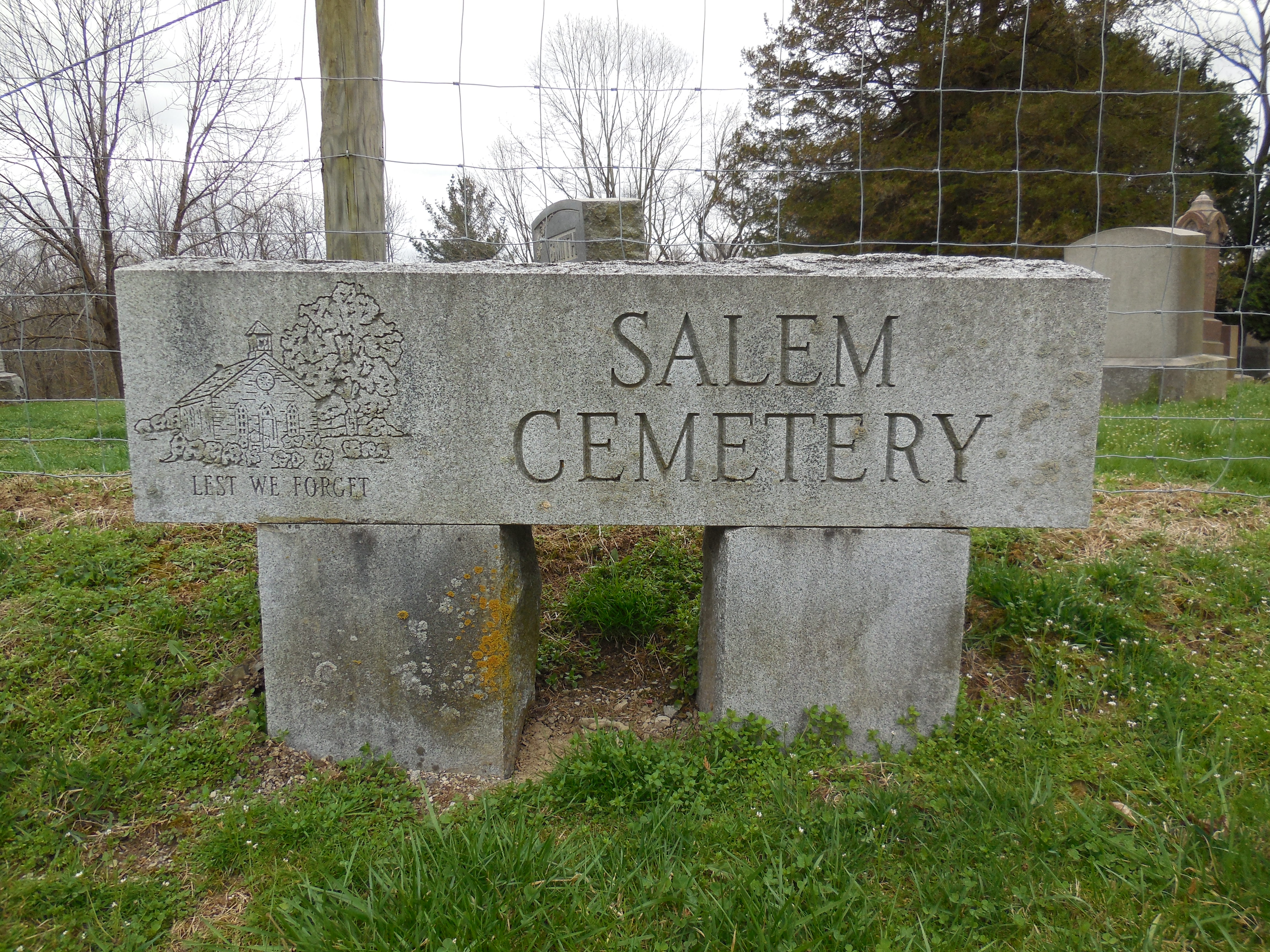
It had a few residents as early as the first decade of the 1800s but didn’t become a town until the mid-1800s. Egypt had a school, general store, a train station on the B&O Railroad, and a post office called Egypt Mills from 1852 – 1857. Another post office named Egypt was in operation from 1883 – 1905. The most popular locations these days are the 2 cemeteries, Salem and Old Egypt (Circle) Cemetery on Salem Ridge Rd, but there are also several decaying barns and houses in the area, a wood bridge, and remnants along the old railroad path.
Egypt Valley Wildlife Area is well known for its ghost stories. Louiza Catharine Fox (1856 – 1869) was engaged to be married with the much older Thomas D. Carr (1846 – 1870), who was a Civil War veteran. They met through Alex Hunter, the owner of a local coal company who they both worked for. Thomas worked in the coal mines and Louiza was a servant in Alex’s house. The engagement between Thomas and Louiza was originally approved by her parents, but they changed their minds when they heard rumors around town about Thomas’s violent side. The marriage was called off and the rumors unfortunately turned out to be true.
Thomas waited in the dark one night next to a road that Louiza used to walk home. She was with her little brother at the time, who Thomas told to go home so he could talk to Louiza. Instead of talking, Thomas kissed Louiza one last time and proceeded to slit her throat with a razor blade. Her little brother saw it happen from a distance and ran home to tell their parents. Thomas got arrested and was the first person hanged in Belmont County in 1870. Louiza is said to still haunt Salem Cemetery and can reportedly be seen or heard crying by her grave. Unlike most ghost stories around the state, the details concerning Louiza’s life story are real and historically accurate.
Another location that visitors of the ghost town are drawn to is a memorial for the site of Louiza’s murder. It has since been moved from the original location. The memorial is on the north side of Starkey Rd (Township Hwy 546). As with all of the sites to explore, getting there is quite an experience. The roads are low on maintenance priority with no residents living in the area anymore.
About a mile down the road from Salem Cemetery is the Old Egypt (Circle) Cemetery which is said to be haunted by the ghost of a truck driver who died in a crash around there. He lost an arm that was never found and the sounds of fingernails tapping on gravestones can supposedly be heard in the cemetery at night. The Old Egypt Cemetery is also reportedly haunted by “devil” dogs that guard it and can be heard howling in the woods nearby at night.
Boston Mills, OH (Helltown) – (1806 – 1974 mill and railroad town acquired by the Cuyahoga Valley National Park)
Classification: ghost town
Location: Boston Township, Summit County – On Boston Mills Rd at the intersection of Main St
GPS Coordinates: 41.263241, -81.559419
Boston Mills was settled by surveyors from Connecticut in 1806 who built a cabin on the grounds of what is now the Boston Cemetery. It was originally in Portage County and the township was named Boston after Boston, Massachusetts. The village also got the same name as it was the first in the township. There were several mills in the area including saw mills and paper mills operated by the Cleveland – Akron Bag Company. A post office was organized in 1825 but was discontinued later that year.
The town grew with the introduction of the Ohio & Erie Canal in 1827. A new post office opened in 1832. On top of the mills, it also had a warehouse, two stores, a hotel, school, blacksmith shop, broom factory, and several businesses that dealt in building boats for the canal. After the canal was abandoned, Boston Mills got a train station on the Valley Railroad which kept the area thriving for many more decades. The post office remained in nearly continuous operation until 1957.
There are a few stories of haunted places around the town. Boston Cemetery at the end of Main St is said to be haunted, as well as the “Crybaby Bride” on Boston Mills Rd that leads into town, and several other old buildings around the area. There are also stories about the Krejci Dump on Hines Hill Rd containing toxic substances and a government cover-up to stamp down the rumor. It was intensified in 1974 when Boston Mills was designated a national recreation area.
Some of the remaining residents were forced out by eminent domain and their houses were demolished as the town became part of the Cuyahoga Valley National Park. An urban legend of a giant snake from the reportedly toxic dump roaming around sometimes keeps people out of the woods, plus stories of local groups of cults and satanists who don’t want people to know what they’re doing back there. The “End Of The World” is the name given to the spot where a portion of Stanford Rd abruptly ends and is closed off from traffic.
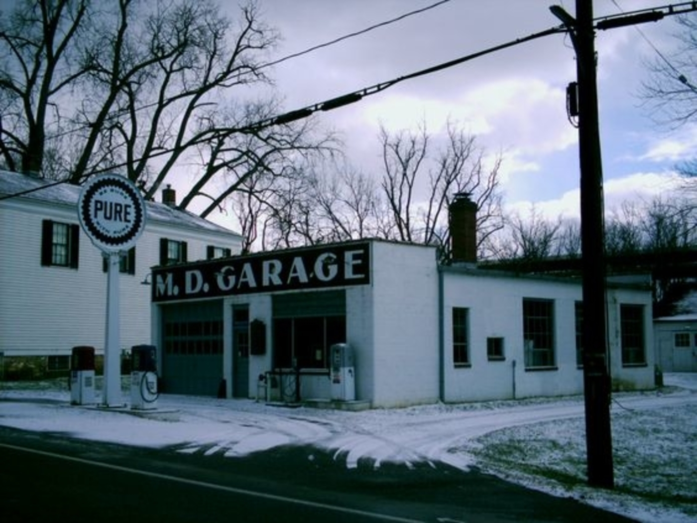
The Boston Mills Historic District was added to the National Register of Historic Places in 1992 and has a visitors center at the former store on Boston Mills Rd. M.D. Garage next to the visitors center was built in 1946 as a gas and auto service station. It’s restored and houses historical exhibits. Boston Community Church at the corner of Boston Mills Rd and Hines Hill Rd was constructed in 1911 and originally used as a school. A replica train station at the intersection of Riverview Rd (County Rd 9) and Boston Mills Rd is used by the Cuyahoga Valley Scenic Railroad which operates rides for local tourism. There are also many old houses in the historic district.
Palestine, OH (1837 – mid-1900s farming and stagecoach stop town slowly abandoned over time)
Classification: ghost town
Location: Franklin Township, Adams County – On SR 41 between Peebles and Locust Grove)
GPS coordinates: 38.970151, -83.394408
Revolutionary War veteran Peter Wickerham (1756 – 1841) and Maria (Platter) Wickerham (1767 – 1839) moved from Pennsylvania to Ohio in the late 1790s. They purchased a farm at the intersection of State Route 41 and Adkins Road. Back then, that portion of SR 41 was part of Zane’s Trace, an early pioneer road that stretched from Wheeling, West Virginia to Maysville, Kentucky. Realizing the importance of the location they chose to settle, Peter and Maria constructed the first brick house in the county in 1800 – 1801 with the idea of turning it into a tavern and inn for weary travelers along the road.
They platted the town in 1837. It had a school, blacksmith shop, and a church. The inn was the only continually successful business in Palestine. It remained in operation until about 1850 and was used to help escaped slaves hide out on the Underground Railroad. Morgan’s Raiders, a Confederate Army cavalry unit, rode through Palestine on July 15, 1863 during the American Civil War. Some of its soldiers stayed at the Wickerham Inn before continuing on their journey. Peter and Maria had 9 children and were buried with relatives in Locust Grove Cemetery at the intersection of State Route 41 and Cemetery Rd north of the inn.
The cemetery was established in 1800 and the town of Locust Grove was platted in 1835. Palestine couldn’t keep up with the growth of Locust Grove in the late 1800s. The same was the case with Peebles, which was platted to the south of Palestine in 1881 and quickly boomed with a newly laid railroad rolling through that area. Palestine didn’t have any accommodations at the time to attract travelers or more residents and faded out of existence in the mid-1900s. Shortly before the town disappeared from maps, a local legend resurfaced and still captures the attention of readers and listeners to this day.
An old tale of the inn being haunted suddenly regained relevance nearly a hundred years after its origin. As the story goes, a stagecoach driver who was thought to be carrying a large sum of cash was murdered in the upstairs room he rented for a night, but his body was never found. Reports by locals and travelers of seeing a headless man in the window of the room were usually dismissed as a ploy to draw more visitors to the inn and town. In 1922 while the inn was getting renovated, workers moved limestone slabs of the basement floor and discovered a headless skeleton underneath them. It’s considered by many to be the most likely haunted building in the county.
Lucy Run, OH – (1806 – late 1800s farming town)
Classification: ghost town
Location: Batavia Township, Clermont County – On Lucy Run Cemetery Rd off of SR 132
GPS coordinates: 39.043285, -84.192177
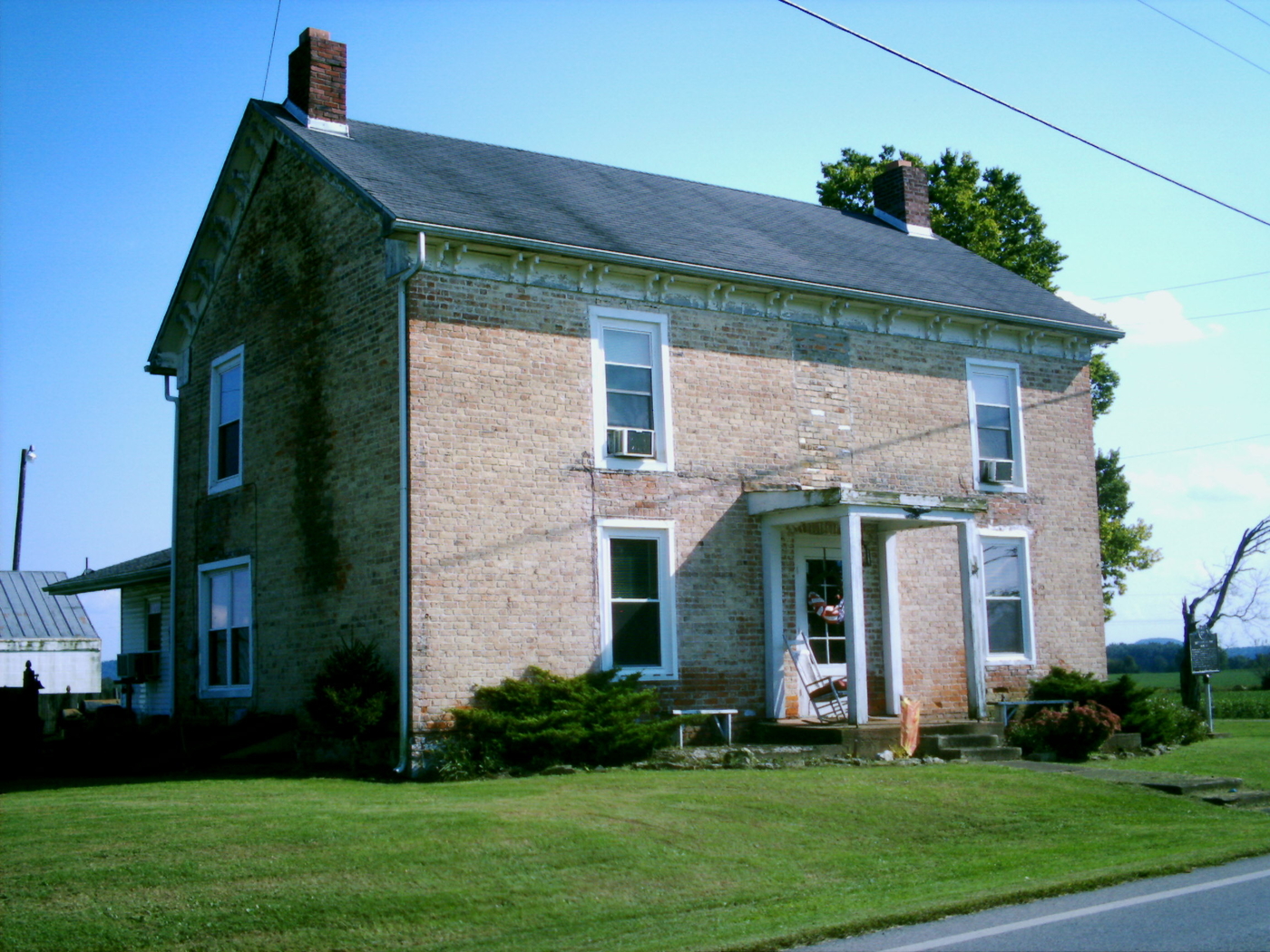
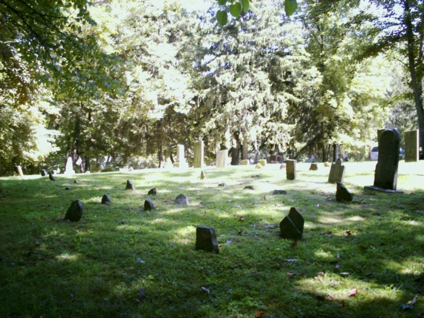
Lucy Run was first settled by Charles Robinson (1763 – 1846) and Asseneth (Martin) Robinson (1768 – 1835). Although the Robinson family is known to have lived in Maryland during colonial times, most genealogists state Charles was born in Virginia and the Robinsons lived in Kentucky prior to moving to Batavia Township. They arrived in the area of our subject in 1806. Charles was a farmer and Asseneth was known to have medical capabilities which were tough to find in those days. A Methodist congregation was organized at the Robinson cabin in 1808. Along with the help of neighbors, Charles built a log chapel around 1815 or 1816 that was called Robinson’s Church. The congregation later moved to Amelia and became the Methodist church there. Lucy Run also had a one-room schoolhouse that sits next to Lucy Run Cemetery and is currently a private residence. It has a county bicentennial marker including info on the county’s one room schools.
The area was reportedly named after Lucy Robinson, who by all accounts was either a daughter or niece of Charles and Asseneth. Her legend goes as follows. Lucy was engaged to be married in 1806 or 1807 with a local man who met another woman which he became romantically interested in. He showed up at the Robinson cabin one day and told Lucy the bad news that he couldn’t marry her because he was in love with someone else. After he left, the distraught Lucy mounted a horse and rode after him in an attempt to change his mind, or maybe kick his ass. No one is certain about that. A bad storm was rolling through the area and Lucy fell off her horse into the swollen creek near the Robinson cabin and drowned.
The creek was subsequently named Lucy Run and the stream and adjacent road still bear the name to this day. Lucy can supposedly be seen at night running in a white gown from the creek to the cemetery, or from the cemetery and across the creek to where the Robinson cabin was, looking for her estranged lover. It’s one of the most widely told ghost stories in Clermont County. Lucy is said to have been buried in an unmarked grave in the Robinson family plot in Lucy Run Cemetery on Lucy Run Cemetery Rd. The town never grew to be more than a hamlet and is currently considered to be part of Amelia.
Many historians doubt the authenticity of Lucy’s tale though. Numerous attempts, including one by our group, have failed to turn up any genealogical evidence supporting the legend and it’s unknown if she ever even existed. However, several women with the same name, Lucy or Lucinda Robinson, are confirmed to have been born in and lived in the county after the first decade of the 1800s. What may be even more bizarre, and adds to the mystery, is there’s a well-known true story about Mary (Robinson) Weaver (1789 – 1861) in the county history books.
Mary was definitely a daughter of Charles and Asseneth. She got stuck out in the woods at night during a snow storm in the fall of 1807 while on a 12 mile journey to the Mitchell cabin in Miami Township. She could hear wolves howling and getting closer as the night went on. Her horse knew the dangers of the howls as well and wouldn’t let Mary get near him. She paced around the horse all night, far enough away to not get kicked, but close enough to keep the wolves from attempting an attack. Mary made it to the Mitchell cabin in the morning and took several days to recover after getting sick. As interesting as that story is, it by no means compares to Lucy’s legend which didn’t make it into printed recorded history.
Fallsville, OH – (1848 – 1893 farming and mill town slowly abandoned over time)
Classification: ghost town
Location: Penn Township, Highland County – On hiking trails off of Careytown Rd
GPS Coordinates: 39.286200, -83.633054
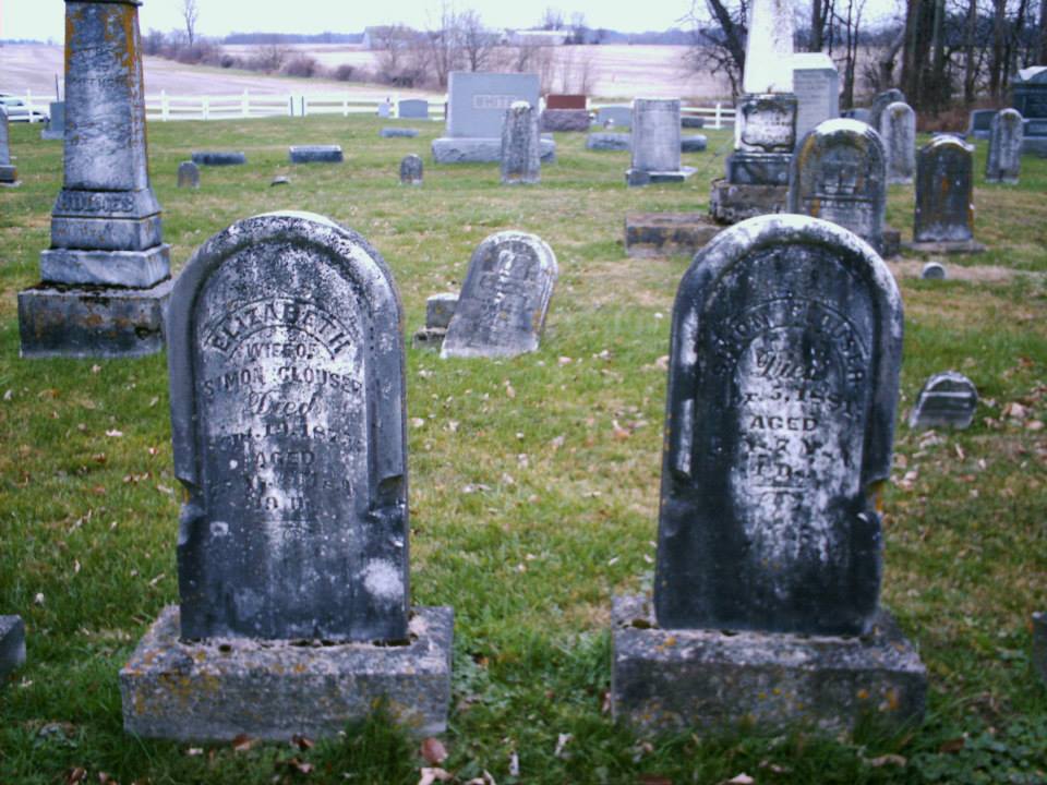
Fallsville was founded by John Timberlake who built a stone house and a grist mill next to the impressive waterfall on Clear Creek. In 1825 Simon Clouser (1796 – 1881) and his wife Elizabeth (Duckwall) Clouser (1797 – 1875) purchased the land from John and moved into the house in 1826. Simon was a farmer and operated the grist mill for people who came from miles around because it was the only large corn grinder in the area.
The Auburn Methodist congregation formed along with its first church structure, a log cabin built in 1830. On April, 20 1848 John Timberlake officially platted the town and named it after the waterfall next to the mill which is now part of The Fallsville Wildlife Area. More residents moved into town and Fallsville grew to have 8 houses on its 3 streets in the plat and a few more on the outskirts. The residents thought Fallsville would attract a railroad and become a large town, but that never happened.
Despite Fallsville being well on its way to fading out of existence, a new Auburn Methodist Church was built in 1891 to accommodate its members from the surrounding area. It replaced a smaller wood frame structure built after the log cabin church days and still stands today as the last structure built in town. Fallsville’s last remaining resident was Andrew Payton who died in 1893. Simon and Elizabeth Clouser were buried with their children at Auburn Church Cemetery on Careytown Rd. The Clouser girls were always described as being very strange, almost witch-like, and some of the locals steered clear of them so to speak.
The waterfall and remnants of the town are off of Fallsville Ln (Township Hwy 432), the gravel road south of Auburn Church. It’s blocked off from traffic, but a small parking lot at the front of the road is used for access. To get to the waterfall, keep going straight onto the trail past where the gravel ends on Fallsville Ln. The waterfall is on the right side of the path. Building foundations, sections of property line fences, and an old horse tank (the only one we’ve ever seen in a ghost town) can be found when hiking south from where the gravel ends on Fallsville Ln, a left turn heading into the woods.
Hunting goes on back there, especially during turkey season, so we recommend wearing bright colors while visiting. The hunters we met were all very nice and even gave us some info on where to look for remnants. Nature photography is another common activity in the wildlife area. Fallsville also has a ghost story about a Native American girl who knocks on doors around town on Christmas Eve. She’s said to be trying to tell local residents the location of a gold treasure buried nearby.
Dent, OH (Challensville) – (1843 – present former farming town partially abandoned over time)
Classification: small town
Location: Green Township, Hamilton County – On Harrison Ave south of I-74 and US 52
GPS coordinates: 39.177444, -84.645166
Dent was originally called Challensville and was named after the town’s first preacher, Rev. James Challen (1802 – 1878). The first house in town was the Three Mile Hotel which some of the early farmers in the area used as their residence. The Challensville post office ran from 1843 – 1846. Charles Gustav Reemelin (1814 – 1896) was a German immigrant and a state senator who lived in the town and had its name changed to Dent after a large depression in the earth near his house and vineyards. In its early days, Dent had a church, school, several stores, and a few dozen residences along Harrison Pike. The population was around 100 in 1895 and the post office ran from 1846 – 1904 when the mail started going through Cincinnati.
The town’s biggest claim to fame is the Dent Schoolhouse which was built in 1894. It’s said to be haunted by the ghosts of Charlie McFee (or McFree) and the children he killed. According to the legend, Charlie was a janitor at the school. Rumors of children disappearing in Dent began to circulate in 1942, but the story eventually lost its steam. However, 7 more children reportedly went missing in 1955 and the parents began to speculate about the strange smell that would occasionally rise from the basement.
Parents of the schoolchildren supposedly went down there and found the remains of a couple of dozen children hidden in the walls. Charlie the janitor was long gone, and although a reward was put out for his capture, he was never found or arrested. The school was closed shortly after that and has been converted into one of Ohio’s most popular haunted houses. It gets around 30,000 visitors every year during Halloween season. We’ve never seen any actual evidence of the school’s story being true, but it’s certainly interesting nonetheless.
The Dent Schoolhouse website – https://frightsite.com/
One-Time
Monthly
Yearly
Make a one-time donation
Make a monthly donation
Make a yearly donation
Choose an amount
$5.00
$15.00
$100.00
$5.00
$15.00
$100.00
$5.00
$15.00
$100.00
Or enter a custom amount
$
Your contribution is appreciated.
Your contribution is appreciated.
Your contribution is appreciated.
DonateDonate monthlyDonate yearly