

Granville, OH (1805 – present farming, mill, railroad, and university town with numerous historical sites)
Classification: historic town
Location: Granville Township, Licking County – On SR 661 at the intersection of County Hwy 539
GPS coordinates: 40.067948, -82.520177
In 1804 residents from Granville and Granby, Massachusetts formed The Licking Company and purchased over 29,000 acres of land in Ohio. Around 150 or so of them arrived in Licking County in 1805 and immediately began platting the town with a total of 288 lots and plans for the community buildings that they would need.
In 1812 Orrin Granger (1788 – 1822) built a tavern and inn which also served as a stagecoach stop between Columbus and Newark. It was purchased in 1865 by Major Horton Buxton (1821 – 1902), a veteran of the Civil War. Major Buxton owned the inn until his death and it still carries his name to this day. Everyone from presidents and celebrities to regular common folks have enjoyed the inn and drank in its downstairs tavern for over two centuries. The Buxton Inn is currently the longest continually operated hotel in Ohio.
One of the other famous owners was Ethel “Bonnie” Bounell (1888 – 1960) was a dancer, singer, and entertainer. She operated the inn from 1934 – 1960. Her cat was named “Major” after Major Buxton. It’s still said to appear around the inn by the workers and visitors. Ethel Bounell and Major Buxton are also reported to still hang out there. Ethel is referred to as “The Lady In Blue”, for often wandering around in a blue dress. She reportedly passed away in room #9.
In 1972 Orville and Audrey Orr purchased The Buxton Inn after they heard it might be demolished. They restored the buildings over the last few decades and we had the privilege of speaking with Orville for a while, who we unexpectedly met in the restaurant room on the main floor. He was quietly sitting by himself reading the paper, and after greeting us in a friendly manner, Orville proceeded to tell us several of his own stories about the inn. It was an awesome experience and we give unending credit to Orville and Audrey for their love of The Buxton Inn and its history. It has since been sold and is under new management.
Granville had population booms with the building of Denison University in 1831, a large grain mill, and the railroad. Many of the 1800s buildings on the side streets and secondary roads in town survived and are now on the National Register of Historic Places. The train station from the Toledo & Ohio Central Railroad was built in 1880. It has been restored and sits at 425 South Main St (SR 661). Granville’s mill is still in operation and runs a general store across from the train station.
The Granville Inn, across the road from The Buxton Inn, was completed in 1924 and is also reportedly haunted. Ohio Historical Marker #23 – 45 at the intersection of Broadway and Main St (SR 661 and County Hwy 539) tells the story of The Licking Company and early settlers. Another neat Ohio Historical Marker is #21 – 45 on South Main St next to The Old Colony Burying Ground where most of the early settlers of Granville were buried. The town is a great trip for anyone who would like to spend a few hours or even a day or two visiting many different historical locations.
Buxton Inn Website – https://www.buxtoninn.com/

Roscoe, OH (Roscoe Village) – (1816 – present canal town abandoned over time but is now a restored community)
Classification: historic town
Location: City of Coshocton, Coshocton County – On N Whitewoman St off of SR 83
GPS coordinates: 40.279160, -81.876429
The nearly abandoned town of Roscoe Village received a second chance when it was restored and annexed into the City of Coshocton, which was once its rival directly across the Muskingum River. Roscoe was originally called Caldersburg, settled by James Calder in 1816. James was a merchant whose business failed in Coshocton. After building his cabin on the other side of the river, James had a 24 x 50 log tavern and hotel constructed on the land and platted Caldersburg with 67 lots. Another brick tavern was built in 1821 and more businesses followed later that decade. Caldersburg had a post office from 1825 – 1831.
The town’s boom hit when the Ohio & Erie canal arrived. Construction began in 1827 and was completed in 1830. A church and a new post office were built in 1831. That same year, the town changed its name to Roscoe, after William Roscoe (1753 – 1831), a popular English author. The Walhonding Canal was built from 1836 – 1842. It stretched northwest to the edge of Coshocton County and connected to the Ohio & Erie Canal at Roscoe. When it was completed, Roscoe became one of the most important shipping centers on the entire canal system in Ohio. Many of the townspeople would come out to greet new boat arrivals.
In the 1840s Roscoe had 5 dry goods stores, 2 saw mills and flour mills, 2 grocery stores, a grain warehouse, and every other kind of business that towns needed in that era. Unfortunately, the town lost its railroad hopes as the City of Coshocton was chosen for a stations on the Wheeling & Lake Erie Railroad and the Pittsburgh, Cincinnati, Chicago, & St. Louis Railroad (Big Four). Roscoe’s worst fear came in 1913 when its canal system was almost totally destroyed in the massive flood that year. The town continued to lose population over the next few decades and the post office was disbanded in 1961.
A few years later, Edward and Francis Montgomery started efforts to restore the aging businesses and homes in Roscoe. The Roscoe Village Foundation was formed, which did an awesome job restoring the historic district! Although Roscoe is in the City of Coshocton these days, it still has its own identity and small town charm. As with the other historic business districts on this website, parking is free and most of the fun is within walking distance. Many of the restored buildings from the town’s early times have signs with building dates and historical info, making exploring and learning about the area very easy.
Canal boat rides on the Monticello III, which is pulled by draft horses, are offered from May to September at the landing at 23253 SR 83. Starting from the north and heading south on N Whitewoman St, Triple Locks Park is the fist cool place to check out. It has more info about the canal system and is a great spot for a picnic. The Roscoe Village Visitors center is near the intersection of N Whitewoman St and SR 83. They have souvenirs and can tell you absolutely anything you’d need to know about the town and local annual events.
Town Website – https://roscoevillage.com/
Zoar, OH (Zoar Village) – (1817 – present farming town with less residents than in the past)
Classification: historic town
Location: Lawrence Township, Tuscarawas County – On SR 212 at the intersection of Mineral City Zoar RD NE (2nd St)
GPS coordinates: 40.613469, -81.422328
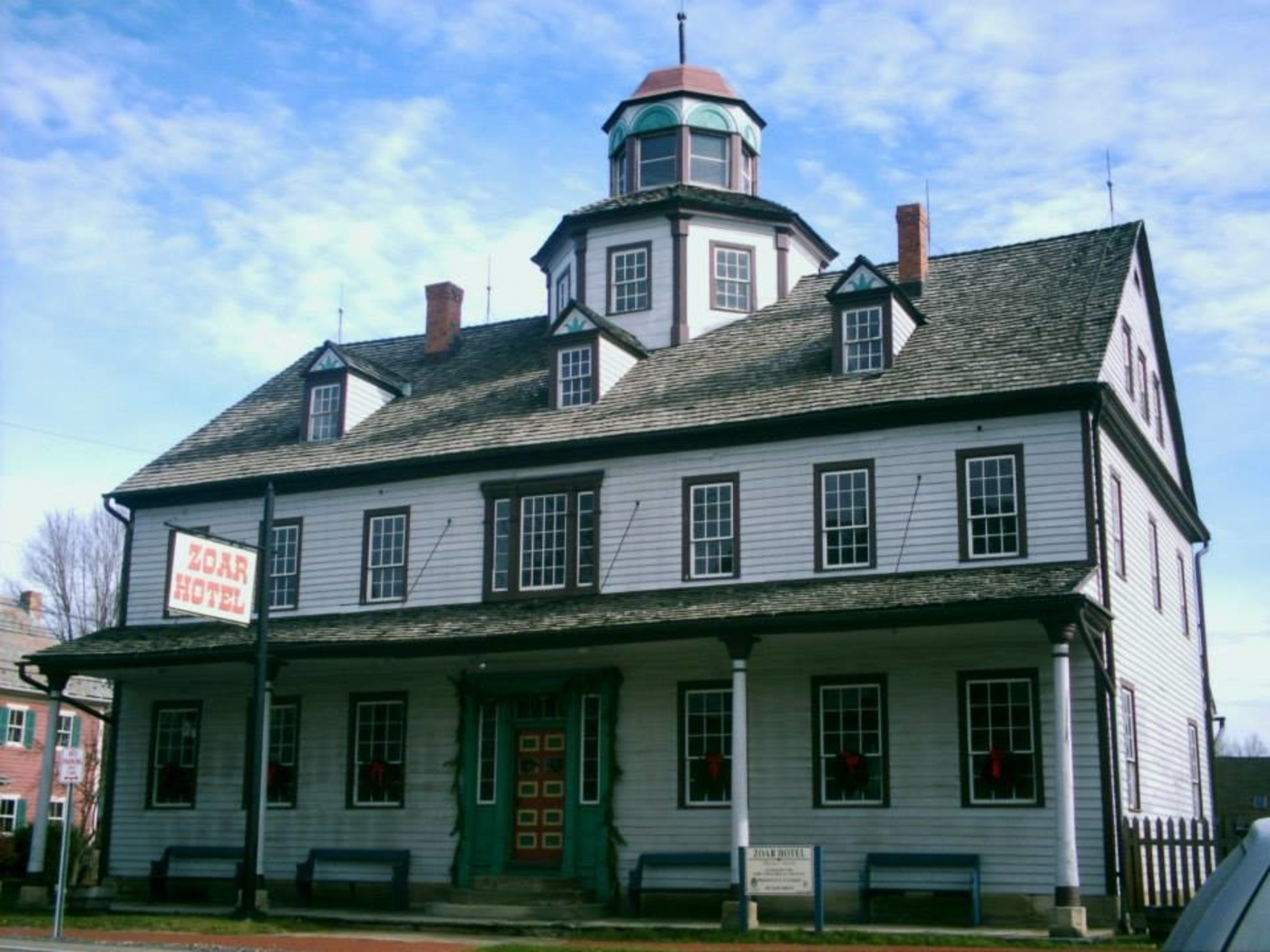
One of the coolest completely restored villages in the Ohio is on State Route 212 in Tuscarawas County. Its most recognized building is the reportedly haunted Zoar Hotel, built in 1833 on Main Street. Zoar was founded by immigrants who left Germany due to religious persecution from the Lutheran Church. They purchased 5,500 acres of land in Lawrence Township, in hopes of attaining a better quality of life. Joseph Bimeler (1778 – 1853) and Dorthea (Huber) Bimeler (1786 – 1852) founded Zoar along with 300 other settlers in 1817. It was named after the biblical city and means “sanctuary from evil”. Joseph was a pipemaker, teacher, and the leader of the group which was called The Society of Separatists of Zoar.
The Bimeler Cabin is the oldest structure in town. It was built in 1817 on 4th Street and was used as the first meeting house. Much of the land was acquired by loans that needed to be paid back quickly. The society bought the land sight unseen, and upon arrival, immediately began working on trying to figure out exactly what to do with it. They needed to know what crops could grow well there and which ones were most worth their time with planting and harvesting. Paying off the land loans as soon as possible reduced their accruing interest and lifted fears of repossession.
That goal became a source of motivation for the residents. On top of the financial stress, tensions ran high between the society members over several other aspects of life as well. Most of those tensions were ironed out in their articles of association written in 1819. The society was much like an Amish community, although there were some differences. Women worked right alongside the men in farming and did equal work. According to the articles, no one had individual rights of property. Everything was done for the good of the community and the citizens were given “the necessities of life – nothing beyond”.
A grist mill was built on the Tuscarawas River in 1821 to increase the town’s revenue and a post office opened in 1826. The state bought up some of the Society of Separatists land for the right of way of the Ohio & Erie Canal in the 1820s. Jobs for constructing 7 miles and 4 locks on the canal gave Zoar’s residents the opportunity to quickly pay off the land loans, which they accomplished by 1830 along with construction of a wool factory. The society was incorporated by the state as an organization in 1832. Over 50 of the town’s citizens died of cholera that year, but the population remained steady.
New member applications reached the post office on a near daily basis. Joining the society was tough and required making it through a probationary period. Applicants had to conform to the lifestyle, but work was easy to get. The town bought an iron furnace in 1834 that employed around 100 families. The Number One House is another impressive building in town. It was intended to be a home for the elderly. The idea was later scratched and it was given to the Bimeler Family. A second mill was built on the river in 1837. The community spread out into neighboring townships over the next few decades.
The Society of Separatists owned the train station on the Cleveland & Pittsburgh Railroad in nearby Fairfield, platted in 1854 on current-day State Route 800. It was called Zoar Station and had a general store and post office. Charles H. Ehlers (1839-1909) was the first postmaster. A group of members of the society platted Valley City with 28 lots in 1882, just a quarter mile north of Fairfield. 13 more lots were added crossing the border into Sandy Township in 1883. The name of the train station and post office in Fairfield changed to Zoarville in 1914, combining the 2 towns into one.
Back in Zoar, Joseph Bimeler’s death in 1853 caused dwindling interest in the community life and the villagers voted to disband the Society of Separatists in 1898. The town’s land was divided up between the remaining residents. A former house at the corner of E 3rd Street and Park Street was built as a house in 1863 and was owned by William Bimeler (1876 – 1928) and Lillian (Ruof) Bimeler (1876 – 1942). Lillian donated the building to the Ohio Historical Society. They converted it into The Bimeler Museum in the early 1920s. Zoar’s historic district, which encompasses pretty much the whole town, was listed on the National Register of Historic Places in 1969.
Other restored locations from the old village include the bakery, tin shop, wagon shop, blacksmith shop, dairy, and the kitchen and laundry. The garden in the middle of town is ornately planted. Historically, it has mostly been used for flowers and likely dates back to at least the 1820s. Zoar’s first school on E 3rd Street is a bed and breakfast. The Zoar Village State Memorial site is managed by the Ohio Historical Society and The Zoar Community Association. The store and visitors center is at 198 Main Street. Joseph and Dorthea Bimeler were buried in Zoar Cemetery at the end of 7th Street with most of the original society members.
Town Website – https://historiczoarvillage.com/
Grand Rapids, OH (Gilead) – (1833 – present farming, mill, and railroad town)
Classification: historic town
Location: Grand Rapids Township, Wood County and Providence Township, Lucas County – On SR 65 at the intersection of Wapakoneta Rd along the Maumee River
GPS coordinates: 41.415824, -83.860322
Peter Manor (1778 – 1847) settled in the area in 1816. He was a fur trader who previously operated a trading post for the Northwestern Fur Company. Peter built a saw mill in 1822 next to the Maumee River and expanded it with a grist mill in 1835. He platted the town of Providence in 1837 and had to sell off his mill to the state in 1838 during construction of the Miami & Erie Canal. Most of the 88 plats in the town, which were on five streets, were bought up and the town started to grow. Unfortunately a devastating fire swept through the business district in 1846.
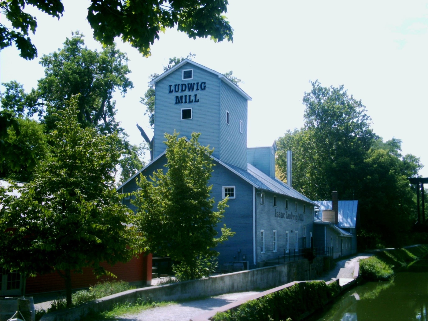
Peter died the next year while in the process of rebuilding his mill. Isaac Ludwig (1813 – 1906) and his wife Christenia (Ness) Ludwig (1819 – 1903) purchased the mill and completed its construction. Providence was hit by the cholera epidemic in the early 1850s and the population decreased again. Then it lost its post office which ran from 1836 – 1868. The town never had a railroad station and the closing of the canal was pretty much the last straw for Providence. Lucas County removed it from their recording list in 1928, turning it into a ghost town at the time.
With the success of Grand Rapids on the other side of the Maumee River in Wood County, originally platted as Gilead in 1833 and changed to Grand Rapids in 1868, the Providence area was never totally abandoned. Construction of Providence Metropark and its historic nostalgia made Ludwig Mill and former canal a neat tourist attraction. Although it presently has a Grand Rapids mailing address, Providence has basically regained its separate town status since then. It’s a populated place in Lucas County for census purposes and is listed on some maps as a current town despite technically being a ghost town.
The Ludwig Mill is restored and has a general store in Providence Metropark at 13827 Old US 24 Grand Rapids, OH 43522. It’s open from May to October, Wednesday through Sunday, 10 a.m. – 5 p.m. On Sundays they do full demonstrations of the mill operations from 1 – 4 p.m. and run a canal boat that passes by the abandoned Miami & Erie Canal Lock #44. There are also some other old buildings in the Providence Historic District, including St. Patrick Roman Catholic Church built in 1845. Grand Rapids has many historic sites to check out as well. Isaac and Christenia Ludwig were buried in Mount Pleasant Cemetery on Bailey Rd off of Providence Neapolis – Swanton Rd, about 3 miles north of town.
Mill and Metropark Website – https://metroparkstoledo.com/explore-your-parks/providence/

Clifton, OH – (1833 – present farming and mill town with little growth)
Classification: historic town
Location: Miami Township, Greene County and Green Township, Clark County – At the intersection of SR 343 and SR 72 (Springfield Jamestown Rd
GPS coordinates: 39.797171, -83.826274
Disgruntled that the Greene County seat was given to Xenia instead of Alpha, founded by the same family, Clifton was later founded by Owen Davis (1751 – 1818) and Laticia (Phillips) Davis (1750 – 1824) and their daughter and son-in-law Catherine (Davis) Whiteman (1775 – 1852) and General Benjamin Whiteman (1769 – 1852). Benjamin became a general in 1805 and served in the War of 1812.
In Clifton, Owen Davis built a mill and Benjamin Whiteman built a tavern, trading post, and a distillery in the first decade of the 1800s. The town quickly drew more settlers and was platted with 32 lots in 1833 by Timothy Bates and Bennet Lewis (1802 – 1876). They also donated land for the first church in Clifton and enlisted the services of a local carpenter, Abdael Kiler (1810 – 1891), to construct houses. He built 14 houses in summer of 1833 which were all bought that year. The town itself was said to be platted “square with the world”. We’re not exactly sure what that means, but if you take a closer look at it on the map, it’s easier to see why they said that. The name Clifton came from the rugged cliffs surrounding the Little Miami River in that area, sometimes reaching around 80 feet high. In its early days, Clifton had a blacksmith, saw mill, flour mill, a doctor, and a general store.
The town missed the railroad boom in the 1840s when the closest one was run through Yellow Springs 3 miles to the west, which was the first reason the population didn’t grow larger. The second reason came in 1849 when Clifton suffered from the worst Cholera epidemic of any town in Ohio based on its size. Half of the residents perished from it. Clifton bounced back some though and by 1918 the community had a town hall, jail, school, 2 stores, 3 churches, and an opera house that was fit to seat up to 500 people, good enough for a town twice its size. Clifton’s population was 152 in the 2010 census, far less than what its peak once was.
The town still has lots of old historical buildings including Benjamin and Catherine Whiteman’s original stone house and a restored mill on the same site as the one Owen Davis built. The current mill was originally built by Isaac Preston (1868 – 1950). The Davis family, Whiteman family, Abdael Kiler, and Isaac Preston are all buried in Clifton Union Cemetery on Tanyard Rd with relatives and many other early settlers.
Thanks to group member Brett Taylor, manager of Ohio Hiking Trails And Historical Sites, for providing the listing picture!
Mill Website – https://cliftonmill.com/

Waynesville, OH (1796 – present farming and stagecoach stop town)
Classification: historic town
Location: Wayne Township. Warren County – On US 42 at the intersection of North St
GPS coordinates: 39.530780, -84.085776
Waynesville was founded by Quaker settlers in 1796 and was named after Revolutionary War veteran General “Mad” Anthony Wayne (1745 – 1796). Their journey by flatboat from Philadelphia over to Columbia in Hamilton County, Ohio and then up to Waynesville was documented by their guide Francis Bailey (1774 – 1844), an English scientist, astronomer, and adventurer. His book “Journal of a Tour in the Unsettled Parts of North America” was posthumously published in 1856. The Hammel House Inn at 121 S Main St began with a log cabin called the Hammel House Stand around 1800. It was rebuilt with a wood frame structure in 1817. The bricks section was added in 1822.
The building was renovated into apartments in the mid-1900s and turned into a bed and breakfast with a restaurant and gift shop in the 1980s. It’s reportedly haunted by several ghosts, including a black shadowy figure said to have passed through the wall from room #2 into room #3 where a guest was staying. The Waynesville Engine House and Lockup at 260 Chapman St was built in 1881 as the town’s first fire station. An addition in the back was constructed in 1886 and used for the jail. It was added to the National Register of Historic Places in 1999 and was up for sale when we visited.
Over on S 4th St. at the intersection of Miami St., the Museum At The Friends Home is another very impressive structure. It was built in 1905 by the Quaker’s Society Of Friends and was a boarding house for retirees and single teachers. The building is considered to be the gateway to the Quaker Historic District in Waynesville. The museum is open 1 p.m. – 5 p.m. on Wednesdays and Saturdays from April to December. Tours for the Quaker Meeting House, constructed in 1811 next to the museum are also available.
Town Website – http://villageofwaynesville.org/

Germantown, OH – (1804 – present farming, mill town, and railroad town)
Classification: historic town
Location: German Township, Montgomery County – On State Route 725
GPS coordinates: 39.624979, -84.369033
Settlers with German ancestry from Berks County, Pennsylvania begn making their way to the vicinity in the first few years of the 1800s. Philip Gunckel (1766 – 1848) and Catharine (Shaeffer) Gunckel (1766 – 1836) led a group of 24 families by flatboat to Cincinnati, and then up to Hole’s Station, later named Miamisburg. Philip was the only one who could speak English at the time. The Gunckels made a land speculation investment by buying up a bunch of the original lot recordings in the valley between Little Twin Creek and Big Twin Creek, founding Germantown in 1804. They had 8 children and Philip was a miller.
In 1806 the Guckels built a saw mill and grist mill on their land. They platted Germantown in 1814 with the main street leading from the mill into the village. The mill was sold to the Gunckels son-in-law Lewis Shuey in 1930. He rebuilt and enlarged the mill to three and a half stories in 1845. A cigar manufacturing plant bought the mill in 1888 and also used it for a tobacco warehouse. Around that time, a two-story addition was attached to the right side of the building. It’s presently operated as the Shuey Mill Inn & Event Center at 313 S Main St. and is available for weddings and large events.
The Florentine Hotel at 21 W Market Street (State Route 725) started out as a brick structure that was completed in 1816. It’s currently the back portion of the former stagecoach stop and tavern. Two wood frame sections were added before 1860. Food was cooked for guests in the basement fireplace and traveled by dumb-waiter up to the restaurant on the first floor. The hotel had a few different names and 43 owners over the course of its life. It closed in 1974 while needing a lot of repairs. Two couples purchased it in 1976 and reopened the old hotel as a restaurant in 1979. Engine House Tattoo on E Center Street is a former firehouse that was built in 1858 after the original one was destroyed in a fire. It was restored in 1996 and has been the tattoo shop since 2012.
In 1976 the area around the Florentine Hotel was added to the National Register of Historic Places as Guckel’s Town Plan Historic District. Germantown had a train station on the Cincinnati, Jackson, & Mackinaw Railroad. The station was built in 1896 and has been restored. It sits with a small length of tracks next to W Warren Street in Veterans Memorial Park. Philip and Catharine Gunckel were buried with relatives in Germantown Cemetery on State Route 725 west of town. Heading further into the outskirts of town, State Road United Methodist Church was built in 1920. The church and cemetery behind it are on land that was donated by relatives of Catharine Gunckel.
Old Dutch (Moyer) Cemetery is a mile west of the church on the south side of State Route 725. It dates back to 1820s and is named after the Moyer family who owned much of the land in the area. Some of their ancestors arrived in Germantown with the Gunckels. Moyer Road around the corner from the cemetery is also named after them. The cemetery has about 100 interments. It was once overgrown but is now preserved with a chain link fence and a historical marker. The burial ground looked nicely mowed and all of the stones appeared to be in their rightful places.
Florentine Restaurant Website – https://florentine-restaurant.business.site/
Fowlers Mills, OH – (1834 – present farming and mill town with less residents than in the past)
Classification: historic town
Location: Munson Township, Geauga County – On Fowlers Mill Rd near the intersection of Mayfield Rd (SR 322)
GPS coordinates: 41.529172, -81.256280
Fowlers Mills was named after two brothers, Hiram Fowler (1800 – 1879) and Milo Fowler (1802 – 1860). They were born in nearby Burton, Ohio to parents from Connecticut and arrived in the area in 1829. Milo brought along his wife, Elanor (Foot) Fowler (1803 – 1875), and their 2 children. Hiram later married Minerva (Stone) Fowler (1809-1885) and had one child. The brothers built a millrace and saw mill along the Chagrin River on Fowlers Mills Rd, followed by a grist mill that opened for business in 1835.
A couple years after building the grist mill, the Fowlers traded it for a wool mill. The town’s post office was established in 1834 with Milo being the first postmaster. In 1837 Hiram was elected to one of the Munson Township trustee positions and Milo was a township treasurer. Milo constructed a new house for his family next to the grist mill in 1840. A marker for the Fowlers Mills Historic District is in the parking lot of the mill and has more info on the town and house. The two-story house was considered to be a frontier mansion when it was built, by far surpassing normal construction efforts of the time period.
The town also had a hotel, township hall, several stores, schools, and churches over the years. Hiram and Milo built more houses across the road from the mill in the 1840s. They’re easily identified while cruising through town with wooden “Century Home” plaques next to the doors. More markers can be spotted around the area and are mostly metal plaques, indicating structures that are on the National Register of Historic Places.
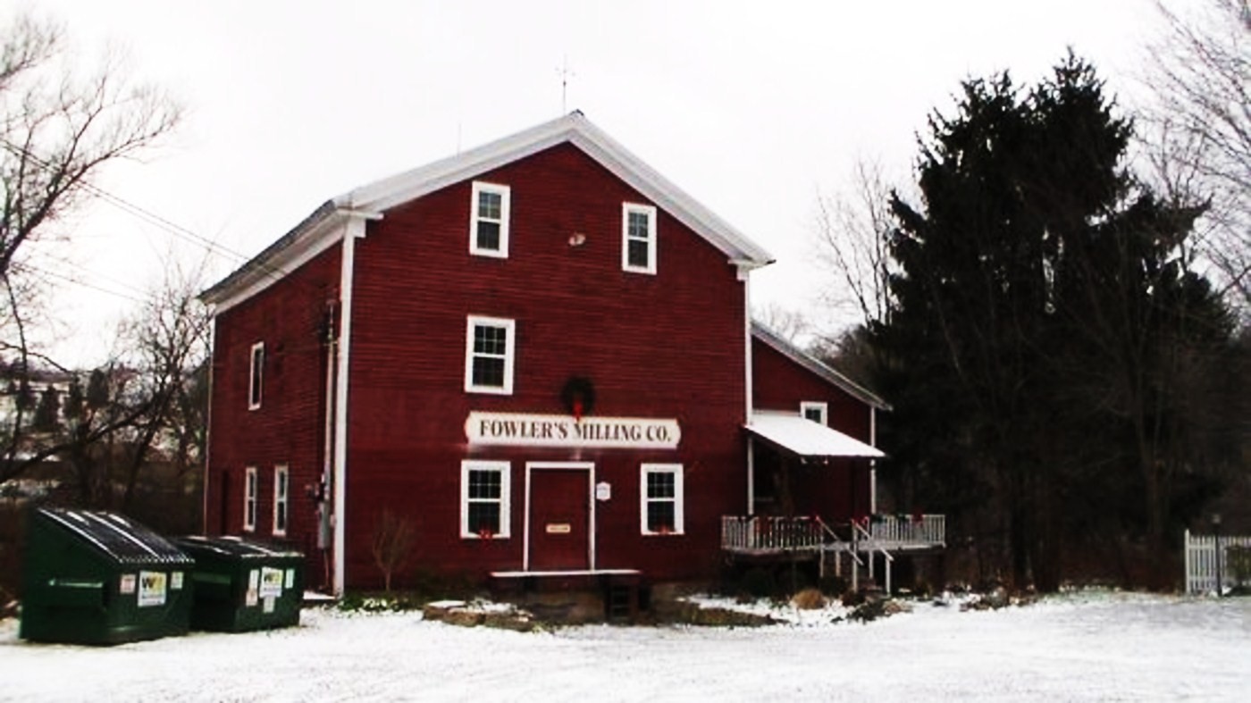
Fowler’s Milling Company changed ownership a bunch of times. It was listed as the last operating flour mill in Munson Township in the 1878 History Of Geauga And Lake Counties, Ohio. Charles S. Johnson purchased it in 1874. The mill was in bad shape by that time and needed a lot of repairs. Local residents were going to other mills in the county to get their grains turned into flour. Charles removed the turbine that powered the mill and replaced it with a 13 foot overshot water wheel with 2 sets of buckets for 2 sets of grinding stones. He also rebuilt the dam in 1877.
Those improvements lasted until production stopped in 1966. Rick and Billie Erickson bought the property in 1985 and restored the mill, making it the last surviving grist mill in Geauga County. It’s open Wednesday to Saturday from 10 a.m. – 5 p.m. and is closed on Sundays and holidays. The mill can produce 700 pounds of flour per hour from locally grown corn and wheat. It’s sold in the mill store and nationally by mail-order. Visiting is an amazing experience and a great reminder that the state’s best quality products aren’t always obtainable from the giant chain grocery stores, which most residents presently rely on.
The town’s cemetery is on the east side of Fowlers Mill Rd north of the mill. It’s a beautiful resting place and seems relatively small for the size and history of the community. Many residents were buried on family farm cemeteries. The gravestones of Hiram and Milo are in Bainbridge Township at Fowler Cemetery on the east side of Haskins Rd between Taylor May Rd and Crackel Rd. It was officially established in 1825 but had some interments prior to that, like many other cemeteries in Ohio that were originally on farms. The earliest known burials there are from 1811.
Mill website – https://www.fowlermill.com/
Georgetown, OH (1819 – present farming, mill, and merchant town)
Classification: historic town
Location: Pleasant Township, Brown County – on SR 125
GPS coordinates: 38.865694, -83.904395
Allen Woods (1767 – 1862) immigrated to the United States from Ireland and married Hannah (Galbreath) Woods (1767 – 1852) in Pennsylvania. They moved to Ohio in 1803 – 1804. Allen platted Georgetown along what is now State Route 125 with 22 lots and 2 outlots in 1819. It quickly acquired more plat additions from local landowners and became the county seat in 1821. The town was attracting everything it needed, including mills on White Oak Creek, grocery stores, hardware stores, blackmiths, and doctors. Public buildings such as new schools and churches were constructed whenever necessary. The population was at 618 in the 1850 census.
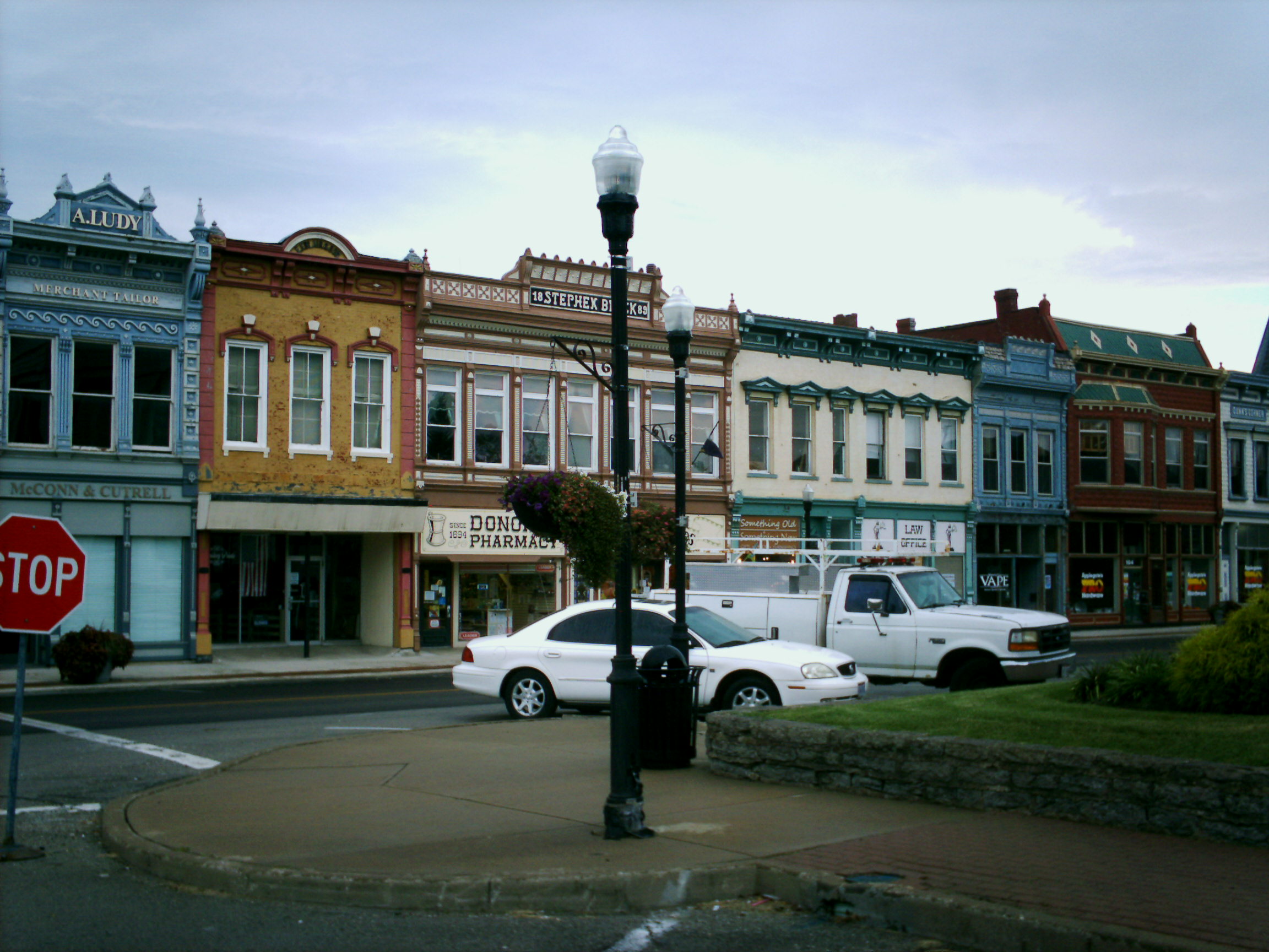
It was stated in the 1883 History Of Brown County, Ohio that Georgetown’s growth was slow but steady. The town had a train station on the Cincinnati, Georgetown, and Portsmouth Railroad from 1886 – 1936, but its arrival and existence didn’t create a major population boom for the town. Businesses usually did well in the town square though and were rarely unoccupied. The Georgetown Historic District was added to the National Register of Historic Places in 1978. It consists of 17 acres with 42 buildings and offers an alternative to the normal shopping experiences of the era. Parking is free in the town square and many historic structures are within walking distance.
In accordance with agreeing to be the county seat, Georgetown’s first courthouse was built in 1823 and eventually needed replaced. A much larger courthouse was completed in the town square in 1852. During the Civil War, and on the same day they reached the Wickerham Inn, a Confederate detachment of 200 – 300 of Morgan’s Raiders cavalry unit took control of the town square while stealing horses and goods from stores and residents. Long After surviving that day, a section of the courthouse was destroyed in an arson fire in 1977. Local citizens formed the Brown County Courthouse Reconstruction Association and raised funds for its restoration. The courthouse was rededicated in 1982.
General of the Union Army in the Civil War and 18th President Of The United States, Ulysses S. Grant, spent his childhood in Georgetown before leaving for the West Point Military Academy in 1839. His father Jesse Grant (1794 – 1873) and mother Hannah (Simpson) Grant (1798 – 1883) saved up $1100 in Point Pleasant, Clermont County. They moved to Georgetown and built their family home on Grant Ave in 1823 when Ulysses was just a year old. Jesse owned a tannery across from the house and ran a construction business. He was the mayor of Georgetown from 1837 – 1839.
The Grant’s home was purchased by John and Judy Ruthven in 1977. They donated it to the state in 2002. The house was declared a National Historic Landmark by the federal government and a total restoration was finished in 2013. The school Ulysses attended is restored on S Water St. Both are museums run by the Ulysses S. Grant Homestead Association. Georgetown is also home to the annual Brown County Fair. The population in 2010 was 4,331. It’s one of few old towns in Ohio that can boast of never having a lower 10 year census count than the prior one.
Town Website – http://georgetownohio.org/

Columbia, OH (East End) – (1788 – present river, farming, and railroad town with a ghost town within the current community)
Classification: historic town
Location: City of Cincinnati (formerly Spencer Township), Hamilton County – On Riverside Dr (US 52 / Kellog Ave) near the intersection of Wilmer Ave
GPS coordinates: 39.105735, -84.428539
Columbia was founded on November 18, 1788 by Revolutionary War veteran Major Benjamin Stites (1734 – 1804) who purchased 20,000 acres of land next to the mouth of the Little Miami River. He traveled with a group of 26 settlers down the Ohio River from Pennsylvania and started the first town in Hamilton County a month before Cincinnati (Losantiville) was settled. Columbia also went by the name of Turkey Bottom because of the 2 mile wide valley and fields next to the Ohio River that had an abundance of turkey and other game birds.
The town was initially just a cluster of log cabins around a few block storage houses, but it quickly grew to have 50 houses, a mill, and a school in 1790. The school was the first one in Ohio and the first school west of the original 13 colonies. It was run by John Reily (1763 – 1850), who was also a Revolutionary War veteran, as were most of the other men in the original group. The Columbia Baptist Church congregation also formed in 1790. They built the first church in Hamilton County in 1792. Reverend John Smith (1735 – 1824) was its minister and went on to be one of the first U.S. Senators from Ohio, serving from 1803 – 1808.
The biggest stories surrounding Columbia in the 1800s are that of its advancement of being a transportation hub. The only ways to get there in the early days were by canoe or flat boat on the Ohio River. Columbia had one of the earliest post offices in Ohio which ran by boat and horseback from 1819 – 1874. In 1835 the Anderson Turnpike wagon road connected Columbia with Cincinnati and Chillicothe. Then in 1841 the Little Miami Railroad swept through town. The Cincinnati, Georgetown, & Portsmouth Railroad had a line laid off of that in 1877 with the junction starting in Columbia and a train station on Carrell St. Cable cars were installed in 1890 and were operated by the Columbia Street Railway Co. The center of town moved north into the Tusculum hills due to flooding concerns of living near the river and the fact that Columbia flooded several times in the 1800s.
By 1900 Columbia acquired the name of East End, referring to it as the eastern edge of Cincinnati. Back then Columbia had several grocery stores, 3 hardware stores, 2 hotels, several saloons, a bank, theater, a restaurant, drugstore, and many other small businesses. The former Little Miami Railroad was bought out by the Pennsylvania Railroad in 1870. They had a station built on Torrence Rd off of Riverside Dr in 1907. It closed in 1933 and what’s left of it still sits on the railroad tracks between Riverside Dr and Columbia Parkway.
Edmund H. Lunken (1861 – 1944), a prominent local business man, proposed a 99 year renewable forever lease of 203 acres of his owned land in 1926 for an airport with the conditions that it be named after him and the city to escrow $60,000 for improvements prior to assignment. The lease was agreed to and signed by the mayor of Cincinnati in 1928. Lunken Airport is still in operation on Wilmer Ave. It has a museum operated by the Cincinnati Avaiation Heritage Society in Room 26 of the airport. A descendant of Edmund continues to hold onto the land deed and abide by the historic lease agreement. The family surname was originally Lunkenheimer, of German ancestry, and changed to Lunken in most of its branches during Edmund’s lifetime. He was laid to rest with relatives in Spring Grove Cemetery on Spring Grove Ave.
The town had another post office from 1927 – 1957. Columbia Baptist Church and Cemetery is across from Lunken Airport with parking in a small gravel lot off of Wilmer Ave. There are a few historical markers for the original site of Columbia in the cemetery where most of the early settlers were buried. A large column was built by the Baptist congregation in 1889 to commemorate their story. All four sides of the base of the column are engraved with info about them. In 1953 during the 150 year anniversary of Ohio’s statehood, a marker was placed at the front of the cemetery that tells the tale of Columbia’s early years.
Some other points of interest are original homes from the area including the Hezekiah Stites house (Benjamin’s son), built in 1835 at 315 Stites Ave, The James Morris house built in 1804 at 3644 Eastern Ave, and the Kellogg house built in the 1830s at 3811 Eastern Ave. The Columbia – Tusculum Historic District also operates a historic homes tour of the Victorian Era houses that were constructed in the Tusculum hills in the late 1800s and early 1900s. Another interesting sight is the Spencer Township Hall (township now defunct) that was built in 1860 at 3833 Eastern Ave. These days Cincinnati claims that Columbia – Tusculum is its oldest neighborhood, despite Columbia having a history all its own.
Thanks to Cliff Wartman of the Cincinnati Aviation Heritage Society for providing the info on Lunken Airport!
Town Website – https://www.columbiatusculum.org/
One-Time
Monthly
Yearly
Make a one-time donation
Make a monthly donation
Make a yearly donation
Choose an amount
$5.00
$15.00
$100.00
$5.00
$15.00
$100.00
$5.00
$15.00
$100.00
Or enter a custom amount
$
Your contribution is appreciated.
Your contribution is appreciated.
Your contribution is appreciated.
DonateDonate monthlyDonate yearly