
Moonville, OH – (1856 – 1947 coal mining and railroad town abandoned when mines shut down)
Classification: ghost town
Location: Brown Township, Vinton County – In Zaleski State Forest along the old railroad path that crosses Hope – Moonville Rd
GPS Coordinates: 39.308443, -82.324566
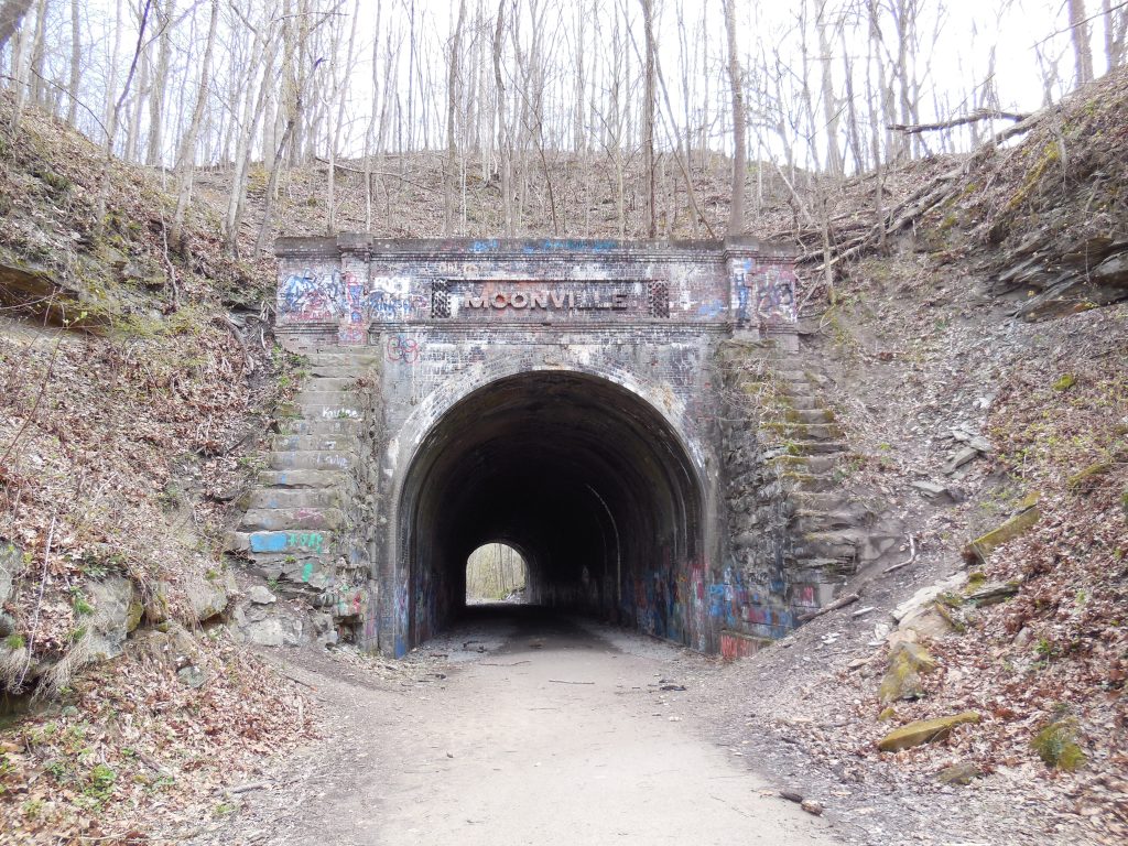
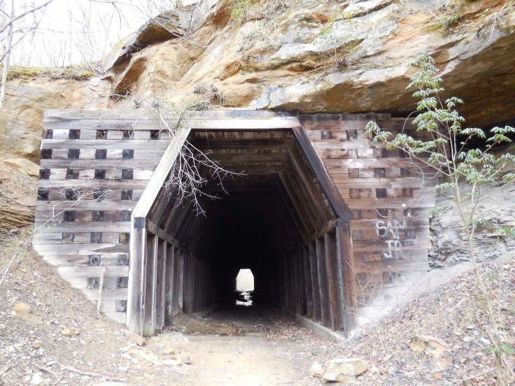
Moonville has been the most talked about and most popular ghost town in the state for a while now. Some visitors make a yearly pilgrimage to the site and are awed every time by standing in front of and walking through the nearly completely intact abandoned railroad tunnel that once had speeding trains rolling through it. The tunnel sits on the old railroad track bed heading East from Hope Moonville Rd. A new wood pedestrian bridge crossing Raccoon Creek, where the train trestle had been torn out, was constructed in 2016 with funds acquired from the state and raised by the Moonville Rail Trail Association. They hope to build more bridges along the rail trail and reconnect the nearby ghost towns of Ingham and Kings Station further east on the same railroad line.
Samuel Coe (1813 – 1883) donated land for a train station on the Marietta – Cincinnati Railroad (later bought by the B&O) in 1856, so he could move coal and clay off his property more easily to sell it. The town is always said to have been named after a Mr. Moon who operated a general store nearby. Unfortunately we were unable to locate any genealogy records on him. There was also a school run by Addie and Martie Coe, a tavern, hotel, and several residences that were scattered around the woods. The official population was never much more than 100 residents, even during it’s boom days, but many of the miners and railroad workers commuted from surrounding towns and travelers would sometimes stay for a night if the train they were on stopped at the station.
With no roads going through the rough terrain and densely forested area, the railroad tracks were the only way in and out of town.There are several confirmed deaths of people getting hit by trains, jumping off of the trestle as one approached, and jumping off the trains at certain points like where their houses were if they weren’t scheduled to stop at the station. There were also a deaths inside the tunnel. One of them was a brakeman that got crushed between train cars and a few people that got hit while walking home. David “Baldy” Keeton (1821 – 1886) , who was always described as being a local bully, is said to haunt the front of Moonville Tunnel. He got into a bar brawl one night at the tavern that was on top of the right side of the tunnel hill. Baldy was found dead on the railroad tracks the next day and reportedly throws pebbles at people from the top of the front tunnel entrance to let them know he’s there. David is buried in Keeton Cemetery in Lake Hope State Park off of SR 278.
Moonville was doing well up through the 1880s, but a bad smallpox epidemic in the 1890s lead to a major population decrease and all the mines shut down over the next couple of decades. There wasn’t many residents by the 1920s and the last family left in 1947. The postal dates of 1857 – 1902 factor in the office that served the residents moving around a lot and the name changing several times, including Moonville (1857 – 1858), Big Sand Furnace (1858 – 1863), back to Moonville (1863 – 1865), Hope Furnace (1865 – 1890), and Rue (1887 – 1902).
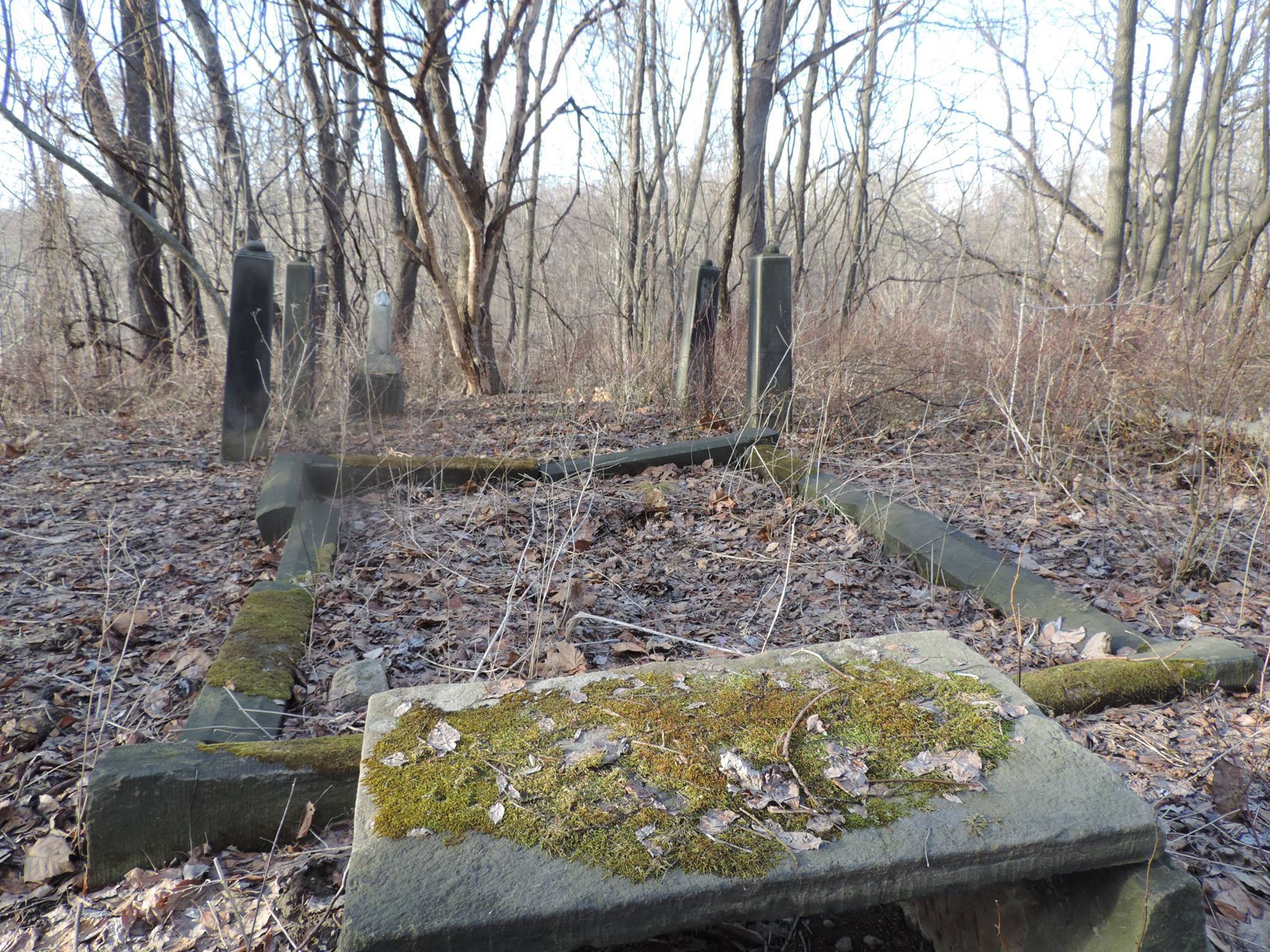
From the railroad path on Hope – Moonville Rd, the town was in the opposite direction of the pedestrian bridge, about 500 yards from the tunnel and past the next creek crossing. Portions of old buildings and one of the train yards were still intact up until around the 1970s, but all have since disappeared. The road to Moonville Cemetery is off of Hope – Moonville Rd and up a steep hill a few hundred feet from the old railroad track bed. Many of the Coe family members are buried there. The dug out foundation of their home is next to where the railroad bed crosses Hope – Moonville Rd. There are also several electric poles that once powered the town and other remnants along the railroad path.
Boston Mills, OH (Helltown) – (1806 – 1974 mill and railroad town acquired by the Cuyahoga Valley National Park)
Classification: ghost town
Location: Boston Township, Summit County – On Boston Mills Rd at the intersection of Main St
GPS Coordinates: 41.263241, -81.559419
Boston Mills was settled by surveyors from Connecticut in 1806 who built a cabin on the grounds of what is now the Boston Cemetery. It was originally in Portage County and the township was named Boston after Boston, Massachusetts. The village also got the same name as it was the first in the township. There were several mills in the area including saw mills and paper mills operated by the Cleveland – Akron Bag Company. A post office was organized in 1825 but was discontinued later that year.
The town grew with the introduction of the Ohio & Erie Canal in 1827. A new post office opened in 1832. On top of the mills, it also had a warehouse, 2 stores, a hotel, school, blacksmith shop, broom factory, and several businesses that dealt in building boats for the canal. After the canal was abandoned, Boston Mills got a train station on the Valley Railroad which kept the area thriving for many more decades. The post office remained in nearly continuous operation until 1957.
There are a few stories of haunted places around the town. Boston Cemetery at the end of Main St is said to be haunted, as well as the “Crybaby Bride” on Boston Mills Rd that leads into town, and several other old buildings around the area. There are also stories about the Krejci Dump on Hines Hill Rd containing toxic substances and a government cover-up to stamp down the rumor. It was intensified in 1974 when Boston Mills was designated a national recreation area.
Some of the remaining residents were forced out by eminent domain and their houses were demolished as the town became part of the Cuyahoga Valley National Park. An urban legend of a giant snake from the reportedly toxic dump roaming around sometimes keeps people out of the woods, plus stories of local groups of cults and satanists who don’t want people to know what they’re doing back there. The “End Of The World” is the name given to the spot where a portion of Stanford Rd abruptly ends and is closed off from traffic.
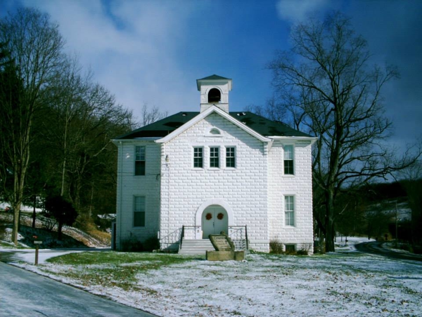
The Boston Mills Historic District was added to the National Register of Historic Places in 1992 and has a visitors center at the former store on Boston Mills Rd. M.D. Garage next to the visitors center was built in 1946 as a gas and auto service station. It’s restored and houses historical exhibits. Boston Community Church at the corner of Boston Mills Rd and Hines Hill Rd was constructed in 1911 and originally used as a school. A replica train station at the intersection of Riverview Rd (County Rd 9) and Boston Mills Rd is used by the Cuyahoga Valley Scenic Railroad which operates rides for local tourism. There are also many old houses in the historic district.
Egypt, OH (Egypt Mills) – (mid-1800s – late 1800s farming and railroad town abandoned when the land was bought for coal mining)
Classification: ghost town
Location: Kirkwood Township, Belmont County – On Salem Ridge Rd heading east off of Co Rd 108
GPS Coordinates: 40.085233, -81.128718
It had a few residents as early as the first decade of the 1800s but didn’t become a town until the mid-1800s. Egypt had a school, general store, a train station on the B&O Railroad, and a post office called Egypt Mills from 1852 – 1857. Another post office named Egypt was in operation from 1883 – 1905. The most popular locations these days are the 2 cemeteries, Salem and Old Egypt (Circle) Cemetery on Salem Ridge Rd, but there are also several decaying barns and houses in the area, a wood bridge, and remnants along the old railroad path.
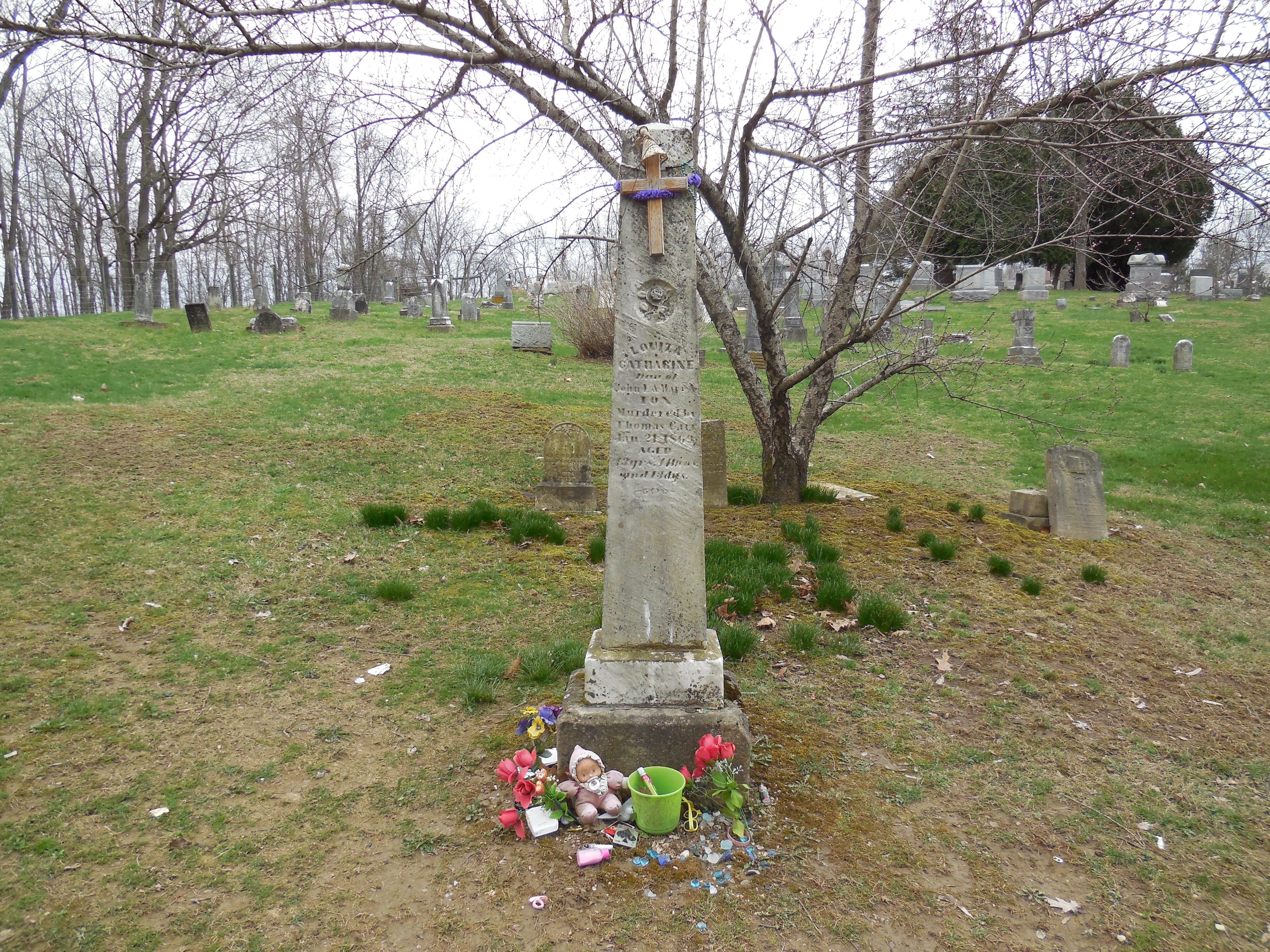
Egypt Valley Wildlife Area is well known for its ghost stories. Louiza Catharine Fox (1856 – 1869) was engaged to be married with the much older Thomas D. Carr (1846 – 1870), who was a Civil War veteran. They met through Alex Hunter, the owner of a local coal company who they both worked for. Thomas worked in the coal mines and Louiza was a servant in Alex’s house. The engagement between Thomas and Louiza was originally approved by her parents, but they changed their minds when they heard rumors around town about Thomas’s violent side. The marriage was called off and the rumors unfortunately turned out to be true.
Thomas waited in the dark one night next to a road that Louiza used to walk home. She was with her little brother at the time, who Thomas told to go home so he could talk to Louiza. Instead of talking, Thomas kissed Louiza one last time and proceeded to slit her throat with a razor blade. Her little brother saw it happen from a distance and ran home to tell their parents. Thomas got arrested and was the first person hanged in Belmont County in 1870. Louiza is said to still haunt Salem Cemetery and can reportedly be seen or heard crying by her grave. Unlike most ghost stories around the state, the details concerning Louiza’s life story are real and historically accurate.
Another location that visitors of the ghost town are drawn to is a memorial for the site of Louiza’s murder. It has since been moved from the original location. The memorial is on the north side of Starkey Rd (Township Hwy 546). As with all of the sites to explore, getting there is quite an experience. The roads are low on maintenance priority with no residents living in the area anymore.
About a mile down the road from Salem Cemetery is the Old Egypt (Circle) Cemetery which is said to be haunted by the ghost of a truck driver who died in a crash around there. He lost an arm that was never found and the sounds of fingernails tapping on gravestones can supposedly be heard in the cemetery at night. The Old Egypt Cemetery is also reportedly haunted by “devil” dogs that guard it and can be heard howling in the woods nearby at night.
Sprucevale, OH (Spruce Vale) – (1835 – 1870 mill, farming, and canal town abandoned due to lack of economic opportunities)
Classification: ghost town
Location: Saint Clair Township, Columbiana County – On Sprucevale Rd along Little Beaver Creek about 3 miles north of Calcutta, OH
GPS coordinates: 40.706875, -80.580919
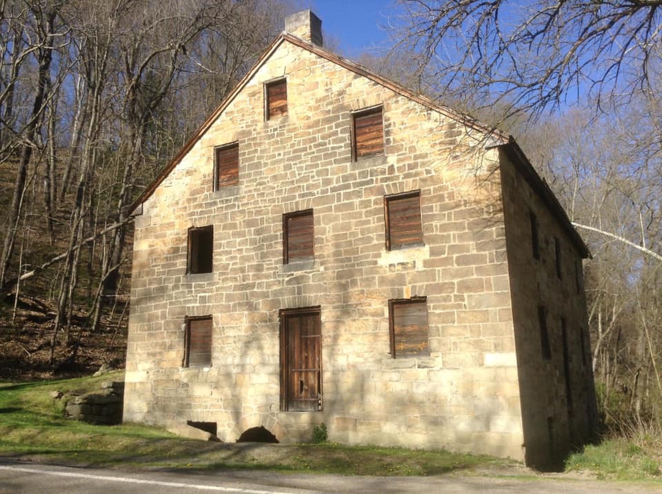
In 1835 the Hambleton brothers platted the town of Sprucevale around a small grist mill that they recently purchased. James Hambleton (1788 – 1869) operated the mill and served on the canal board. Charles Hambleton (1790 – 1864) ran the general store and post office. Benjamin Hambleton (1786 – 1869) had a saw mill, oil mill, and another general store. Issac Hambleton (1802 – 1895) managed a wool factory. The Sandy & Beaver Canal was built through town but was badly damaged when the local reservoir broke in 1852. It lost funding and maintenance as railroads in nearby towns had taken over the shipping industry. With no railroad and a dilapidated canal, Sprucevale’s days were numbered. The town had over a dozen homes and 20 families at one time, but there were only a few left by the end of 1870.
However, there was still a need for a post office to serve the surrounding area. An office opened in 1871 with William Huddleston (1825 – 1908) from Beaver County, Pennsylvania as the postmaster. He married Hannah (Smith) Huddleston (1825 – 1899) of Sprucevale in 1850 and they owned a farm across the road from the mill on the north side of Little Beaver Creek. Hannah was buried with her maiden family in Clarkson Cemetery 3 miles north of town on the west side of Sprucevale Rd in Middleton Township. William later moved out of the state and was buried with descendants in Viola Cemetery on the west side of US 67 in Mercer County, Illinois. Although Sprucevale is a ghost town, it’s still considered to be a populated place for census purposes.
Canal lock #41, also known as Gretchen’s Lock, sits along the banks of Little Beaver Creek approximately a half mile west of Sprucevale Rd and is supposedly haunted by a girl named Gretchen Gill who died of malaria in Sprucevale. Her father, E. H. Gill, was an engineer of the Sandy & Beaver Canal. Gretchen’s death reportedly happened on August 12, 1838. The bridge over Little Beaver Creek on Spurcevale Rd is said to be haunted by Esther Hale, a bride to be whose groom took off the day before the wedding. As the story goes, Esther was found dead in her home a few months later still wearing her wedding dress and she can occasionally be seen at the bridge dressed in her wedding attire. The bridge has been replaced several times since the origin of the story, also from the late 1830s. Many details concerning both of the legends are continually in dispute.
Echo Dell Rd in Beaver Creek State Park is also the site of Gaston’s Mill which has been restored and opened to the public along with a few other old buildings. The Hambleton Mill was in extreme disrepair and was restored in the 1970s. It’s is an impressive sight to see on Sprucevale Rd just north of Beaver Creek. Ohio Historical Marker #10 – 15 is about 1/2 mile north of the mill. It marks the spot where gangster Charles Arthur “Pretty Boy” Floyd met his demise in 1934 when he encountered a large group of federal agents and local police just 3 months after being declared “public enemy #1” by J. Edgar Hoover.
Thanks to Brett Taylor, manager of Ohio Hiking Trails and Historical Sites, for providing the listing pic!
Vinton Furnace, OH – (1854 – 1883 coal mining and iron furnace town abandoned when production stopped)
Classification: ghost town
Location: Elk and Madison Townships, Vinton County – On hiking trails off of Stone Quarry Rd
GPS Coordinates: 39.218200, -82.408200
Vinton Furnace was founded by Clark Culbertson & Company and eventually became a ghost town along with all of the other iron furnace operations in southeast Ohio. It started blasting in 1854 and ended in 1880. The furnace employed around 100 people who were paid in company store tokens for use at the general stores. One of them was on the north side of Elk Fork east of the furnace site. A row of small houses was built for the workers along with a school for their children on the trail heading north off of Stone Quarry Rd just west of the furnace site. The town’s post office ran from 1854 – 1901 with the name changing from Vinton Furnace to Vinton Station in 1857. Its postmasters over the years were Cyrus Newkirk, George Fry, Edward Elliott, Frank A. Austin, Frank P. Austin, John Hall, and Joseph A. Woodruff.
The train station on the Marietta & Cincinnati Railroad (later bought by the B&O) was northwest of the furnace on Vinton Station Rd at the intersection of US 50. There was also another general store and a blacksmith shop at that intersection. The railroad had a switch that ran southeast from Vinton Station to the furnace site. Part of the furnace, coke ovens, and the engine house foundation are still visible. The coke ovens were built in Belgium and only installed in a few furnaces around the world. They were made to produce coke fuel out of coal for smelting iron in the furnace better. Unfortunately the coke didn’t burn well and production costs ended up being part of the company’s demise.
The furnace site isn’t easy to get to. Stone Quarry Rd is a couple of miles east of McArthur, south off of US 50. Drive past a limestone quarry to where the road forks off. Take the left fork and go around a few bends to a trail that leads to a closed iron bridge in the woods on the right, heading west from the road. It’s actually an abandoned county road. Hike the trail staying to its right and follow the tree markers until you get to the furnace remnants. The ovens are up the hill behind the furnace. Despite being just about 2 miles from US 50, it’s amazing how remote the location seems to be while visiting.
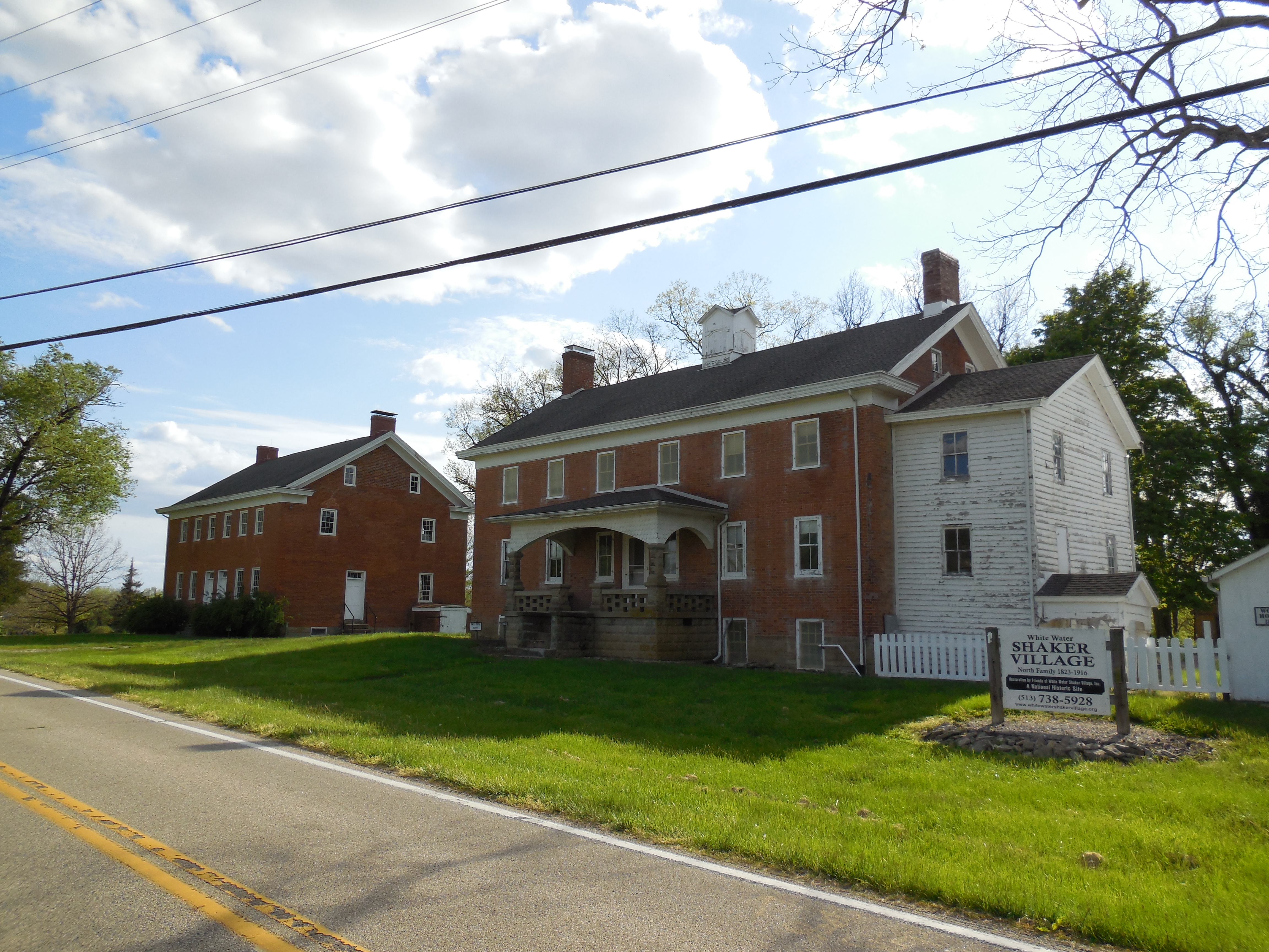
Shaker Village, OH (White Water Village) (Whitewater) – (1823 – early 1900s farming and religious town)
Classification: ghost town
Location: Crosby Township, Hamilton County – On Oxford Rd along Dry Fork Creek between Race Land Rd and New Haven
GPS coordinates: 39.302256, -84.749772
It was established in 1823 by a group of 18 members of the United Society Of Believers (also known as Shakers) who moved to Crosby Township from New Lebanon, Montgomery County. The village increased with 40 more members in 1824. Brick and wood frame houses were quickly raised to accommodate them and more land was purchased as needed. A group of 70 Second Adventists from Cincinnati doubled the size of the Shaker society in 1846. It split into an upper and lower village by publication of the 1847 county map.
The upper village just south of the township border has several buildings constructed from 1826 – 1849 which remain intact. The most prominent among them are the brick meeting house and large dwelling. The smaller buildings comprise of a wood house, milk house, Brethren’s Shop, ice house, chicken house, turkey coop, smoke house, and a stable with an attached wagon shed. A church and a saw mill in the upper village have since been lost to time.
A wood frame office was built in the lower village in 1855 and is intact along with a couple of other buildings, including the carpenter shop built in 1853 on the north side of the office and a large broom shop built across the road in 1876. The lower village was also the location of a sorghum mill, blacksmith shop and a school which have all disappeared from the landscape. Although the membership numbers rose and fell several times during the remainder of the 1800s, the Shaker’s land holdings kept growing and reached a peak of 1,300 acres in the mid-1890s with about 60 members. From then on, the membership dwindled and the town was eventually disbanded. The land was sold off by the society leaders in Canterbury, New Hampshire and the last residents left Hamilton County’s Shaker Village in 1916.
The buildings they left behind are impressive looking, to say the least, and almost seem to pop out of nowhere from the mostly rural landscape along that stretch of Oxford Rd. Burials in the cemetery just south of the lower village buildings date from 1827 – 1916. The Shaker Trace Trail is an 8-mile paved recreational path which loops around the lower village site. Parking is available in the Miami Whitewater Forest lot on Harbor Ridge Dr off of Mt Hope Rd on the south side of New Haven about 4 miles south of the GPS coordinates. The Friends of White Water Shaker Village, Inc. currently coordinates preservation efforts and events at the site.
Village Info – https://www.whitewatervillage.org/
Fallsville, OH – (1848 – 1893 farming and mill town slowly abandoned over time)
Classification: ghost town
Location: Penn Township, Highland County – On hiking trails off of Careytown Rd
GPS Coordinates: 39.286200, -83.633054
Fallsville was founded by John Timberlake who built a stone house and a grist mill next to the impressive waterfall on Clear Creek. In 1825 Simon Clouser (1796 – 1881) and his wife Elizabeth (Duckwall) Clouser (1797 – 1875) purchased the land from John and moved into the house in 1826. Simon was a farmer and operated the grist mill for people who came from miles around because it was the only large corn grinder in the area.
The Auburn Methodist congregation formed along with its first church structure, a log cabin built in 1830. On April, 20 1848 John Timberlake officially platted the town and named it after the waterfall next to the mill which is now part of The Fallsville Wildlife Area. More residents moved into town and Fallsville grew to have 8 houses on its 3 streets in the plat and a few more on the outskirts. The residents thought Fallsville would attract a railroad and become a large town, but that never happened.
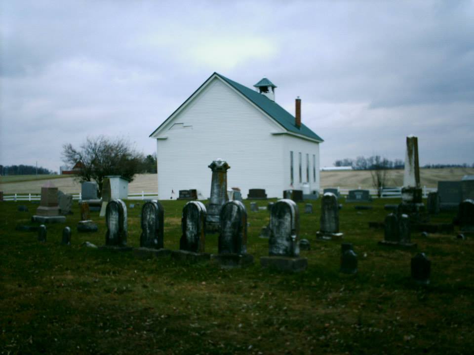
Despite Fallsville being well on its way to fading out of existence, a new Auburn Methodist Church was built in 1891 to accommodate its members from the surrounding area. It replaced a smaller wood frame structure built after the log cabin church days and still stands today as the last structure built in town. Fallsville’s last remaining resident was Andrew Payton who died in 1893. Simon and Elizabeth Clouser were buried with their children at Auburn Church Cemetery on Careytown Rd. The Clouser girls were always described as being very strange, almost witch-like, and some of the locals steered clear of them so to speak.
The waterfall and remnants of the town are off of Fallsville Ln (Township Hwy 432), the gravel road south of Auburn Church. It’s blocked off from traffic, but a small parking lot at the front of the road is used for access. To get to the waterfall, keep going straight onto the trail past where the gravel ends on Fallsville Ln. The waterfall is on the right side of the path. Building foundations, sections of property line fences, and an old horse tank (the only one we’ve ever seen in a ghost town) can be found when hiking south from where the gravel ends on Fallsville Ln, a left turn heading into the woods.
Hunting goes on back there, especially during turkey season, so we recommend wearing bright colors while visiting. The hunters we met were all very nice and even gave us some info on where to look for remnants. Nature photography is another common activity in the wildlife area. Fallsville also has a ghost story about a Native American girl who knocks on doors around town on Christmas Eve. She’s said to be trying to tell local residents the location of a gold treasure buried nearby.
Oreton Station, OH (Aleshire) – (1853 – 1950s coal, railroad, and iron furnace town slowly abandoned over time)
Classification: ghost town
Location: Vinton Township, Vinton County – On SR 160 about 5 miles north of SR 32
GPS Coordinates: 39.164055, -82.412693
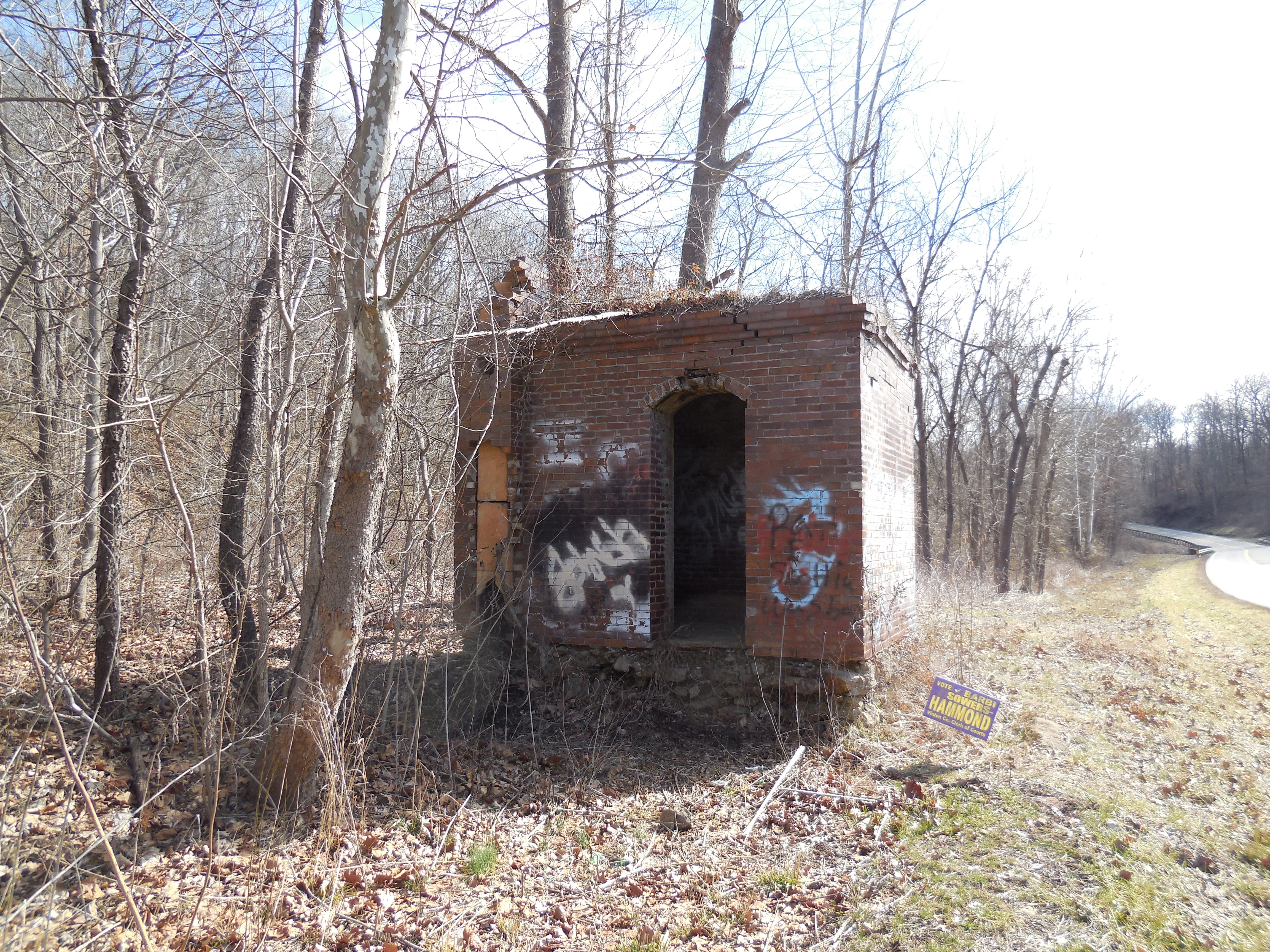
A good parking spot for exploring the area is right next to the only building that’s still intact. It’s the brick safe of the general store that was operated by David Eberts (1872 – 1961) who managed the New York Coal Co. in the 1930s and 1940s. There are also some interesting smaller structures, remnants, and mine entrances on hiking trails accessible from the parking area. The deck of a 17-train car length passing siding, for loading and unloading along the former railroad tracks, is on the left side of the trail heading west from the parking spot.
Before the New York Coal Co. arrived, most of the land was owned by C. K. Davis who operated the Alma Cement Co. in nearby Wellston. After the New York Coal Co. left, the mines were run by the Sunnyhill Coal Co. and lastly, the Peabody Coal Co. Oreton hit its boom days after construction of the Eagle Furnace in 1852. The residents mined iron for the furnace, coal, shale, and small amounts of silver. What’s left of the toppled over furnace sits next to a gravel access road on the opposite side of SR 160 from the brick safe. It had a post office from 1854 – 1858. Eagle Tunnel, that the Chesapeake & Ohio Railway went through, is still intact but is closed off with concrete. The last train rolled through it in 1930.
Oreton had 800 – 900 residents and commuting workers at its peak. There was 50 -70 houses, a one-room schoolhouse, and a church, but it never had a cemetery probably because most people just moved there for jobs. They were buried in cemeteries of other close towns or back on their family farms. David Eberts was laid to rest in Radcliff Cemetery on Radcliff Cemetery Rd off of SR 160 close to SR 32. His relatives were buried in Radcliff, Beard, Hamden, and Elk Cemeteries. The town was totally abandoned shortly after it lost its post office which was in operation from 1880 – 1950. Alice L. Eberts (1917 – 1980) was the last postmaster and was laid to rest with relatives in Elk (McArthur) Cemetery on the west side of SR 93 (N Market St) in McArthur.
It has been reported that the town was originally called Aleshire, according to postal records from before 1880, but there isn’t much info prior to it being called Oreton. It seems to be a ghost town within a ghost town. However, the Aleshires were a large early Ohio family, mostly living in Meigs and Gallia Counties in the first half of the 1800s, and many early Ohio towns were named after family last names. There are several Aleshire graves in Mound Hill Cemetery in Gallipolis, OH, about 35 miles south of Oreton and a strait shot down SR 160. The closest evidence we have to linking the town of Aleshire to the family surname is a record of an Alonzo Aleshire who was born in Vinton County in 1857. An Essie Alshire (1896 – 1918), spelled wrong or name changed, is also buried in Hamden Cemetery 7 miles west of Oreton. We suspect there may be an Aleshire family cemetery somewhere in the vicinity of Oreton that was either simply lost over time or destroyed by the mining industry.
Little Egypt, OH (1813 – 1951 farming, mill, canal, railroad, and crossroads town annexed by Walton Hills)
Classification: ghost town
Location: Bedford Township (defunct), Cuyahoga County – On Durham Rd at the intersection of Tinkers Creek Rd
GPS coordinates: 41.374042, -81.579774
Little Egypt was named after an odd mound structure on the Gleeson homestead that was once described as being pyramid shaped. The area was purchased by the Connecticut Land Company in 1795. A second land survey was conducted in 1797 during which Captain Joseph Tinker, the lead boatman, drowned with a few other men in what was later named Tinkers Creek. Crude roads were quickly built for travelers and settlers, but no one wanted to move there yet as there was nothing to move to except the land itself.
The first settler was Elijah Nobles who made the trip from Connecticut in 1813. He didn’t own any of the land but was given rights to live there by the Hudson family that established Hudson, OH as long as he promised to make improvements. A cabin was built for him at the present day site of Tinkers Creek Road Tavern by his closest neighbors that lived 3 miles away. Elijah didn’t like living so reclusive though and moved in 1814 to what would later become the Village of Bedford.
Later that same year, the Comstock family arrived from Connecticut and settled their parcel of land. The Comstock genealogy hasn’t been completely unraveled, as records from the time period are scarce, but Stephen Comstock was the patriarch. He probably married Marie Comstock in Connecticut where their first son Charles was born. Shortly after making it to Ohio, Sarah Comstock was born, the first child of settlers in Bedford Township. Stephen later had a few more children (not sure with who) and at least one other wife after Marie died in 1829. The family was successful in farming, hunting, and fishing, achieving the status of the first permanent settlers of the township.
In 1815 more settlers were making their way from the New England states and a combination saw and grist mill was built on Tinkers Creek that year. The Gleeson family arrived from New York in 1818. Moses Gleeson 1782 – 1868 and his wife Polly (Richardson) Gleeson (1789 – 1870) raised 10 children, all born in Ohio, and became the second prominent family and richest landowners in Little Egypt. They purchased the mill which already had its lumber section converted into more room for grinding grain. Production and sales went very well, so Moses and Polly used the profits to begin their next venture.
They set their sights on building a relatively lavish tavern and inn on the Cleveland – Pittsburgh Stagecoach Rd. The “World’s End Tavern” was constructed on the East side of Dunham Rd, back then called Egypt Rd South of Tinkers Creek. The tavern was 2 houses built together, one side for the family and the other side for lodgers, aptly named as it was situated on a steep hilltop overlooking Tinkers Creek. Another house was built by the Gleesons for the lockmaster of the Ohio & Erie Canal section that ran through town and opened in 1827. Behind the tavern, they established Gleeson Cemetery on the site of the pyramid shaped mound. Rebecca Gleeson, one of their children that died in infancy, was the first burial there in 1833.
Moses and Polly then built a nice 2 story brick house on the south side of Tinkers Creek in 1840, a steam-powered saw mill in what’s now the Hermit’s Hollow Picnic Area in the Bedford Reservation of the Cuyahoga Valley National Park. They also constructed a distillery on the modern day grounds of Astorhurst Golf Course. At that time, the Gleesons owned all of the land immediately east and west of Dunham and Egypt Roads.
So as not to overlook some of the history outside of the Gleeson family during the mid to late 1800s, the town also had a one-room schoolhouse next to Tinkers Creek, a general store, blacksmith shop, and a tavern called Ma Parker’s Tavern. It was owned by Mary Ann and Cardeo Parker who were from another large family in town. A house was purchased in 1880 to make a new school and a sandstone quarry was built in the late 1880s. Little Egypt was never incorporated and didn’t have a post office, but it could have proudly boasted of its growth in such a small area.
The Gleeson family surname changed to Gleason in some of its branches in the mid to late 1800s. Clara (Gleason) Carey (1851 – 1938), who was a granddaughter of Moses and Polly, inherited the estate and businesses. She moved into the World’s End Tavern with her husband Dominick Carey, a famous bridge and tunnel builder. Dominick built the Maple Wood Stock Farm for race horse training near the site of the old distillery. He tragically died in flood waters around the Main Street Bridge (one of his projects) that connected Ohio to Wheeling, WV in 1892.
The 1900s brought many changes and people to Little Egypt. A new tavern opened in 1902 at the old blacksmith shop. Construction of The New York Central Railroad began in 1904. Workers and engineers were brought in to build 2 trestles around town. Trains rolled through from 1911 to the early 1960s. Dunham and Egypt Roads were merged in 1907. Clara Gleason sold off the family land to Philip and Mary Astor in 1918. A new tavern opened in 1926 in the old blacksmith shop cabin and was owned by Charles Benada. A horse riding academy that opened in 1935, a beer garden, and a new general store in the 1940s kept the local economy going. In that era, cottages lined the streets and creek in town, creating a sort of touristy look. However, the much faster and more modern growing town of Walton Hills ended up overtaking the area and spelled the end for Little Egypt in 1951.
There are still several remnants of Little Egypt left around the Bedford Reservation though. Charlie’s Tavern is still open and is now Tinkers Creek Road Tavern and the old lockmaster’s house is a visitor’s center for the reservation. The Edmund and Charlotte (Comstock) Gleason House (Clara’s parents), built in 1851, is at 7243 Canal Rd in Valley View, OH. It was put on the National Register of Historic Places in 1978 and currently houses the Canal Corners Farm and Market.
A few of the gravestones are still intact in Gleeson Homestead Cemetery on top of the hill East of Dunham Rd across from the Astorhurst Golf Course. One of them is the gravestone of a grandson of Moses and Polly, Edmond Gleeson, who died on October 26, 1851 at 13 years and 11 months old. Most of the bodies were moved to Bedford Cemetery on Broadway Ave in Bedford, approximately 8 miles East of Little Egypt. The Comstocks and other early settlers were buried in Tinkers Creek Cemetery 1 1/4 miles west of the GPS coordinates north of Tinkers Creek Rd through the patch of woods behind Valley View Village Church.
The Walton Hills Historical Resource Center also conducts tours of Little Egypt, usually in March and May every year, meeting in the Hemlock Creek Pavilion parking lot in the Bedford Reservation. The one in March was for a hike to the Gleeson Cemetery and mound and the one in May a ride around tour for anyone that doesn’t want to do the hike. There are also numerous reports of hauntings in the area. Whether going out on your own or taking a guided tour, Little Egypt is an amazing ghost town to visit within a modern day community.
Tour Info – http://waltonhillsohio.gov/en-US/Ride-Around-Tour-Of-Little-Egypt05212015.aspx
Thanks to group member Richard Drurey, manager of Consigned To The Forgotten and Photos By RWD, for providing the listing lead, pic, and some of the info on Little Egypt!
Kings Station, OH (King Hollow) – (1856 – 1910s coal mining and railroad town abandoned when mines shut down)
Classification: ghost town
Location : Waterloo Township, Athens County – At the intersection of Rockcamp Rd and King Hollow Trail
GPS Coordinates: 39.319832, -82.284417
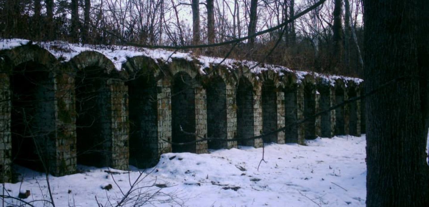
Kings Station was another coal mining town with a train station on the Marietta & Cincinnati Railroad (later bought by the B&O). It was northeast of Moonville and Ingham (Ingham Station), which were on the same railroad line, and had the same fate in becoming a ghost town. The hollow was named after the King family in the area. Although the previous generation of the family started the coal enterprise, Silas D. King (1840 – 1909) was the head proprietor for most of its existence. He married Sarah (Lyons) King (1851 – 1933) and had at least 2 children.
The town was on the southwest side of its wood railroad tunnel which was built in 1855 – 1856 and is a rare sight to see in Ohio. It had a general store, row of wooden houses, a school, coal tipple, blacksmith shop, and a post office from 1865 – 1894. Irwin R. King was the first postmaster. He was succeeded by Samuel H. King (1838 – 1914) who was buried with relatives 5 miles east of the GPS coordinates in New Marshfield Cemetery on Co Rd 6. Elmer G. Biddison (1863 – 1938) was the last postmaster and was buried in Athens (West Union Street Cemetery) in Athens.Silas and Sarah were laid to rest in Elk (McArthur) Cemetery on SR 93 (N Market St) in McArthur.
Thanks to group member Tammy Altman for providing the info on Silas D. King!
One-Time
Monthly
Yearly
Make a one-time donation
Make a monthly donation
Make a yearly donation
Choose an amount
$5.00
$15.00
$100.00
$5.00
$15.00
$100.00
$5.00
$15.00
$100.00
Or enter a custom amount
$
Your contribution is appreciated.
Your contribution is appreciated.
Your contribution is appreciated.
DonateDonate monthlyDonate yearly