Benton – Washington Township
Location: unknown
Description: David Hedges (1782 – 1860) built a saw mill and platted the town, naming it after the nationally famous politician Thomas Benton (1782 – 1858). Shortly after that, Emerson H. Eaton opened a general store in Benton and Alexander Alcorn (1812 – 1873) owned a chair shop. Alexander was buried with relatives and other early pioneers in Washington Township Cemetery on Range Line Rd along West Branch Tontogany Creek between Scott Rd (Township Hwy 217) and Kellogg Rd (Co Rd 184). Benton was mentioned in the 1897 county history book and had long since disappeared before its publication. David Hedges was laid to rest with relatives in Wakeman Cemetery on the south side of Farnsworth Rd in Waterville, Lucas County.
Browns Corners (Norris Station) (Koons) – Perry Township
Post Office: 1854 – 1862
Location: 41.217418, -83.458589
on SR 199 (McCuthenville Rd) at the intersection of Eagleville Rd along East Branch Portage River
Remnants: none known
Description: Its proprietor and postmaster, Justus Stearns (1810 – 1888) from Allegheny County, Pennsylvania, accumulated over 700 acres of land after moving to Perry Township in 1851. As the Toledo & Ohio Central Railroad (later bought by the B&O Railroad) was being constructed through the area. Justus and a couple of his sons intended to start a town around the GPS coordinates with plans for a hotel, several merchant shops, and bringing in manufacturing industries. They bit off more than they could chew so to speak, and ended up cancelling the venture as debts began to pile up. A couple of decades later, the area turned into Norris Station, with Civil War veteran Omar P. Norris (1838 – 1929) from Wayne County as the town’s proprietor and owning a steam-powered saw mill on the south side of Eagleville Rd at the intersection of Birch Rd. There was also a school (Perry Township No. 5) on the north side of Eagleville Rd east of Birch Rd. Although the town was called Norris Station at the time, the train station’s name was Koons. Justus Stearns was married 4 times and had 17 children. He was buried with relatives in Weston Cemetery on the east side of Van Tassel Rd in Weston Township. Omar Norris was buried with relatives in Fostoria Fountain Cemetery about 5 miles south of town on SR 18 (Van Buren St) in Hancock County.
Cass Corners – Liberty Township
Location: 41.327076, -83.689411
on Portage Rd at the intersection of Mitchell Rd
Remnants: Mt Zion Church just west of the GPS coordinates at the intersection of Portage Rd and Steen Rd
Description: The town was founded by Dr. Lewis H. Cass (1823 – 1898) from Wayne County and Amanda (Loveland) Cass (1825 – 1908) from Delaware County. They had 8 children and opened a general store near the intersection in 1868. Mt Zion Church was constructed in 1875 at a cost of $2,205. A school (Liberty Township No. 7) was northeast of the GPS coordinates in the southwest corner of the intersection of Powell Rd and Rudolph Rd on land owned by the McMahon family. Lewis and Amanda were buried with relatives in Weston Cemetery on the east side of Van Tassel Rd in Weston.
Cummings – Lake Township
Post Office: 1882 – 1898
Location: 41.558575, -83.493124
on Luckey Rd at the intersection of 66 (Moline Martin Rd)
Remnants: none known
Description: It had a train station on the Columbus, Hocking Valley, & Toledo Railroad and grew around a saw mill built by Giddings & Cummings. Frederick S. Giddings (d. 1913) was the postmaster. The town also had a stave factory, which was the site of an explosion in 1891, and a general store. Cummings fell into obscurity in the early 1900s.
Damtown – Liberty Township
Location: unknown
Description: Around the time the Coldwater railroad was being build through the area, Robert W. McMahan (1842 – 1911) opened a general store and J. D. Haley owned a grocery and drug store. Robert was buried with relatives in Portage Cemetery on the southeast side of County Home Rd in Portage Township.
Eberly – Henry Township
Location: unknown
Description: It was a small oil boom town on the Cincinnati, Hamilton, & Dayton Railroad north of Hammansburg in Henry Township and was named after a branch of the Eberly family in the county. Wood frame cottages for the workers lined its main street.
Farnham – Jackson Township
Post Office: 1871 – 1890
Location: 41.248115, -83.862190
on Roundhead Rd between Jerry City Rd and Cygnet Rd
Remnants: none known
Description: French immigrant Joseph Durliat (1831 – 1889) was the town’s postmaster. He married Magdalena (Trendall) Durliat (1838 – 1921) in Canada in 1856. They moved to Ohio in 1865, donated land for tracks for the Dayton & Michigan Railroad (later the Cincinnati, Hamilton, & Dayton), and owned a steam-powered saw mill on the east side of the railroad tracks. There was also a school (Jackson Township No. 5) on the west side of Roundhead Rd near the GPS coordinates. Joseph and Madgalena had 10 children and were buried with many descendants in Saint Louis Cemetery 4 miles northeast of the GPS coordinates on the south side of SR 281 (Defiance Pike) in Custar.
Fenton – Webster Township
Post Office: 1857 – 1901
Location: 41.454245, -83.558163
on SR 199 (McCuthenville Rd) between SR 582 (Middleton Pike) and Devils Hole Rd
Remnants: none known
Description: Fenton was once an important trading center in Webster Township, but missed out on the railroad boom and eventually couldn’t compete with towns such as Dowling and Dunbridge. It was founded by John Fenton (1792 – 1867) and Elisabeth (McGowan) Fenton (1793 – 1873) who arrived in the township in 1833 – 1834 along with a large group of Scottish immigrants. They owned a general store and John was the first postmaster. The town had a steam-powered saw mill on the east side of SR 199 south of the GPS coordinates. School was originally held in a log cabin until a new one-room structure (Wesbter Township No. 1) was built on the east side of SR 199 north of SR 582. There were a few other postmasters and store owners after John passed away. English immigrant Isaac Dent (1848 – 1929) and Martha (Emmitt) Dent (1852 – 1941) from Huron County kept it going during its last 11 years. Issac served as a school district supervisor and superintendent. Everyone mentioned in this listing was buried with local pioneers in Scotch Ridge (Webster Township) Cemetery about 3 1/2 miles south of the GPS coordinates on the west side of SR 199.
Haney – Jackson, Henry, Milton, and Liberty Township
Post Office: 1891 – 1903
Location: 41.255577, -83.766007
on Jerry City Rd at the intersection of Range Line Rd
Remnants: none known
Description: The town was founded by English immigrant and Civil War veteran William Haney (1818 – 1908) and Frances (Howes) Haney (1821 – 1893). They got married in 1852, had 3 children, and were buried with relatives in Milton Township Cemetery about 6 1/2 miles northwest of the GPS coordinates on the east side of Custar Rd. A tile works owned by the Lovell family was on the east side of Range Line Rd south of the GPS coordinates. There were 2 steam-powered saw mills in the area, one on the north side of Jerry Rd just west of the intersection in Milton Township on land owned by the Goit family, and another in Liberty Township on the east side of Potter Rd north of Jerry City Rd on land owned by the Roush family. A school (Jackson Township No. 1) was southwest of the GPS coordinates at the intersection of SR 235 (Otsego Pike) and Cygnet Rd. J. O. Haney was the town’s first postmaster. He was succeeded by John H. Cochrel (1858 – 1912) who opened up a grocery store in 1894. John was buried with relatives in Old Maplewood Cemetery on the south side of SR 18 (Briar Hill Rd) in North Baltimore. Willard E. Beal (1862 – 1946) was the last postmaster and was laid to rest in Bethel Cemetery on the east side of Rudolph Rd in Rudolph.
Lawrence (Bassett) – Henry Township
Location: 41.211871, -83.673676
on Oil Center Rd at the intersection of Carroll Rd along the Slippery Elm Trail
Remnants: none known
Description: Originally called Lawrence, Bassett was on the Cincinnati, Hamilton, & Dayton Railroad. It was named after the family of B. A. Lawrence and Elisabeth (Rosen) Lawrence who owned a steam-powered saw mill in the southwest lot of the intersection and donated land for a train station in the late 1800s. B. A. Lawrence struck oil in North Baltimore in 1889. He was also vice president of the People’s Banking Co. and served as township assessor. Sometime around 1900, the town name changed from Lawrence to Bassett. The current Slippery Elm Trail is part of the Wood County Park District and is a 13-mile paved recreational path along the former railroad bed.
Lovetts Grove – Center and Plain Township
Post Office: 1852 – 1871
Location: 41.408413, -83.650739
on SR 25 (N Dixie Hwy) at the intersection of Bishop Rd
Remnants: historical marker on the west side of SR 25 between Bishop Rd and Nims Rd
Description: The town was named after William Lovett who donated land for the first Seventh-day Adventist church in Ohio. It was constructed in 1864 and was moved to Bowling Green at the intersection of S Enterprise St and Lehman Ave in 1911. Lovetts Grove also had a steam-powered saw mill and a school west of the GPS coordinates in the southwest lot of the intersection of Bishop Rd and Brim Rd. Peleg G. Thomas was the first postmaster. He was succeeded by John T. Sweet (1826 – 1892). John was buried with relatives and other residents of Lovetts Grove 2 miles northwest of the GPS coordinates in Union Hill Cemetery on the east side of Brim Rd.
Miltonville – Middleton Township
Post Office: 1835 – 1862
Location: 41.487214, -83.716040
on SR 65 (W River Rd) at the intersection of Ovitt Rd
Remnants: Miltonville Cemetery on the east side of SR 65 south of Ovitt Rd near Riverby Hills Golf Club, historical marker in the Miltonville Fishing Access parking lot on the west side of SR 65 just north of the GPS Coordinates
Description: It was platted in 1835 by William Fowler and George W. Baird (1804 – 1856) who operated a saw mill, hotel, and a general store at the site. The town was named after Milton Baird (d. 1833). Epaphroditus Foote (1791 – 1857) from New London County, Connecticut was the first postmaster and served in several township positions. He was succeeded by William Ewing (1812 – 1895). Miltonville was hit hard with floods, cholera, and got passed up by the Dayton & Michigan Railroad in the mid-1800s. The historical marker has a lot of info about the town and surrounding area. It states that the post office closed in 1959, but it was listed in official postal records until 1862. Miltonville was also listed in the 1886 and 1912 county atlases, indicating it was still barely hanging onto its name and existence. George Baird and William Ewing were laid to rest in Fort Meigs Cemetery on W Indiana Ave in Perrysburg. Epaphroditus Foote was buried with relatives in Otsego Cemetery 5 miles southwest of the GPS coordinates on the south side of SR 65 in Washington Township. Miltonville Cemetery isn’t very large, but it is interesting to visit and contains gravestones of several war veterans who were early residents of the area.
Montgomery Cross Roads – Montgomery Township
Post Office: 1837 – 1863
Location: 41.302648, -83.507452
on McCuthenville Rd between Greensburg Pike and Mermill Rd along South Branch Portage River
Remnants: none known
Description: Montgomery Cross Roads had the first post office in the township. Guy Morgan (1785 – 1842) from New London County, Connecticut was the first postmaster. He was buried with relatives in Riverview (West Millgrove) Cemetery about 4 1/2 miles south of the GPS coordinates on the south side of Sandusky St (Township Hwy 3) in Perry Township. One of Guy’s sons, Ezra Morgan (1821 – 1862), took on the postmaster position after he passed away. Ezra moved out of the state and was buried with relatives in Dewitt City Cemetery on the east side of N Bridge St in Clinton County, Michigan. George B. Hedge (1819 – 1905) from Merrimack County, New Hampshire and Catherine (Crawfoot) Hedge (1829 – 1896) from Cuyuga County, New York were the last proprietors. George was the postmaster and operated a steam-powered saw mill until 1889. Their sons operated a brick and tile works on the east side of McCuthenville Rd north of the GPS coordinates. The Hedge family was buried in Graham Cemetery on the south side of Graham Rd (Township Hwy 167) between Wayne Rd and Pemberville Rd.
Oil Center – Bloom Township
Post Office: 1887 – 1894
Location: 41.211179, -83.644970
on Oil Center Rd at the railroad crossing between I-75 and Bushey Rd
Remnants: oil tanks along the railroad tracks between Tank Farm Rd and Oil Center Rd
Description: It was on the Toledo, Columbus, & Cincinnati Railroad (later the Toledo & Ohio Central Railroad) and was named after an abundance of oil in the area. The town had a school (Bloom Township No. 4) in the northwest corner of the intersection of Oil Center Rd and Bushey Rd and a steam-powered saw mill owned by the Bushey family south of the school on the east side of Bushey Rd. The Ohio Oil Company, Buckeye Pipeline Company, and Standard Oil ran the oil interests around town. Its necessary holding tanks became the namesake of Tank Farm Rd. Civil War veteran James W. Eidson (1847 – 1917) was the postmaster. He was buried with relatives in Oak Grove Cemetery on E Merry Ave (96) in Bowling Green. Wood county was the center of northwest Ohio’s oil boom which lasted from about 1885 – 1915. However, operations at Oil Center went on for several decades after that. The Wood County Historical Center & Museum is 11 1/2 miles north of Oil Center on County Home Rd in Bowling Green and features an outdoor display with an oil rig, buildings, and other equipment related to the industry.
Museum Info – http://www.woodcountyhistory.org/
Orleans – City of Perrysburg
Location: 41.556056, -83.645331
on Maumee Western Reserve Rd between the Maumee River and W Boundary St
Remnants: Orleans Park at the GPS coordinates, Fort Meigs Cemetery just east of the GPS coordinates at the intersection of US 20 and W Boundary St
Description: As with Miami (Maumee) in Lucas County, a settlement was made next to Fort Meigs in Wood County following the close of the War of 1812. It was at the former site of Port Miami of Lake Erie, a town founded in 1810 and abandoned at the start of the war. The new town called Orleans, named after New Orleans in Louisiana, was surveyed by Seneca Allen and had hopes of becoming the “Orleans” of the north. Travelers settling in Wood County or heading further west used the town as a temporary stopping point and some ended up staying longer. Orleans wasn’t a great place for landing boats though and its proximity to the river was a big problem with recurring floods sweeping through the village. Perrysburg was subsequently platted on higher ground in 1816. Most of the residents of Orleans moved to Perrysburg by the mid-1820s.
Potter (Pottertown) – Weston and Grand Rapids Township
Post Office: 1868 – 1878
Location: 41.357251, -83.863579
on Euler Rd at the intersection of Wapakoneta Rd (Co Rd 189) along Beaver Creek
Remnants: Pottertown (Evangelical Lutheran) Cemetery on the west side of Wapakoneta Rd about 1/2 of a mile south of the GPS coordinates
Description: It was founded by William B. Potter (1819 – 1903) from Nottingham, England and Clarissa (Shipman) Potter (1830 – 1887) who moved to the area in 1864 and had 10 children. The town had a school (Weston Township No. 5) in the northwest corner of the intersection on land donated by Solomon Hook (1818 – 1897) from Beaver County, Pennsylvania and Margaret (Hersh) Hook (1826 – 1902) from Columbiana County. There was also a steam-powered saw mill next to Beaver Creek on the east side of Wapakoneta Rd and a Lutheran church at the cemetery. Carl Bachman (born c. 1828) from Germany was the only known postmaster. William and Clarissa Potter were buried with relatives 4 miles east of town in Weston Cemetery on Van Tassel Rd. Solomon and Margaret Hook were laid to rest in Beaver Creek Cemetery 3 miles northeast of the GPS coordinates at the intersection of Beaver Creek Rd (Township Hwy 203) and Poe Rd (Co Rd 78).
Prentice (Whitmore) – City of Northwood (formerly in Ross Township)
Location: 41.615731, -83.522759
on E Andrus Rd at the railroad crossing between Tracy Rd and E Broadway St (955)
Remnants: none known
Description: The town was named after the Prentice family in the area and had a train station on the Toledo, Columbus, & Cincinnati Railroad (later the Toledo & Ohio Central Railroad) in the late 1800s. Some members of the Prentice family were buried in Lake Township Cemetery 5 miles southeast of the GPS coordinates on the north side of Walbridge Rd (68). Sometime around 1900, the town name changed from Prentice to Whitmore after the family of Waters Whitmore (1817 – 1884) from Massachusetts and Susan (Consaul) Whitmore (1826 – 1897) from New York. One of their daughters, Sophia A. Whitmore (1850 – 1934) continued to own 25 acres of land along the west side of the railroad tracks stretching from E Andrus Rd to Wales Rd. The Whitmore family was laid to rest in Willow Cemetery about 3 miles northeast of the GPS coordinates on the north side of Pickle Rd in Oregon, Lucas County.
Riverdale – Middleton Township
Location: 41.492336, -83.683228
on Reitz Rd at the railroad crossing between SR 64 and Hull Prairie Rd
Remnants: none known
Description: Riverdale was on the Cincinnati, Hamilton, & Dayton Railroad in the late 1800s to early 1900s.
Rockwell – City of Northwood (formerly in Ross Township)
Location: 41.616921, -83.503142
on the south side of Oakdale Ave along the railroad tracks west of Drouillard Rd (938)
Remnants: none known
Description: It was on the Lake Shore & Michigan Southern Railway near the Wood and Lucas County border in the late 1800s to early 1900s.
Rocky Ford – Bloom Township
Post Office: 1834 – 1836
Location: 41.203862, -83.639234
on Steele Rd at the intersection of Rocky Ford Rd along Rocky Ford
Remnants: none known
Description: Samuel Heller (1797 – 1852) from Monroe County, Pennsylvania was the postmaster and owned the farm on the north side of the GPS coordinates. The town faded out of existence after the post office moved. Samuel was buried with relatives about 9 1/2 miles southwest of the GPS coordinates in Pleasant Hill Cemetery on the south side of Allen Township 109 in Portage Township, Hancock County.
Ross Creek – Liberty Township
Location: unknown
Description: Ross Creek was founded by Robert Mackey who built a general store in 1836 about 1/4 of a mile northwest of present-day Mermill. The store caught fire the following year and Robert subsequently moved, leaving behind the dream of starting a successful town.
Stockwell – Liberty Township
Post Office: 1888 – 1890
Location: 41.268903, -83.688992
on Bays Rd at the intersection of Mitchell Rd
Remnants: none known
Description: The town was founded by Eli Stockwell (1856 – 1931) from and Mary (Cookson) Stockwell (1858 – 1904) from Hancock County. They got married in 1876, moved to Wood County in 1881, and had 5 children. Eli built a steam-powered saw mill on their 80-acre farm in the northwest lot of the intersection and drilled 3 oil wells on the property in 1887 – 1888. Stockwell also had a cider mill in the lot on the northeast side of the GPS coordinates and a school (Liberty Township No. 8) in the southeast lot of the intersection of Bays Rd and Liberty Hill Rd. John F. Carmody was the postmaster. Eli and Mary were buried with relatives about 6 miles north of town in Sargeant Cemetery on the north side of Powell Rd between Rudolph Rd and SR 25.
Webb – Troy and Lake Township
Post Office: 1876 – 1895
Location: 41.514964, -83.422995
on SR 163 at the railroad crossing between Bradner Rd (Township Hwy 16) and N Fostoria Rd (Co Rd 2) along Packer Creek
Remnants: none known
Description: Webb was on the Northwest Ohio Railroad (later bought by the Pennsylvania Railroad) and had a stave factory on the north side of SR 163 east of the railroad tracks on land owned by Richard Moll. A. R. Mathews was the postmaster. A school (Troy Township No. 8) was on the east side of Bradner Rd on the south side of Packer Creek.
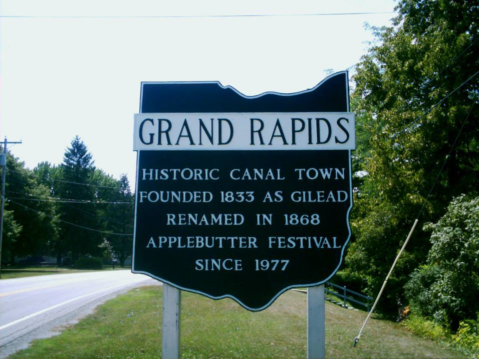
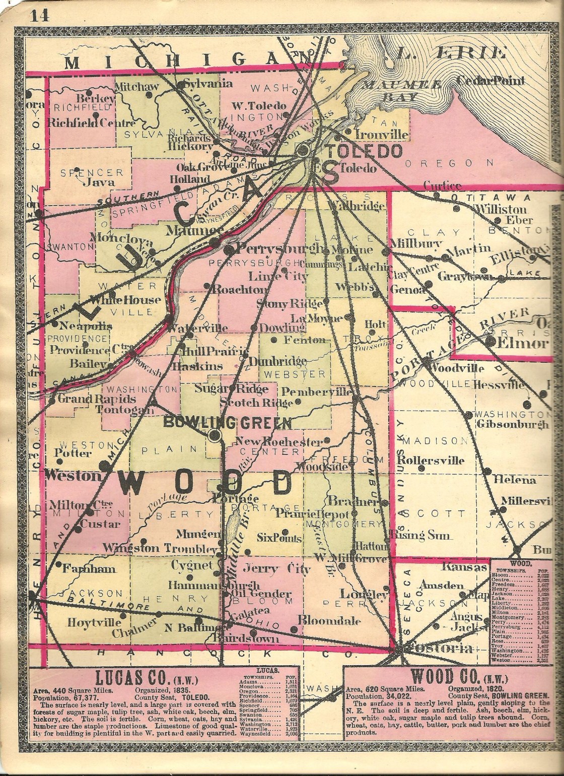
Grand Rapids, OH (Gilead) – (1833 – present farming, mill, and railroad town)
Classification: historic town
Location: Grand Rapids Township, Wood County and Providence Township, Lucas County – On SR 65 at the intersection of Wapakoneta Rd along the Maumee River
Peter Manor (1778 – 1847) settled in the area in 1816. He was a fur trader who previously operated a trading post for the Northwestern Fur Company. Peter built a saw mill in 1822 next to the Maumee River and expanded it with a grist mill in 1835. He platted the town of Providence in 1837 and had to sell off his mill to the state in 1838 during construction of the Miami & Erie Canal. Most of the 88 plats in the town, which were on five streets, were bought up and the town started to grow. Unfortunately a devastating fire swept through the business district in 1846.
Peter died the next year while in the process of rebuilding his mill. Isaac Ludwig (1813 – 1906) and his wife Christenia (Ness) Ludwig (1819 – 1903) purchased the mill and completed its construction. Providence was hit by the cholera epidemic in the early 1850s and the population decreased again. Then it lost its post office which ran from 1836 – 1868. The town never had a railroad station and the closing of the canal was pretty much the last straw for Providence. Lucas County removed it from their recording list in 1928, turning it into a ghost town at the time.
With the success of Grand Rapids on the other side of the Maumee River in Wood County, originally platted as Gilead in 1833 and changed to Grand Rapids in 1868, the Providence area was never totally abandoned. Construction of Providence Metropark and its historic nostalgia made Ludwig Mill and former canal a neat tourist attraction. Although it presently has a Grand Rapids mailing address, Providence has basically regained its separate town status since then. It’s a populated place in Lucas County for census purposes and is listed on some maps as a current town despite technically being a ghost town.
The Ludwig Mill is restored and has a general store in Providence Metropark at 13827 Old US 24 Grand Rapids, OH 43522. It’s open from May to October, Wednesday through Sunday, 10 a.m. – 5 p.m. On Sundays they do full demonstrations of the mill operations from 1 – 4 p.m. and run a canal boat that passes by the abandoned Miami & Erie Canal Lock #44. There are also some other old buildings in the Providence Historic District, including St. Patrick Roman Catholic Church built in 1845. Grand Rapids has many historic sites to check out as well. Isaac and Christenia Ludwig were buried in Mount Pleasant Cemetery on Bailey Rd off of Providence Neapolis – Swanton Rd, about 3 miles north of town.
Mill And Metropark Info – https://metroparkstoledo.com/explore-your-parks/providence/