Armenia – Belpre Township
Post Office: 1887 – 1915
Location: 39.230602, -81.707785
on Newbury Rd (State Rte 124) at the intersection of Township Rd 299
Remnants: Newberry (Newbury Community) Cemetery south of the GPS coordinates at the intersection of Newbury Rd (State Rte 124) and T502
Description: Charles Wesley Oakes (1846 – 1925) was a Feemason and the town’s postmaster. He married Lucy (Sedgwick) Oakes (1849 – 1929) and had 5 children. His paternal grandparents, Joel Oakes (1766 – 1822) and Susannah (Bent) Oakes (1771 – 1865), were from Worcester County, Massachusetts. They married in 1795, had 7 children and were early pioneers in the county. Susannah’s father was a Revolutionary War veteran and participated in the Boston Tea Party. Charles was buried with his family and other residents in Newbury Community Cemetery.
Aurelius – Aurelius Township
Post Office: 1851 – 1860
Location: 39.591276, -81.419388
on Brooms Run between SR 821 and T614 along Duck Creek
Remnants: none known
Description: Civil War veteran and Township Trustee Archibald Grubb (1833 – 1895) built a grist mill and saw mill next to Duck Creek and was the town’s postmaster. Aurelius also had a school on the opposite side of the creek on the south side of SR 821 just east of the intersection of Brooms Run. Archibald was buried in Waterford Cemetery on Sunset Ln in Waterford Township.
Barber – Warren Township
Post Office: 1852 – 1859
Location: 39.434494, -81.538553
on Christy Rd between Warren Chapel Rd and Olinn Rd
Remnants: none known
Description: This small farming and postal town had a school on the east side of T125 a mile south of the GPS coordinates. Jesse Johnson was the postmaster.
Barnett Ridge – Barlow Township
Location: 39.361668, -81.624584
on Barnett Ridge Rd (C2) between Veto Rd (C3) and Rocky Point Rd (Co Rd 27)
Remnants: Barnett Ridge Church and Cemetery at the GPS coordinates, another church on the east side of Barnett Ridge Rd about 1/2 of a mile north of the GPS coordinates
Description: Barnett Ridge had a couple of general stores and a few schools from the mid-1800s to mid-1900s. Over 60 Barnett family members have been laid to rest in the cemetery, with the most recent being Ruth (Barnett) Mayle (1918 – 2017). Ruth attended and later taught at the last school the town had. She was also a member of the Belpre Historical Society.
Big Bottom
Post Office: 1834 – 1838
Location: unknown
Description: Jesse Blackmer (1809 – 1889) and John Shrader were the postmasters. The office moved to Stockport in Morgan County. Jesse was buried with relatives in Blackmer Cemetery on the west side of SR 266 about 1/3 of a mile south of Mill Run in Windsor Township, Morgan County.
Carter – Ludlow Township
Post Office: 1899 – 1904
Location: 39.561191, -81.241743
on Township Rd 64 along Wingett Run between Township Rd 364 and Community Club Rd
Remnants: none known
Description: The town had a saw mill and a Christian church on the west side of Township Rd 64 on land owned by John Adams. A school was northeast of the GPS coordinates on the west side of Township Rd 88. William Adams was the postmaster.
Cats Creek Mills – Adams Township
Post Office: 1813 – 1817
Location: unknown
Description: It was along Cat Creek north of Upper Lowell and had a mill owned by Wheelock, Fuller, & Salder. Daniel W. Wheelock (1785 – 1853) from Massachusetts was the postmaster. He moved to Dayton and was buried with relatives in Woodland Cemetery and Arboretum on Woodland Ave in Dayton, Montgomery County.
Dye – Fearing Township
Post Office: 1883 – 1902
Location: 39.504980, -81.394913
on Whipple Run Rd at the intersection of Township Rd 329
Remnants: Berg Church and Cemetery about 1/3 of a mile southwest of the GPS coordinates at the intersection of Township Rd 329 and T332, old houses and farm buildings in the area
Description: Dye was a small farming and postal town with a school in the southwest lot of the intersection. A. M. Templeton was the first postmaster. He was succeeded by Thomas Strickling (1857 – 1936) who later moved and was buried in Fairview (Long) Cemetery on Fairview Rd in Springfield Township, Gallia County. G. F. McVay was the last postmaster. Berg Church was constructed in 1872 on land owned by German immigrants Peter Berg (1814 – 1899) and Margaretha (Moerschel) Berg (1818 – 1884). They married in Germany in 1837, moved to the U.S. in 1841, and had 11 children. Peter and Margaretha were laid to rest in the cemetery with relatives and other residents of Dye.
Gray – Liberty Township
Post Office: 1873 – 1889
Location: 39.549062, -81.332634
on Dalzell Rd (Co Rd 11) at the intersection of T606
Remnants: Waxler Church and Cemetery 1 mile southwest of the GPS coordinates at the intersection of Dalzell Rd and Stanleyville Rd (C42)
Description: It was named after the Gray family in the area and had a general store in the corner on the east side of the GPS coordinates owned by Wilford Howell (1821 – 1891) from Monroe County and Agnes (Farnsworth) Howell (1825 – 1894) from Pennsylvania. There was another store on the Howell farm next to their residence on the south side of Dalzell Rd about 1/4 of a mile southeast of the GPS coordinates. The town’s first school was also on the Howell farm. Its second school was east of Waxler Church at the intersection of Stanleyville Rd and Whipple Run Rd. Wilford and Agnes were buried with relatives in Dalzell Church Cemetery about 2 1/2 miles northeast of town on the north side of Dalzell Rd.
Henrys Crossing – Barlow Township
Location: 39.386946, -81.627024
on Stone Quarry Rd at the former railorad crossing between SR 550 and Rocky Point Rd (Co Rd 27)
Remnants: none known
Description: The original proprietors were Nathan Proctor Henry (1821 – 1875) from Ohio and Caroline Geneva (Ward) Henry (1827 – 1903) from Massachusetts. They got married in 1852, had a few children, and owned a 200-acre farm. The town was along the Marietta & Cincinnati Railroad (later bought by the B&O). Nathan was buried with relatives in Barlow Central Cemetery 2 miles northwest of the GPS coordinates on the north side of SR 550. We were unable to locate Caroline’s grave.
Hope – Decatur Township, Washington County and Rome Township, Athens County
Post Office: 1894 – 1899
Location: 39.298131, -81.814401
on Federal Rd at the 4-way intersection of Lincoln Hill Rd and Welch Rd (Co Rd 111)
Remnants: none known
Description: Hope had a blacksmith shop in the lot in the northwest corner of the intersection on land owned by William F. Johnson. Civil War veteran Truman E. Place (1849 – 1923) was the postmaster. He later moved and was laid to rest in Ohio Soldiers And Sailors Home Cemetery on Columbus Ave in Sandusky, Erie County.
Liberty Hill – Aurelius Township
Post Office: 1855 – 1865
Location: 39.592766, -81.468169
on Highland Ridge Rd (Co Rd 8) at the intersection of T116
Remnants: Liberty Hill (Hill Grove) Cemetery on top of a hill west of Highland Ridge Rd southeast of the GPS coordinates, former one-room schoolhouse on the south side of Highland Ridge Rd about 3/4 of a mile north of the GPS coordinates
Description: It was a farming town with a school and grange hall. Thomas Elison was the first postmaster. He was succeeded by Robert Bess.
Morris – Decatur Township
Location: unknown
Description: Morris was on the Marietta & Cincinnati Railroad in the late 1800s to early 1900s west of Cutler along Big Run Rd. It was listed on the Ohio map in the 1901 George Cram atlas.
Muskingum – Ludlow Township
Post Office: 1881 – 1911
Location: 39.555464, -81.222200
on T67 (Township Rd 67) along Sacket Run between SR 26 and SR 260
Remnants: abandoned road with former farm building on the east side of the GPS coordinates
Description: Robert Mulinex (1820 – 1894) and Nancy (Brill) Mulinex from Virginia (1819 – 1902) owned a packing plant on the west side of T67 near the GPS coordinates. Isaac R. Rinard (1824 – 1899) was the first postmaster. He was buried with relatives about 10 miles southeast of town in New Matamoras Cemetery on Cemetery Rd in Grandview Township. David Mulinex (1844 – 1911), a son of Robert and Nancy, was the last postmaster. The office was discontinued when he passed away. Robert, Nancy, and David were buried with relatives in Liberty (Evangelical United Brethren) Cemetery about 7 miles northwest of town on the north side of Liberty Ridge Rd.
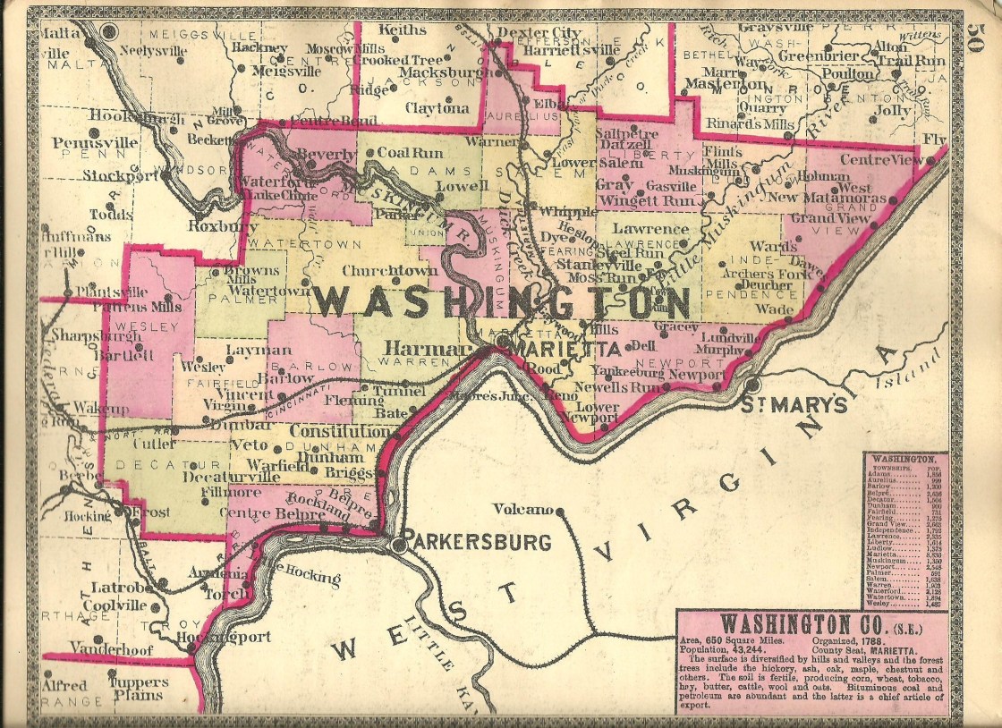
Newberry (Newberry Settlement) (Newbury) – Belpre Township
Location: 39.225109, -81.701405
on Newbury Rd (State Rte 124) at the intersection of T502 along the Ohio River
Remnants: Newberry (Newbury Community) Cemetery at the GPS coordinates
Description: Long before the Armenia post office was established in the area, and just 2 years after Marietta was founded, Newberry became one of the earliest settled places in the state. Its land stretched from around Belpre Township’s western border over to present-day Little Hocking north of the GPS coordinates. Truman Guthrie (1765 – 1841) from Litchfield County, Connecticut arrived in 1790 to clear land for himself and his father, Joseph Guthrie (1733 – 1808), who was a member of the Ohio Land Company. Truman married Elizabeth (Stone) Guthrie (1771 – 1851) from Worcester County, Massachusetts in 1796 and had 8 children. He is also credited with planting the first wheat crop in Ohio with seed obtained during a harvest Pennsylvania. Revolutionary War veteran Nathaniel Sawyer (1757 – 1813), who owned the land where Little Hocking now stands, named the Newberry Setttlement after Newburyport, Massachusetts where he lived before moving to Ohio. Nathaniel built the first corn cracker, a predecessor to 1800s grist mills, next to Sawyer Run. Newberry also had a fortified stockade, as many settlements in Ohio did before the close of the War of 1812, built for protection against Native Americans. They were a useful necessity but required both getting into them in time and successfully defending them to save settlers lives. A couple of the early recorded burials in Newberry Cemetery are that of a Mrs. Brown and Persis Dunhan who were killed in an attack on the fort on March 15, 1792. Newberry updated its name to Newbury in the mid-1800s and had a meeting house on the north side of Township Rd 299 and a school on the south side of the cemetery. Both of those were listed on the 1858 county map. The Guthrie family was laid to rest in Newberry Cemetery. Nathaniel Sawyer moved away and was buried with relatives in Pioneer Cemetery on the north side of SR 329 between Federal Creek and the Hocking River in Stewart in Rome Township, Athens County.
North Union – Wesley Township
Post Office: 1851 – 1858
Location: 39.381090, -81.834263
on Mayle Ridge Rd (C96) at the intersection of Southland Cemetery Rd (Township Rd 217)
Remnants: Southland Mission Cemetery on the west side of Southland Cemetery Rd about 1/3 of a mile south of the GPS coordinates
Description: North Union had a meeting house on the south side of Mayle Ridge Rd west of the GPS coordinates and the general store with its post office was in the lot on the east side of the GPS coordinates. Joel Gilbert (1816 – 1890) was the first postmaster. He moved out of the county and was buried in Friends Cemetery on the west side of SR 377 south of Kennard Rd in Penn Township, Morgan County just northwest of Pennsville. Thomas Bundy (1815 – 1884) was the last postmaster. He was buried with his wife Ruth W. Bundy (1813 – 1886) in Friends Cemetery about 4 1/2 miles north of town on T210 of off SR 555.
Olga – Salem Township
Post Office: 1888 – 1899
Location: unknown
Description: Olga was located near Warner. Civil War veteran William L. Gardner (1842 – 1916) from Coshocton County was the postmaster. He later moved and was buried with his second wife, Catherine (Stegner) Gardner (1852 – 1930), in Prospect Cemetery at the intersection of SR 73 and Prospect Rd in Washington Township, Highland County.
Ormiston – Barlow Township
Post Office: 1890 – 1901
Location: 39.425778, -81.620138
on Anderson Rd (C2) at the intersection of Fisher Ridge Rd (Township Rd 29)
Remnants: none known
Description: The original proprietors were James Ormiston (1768 – 1849) and Chirstina (Lamb) Ormiston (1769 – 1852). They moved to the U.S. from Scotland and settled in Barlow Township in 1831. In the mid-1800s, the town had a school in the lot on the northwest side of the GPS coordinates on land donated by James and Christina and a saw mill along South Branch Wolf Creek on land owned by the Turner family. A newer school was built on the Turner farm on the east side of Fisher Ridge Rd and was listed in the 1875 county atlas. One of the grandsons of James and Christina, Civil War Alexander Ormiston (1835 – 1927) was the town’s postmaster and operated a general store on his 90-acre farm at the GPS coordinates. He buried with relatives in Barlow Central Cemetery about 3 1/2 miles southwest of the GPS coordinates on the north side of SR 550. James and Christina were buried with relatives 2 1/2 miles south of the GPS coordinates in Old Fleming Cemetery on private property on the east side of Anderson Rd.
Palmers Settlement (Browns Mills) – Palmer Township
Post Office: 1819 – 1903
Location: 39.467608, -81.714381
on SR 676 between Buchanan Rd (C6) and Brownrigg Rd
Remnants: Palmer United Methodist Church and former town house at the GPS coordinates, Gard (Palmer) Cemetery 1 mile northwest of the GPS coordinates on Gard Cemetery Rd off of SR 676, old houses and farm buildings in the area
Description: Joseph Palmer Jr. (1761 – 1831) and Hannah (Fox) Palmer (1763 – 1836) were both born in Windham County, Connecticut and arrived in the area in 1802 along with their 5 children. In 1803, they purchased a farm at the GPS coordinates and had another daughter. Joseph became the first justice of the peace in Palmer Township and served in the state legislature. Samuel Brown (1781 – 1872) from Hampshire County, Massachusetts built a mill next to West Branch Wolf Creek for the firm of Sharp & Hunt. Samuel subsequently purchased the mill and opened the post office. The office moved from Wolf Creek to Palmers Settlement in the mid-1800s and the town took on its name. Several succeeding postmasters filled the position with the office moving around to their various residences. The local church congregation formed in 1825. Palmer United Methodist Church was constructed in 1837 on the old family homestead. It was restored in 1877 and again in 1892. The town house across from the church was built in 1891. A school next to the town house was constructed in 1856 and has since been lost to time. There were also a few general stores in the community in the 1800s, including a couple on the Palmer farm on the west side of SR 676 south of the town house. Gard (Palmer) Cemetery was established in 1817. Everyone mentioned in this listing was buried there with relatives and many pioneers from the area. The Palmer, Brown, and Gard families were all related by marriage.
Stowes – Muskingum Township (formerly in Union Township)
Location: 39.513833, -81.477126
on Muskingum River Rd (Township Rd 32) along the Muskingum River between Lowell and Rainbow
Remnants: none known
Description: James Smith Stowe (1806 – 1895) was born in Meigs County and moved to Muskingum Township at the age of 20. He started a river shipping business with flatboats in 1829, delivering local produce and goods down the Ohio and Mississippi Rivers for several decades. James also dealt in land speculation, investing around $90,000 in bottom farm lands around the area. He was married 3 times, had 11 children, and was buried with relatives 2 1/2 miles south of the GPS coordinates in Rainbow Cemetery on Rainbow Cemetery Rd.
Ward (Wards Station) – Grandview Township
Post Office: 1882 – 1907
Location: 39.499897, -81.150359
on C9 (Co Rd 9) at the instersection of T422 (Hackthorn Cemetery Rd)
Remnants: Hackathorn Cemetery at the southern end of T422, Bell Cemetery at the intersection of C9 and Ward Rd (Township Rd 421)
Description: The town was founded by James Ward (1813 – 1901) from Pennsylvania and Margaret (Leeper) Ward (1815 – 1899). They got married in 1834, had 7 children, and moved to Grandview Township in 1845. While driving through the area, or checking it out on current satellite maps, its tough to imagine there was once a rather densely populated community there. However, the 1875 county atlas and 1881 county history book confirmed its former bustling existence. A couple of James and Mararet’s sons, Albert Ward (1844 – 1919) and Joseph Ward (1846 – 1912) ran a general store on their parents land on the south side of C9 (Co Rd 9) just west of T422. Joseph served as the postmaster for the first year or so, and Albert took on the position for the remainder of its operation. There was also a tie shop (string and rope) on the east side of the store, a shoe shop on Albert’s property across the road from the store, a blacksmith shop on the east side of the shoe shop, a school on the north side of Wards Hollow Rd, and a small Union church at Hackthorn Cemetery. A Methodist church was at Bell Cemetery a mile west of the GPS coordinates at the intersection of C9 and Wards Rd. James and Margaret were laid to rest in Grandview Cemetery about 6 miles northeast of town on Grandview Hill Rd in Matamoras. Albert was buried with relatives in East Lawn Memorial Park (Valley Cemetery) on SR 7 in Reno. Joseph was buried with relatives in Oak Grove Cemetery at the intersection of 8th St and Wooster St in Marietta.
Caywood, OH (Caywood’s Station) – (1790s – present farming town with fewer residences than in the past)
Classification: small town
Location: Fearing Township, Washington County – On Caywood Rd at the intersection of Lynch Church Rd
Caywood was settled in the 1790s by William Caywood (1777 – 1864) and was named after him. It was never a big town but had a train station on the Cleveland & Marietta Railway. There was also a general store, several churches, and a post office that ran from 1871 – 1922. William is buried in Lynch Church Cemetery on Lynch Church Rd along with some of his relatives and other early families. Caywood lost a lot of residents over the years, but the area still goes by the same name.
Elba, OH – (1871 – present coal mining, farming, and railroad town partially destroyed by floods)
Classification: semi-ghost town
Location: Aurelias Township, Washington County – On SR 821 at the intersection of Elba Hill Rd (Town Hwy 278)
Elba was settled in the mid-1800s, mostly by German immigrants. It became a town in 1871 and was named by Frederick Kueck (1817 – 1876) after the island that Napoleon Bonaparte was exiled to, because they were both considered to be a “vast wilderness” at the time. Frederick donated land for a train station on the Cleveland & Marietta Railway. He also operated a general store at the Elba Station depot and was the first postmaster. The town had three general stores at its peak. Most of the residents either worked in local coal mines or were farmers. The post office ran from 1871 – 1984.
Elba was originally located on US Hwy 21, but that changed when I-77 was built nearby. Some stretches of US 21 were abandoned and Elba ended up on SR 821. Its initial population decrease occurred as Elba lost its train station and travelers passed it by on I-77. The second demise that Elba faced was a series of floods. The first and worst of those was in 1998 when it rained over 13 inches in a single day and the banks of Duck Creek severely flooded. Two more floods ravaged Elba in 2004 in one week and the last one happened just four months later in 2005.
Elba Community Church, the Castle Hall of the Knights Of Pythias, and several other homes and buildings sit abandoned on SR 821. The town population is currently the smallest it has ever been. A lot of the land and buildings were purchased by the government to be demolished, but not much of that has happened yet. Frederick Kueck was buried in Mound Cemetery in Marietta with some of his family members.
Thanks to group member Chelssie (Thompson) Hanson for providing listing lead and most of the info on Elba!
Marietta, OH – (1788 – present farming, river, and railroad town)
Classification: historic town
Location: City of Marietta, Washington County – Exits off of I-77
Marietta was founded in 1788 at the confluence of the Muskingum and Ohio Rivers as the first permanent settlement in the state, and the first U.S. settlement west of the original 13 colonies. The town quickly grew to be one of the most important in Ohio history. On top of being a river town, Marietta was a major transportation hub with several cargo and passenger railroad stations in the mid-1800s to mid-1900s.
Ohio Historical Marker #14 – 84 at 428 Fort St tells the tale of Meriwether Lewis’s arrival in the area on his way to meet up with William Clark for their great expedition of the Northwest Territory. Marker #20 – 84 at 601 Front St and the Ohio River Museum has info about the Underground Railroad on the Muskingum River. Ohio Historical Marker #11 – 84 at 601 Second St has a story about the Northwest Ordinance of 1787.
There are also a ton of historical buildings in Marietta including the Anchorage House on Putnam Ave. It was built in 1854 – 1859 and is said to be haunted by the ghost of Eliza (Whipple) Putman (1809 – 1862) who lived there and hosted lavish parties. Another interesting home, The Castle, is now on the National Register of Historic Places. It was built in 1855 and purchased by John Newton Esq. who was the owner of the Marietta Bucket Factory. The Castle is supposedly haunted by the ghost of Jessie (Davis) Lindsay. She lived there 85 years and died in 1974. It opened for tours in 1994. The Lafayette Hotel and a few other buildings also have reported hauntings.
Porterfield, OH (Bents) (Centre Belpre) (Center Belpre) – (1830 – present mill and railroad town)
Classification: small town
Location: On SR 339 at the intersection of Railroad St (Railroad Ave)
Porterfield’s history dates back to the early 1800s. The first action that turned the hamlet into a town was the opening of Bents (Bent’s) post office which ran from 1830 – 1837. Nahum Bent was born in 1778 in Massachusetts, a son of Revolutionary War veteran Lieutenant Silas Bent (1744 – 1818) and Mary (Carter) Bent (1747 – 1831). He married Susan (Dilley) Bent from Virginia in Marietta in 1810 and had a few children. Nahum and Susan likely moved out of the state, as it appears we located Susan’s gravestone in Foultz Cemetery in a patch of woods on the east side of Co Rd 68 in Andrew County, Missouri. Her death year was recorded as 1846.
Bents post office moved to the house of Dr. George N. Gilbert (born c. 1790 – 1870) and Lucy (Putnam) Gilbert (1804 – 1894) and took on the name of Centre Belpre. The Gilberts owned a farm along Davis Creek on Drag Strip Rd on the east side of town and were buried with relatives and other residents of Porterfield in Rockland Cemetery on the south side of SR 32 (SR 7) on the east side of town. George held the postmaster position for about 30 years. After he passed away, Parker Lewis (1827 – 1891) was appointed postmaster.
Parker was nearly a lifelong cripple. His right knee was badly damaged in a “coasting” accident at the age of 4. We’re assuming “coasting” refers to the early form of cycle and board riding in the days before pedals and brake systems. Parker had his leg amputated after his marriage to Elizabeth (Pickering) Lewis (1828 – 1918), though he continued to have a great deal of pain with what is now diagnosed as phantom limb syndrome. Parker and Elizabeth owned a general store in the southeast corner of the intersection of SR 618 (Washington Blvd) and SR 339. Parker was the postmaster for about 16 years and the township treasurer for 14 years. The Parkers were born in Harrison County, had at least 6 children, and were also laid to rest in Rockland Cemetery.
Joseph C. McKee was the last postmaster of the Centre Belpre office. It changed to Center Belpre in 1893 with Harrison M. Yates (1849 – 1929) serving as the first known postmaster of the office of that name. By that time, the B&O railroad had been rolling through the area for a couple of decades. The town had a train station and its most iconic business, the Porterfield Milling Company, had a spur off the railroad leading to the site for easy transport of its goods. We couldn’t pinpoint the exact year when the town took on the name of Porterfield, but it was sometime between publication of the 1875 county atlas and the 1901 George Cram atlas.
Porterfield’s former schools on School House Rd (T15 / Township Rd 15), a couple of one-room schoolhouses, were destroyed by an arson fire in 1936. They were replaced later that year with a brick structure. It was the last operating public one-room schoolhouse in the county and closed in 1960. The building is presently a community center in the southeast corner of the intersection of School House Rd and Hamrick Ln. The post office kept the name of Center Belpre until it was discontinued in 1959. Shortly after that, the town was basically geographically split across the middle with the introduction of the 4-lane SR 32 (US 50 / SR 7). Porterfield lost some historic land and buildings in the process, as the modern highway, along with access ramps, was much wider than the old road previously was.
Thanks to Stephen Self for providing the listing lead on Porterfield!
Rainbow, OH – (1795 – present early Ohio River town with little growth)
Classification: small town
Location: Muskingum Township, Washington County – On Muskingam River Rd (Town Rd 32)
In 1795 some settlers from Marietta drew lots for 27 plats of land near the mouth of Rainbow Creek. The creek and town were named for the rainbow shaped route that the Muskingum River takes through the area. Revolutionary War veteran Isaac Stone (1749 – 1808) and Lydia (Barrett) Stone (1751 – 1792) were the first to move there and had several children, but later got divorced and both remarried. They were followed by the Stacy family and several other families that won plats.
Ship building, mills, and farming were the main sources of income in Rainbow. During the Civil War, many of the residents went to fight for the Union Army. Thomas Ridgeway, an avid abolitionist, helped nearly 100 slaves escape to freedom on the Underground Railroad at his house by the river. The town had a train station on the B&O Railroad and a post office that ran from 1888 – 1903. Issac Stone and other early residents are buried at Rainbow Cemetery on Rainbow Cemetery Rd (Township Rd 513).