

Featuring 5 towns with 12 pictures from Warren County, Restored Ohio was released on April 29, 2019. It’s the sequel of Abandoned Ohio (2018) and shows a different side of what physically remains of Ohio’s past. Many of the locations operate as businesses such as restaurants, hotels (former stagecoach stops), museums, and working mills.
Ordering Links
Arcadia Publishing – https://www.arcadiapublishing.com/Products/9781634991216
Amazon – https://www.amazon.com/Glenn-Morris/e/B07G8N3HP2/ref=ntt_dp_epwbk_0
Barnes & Noble – https://www.barnesandnoble.com/w/restored-ohio-glenn-morris/1129901378?ean=9781634991216
Walmart – https://www.walmart.com/ip/Restored-Ohio/185272799
Target – https://www.target.com/p/restored-ohio-by-glenn-morris-paperback/-/A-78016964

Baltimore (New Baltimore) – Wayne Township
Location: 39.541903, -83.986786
on hiking trails in Caesar Creek State Park off of New Burlington Rd
Remnants: Caesars Creek Cemetery north of the GPS Coordinates at the end of an abandoned section of New Burlington Rd
Description: Joshua Canby (1801 – 1864) and Esther (Lownes) Canby (1803 – 1877) from Maryland were married there in 1823 and later moved to Ohio. They were the first known owners of the grist mill and saw mill site at New Baltimore along Caesars Creek in eastern Wayne Township, naming the town after the most prominent one in their home state. Joshua and Esther moved to Iowa in the mid-1830s and along with most of their children. They were buried in Friends Cemetery in Henry County, Iowa on the west side of Lexington Ave between 120th St and SR 78 (130th St). Back in Ohio, James Spray (1793 – 1880) and Charity (Sanders) Spray (1794 – 1866) were the next known owners of the mill site. They moved to Ohio from South Carolina and had 6 children. James and Charity were buried in Springfield Friends Cemetery at 121 Todds Fork Rd in Adams Township, Clinton County. John Stanfield (1820 – 1899) and Mary Stanfield (1826 – 1906) were the last owners of the mill site. The grist mill had been abandoned by the 1880s and but the Stanfield family continued to operate a saw mill at the historic location. John and Mary were also buried with relatives in Springfield Friends Cemetery. Some of the other residents of New Baltimore were laid to rest in Caesars Creek Cemetery.
Butterworth (Butterworth Station) – Hamilton Township
Location: 39.303441, -84.247777
on Sibcy Rd at the intersection of Butterworth Rd
Remnants: Butterworth Stone House on Sibcy Rd west of Butterworth Rd, Butterworth Farm wood frame house on the north side of Sibcy Rd just east of the stone house, Butterworth Farm (Foster) Cemetery on private property on the south side of Sibcy Rd on top of the hill overlooking the valley, historical marker at the site of Butterworth station along the Little Miami Scenic Trail
Description: Benjamin Butterworth (1766 – 1833) and Rachel (Moorman) Butterworth (1765 – 1848) got married in 1786, moved to Ohio from Virginia in 1812, and had 11 children. They were also members of the Quaker Society Of Friends, abolitionists, and freed the family’s slaves before leaving Virginia. Loveland was later platted on a 500-acre farm which Benjamin and Rachel purchased. Another large farm in Hamilton Township, the subject of this sketch, became the family’s home. A few of the Butterworth’s children settled on the land in the mid-1810s and Benjamin and Rachel built a modest stone house on the hill above a valley next to the Little Miami River. It was completed in 1820. Henry Butterworth (1809 – 1893) and Nancy (Wales) Butterworth (1809 – 1909) from North Carolina inherited the stone house. They were married in 1830, donated land for a train station on the Little Miami Railroad in the early 1840s, and were also abolitionists, hiding and feeding runaway slaves traveling along the Underground Railroad. A water tower on the farm was used as a waiting station for the town’s flag stop on the Little Miami Railroad. The stone house received a few additions over the centuries and was restored by Butterworth descendants who still own the property. A large wood frame house on top a hill close to the stone house was also built by the Butterworth family. Everyone mentioned in this listing was buried in Butterworth Farm Cemetery.
Little Miami Scenic Trail Info – https://www.miamivalleytrails.org/trails/little-miami-scenic-trail
Edgewood – Clearcreek and Wayne Township
Location: 39.545957, -84.136792
on SR 73 at the intersection of Township Line Rd (Co Hwy 134)
Remnants: old houses and farm buildings in the area
Description: Edgewood was on the Dayton, Lebanon, & Cincinnati Railroad in the late 1800s to early 1900s. It had a school on the north side of SR 73 west of the GPS coordinates on land donated by Wallace Tibbals (1841 – 1911) and Adella (Stokes) Tibbals (1843 – 1934). They got married in 1867, had a few children, and were buried with relatives 4 miles southeast of town in Miami Cemetery on the south side of Corwin Ave (Co Hwy 244). The railroad tracks have since been removed, but portions of its path can be seen on satellite maps.
Fredericksburg – Salem Township
Location: 39.357589, -84.128778
on SR 123 at the intersection of Mason Morrow Millgrove Rd (Co Rd 38) along the Little Miami River across from the mouth of Todd’s Fork
Remnants: former one-room schoolhouse on the south side of Mason Morrow Millgrove Rd (Co Rd 38) about 1/4 of a mile west of the GPS coordinates, old houses and farm buildings in the area
Description: Originally in Union Township, Fredericksburg was platted with 14 lots by Nathan Hale in 1818, but it never grew much due to the continual threats of flooding. However, all of the platted lots were eventually sold. Alexander Crawford and T. J. Snyder ran competing general stores and the town did benefit from a good amount of trade with its strategic placement. It had a school, which can be spotted in the 1875 county atlas. There were 52 residents in 1880 and Fredericksburg was never completely abandoned, although it lost the status of a being a town sometime in the early 1900s. The former school has been beautifully converted to a private residence.
Thanks to Lori Cook for providing the location info on the school!
Gainesboro – Deerfield and Hamilton Township
Post Office: 1822 – 1827
Location: 39.355551, -84.245801
on King Ave at the intersection of Church St along the Little Miami River
Remnants: none known
Description: Gainesboro was platted by Ralph W. Hunt with 134 lots in 1815 at the present location of Kings Mills. Jacob Reeder was the town’s postmaster. The population climbed to around 150 residents with a wool mill and carding mill. A canal was intended to be built through the area, but it never ended up happening. As a result, residents moved away and the town nearly completely died out a couple of decades prior to the establishment of Kings Mills in 1884. The first mill in the county was built around 1799 by William Wood on the grounds of what would later become Kings Powder Plant (Peters Cartridge Company).
Glenwood – Turtlecreek Township
Location: 39.412581, -84.292125
on Hamilton Rd (Co Hwy 13) along Station Creek and the railroad tracks between Mason Montgomery Rd and SR 741
Remnants: none known
Description: Glenwood was on the Cincinnati, Lebanon, & Northern Railway in the late 1800s to early 1900s. The residential section of town was east of the GPS coordinates near the intersection of Hamilton Rd and SR 741 where there are still houses, but none of them appear to be from the time period of Glenwood.
Hammel – Washington Township
Location: 39.378284, -84.090651
on Strout Rd (Township Hwy 207) beteween Senior Rd and Woodward – Claypool Rd along the Little Miami River & Little Miami Scenic Trail
Remnants: old houses and farm buildings in the area
Description: The town was platted about 1844 when the Little Miami Railroad arrived in the area and was founded by a member of the Hammel family. It was a farming town with very good soil in its 100 acres of bottom lands next to the Little Miami River, as occasional floods left behind nutrient-rich dirt. Hammel had a school north of the GPS coordinates on the east side of Senior Rd that was also used for church services of various congregations. The town fell off of maps in the early to mid-1900s.
Kitchener (Kirbys) – Clearcreek Township
Location: 39.507643, -84.159877
on Utica Rd between Pekin Rd and E Lower Springboro Rd
Remnants: none known
Description: Its unknown when the town was referred to as Kitchener. In the late 1800s to early 1900s the location had a flag stop called Kirbys on the Dayton, Lebanon, & Cincinnati Railroad, named after its proprietors Wilson Kirby (1842 – 1909) from Montgomery County and Margaret (Throckmorton) Kirby (1843 – 1925). They were buried with relatives in Miami Cemetery 6 miles east of town on the south side of Corwin Ave (Co Hwy 244).
Lockport (Millgrove) – Salem Township
Location: 39.378711, -84.093403
on Gilmour Rd (Township Hwy 92) at the intersection of Stroud Rd along the Little Miami River
Remnants: none known
Description: Lockport had its beginnings in the early days of Union Township before the county did some reorganizing. The town had a grist mill, general store, saw mill, and a paper mill which employed many temporary and long-term residents. After construction of the Warren County Canal was completed, connecting to the Ohio & Erie Canal in 1845, Lockport couldn’t compete with businesses along the canal and quickly began losing its population. Its name changed Millgrove prior to publication of the 1856 county map and the town didn’t last much longer after that.
Mounts Station – Hamilton Township
Location: 39.363964, -84.188669
on private property between Zoar and the Little Miami River along the Little Miami Scenic Trail
Remnants: none known
Description: William and Catherine Mounts settled in northern Hamilton Township between present-day Zoar and the little Miami River in 1795. They founded Mounts Station along with a few other families and built their cabins in a circle around a spring, which is now long gone. In Ohio’s early days before the existence of trains and railroads, station was another term for a settlement and often accompanied the building of some type of fortification such as a blockhouse. There was, however, no fortification at Mounts Station. William P. Mounts Sr. (1823 – 1886) and Henrietta (Van Duzen) Mounts (1845 – 1912) were married in 1865 and owned the land in the later 1800s.
Penquite – Washington Township
Location: 39.375534, -84.008700
on SR 132 between Gum Grove Rd and SR 133
Remnants: Union Church and Cemetery on the north side of Todd’s Fork at the intersection of Gum Grove Rd and Fordyce Rd (Township Hwy 211)
Description: The Penquite family moved to Ohio from Virginia with several members settling in Washington Township in the early 1800s. They accumulated over 400 acres of land on the southeast side of Todd’s Fork. Union Church began with a log structure on the site built by the local Baptist congregation in 1811. It was replaced with a wood frame building constructed by Methodists in 1842 and the current church was completed in 1883. The last congregation disbanded around 2007. Unfortunately, the cemetery had fallen into disrepair, but it has been fixed up by the efforts of Bob Hackman and his daughter Maryruth Cupp. They repaired and cleaned many of the stones, including some which were found under the surface. A couple dozen members of the Penquite family were laid to rest in the cemetery. Gum Grove Rd formerly crossed Todd’s Fork with a bridge that has been lost to time. There was also a church called Leather Ear in the northeast corner of the intersection of Gum Grove Rd and SR 132 and a school across the road on the south side of SR 132.
Stokes – City of Mason (formerly in Union and Deerfield Township)
Location: 39.377407, -84.288389
on SR 741 at the intersection of Bethany Rd (Co Hwy 59)
Remnants: none known
Description: Stokes had a train station on the Cincinnati, Lebanon, & Northern Railway in the late 1800s to early 1900s.
Venable – Clearcreek Township
Location: 39.527617, -84.146027
on E Lower Springboro Rd between Township Line Rd (Co Hwy 134 and Utica Rd
Remnants: none known
Description: This small farming town was founded by William Venable (1798 – 1871) from Burlington County, New Jersey and Hannah (Baird) Venable (1802 – 1875) from New York. They had a few children and a farm on the south side of E Lower Springboro Rd at the GPS coordinates. William was buried in Old School Baptist Church (Clear Creek) Cemetery a little over 2 miles northwest of the GPS coordinates behind a house on the east side of SR 48 between E Lower Springboro Rd and SR 73. Hannah moved to Minnesota after William passed away.

Franklin, OH – (1796 – present farming, canal, and railroad town)
Classification: historic town
Location: City of Franklin, Warren County – On SR 73 along the Great Miami River
Founded in 1796 by pioneer and politician General William Schneck (1773 – 1821) from New Jersey, Franklin has grown well since its beginning and presently has about 11,800 residents. William married Elizabeth (Rogers) Schneck (1776 – 1853) in 1798 and had 10 children. The family moved to Franklin in 1803. William was a militia general in the War of 1812 and a board member of the Miami Exporting Company, Ohio’s first chartered bank. He also founded Newark and Toledo. Throughout his political career, William helped propel the Ohio & Erie canal from an idea into reality. He was appointed to a commission of three surveyors who charted the future canal’s path.
Unfortunately, William contracted malaria during the canal surveying trips, turning one of his crowning achievements into his eventual demise. His family continued to have success and influence in Franklin though, including his brother John. Postal records are an integral part of researching current and former towns. The Old Log Post Office on S River St in Franklin is the oldest existing one in Ohio. John Schneck (1778 – 1867) and Sarah (Tapscott) Schneck (1787 – 1842) had 12 children and opened a general store at their two-story cabin in 1802. It became the town’s post office in 1805 and was added to the National Register of Historic Places in 1976.
Franklin’s location along the Great Miami River and Ohio & Erie Canal made it a perfect place for many kinds of business opportunities and industries. Both farming and manufacturing drove the economy and attracted a couple of railroads. The town’s Cleveland, Cincinnati, Chicago, & St. Louis (Big Four Railroad) train station was built in 1872. It has undergone some restoration over the years and is at the corner of S Main St and E 6th St. There are numerous other historical sites around town and the occasional mural with picturesque scenes of the areas earlier days. Woodhill (Franklin) Cemetery was established in the 1850s on Hamilton – Middletown Road.

Henpeck, OH (Wellman) – (early 1800s – late 1800s pioneer town abandoned for unknown reasons)
Classification: ghost town
Location: Massie Township, Warren County – On Pioneer Village Rd in Caesar Creek State Park
Quaker immigrants Levi Lukens (1767-1860) and Elizabeth Lukens (1763-1831) moved from Pennsylvania to Ohio in 1807. They settled in their cabin just south of Caesar Creek on January 1, 1808 and had 7 children. The family’s cabin and barn are restored and in what is now called Caesar’s Creek Pioneer Village. Henpeck was a small town with about 13 buildings and a saw mill and fulling mill on Caesar Creek. It was last seen in the 1891 Warren County Atlas, but hasn’t been found on any later maps.
The community of Wellman started up just a mile south around the time Henpeck was abandoned. Henpeck’s post office closed in 1894 and Wellman’s opened the same year. The postmasters over the years were Issac J. Cozzard, William E. Warwick, John A. Sears, and W. T. Jordan. Its residents likely moved to get away from areas that flooded frequently, long before construction of Caesar Creek Lake in the early 1970s.
The restored frontier town on Pioneer Village Road was established in 1973. It has a couple dozen historic buildings from the Caesars Creek area, including a general store, blacksmith shop, school, sugar shack, and the Collett’s Cabin from Jonah’s Run in Clinton County. The village is accessible year round for exploring outside, and the buildings get opened for festivals and events. Levi and Elizabeth Lukens were buried with relatives in Massie Township (Henpeck / Wellman) Pioneer Cemetery on the north side of Oregonia Road.
Pioneer Village Website – http://caesarscreekpioneervillage.org/
Waynesville, OH (1796 – present farming and stagecoach stop town)
Classification: historic town
Location: Wayne Township. Warren County – On US 42 at the intersection of North St
Waynesville was founded by Quaker settlers in 1796 and was named after Revolutionary War veteran General “Mad” Anthony Wayne (1745 – 1796). Their journey by flatboat from Philadelphia over to Columbia in Hamilton County, Ohio and then up to Waynesville was documented by their guide Francis Bailey (1774 – 1844), an English scientist, astronomer, and adventurer. His book “Journal of a Tour in the Unsettled Parts of North America” was posthumously published in 1856. The Hammel House Inn at 121 S Main St began with a log cabin called the Hammel House Stand around 1800. It was rebuilt with a wood frame structure in 1817. The bricks section was added in 1822.
The building was renovated into apartments in the mid-1900s and turned into a bed and breakfast with a restaurant and gift shop in the 1980s. It’s reportedly haunted by several ghosts, including a black shadowy figure said to have passed through the wall from room #2 into room #3 where a guest was staying. The Waynesville Engine House and Lockup at 260 Chapman St was built in 1881 as the town’s first fire station. An addition in the back was constructed in 1886 and used for the jail. It was added to the National Register of Historic Places in 1999 and was up for sale when we visited.
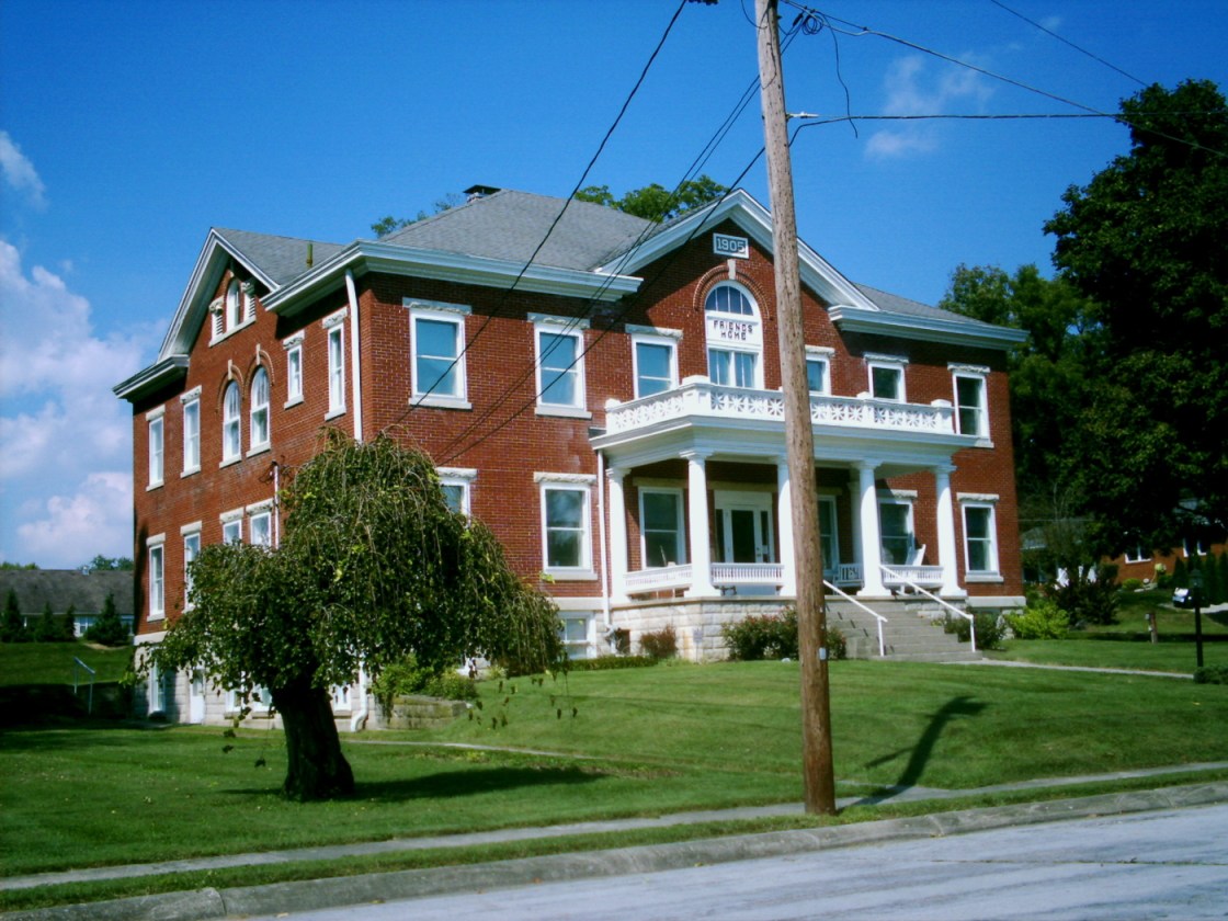
Over on S 4th St. at the intersection of Miami St., the Museum At The Friends Home is another very impressive structure. It was built in 1905 by the Quaker’s Society Of Friends and was a boarding house for retirees and single teachers. The building is considered to be the gateway to the Quaker Historic District in Waynesville. The museum is open 1 p.m. – 5 p.m. on Wednesdays and Saturdays from April to December. Tours for the Quaker Meeting House, constructed in 1811 next to the museum are also available.
Town Website – http://villageofwaynesville.org/

