Bee – Harrison Township
Post Office: 1888 – 1903
Location: 39.248924, -82.658529
on Ponetown Rd at the intersection of Thompson Rd
Remnants: none known
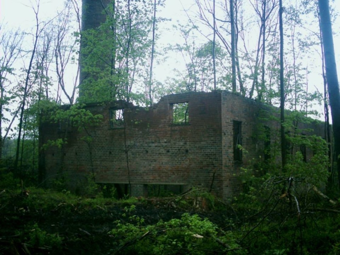
Description: The town had a one-room schoolhouse and a cooper shop on the south side of Ponetown Rd just west of the GPS coordinates owned by Bernard Hampshire (1829 – 1877) and Angeline (Humphrey) Hampshire Graves (1845 – 1920). She remarried after Bernard passed away. They were buried with relatives in Fairview Cemetery about 1 1/2 miles south of the GPS coordinates in Fairview Cemetery on the west side of Fairview Rd. The town’s postmaster was Samuel Smiley Duffy (Duffee) (1863 – 1940) from Hocking County. He later moved to Franklin County and was buried with relatives in Greenlawn Cemetery on Greenlawn Ave in Columbus.
Bolins Mills (Bolens Mills) – Knox Township, Vinton County (formerly in Athens County)
Location: 39.231988, -82.291295
on US 50 at the intersection of Staneart Hollow Rd along Raccoon Creek
Remnants: Weaver Chapel and Cemetery about 1 1/4 miles southeast of the GPS coordinates on the east side of Weaver Church Rd
Description: It was originally in Athens county and was founded by William Bolen (1788 – 1849) and Susan Bolen (d. 1854). William was a farmer and built a grist mill and saw mill next to Raccoon Creek near the end of Bolins Mills Rd (Twp Hwy 25) north of the GPS coordinates. The last known owners of the mills were Fisher & Skelly. A general store was in the northwest corner of the pinpointed intersection. There was also a school 1/3 of a mile east of the GPS coordinates in the northeast corner of the intersection of US 50 and SR 356 on land owned by the Lentner family. William and Susan were buried with relatives and other residents in Weaver Chapel (Bolins Mills) Cemetery. The town existed for around 100 years and didn’t fade into obscurity until well into the 1900s.
Cintra – Swan Township
Post Office: 1882 – 1885
Location: 39.354188, -82.448846
on Shurz Rd between SR 93 and Old Shurz Rd
Remnants: Prose Cemetery in the woods 1 mile northwest of the GPS coordinates on the east side of SR 93
Description: Cintra had a train station on the Columbus, Hocking Valley, & Toledo Railroad. The Prose family was the most prominent in the area, with Reverend John R. Prose (1821 – 1909) being the town’s postmaster. He attended Wesleyan University, was a Freemason, and preached in the Methodist Church that was on Bethel Rd. John had 4 children and was buried with his wife Clarrissa (Johnson) Prose (1829 – 1870) in Bethel Cemetery about 2 miles southwest of the GPS coordinates on the north side of Bethel Rd off of SR 93.
Cox – Eagle Township
Post Office: 1885 – 1914
Location: 39.299612, -82.740790
on SR 327 along Pike Run between SR 671 and Eagle Mills Rd
Remnants: none known
Description: The proprietors were brothers John Cox (1858 – 1906) and Abraham Cox (1852 – 1907). It had a grist mill near the GPS coordinates on Pike Run. Abraham was the town’s first postmaster. Although the office was only open for a couple of decades, at least 5 more citizens succeeded Abraham in the postmaster position. John was buried with relatives in Mount Zion Church Cemetery 14 miles southeast of town on the south side of Mt. Zion Rd between Martindill Rd and Reynolds Rd. Abraham was buried with relatives in Hamden Cemetery a little over 20 miles southeast of town on the east side of SR 93 south of Hamden.
Ego – Harrison Township
Post Office: 1889 – 1903
Location: unknown
Description: Ego was in southwestern Harrison Township between Ratcliffburg and West Junction in Jefferson Township, Ross County. George Perkins was the first postmaster from 1889 – 1892 and Phillip Arganbright held the office until it was discontinued.
Fairview – Harrison Township
Location: 39.229378, -82.672695
on Fairview Rd at the intersection of Benson Rd
Remnants: Fairview Church and Cemetery on the west side of Fairview Rd north of the GPS coordinates
Description: The town was named after Fairview Ridge on the west side of the intersection. It had a school on land owned by the Domeny family on the east side of Fairview Rd north of the GPS coordinates between Hutt Rd and Ponetown Rd. Fairview Church was constructed in 1867 on land donated by Jacob Hill (1827 – 1893) and Phoebe (Sines) Hill (1825 – 1892). They were married in 1848, moved to Vinton from Guernsey County, and had 11 children. The church started out with a United Brethren congregation and later switched to United Methodist. Residents used Bee post office on Ponetown Rd in the late 1800s to early 1900s. Jacob and Phoebe were buried with relatives in Salt Spring Cemetery about 5 miles north of town on the east side of Kelly Rd along Middle Fork Salt Creek.
Goosetown – Jackson Township, Vinton County and Benton Township, Hocking County
Post Office: 1902 – 1905
Location: 39.371166, -82.605684
on Macedonia Rd at the intersection of Lowery Rd (Township Rd 234)
Remnants: Chestnut Grove Church and Cemetery at the GPS coordinates
Description: It was named after Goose Creek just to the east of the intersection along Goose Creek Rd. Chestnut Grove Church was built on land owned by Zachariah Jewell (1842 – 1922) and Olive (Edington) Jewell from Morgan County. They were married in 1861 and had at least 6 children. There was also a steam-powered saw mill along Goose Creek across the border in Benton Township, Hocking County owned by David Stokley. Zachariah and Olive were buried with relatives in the cemetery.
Ingham (Ingham Station) – Brown Township, Vinton County and Waterloo Township, Athens County
Post Office: 1903 – 1904
Location: 39.311475, -82.300541
on the former railroad path between Rockcamp Rd and Hope – Moonville Rd
Remnants: electric poles lining the former railroad path, mine shaft entrances, and mining tools on hiking trails off the former railroad path
Description: The town was between Moonville and Kings Station on the Marietta & Cincinnati Railroad (later bought by the B&O). It’s about a 1 1/3 mile hike on the former railroad path from both Moonville Tunnel and Kings Hollow Tunnel with comparable difficulty in making the creek crossings where the train trestles have since been removed. Ingham was founded in 1856 by brothers W. J. and J. M. Ingham. It had a school, general store, train station, coal tipple, and several residences scattered about the area along with a few buildings and structures for the mining industry. The mail went through Kings Station post office from 1865 until it was discontinued in 1894. Ingham had its own office from 1903 – 1904 with William M. Jaynes serving as the postmaster. The town was abandoned around 1914 shortly after the mines closed. Trains continued to roll through the area until the railroad line, owned by CSX at the time, was officially abandoned in 1987 and the tracks were disassembled the following year. There are some foundations, mine shaft entrances, and other remnants along the hiking trails off of the railroad path.
Ox – Richland Township
Post Office: 1869 – 1904
Location: 39.246054 -82.622732
on Kelly Rd along Kelly Branch between Headley Rd (Township Hwy 2) and Carpenter Rd (Co Hwy 31)
Remnants: Antioch Church at the intersection of Kelly Rd and Carpenter Rd, old houses and farm buildings in the area
Description: Ox had a school south of the church on the wast side of Kelly Rd. The town’s first postmaster was Civil War veteran Eli Graves (1838 – 1921). He married Martha (Nichols) Graves in 1861 and had 8 children. Eli served in the Ohio Volunteer Infantry and was shot in a thigh and captured at the Battle Of Bull Run in Virginia. He was subsequently released by his surgeon at Camp Chase. Eli and Martha were buried with relatives in Salt Spring Cemetery about 2 miles north of the GPS coordinates on the east side of Kelly Rd just south of US 50. Hiram Remy Jr. (1860 – 1937) was the last postmaster. He was buried with relatives in Bell (Allensville Cemetery) on the west side of Goosecreek Rd (Co Hwy 18) on the north side of Allensville.
Pincher – Vinton Township
Post Office: 1898 – 1904
Location: 39.195304 -82.331287
on Union Ridge Rd (Co Hwy 6) at the intersection of Maynard Rd (Township Hwy 21)
Remnants: none known
Description: George Davis (1854 – 1929) was the postmaster. He married Hannah (Triplett) Davis (1851 – 1920) in 1879 and had a few children. George was buried with relatives in Harkins Chapel Cemetery 4 miles north of town on the north side of Harkins Chapel Rd in Knox Township.
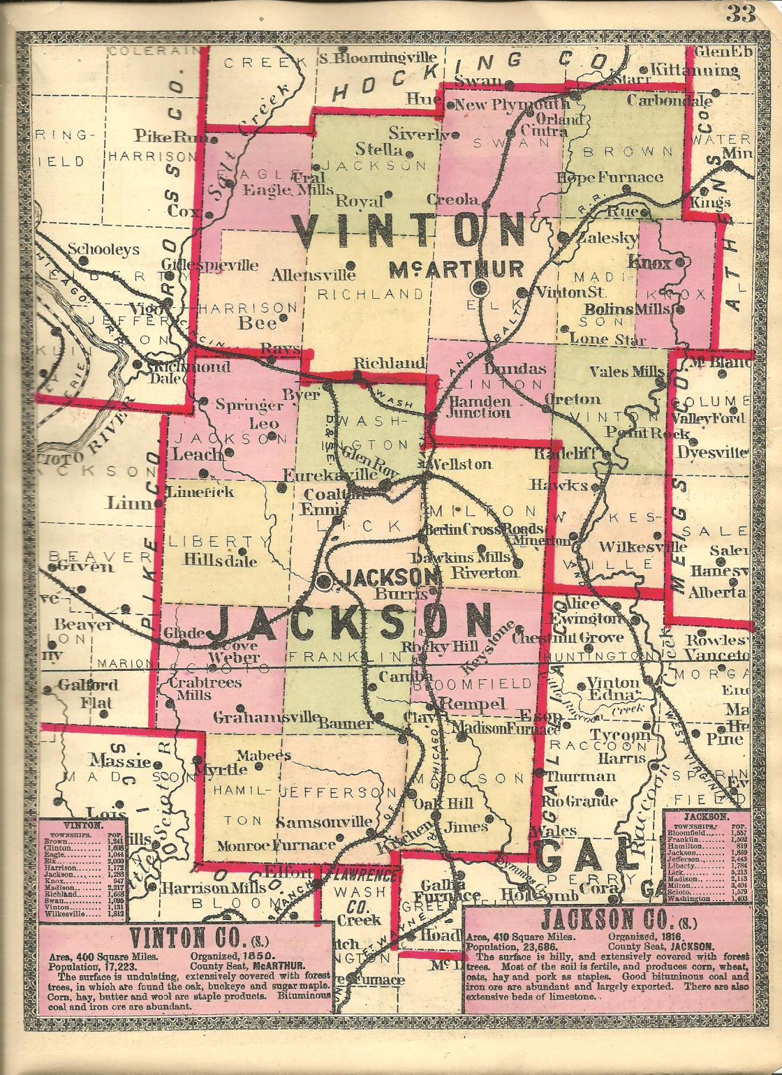
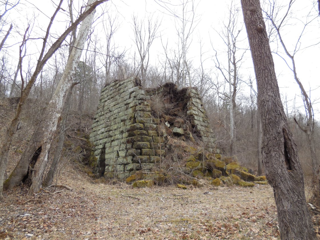
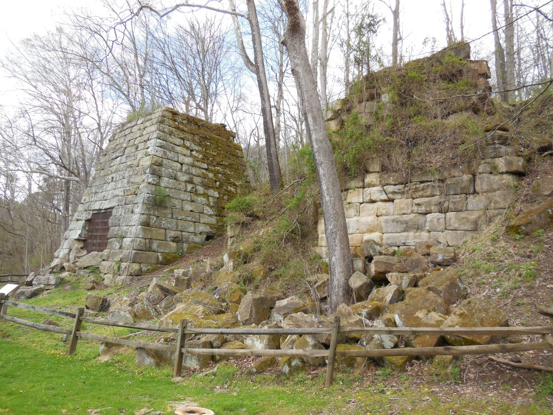
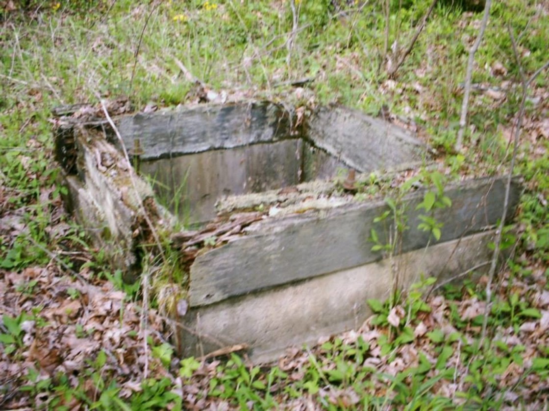
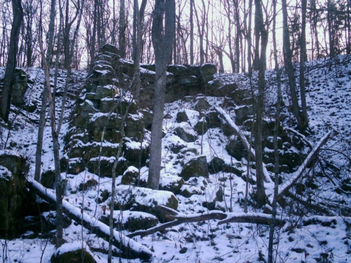
Richland (Richland Furnace) – Richland Township, Vinton County and Washington Township, Jackson County
Post Office: 1872 – 1886 and 1888 – 1914
Location: 39.186533, -82.596500
on hiking trails off of Richland Furnace Rd in Richland Furnace State Forest
Remnants: Richland Furnace at the GPS coordinates, Richland Tunnel on the railroad tracks, dilapidated former town buildings in the area
Description: It’s one of the most remote ghost towns in the state, but visiting is well worth the effort it takes to get there. The town was originally called Agatha and was in Jackson County prior to 1850 when Vinton County was formed. Its post office by that name ran from 1856 – 1871. Richland Furnace, called The Cincinnati Furnace before it’s name changed, was in operation from 1854 – 1884 and had a train station on the Marietta & Cincinnati Railroad (later bought by the B&O). Richland Tunnel is much like Kings Hollow Tunnel across the border in Athens County. They were both built with wood in 1855. Kings Hollow Tunnel isn’t in use anymore as the tracks were removed in the late 1980s, but Richland Tunnel is still active with trains. Bristol Tunnel, located on private property in Perry County, was also made with wood in 1871 – 1872. Its tracks were removed long ago and the tunnel was sealed up with concrete. They are the only 3 wooden railroad tunnels still known to exist in Ohio. As with most iron furnaces in Ohio, Richland’s production stopped when the iron supply dwindled to the point of extraction costs becoming too expensive and importing iron from other places wasn’t a viable option. The town had a school north of the furnace on the east side of what was once the southern end of what Google Maps has listed as Wilbur Rd. It’s presently inaccessible to vehicle traffic. Company buildings and residences lined the railroad tracks and Wilbur Rd. Richland Tunnel is along the tracks just southwest of the GPS coordinates. There are also some foundations, dilapidated buildings tied to the town, and other remnants around the area.
Riley (Rileyville) – Richland Township (formerly in Jackson County)
Post Office: 1827 – 1840
Location: 39.267517, -82.584458
on US 50 at the intersection of SR 683 along Riley Run
Remnants: Redfern (Redfearn) Family Cemetery on the southwest side of the GPS coordinates across Riley Run
Description: James Redfearn (1793 – 1839) from Randolph County, North Carolina was the town’s postmaster. He was buried with relatives in Redfern Cemetery.
Sant – Eagle Township
Post Office: 1888 – 1905
Location: unknown
Description: Sant was located in northeastern Eagle Township on roads east of Lady Run Rd that are now mere shadows of what they once were. The town had a school and the post office. That was pretty much it. John Turner (1853 – 1936) was the first postmaster, then Milton Sowers (1859 – 1923) for a few months in 1890. One of John’s brothers, Elisha Turner (1862 – 1928) was the last postmaster from October 1890 until it was discontinued. John and Elisha were buried with relatives in Lebanon Cemetery on the north side of Pretty Run Rd between Narrows Rd and Riddle Rd. Milton was buried with relatives in Chestnut Grove Cemetery at the intersection of Macedonia Rd and Lowery Rd (Township Rd 234) in Jackson Township.
Sheldon – Richland Township
Post Office: 1889 – 1904
Location: unknown
Description: Sheldon was in southeastern Richland Township and had a school and a baseball team. Milton Cox (1867 – 1944), buried in Elk Cemetery on SR 93 on the north side of McArthur in Elk Township, was the first postmaster. Harvey Cox (1860 – 1946), buried in Zion Cemetery at the intersection of SR 324 and Zion Rd in Clinton Township, was the second postmaster. Timothy Cassill (1854 – 1929), buried in Cassill Cemetery in the woods on the north side of SR 683 east of Wolf Hill Rd, was the last postmaster.
Ural – Jackson Township
Post Office: 1880 – 1907
Location: 39.325025, -82.624114
on Pretty Run Rd at the intersection of Sowers Rd along Pretty Run
Remnants: Walnut Grove Church and Cemetery about 1/2 of a mile southeast of the GPS coordinates on the north side of Walnut Grove Rd, Wolfe (Wolf) Cemetery about 1 1/2 miles north of the GPS coordinates on the east side of Wolfe Cemetery Rd
Description: Ural had a school in the lot on the north side of the intersection on land owned by William Moore (1835 – 1908) from Delaware County. William was married twice and was laid to rest with relatives in Elk (McArthur) Cemetery 11 1/2 miles southeast of the GPS coordinates on the west side of SR 93 (N Market St) in McArthur. A United Brethren Church was on the west side of Sowers Rd just northeast of the school on land owned by the Bone family. John Stevens (1822 – 1894) operated a saw mill next to Pretty Run on a 163-acre farm just west of the intersection. He was buried with relatives in Lebanon Cemetery 3 1/3 miles west of the GPS coordinates on the north side of Pretty Run Rd next to Salt Creek in Eagle Township. Walnut Grove Church was constructed in 1892 and still has an active Christian Congregation. The known postmasters were J. H. Read, William Vanderford, George Teterick, and Henry Rockhold.
Van – Knox Township
Post Office: 1896 – 1904
Location: 39.225226, -82.325246
on Harkins Chapel Rd between Union Ridge Rd and Long Run Rd
Remnants: none known
Description: Cook VanBibber (1862 – 1922) from Meigs County was the postmaster. He married Margaret (Allen) VanBibber (1864 – 1921) in 1885 and had at few children. Cook was tragically killed along with a couple of his friends, George Gibbs and Aaron Harkins, when the car he was driving was hit by a train on the way home from visiting his children in Columbus.
Arbaugh, OH (Mingo) – (1830s – present farming and mill town)
Classification: small town
Location: Vinton Township, Vinton County – On Arbaugh Rd near the intersection of County Hwy 38 (Eakins Mill Rd)
The town was settled in 1832 by Joseph Arbaugh (1799 – 1869) and Susannah (Nelson) Arbaugh (1809 – 1855). Joseph had 4 children that were born in Meigs County from a previous marriage with Mary “Polly” (Conner) Arbaugh, who died a few days after their last child was born. He married Susannah in 1829 and had 9 more children born in Vinton County. Arbaugh has 2 post offices. The first was called Mingo and ran from 1857 – 1863, with John Calvin as postmaster. The covered bridge on Eakins Mill Rd goes by a few names including Arbaugh, Eakin’s Mill, and Geer’s Mill Bridge. It was built in 1871 at a cost of $800. The bridge provided an easy way to transport goods and people across Raccoon Creek and is the oldest surviving covered bridge in Vinton County.
Another post office named Arbaugh ran from 1890 – 1918. Sarah Arbaugh was its first postmaster, then Henry Geer (1842 – 1912) and lastly Henry’s second wife Eliza (Mace) Gear (1862 – 1937). The old Arbaugh Cemetery is a few miles to the northeast on Township Hwy 26 (McCartney Cemetery Rd). Some of the Arbaugh’s descendants are also buried in Radcliff Cemetery about 3 miles south of town on Radcliff Cemetery Rd off of SR 160. More town residents, including Henry and Eliza Geer were buried in Mace Cemetery south of SR 32 on the north side of Mace Cemetery Rd.
Thanks to Timothy Hess for providing the listing lead and some of the info on Arbaugh!
Hope Furnace, OH – (1854 – late 1930s iron furnace and mining town partially destroyed during the construction of Lake Hope State Park)
Classification: semi-ghost town
Location: Brown Township, Vinton County – On SR 278 north of Zaleski
Hope Furnace was built by Colonel Douglas Putnam (1806 – 1894), who was a wealthy businessman from Marietta and also managed a furnace in Ashland County. It started operating in 1854 and had a train station on the Big Sand Railroad. Hope also had a general store, a school, and dozens of homes. The town hit its peak population at around 300 citizens in 1870. Many residents left when the furnace stopped production in 1875. Hope’s post ran from 1865 – 1890. More residents moved away before the late 1930s when construction of Lake Hope began. It eventually submerged a large percentage of the town’s land.
The furnace is near the northeast corner of the lake off of SR 278. It was listed on the National Register of Historic Places in 1973 and is highlighted by Ohio Historical Marker #1 – 82. It’s also reportedly haunted by the ghost of a night watchman who died on the premises and can supposedly be seen making his rounds with a lantern on stormy nights. The former one-room schoolhouse has been restored and is used as a meeting hall. It sits in the forest off of one of the hiking trails. Hope’s last church is abandoned on Wheelabout Rd south of town off of SR 278. Lake Hope has lots of recreational activities to do.
Lake Hope State Park Info – parks.ohiodnr.gov/lakehope.

Moonville, OH – (1856 – 1947 coal mining and railroad town abandoned when mines shut down)
Classification: ghost town
Location: Brown Township, Vinton County – On Hope – Moonville Rd along Raccoon Creek at the former railroad crossing between Buck Ln and Shea Rd in Zaleski State Forest
Moonville has been the most talked about and most popular ghost town in the state for a while now. Some visitors make a yearly pilgrimage to the site and are awed every time by standing in front of and walking through the nearly completely intact abandoned railroad tunnel that once had speeding trains rolling through it. The tunnel sits on the old railroad track bed heading East from Hope Moonville Rd. A new wood pedestrian bridge crossing Raccoon Creek, where the train trestle had been torn out, was constructed in 2016 with funds acquired from the state and raised by the Moonville Rail Trail Association. They hope to build more bridges along the rail trail and reconnect the nearby ghost towns of Ingham and Kings Station further east on the same railroad line.
Samuel Coe (1813 – 1883) donated land for a train station on the Marietta – Cincinnati Railroad (later bought by the B&O) in 1856, so he could move coal and clay off his property more easily to sell it. The town is always said to have been named after a Mr. Moon who operated a general store nearby. Unfortunately we were unable to locate any genealogy records on him. There was also a school run by Addie and Martie Coe, a tavern, hotel, and several residences that were scattered around the woods. The official population was never much more than 100 residents, even during it’s boom days, but many of the miners and railroad workers commuted from surrounding towns and travelers would sometimes stay for a night if the train they were on stopped at the station.
With no roads going through the rough terrain and densely forested area, the railroad tracks were the only way in and out of town.There are several confirmed deaths of people getting hit by trains, jumping off of the trestle as one approached, and jumping off the trains at certain points like where their houses were if they weren’t scheduled to stop at the station. There were also a deaths inside the tunnel. One of them was a brakeman that got crushed between train cars and a few people that got hit while walking home. David “Baldy” Keeton (1821 – 1886) , who was always described as being a local bully, is said to haunt the front of Moonville Tunnel. He got into a bar brawl one night at the tavern that was on top of the right side of the tunnel hill. Baldy was found dead on the railroad tracks the next day and reportedly throws pebbles at people from the top of the front tunnel entrance to let them know he’s there. David is buried in Keeton Cemetery in Lake Hope State Park off of SR 278.
Moonville was doing well up through the 1880s, but a bad smallpox epidemic in the 1890s lead to a major population decrease and all the mines shut down over the next couple of decades. There wasn’t many residents by the 1920s and the last family left in 1947. The postal dates of 1857 – 1902 factor in the office that served the residents moving around a lot and the name changing several times, including Moonville (1857 – 1858), Big Sand Furnace (1858 – 1863), back to Moonville (1863 – 1865), Hope Furnace (1865 – 1890), and Rue (1887 – 1902).
From the railroad path on Hope – Moonville Rd, the town was in the opposite direction of the pedestrian bridge, about 500 yards from the tunnel and past the next creek crossing. Portions of old buildings and one of the train yards were still intact up until around the 1970s, but all have since disappeared. The road to Moonville Cemetery is off of Hope – Moonville Rd and up a steep hill a few hundred feet from the old railroad track bed. Many of the Coe family members are buried there. The dug out foundation of their home is next to where the railroad bed crosses Hope – Moonville Rd. There are also several electric poles that once powered the town and other remnants along the railroad path.
Oreton Station, OH (Aleshire) – (1853 – 1950s coal, railroad, and iron furnace town slowly abandoned over time)
Classification: ghost town
Location: Vinton Township, Vinton County – On SR 160 along Pierce Run between SR 324 and Experimental Forest Rd
A good parking for exploring the area spot is right next to the only building that’s still intact. It’s the brick safe of the general store that was operated by David Eberts (1872 – 1961) who managed the New York Coal Co. in the 1930s and 1940s. There are also some interesting smaller structures, remnants, and mine entrances on hiking trails accessible from the parking area. A 17-train car length passing siding, for loading and unloading between the former railroad tracks, is along the left side of the trail heading west from the parking spot.
Before the New York Coal Co. arrived, most of the land was owned by C. K. Davis who operated the Alma Cement Co. in nearby Wellston. After the New York Coal Co. left, the mines were run by the Sunnyhill Coal Co. and lastly, the Peabody Coal Co. Oreton hit its boom days after construction of the Eagle Furnace in 1852. The residents mined iron for the furnace, coal, shale, and small amounts of silver. What’s left of the toppled over furnace sits next to a gravel access road on the opposite side of SR 160 from the brick safe. It had a post office from 1854 – 1858. Eagle Tunnel, that the Chesapeake & Ohio Railway went through, is still intact but is closed off with concrete. The last train rolled through it in 1930.
Oreton had 800 – 900 residents and commuting workers at its peak. There was 50 -70 houses, a one-room schoolhouse, and a church, but it never had a cemetery probably because most people just moved there for jobs. They were buried in cemeteries of other close towns or back on their family farms. David Eberts was laid to rest in Radcliff Cemetery on Radcliff Cemetery Rd off of SR 160 close to SR 32. His relatives were buried in Radcliff, Beard, Hamden, and Elk Cemeteries. The town was totally abandoned shortly after it lost its post office which was in operation from 1880 – 1950. Alice L. Eberts (1917 – 1980) was the last postmaster and was laid to rest with relatives in Elk (McArthur) Cemetery on the west side of SR 93 (N Market St) in McArthur.
It has been reported that the town was originally called Aleshire, according to postal records from before 1880, but there isn’t much info prior to it being called Oreton. It seems to be a ghost town within a ghost town. However, the Aleshires were a large early Ohio family, mostly living in Meigs and Gallia Counties in the first half of the 1800s, and many early Ohio towns were named after family last names. There are several Aleshire graves in Mound Hill Cemetery in Gallipolis, OH, about 35 miles south of Oreton and a strait shot down SR 160. The closest evidence we have to linking the town of Aleshire to the family surname is a record of an Alonzo Aleshire who was born in Vinton County in 1857. An Essie Alshire (1896 – 1918), spelled wrong or name changed, is also buried in Hamden Cemetery 7 miles west of Oreton. We suspect there may be an Aleshire family cemetery somewhere in the vicinity of Oreton that was either simply lost over time or destroyed by the mining industry.
Puritan, OH – (1909 – present brickyard town with fewer residents than in the past)
Classification: semi-ghost town
Location: Clinton Township, Vinton County – On SR 160 about 2 miles east of Hamden
Puritan first hit the maps in 1909 when the Puritan Brick Plant opened for business. The company purchased 980 acres of land in the area. They also operated two coal mines to fuel the brick ovens and a shale mine for brick and cement ingredients. The owners paid for over a mile of train tracks to be laid, called the Puritan Railway, to haul bricks to other towns and companies. The tracks connected to the B&O Railroad that ran through nearby Hamden and many other Ohio towns during that time.
The plant employed around 100 workers and was capable of producing 100,000 bricks every day. It was later bought out by the McArthur Brick Co. who kept it in operation until the early 1960s. What’s left of the decaying plant and brick ovens sits in the woods on the south side of SR 160 across from the parking lot of the church next to Patton Rd. Puritan Cemetery, which pre-dates the brick plant, is at the end of Puritan Rd. It’s the first right turn off of Patton Rd when traveling from SR 160.
Thanks to Steve Massie for providing the listing lead on Puritan!
Vinton Furnace, OH (Vinton Station) – (1854 – 1883 coal mining and iron furnace town abandoned when production stopped)
Classification: ghost town
Location: Elk and Madison Townships, Vinton County – On hiking trails heading west off of Stone Quarry Rd south of US 50 in Vinton Experimental Forest
Vinton Furnace was founded by Clark Culbertson & Company and eventually became a ghost town along with all of the other iron furnace operations in southeast Ohio. It started blasting in 1854 and ended in 1880. The furnace employed around 100 people who were paid in company store tokens for use at the general stores. One of them was on the north side of Elk Fork east of the furnace site. A row of small houses was built for the workers along with a school for their children on the trail heading north off of Stone Quarry Rd just west of the furnace site. The town’s post office ran from 1854 – 1901 with the name changing from Vinton Furnace to Vinton Station in 1857. Its postmasters over the years were Cyrus Newkirk, George Fry, Edward Elliott, Frank A. Austin, Frank P. Austin, John Hall, and Joseph A. Woodruff.
The train station on the Marietta & Cincinnati Railroad (later bought by the B&O) was northwest of the furnace on Vinton Station Rd at the intersection of US 50. There was also another general store and a blacksmith shop at that intersection. The railroad had a switch that ran southeast from Vinton Station to the furnace site. Part of the furnace, coke ovens, and the engine house foundation are still visible. The coke ovens were built in Belgium and only installed in a few furnaces around the world. They were made to produce coke fuel out of coal for smelting iron in the furnace better. Unfortunately the coke didn’t burn well and production costs ended up being part of the company’s demise.
The furnace site isn’t easy to get to. Stone Quarry Rd is a couple of miles east of McArthur, south off of US 50. Drive past a limestone quarry to where the road forks off. Take the left fork and go around a few bends to a trail that leads to a closed iron bridge in the woods on the right, heading west from the road. It’s actually an abandoned county road. Hike the trail staying to its right and follow the tree markers until you get to the furnace remnants. The ovens are up the hill behind the furnace. Despite being just about 2 miles from US 50, it’s amazing how remote the location seems to be while visiting.