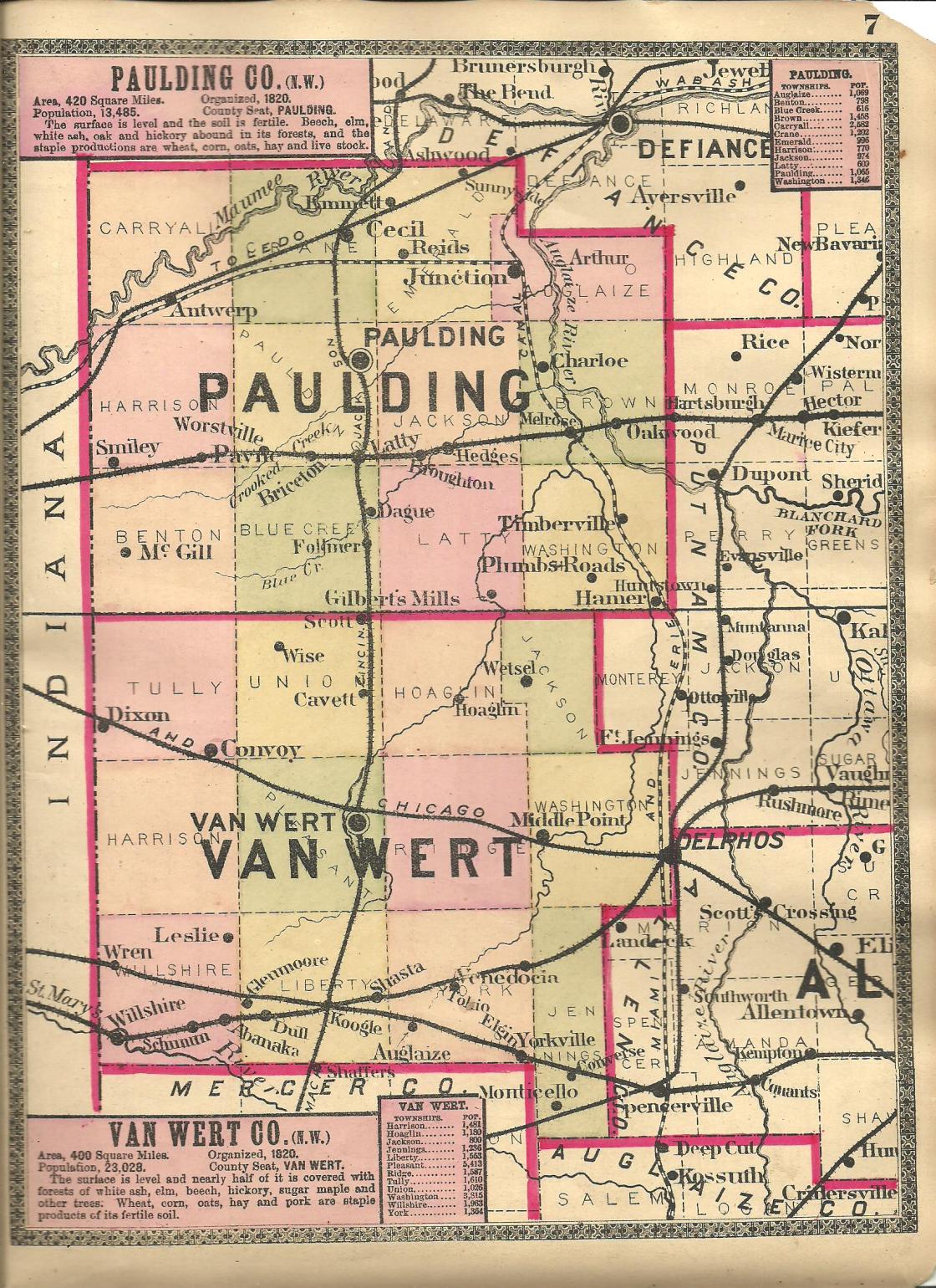
Buena Vista – York and Liberty Township
Post Office: 1866 – 1880
Location: 40.778686, -84.571367
on SR 709 at the intersection of Greenville Rd
Remnants: Wallick (Granger / Rowland) Cemetery on the east side of Greenville Rd about 1/2 of a mile north of the GPS coordinates.
Description: Buena Vista was founded by Jacob Wallick (1783 – 1874) and Elizabeth (Haverstock) Wallick (1796 – 1866), both born in Pennsylvania. They got married in Tuscarawas County in 1817, had several children, and moved to Van Wert County in 1852 where they purchased an 80-acre farm in the southeast corner of the GPS coordinates. The town was named after Buena Vista, Mexico where a famous battle took place during the Mexican – American War. It had a general store, saloon, saw mill, blacksmith shop, an ashery, a couple of local one-room schoolhouses, and a Methodist church. The post office was called Buena, with Civil War veteran Captain William R. Lawrence (born c. 1828) as the first known postmaster. He later moved out of state with his family and was buried with relatives in Mount Hope Cemetery on the north side of W Park Dr (US 24 BUS) in Huntington County, Indiana. French immigrant Philip C. Handwerck (1842 – 1922) was the last known postmaster and was buried with relatives in Woodland Union Cemetery about 9 1/2 miles north of the GPS coordinates on Woodlawn Ave in Pleasant Township. Jacob and Elizabeth were laid to rest with relatives and other residents in Wallick Cemetery. Unfortunately, Buena Vista was passed up by the railroads in the county and faded into obscurity prior to 1900.
East Wren – Willshire Township
Location: 40.800822, -84.746742
on Wren – Landeck Rd (Co Hwy 6) at the intersection of Harrison Willshire Rd (Co Hwy 35)
Remnants: East Wren (Saint Marys) Cemetery on Cemetery Rd south off of Wren – Landeck Rd
Description: East Wren was 1 1/2 miles east of Wren and was founded in 1837 by a group of freed slaves from Virginia. They were emancipated by John Randolph (1773 – 1833), who was a cousin of 3rd U.S. President Thomas Jefferson, and deeded 40 – 60 acres of land to those who remained in Willshire Township. Most of the other members of the group of over 300 former slaves went to Hanktown in Miami County and Rumley in Shelby County. The exact numbers are unknown, but residents from each of the towns who were members of the emancipated group served in the Civil War, including at least 11 from East Wren. A Methodist Episcopal congregation formed in 1843 and had a church called St. Mary’s in the northwest corner of the intersection. There was also a Second Zion Baptist church which formed in 1883. The Erie Railroad passed through the south side of town along Twentyseven Mile Creek and East Wren Cemetery. The cemetery fell into disrepair in the mid to late 1900s, but has since been cleaned up and is currently well-maintained. A geocache, named “Down The Lane #26”, is also reportedly hidden there.
Frances – Harrison and Pleasant Township
Post Office: 1893 – 1903
Location: 40.822364, -84.707628
on German Church Rd (Co Hwy 86) at the intersection of Convoy – Heller Rd (Co Hwy 55)
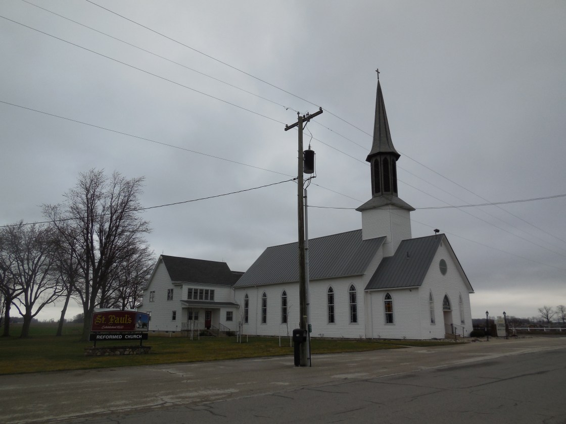
Remnants: Saint Paul’s Reformed Church and Evangelical Protestant Cemetery on the north side of German Chruch Rd just east of the GPS coordinates, Saint Thomas Lutheran Church on the north side of German Church Rd just east of Saint Paul’s, old houses and farm buildings in the area
Description: This farming town was mostly settled by German immigrants in the 1830s with the Saint Thomas church congregation forming shortly after in 1839. Construction of their present brick church began in 1898. It was completed at a cost of $6,232 with the steeple stretching 102 feet toward the sky. Saint Paul’s congregation was established in 1841. Its current wood frame structure was built in 1893 at a cost of $5,000 with the steeple reaching 115 feet. They impressively stand in close proximity, seemingly competing for their higher power’s attention. A tile works owned by the Germann family was on the north side of German Church Rd about 1/2 of a mile west of the GPS coordinates in the late 1800s. There was also a steam-powered saw mill a mile east of the GPS coordinates on the south side of German Church Rd. Phillip J. Germann (1843 – 1902) was the first postmaster. He married Sophia (Heffner) Germann (1851 – 1935) and had a few children. One of their sons, Conrad L. Germann (1876 – 1964), took on the postmaster position after his father passed away. They were all laid to rest in the cemetery and have over 100 relatives and descendants interred there.
Leslie – Willshire Township
Post Office: 1858 – 1891
Location: 40.800642, -84.698274
on Wren – Landeck Rd (Co Hwy 6) at the intersection of Co Hwy 57
Description: The original propietors were George Leslie (1811 – 1897) from Pennsylvania and Ruth (McQueen) Leslie (1814 – 1896) who owned a general store in the southeast corner of the intersection with George being the town’s first postmaster. They later moved to Paulding County and were buried with relatives in Saint Paul Cemetery on Town Hwy 114 at the intersection of Rd 87 in Paulding Township. H. C. Chilcoat was the second postmaster. He was succeeded by W. H. Bechtol (1837 – 1924) who held the office until it was discontinued. The town also had a school (Willshire Township No. 1) in the northeast corner of the intersection of Wren – Landeck Rd and Convoy – Heller Rd (Co Hwy 55).
Liggett – Union Township
Post Office: 1888 – 1903
Location: unknown
Description: Gurden D. Liggett (1854 – 1946) and Clarettie (Lewis) Leggitt (1857 – 1900) were born in Hocking County, got married in 1879, and had 4 children. Gurden was a farmer, school teacher, and opened a general store in Union Township where he was the town’s first postmaster. The family moved to South Dakota where their 2 sons lived out their lives and then went down to Florida where one of their daughters stayed. Gurden and Clarettie were buried with their other daughter who died in infancy and a couple of other relatives in Woodland Union Cemetery on Woodlawn Ave in Pleasant Township. Civil War veteran Josiah L. Mefferd (1846 – 1899) purchased the general store when the Liggetts moved away. He died of heart disease and was laid to rest with relatives in IOOF (Odd Fellows) Cemetery on Lincoln Hwy at the intersection of Township Hwy 176 in Tully Township. William Smith was the last postmaster. The town was listed on the Ohio Map in the 1901 George Cram atlas, but we have been unable to pinpoint its exact location.
MacAdam – York Township
Location: 40.771238, -84.551793
on Mendon Rd (Co Hwy 103) at the intersection of Jonestown Western Rd (Township Hwy 52) along Mown Prairie Creek
Remnants: none known
Description: none found
Nowlan
Location: unknown
Description: none found
Shasta (Shasta Station) – York and Liberty Township
Post Office: 1880 – 1904
Location: 40.771431, -84.571355
on Greenville Rd between SR 709 and Walnut Grove Rd along Mown Prairie Creek
Remnants: none known
Description: Shasta was a farming and merchant town on the Toledo, Delphos, & Burlington Railroad (later the Toledo, St. Louis, & Western Railroad). It was platted by German immigrant John A. Smith (1824 – 1890). He named it after Shasta, California, likely visited while spending 4 years mining out there during the gold rush. John married Rebecca (Hardenbrook) Smith (1829 – 1907) in 1854 and had 5 children. He was a justice of the peace from 1858 – 1867 and served as the county infirmary director. The town had a general store, a saw mill and planing mill, and a small cluster of houses. Its postmasters were J. N. Smith, Joseph Ross, and Ephraim B. Glass. John and Rebecca were buried with relatives 4 miles south of the GPS coordinates in Tomlinson Cemetery at the intersection of Mercer Van Wert County Line Rd (Township Hwy 18) and Tomlinson Rd.