Buck Run – Allen Township
Post Office: 1829 – 1843
Location: 40.223969, -83.462755
on SR 245 at the intersection of Buck Run Rd along Buck Run
Remnants: Buck Run Cemetery on the north side of SR 245 just east of the GPS coordinates
Description: Buck Run was one of the oldest towns in the township and was named after the abundance of deer in the area which were attracted by the stream. It had a church called Buck Run Chapel on the north side of SR 245 just west of the GPS coordinates. The first school was in the southwest corner of the intersection. It was a log cabin built in 1832 – 1833 with Amos Williams serving as its first teacher. The log structure was replaced with wood frame building next to Buck Run Chapel in the late 1830s. The last school, also wood frame, was on the west side of Maple Ridge Rd south of Buck Run. Hollis S. Amy was the first postmaster and later moved to Champaign County. He was succeeded by A. W. Hoff. Many pioneers, including 7 War of 1812 Veterans, were buried in the cemetery. Its first interment was Daniel Allen (1787 – 1832) who moved to the area from Pennsylvania in 1813 and was granted the honor of having the township named after him. Daniel had 6 children with Rachel (Burwell) Allen from New York and died from a broken neck after falling off a load of oats.
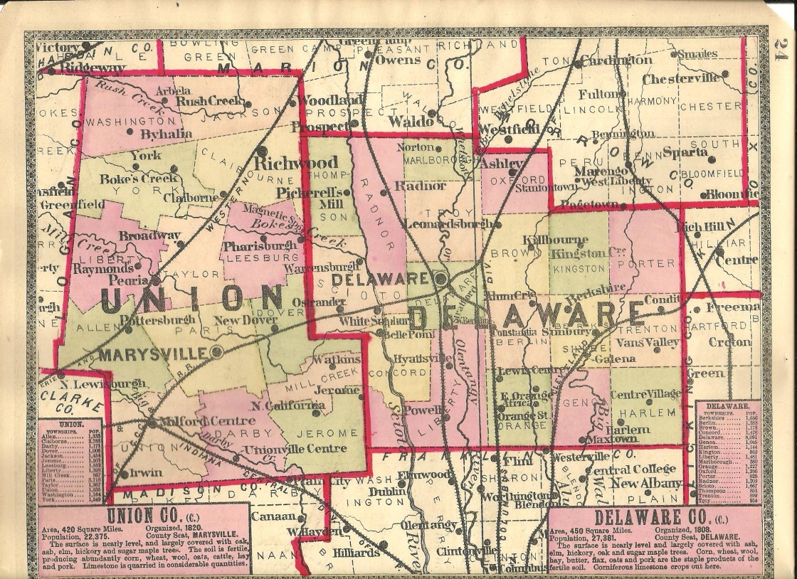
Coberlys (Coberly’s) – Allen Township
Post Office: 1832 – 1863
Location: 40.248438, -83.534485
on Inskeep – Cratty Rd (Co Hwy 163) at the intersection of N Lewisburg Rd along Big Darby Creek
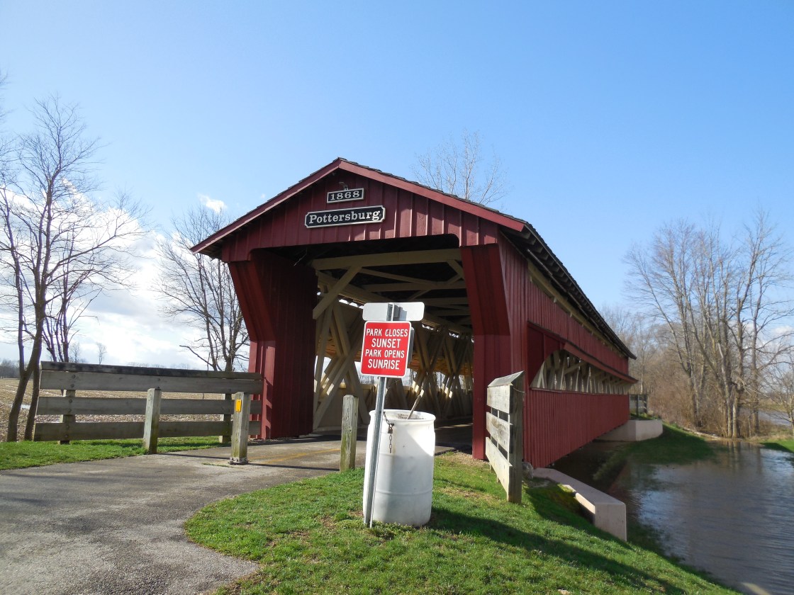
Remnants: Pottersburg Covered Bridge and historical marker on the west side of Inskeep – Cratty Rd about 1/2 of a mile southeast of the GPS coordinates
Description: The town was founded by Joseph Coberly (1792 – 1875) from Virginia and Elanor (Jones) Coberly (1796 – 1865) from West Virginia. Joseph was also the town’s first postmaster and served as township trustee. There was a school on the north side of the intersection in the mid-1800s to early 1900s. The Coberly family moved out of the state and was laid to rest in Ridgeway Cemetery on the north side of E 125th St in Osage County, Kansas. William Inskeep (1807 – 1888) was the second postmaster and was buried in Garwood Cemetery on Township Hwy 157 in Logan County. He was succeeded by Ebenezer W. Crary (1808 – 1846) who was laid to rest in Evergreen Cemetery on Main St in Painesville, Lake County. William Bales (1784 – 1875) from New Hampshire was the last postmaster. The original covered bridge, called Pottersburg or Upper Darby Bridge, crossing Big Darby Creek was constructed by Reuben Partridge (1823 – 1900) in 1868. It was moved to the North Lewisburg Trail in 2006. A new covered bridge crossing the creek on N Lewisburg Rd was built the same year.
Haynesville – Washington Township
Location: 40.481723, -83.434090
on Cunningham Arbela Rd at the intersection of Shertzer Rd along Rush Creek
Remnants: none known
Description: It was platted with 21 lots and a public square in 1838 by Jonathan Haines (1819 – 1900) as a potential rival for Arbela. Haynesville ended up being a “paper town” as there is no record of any of the lots selling. Jonathan was buried with relatives 3 1/2 miles southwest of the GPS coordinates in Byhalia Cemetery on Lingrell Rd.
Homer – Union Township
Location: 40.129296, -83.456473
on Homer Rd along Little Darby Creek at the confluence of Treacle Creek
Remnants: none known
Description: Homer was platted with 35 lots in 1834 by Elisha Reynolds (1779 – 1843) from Maryland. He arrived from New York in 1817 with his wife Mary (Witter) Reynolds (1781 – 1828). They had 7 children and Elisha was a successful merchant and county treasurer for two terms. A school (Union Township No. 7) was on the west side of Homer Rd south of the GPS coordinates. The town thrived in its early years but never had a big population boom and faded out of existence prior to 1900. Elisha remarried after Mary passed away, with Sohpia (Burnahm) Reynolds (1799 – 1875) from Connecticut, and was buried with relatives in Milford Center Cemetery 4 1/2 miles north of the GPS coordinates on Middleburg – Plain City Rd. Culbertson Covered Bridge crossing Treacle Creek 1 mile north of the GPS coordinates was partially constructed in 1922 with the superstructure of a bridge built by Reuben Partridge that formerly crossed the same creek on US 36 / SR 4. The bridge was restored by the county in 1988 and has a historical marker.
North Liberty – Darby Township
Location: unknown
Description: This first village in what would later become Union County was platted in 1797 by Lucas Sullivant (1765 – 1823) from Kentucky in the southeast portion of Darby Township along Three Mile Creek. It had 209 inlots, 116 outlots, and was expected by Lucas to turn into a large city. The only lots that sold were purchased by brothers Joshua Ewing (1765 – 1821) and James Ewing (1770 – 1850) from Pennsylvania who were county pioneers and lived there with some other family members in three cabins. A Presbyterian congregation was formed but didn’t help attract more residents. The Ewings moved to Jerome Township in 1800, abandoning North Liberty. Lucas Sullivant reportedly didn’t make any other attempts to improve North Liberty. He went on to plat Franklinton in Franklin County which later turned into Columbus, fulfilling Lucas’s dream of staring a great city. Joshua served as the first auditor of Union County and James was the first sheriff. There is a historical marker for Joshua in the southwest corner of the intersection of US 42 and SR 736 along Three Mile Creek in Plain City. Joshua and James were likely buried with relatives in Ewing (Lower Liberty Presbyterian) Cemetery which was on north side of SR 161 just west of US 42 and has since been lost to time.
Robinsons – Darby Township
Location: 40.141855, -83.306548
on Taylor Rd at the intersection of Durban Rd along Robinson Run
Remnants: none known
Description: The original proprietors were Samuel Robinson (1814 – 1886) and James Robinson (1811 – 1898) who arrived in Ohio from Connecticut in 1800. They met Lucas Sullivant in Tennessee, joined his surveying party on its way back to Ohio, and purchased 600 acres of land in Darby Township. Samuel was a carpenter, James a cooper, and they farmed and planted corn together. Both later married and their brothers Thomas, John, Alexander, and George also settled in the area. A school (Darby Township No. 4) was on the north side of Taylor Rd just west of the GPS coordinates. The Robinsons grew to be one of the largest and most successful farming families in the county. Samuel and James were buried with relatives in Mitchell (Robinson) Cemetery 5 miles west of the GPS coordinates at the intersection of SR 38 and Burns Rd.
Taylor Centre – Taylor Township
Post Office: 1857 – 1864
Location: 40.344725, -83.395697
on SR 347 at the intersection with SR 31
Remnants: none known
Description: Taylor Centre was along the Atlantic & Great Western Railroad. It had a saw mill owned by Harvey Goff (1814 – 1884) and Adaline (Castle) Goff (1816 – 1900) on their 91-acre farm in the northeast lot of the intersection. They were both born in Vermont, got married in Licking County in 1840, and had 4 children with just one surviving into later adulthood. Harvey also served at township treasurer from 1864 – 1867. The town had a school (Taylor Township No. 2) on the west side of SR 31 just south of the intersection. Zelotes C. Pooler (1809 – 1881) from New York was the first postmaster. He resigned and Harvey took on the office until it was discontinued after the railroad was built. The mail was rerouted to nearby Broadway which was directly on the railroad. As with many other places around the state, railroads often changed postal routes and turned places like Taylor Centre, just a hair too far south, into ghost towns. Zelotes Pooler was buried with relatives in Raymond Cemetery about 4 miles west of town on SR 739 in Liberty Township. Harvey and Adaline were laid to rest with relatives and other resident of Taylor Centre 1 mile west of the intersection in Broadway Cemetery on the south side of SR 347.
Westford – Union Township
Post Office: 1843 – 1850
Location: unknown
Description: Moses Fullington (1801 – 1850) from Vermont was the proprietor and postmaster. He had 4 children and remarried after his first wife, Harriet (Guy) Fullington (1805 – 1833), passed away. She was also born in Vermont and married Moses in 1822. His second wife, married in 1834, was Elizabeth (English) Fullington (1807 – 1849). They were all buried in Guy Cemetery on the east side of Guy Cemetery Rd in Pike Township, Madison County. Westford may have been the name of the post office at Homer, or Irwin before the office of that same name opened, but we have as of yet been unable to pinpoint its location.
Wilkins – York Township
Post Office: 1839 – 1866
Location: 40.438266, -83.395424
on Miller Rd at the intersection of Osborne Rd
Remnants: East York Cemetery on the north side of Miller Rd 1/4 of a mile west of the intersection
Description: The town was founded by Beriah Wilkins (1792 – 1858) from New York and Amanda (Rhodes) Wilkins (1797 – 1877) from Rhode Island. They got married in 1814, had 3 children, and Beriah was the first postmaster. A Presbyterian congregation was organized at the Wilkins house in 1839. Services were held in a school on the Miller farm until a wood frame church that stood next to East York Cemetery was constructed in 1855. It was replaced by larger frame structure in 1882. Another know holder of the postmaster position was Jonathan G. Miller (born c. 1807 – 1880) from New York. He later moved out of state with his family and was buried in Saline Valley Cemetery at the intersection of B Rd and 210th Ave in Trego County, Kansas. Beriah again became the postmaster after Jonathan resigned. John Stamates (1803 – 1895) was appointed to the position after Beriah passed away. He was succeeded by James C. Miller (1805 – 1878) who held the office until it was discontinued. Everyone mentioned in this listing aside from Jonathan G. Miller was buried in East York Cemetery.

Chuckery, OH – (1820s farming town with less residents than in the past)
Classification: small town
Location: Darby Township, Union County – On SR 161 at the intersection of SR 38
There isn’t much info online about Chuckery. It’s been a settled area since the 1820s but now appears to be more of a hamlet than a town. Chuckery did have a few schools and churches over the last couple of centuries but that’s about it. We couldn’t find any record of the town ever being platted and it never had a canal, railroad, or big businesses to make a population boom.
The largest family in Chuckery’s early days were the Bigelows. They were relatives and descendants of Isaac Bigelow (1759-1822) who founded the nearby town of Plain City. One of his nephews, Elphiaz Bigelow (1802 – 1864), constructed the Bigelow House which still stands on SR 161 close to the intersection of Ax Handle Rd.
In 1873 Bigelow Covered Bridge was built crossing Darby Creek to provide a direct link north to Marysville and was named after Eliphas. The bridge has been restored and is highlighted by Ohio Historical Marker #12 – 80. Chuckery had a post office from 1898 – 1903, which probably marked the end of its heyday. Eliphas Bigelow was buried in Bigelow Pioneer Cemetery with many of his relatives and other early families from the area on Rosedale Rd, south off of SR 161. The surrounding land is owned by the state and is called Bigelow Cemetery State Nature Preserve.

Irwin, OH (Irwin Station) – (1808 – present farming, railroad, and post office town with less residents than in the past)
Classification: small town
Location: Union Township, Union County – On SR 161 at the intersection of SR 4
Irwin was founded by John Irwin (1762 – 1830) from Pennsylvania and Anna (Steel) Irwin (1764 – 1854) from Virginia. They got married in 1791 and moved to Ohio in 1806. The town started to go by the name of Irwin in 1808. James Miller (1797 – 1891) was a carpenter and cabinet maker. He built the first house in town and spent over 85 years in Irwin but later moved to Champaign County. The town’s name temporarily changed to Irwin Station when it had a train station on the Big Four Railroad (Cleveland, Columbus, Cincinnati & Indianapolis Railroad). Farming was Irwin’s biggest industry for a long time and the town shipped hay, straw, and lumber to other places around the state and country.
During the late 1800s, Irwin had a sawmill, blacksmith, church, general store, a concrete block company, and a large number of shops and stores for a town of its size. In 1903 a massive two story brick school was built in the small town. It still stands today and is an extremely interesting sight to behold at the intersection of SR 4 and SR 161. There are also several other old buildings and residences in the area. Irwin’s post office was established in 1858 and continues to operate, but rumors are going around that it will be discontinued soon. A church is the only other public building left in town. All of the old businesses are gone and Irwin was never incorporated.
John Irwin served as justice of the peace in Union Township from 1821 – 1832, was a Presbyterian minister, and taught music. He unfortunately died from falling off his horse in 1830 and was probably buried on his farm. Anna and some of their descendants were buried in Milford Center Cemetery on Middleburg – Plain City Rd about 5 1/2 miles north of Irwin. The town’s population was around 125 in 1885 but is probably smaller than that today.