
Beavertown (Tuscarora) – Lawrence Township
Location: 40.658026, -81.442719
on I-77 along the Tuscarawas River across from the mouth of Sandy Creek
Remnants: none known
Description: Beavertown was a Delaware (Lenape) Native American town founded in the mid-1700s. It had approximately 3,000 acres of cleared land and a couple hundred residents at its peak.
Berwyn – Washington Township
Post Office: 1887 – 1902
Location: 40.242685, -81.489218
on Dunlap Creek Rd (Co Hwy 7) between SR 258 and Peoli Rd SW (Township Hwy 357) along Dunlap Creek
Remnants: Wesley Chapel and Cemetery on the east side of Chapel Rd SW 2 miles south of the GPS coordinates, old houses and farm buildings in the area
Description: It was a small farming and postal town with Joseph L. Taylor (1829 – 1914) as the postmaster. He was buried with relatives and other residents of Berwyn in Wesley Chapel Cemetery. Although the post office had already been discontinued, it was listed on the Washington Township map in the 1908 county atlas. Back then, there was a road that headed south from the town directly to Chapel Rd SW, making the journey to church much less than 2 miles.
Bevelard – Clay Township
Location: unknown
Description: Frederick Sharpee attempted to start a town on a farm adjoining Ohio & Erie Canal Lock 17 sometime around 1829 when the lock construction was completed, but his plans failed and the town of Lock Seventeen later formed near the same spot.
Blicktown – Dover Township
Location: 40.493033, -81.481042
on Stonecreek Rd NW at the intersection of SR 39 along the Tuscarawas River
Remnants: Pleasant Hill Church and Cemetery on the north side of Pleasant Hill Rd NW a mile west of the GPS coordinates
Description: It was a tiny town named after the Blick family in the county and was on the Ohio & Erie Canal and the Lake Shore & Tuscarawas Valley Railroad. It had a grist mill, saw mill, blacksmith, a lime kiln, and about 5 houses in the mid to late 1800s. The town also had a school in its early days. Some residents were buried in Pleasant Hill Cemetery.
Deardorffs Mills – Franklin Township
Post Office: 1831 – 1872
Location: 40.635338, -81.559010
on the east side of US 250 near Beach City Dam
Remnants: none known
Description: The town was founded by Christain Deardorff (1781 – 1851) from York County, Pennsylvania who also founded Dover in 1807. He operated a carding mill and a saw mill at the falls of Sugar Creek close to the present dam. The falls were well-known for their beauty and became a sort of resort destination with a hotel to accommodated travelers and local visitors. Several postmaster filled the mail office over the decasdes, inlcluding George Augustine, Samul W. Wise, Fred Harbaugh, Peter Roach, Thomas Nelson, and J. C. Hullinger. Deardoffs Mills was already declining in stature by the time the Cleveland & Tuscarawas Valley Railroad arrived in the area and the town faded into oblivion before 1900. Christian Deardorff was laid to rest with relatives in Fourth Street Cemetery on E 4th St in Dover.
Dewey – Sandy Township
Location: unknown
Description: Dewey was about halfway between Zoar and Zoarville on the Wheeling & Lake Erie Railroad. The location would have been on or near Tusky Valley Rd NE (Co Hwy 106) and the current site of Tuscarawas Valley Sr High School. It was listed on the Ohio map in the 1901 George Cram atlas.
Eagle Hill – Fairfield Townsip
Location: 40.553776, -81.412423
on the east side of the Zoar Valley Trail along the Tuscarawas River
Remnants: none known
Description: Eagle Hill was a coal mining town in the late 1800 to early 1900s. A mountain biking trail now occupied the area. The Zoar Valley Trail is a 20-mile paved recreational path following the forming track bed of the Cleveland & Pittsburgh Railroad and passes through some neat historical sites.
Zoar Valley Trail Info – https://www.traillink.com/trail/zoar-valley-trail/
East Bolivar – Lawrence Township
Location: 40.650290, -81.444902
on the east side of the Tuscarawas River across from Bolivar northwest of Glenpark Rd NE
Remnants: none known
Description: It was platted with 251 lots on the north side of the Sandy & Beaver Canal in 1837 by John Short. Construction on the canal began in 1834 and was intended to connect the Ohio & Erie Canal with the Ohio River near the mouth of Little Beaver Creek in Columbiana County. Investors spent $1.5 million on the canal project which turned out to be a man-made financial disaster. It had been dug without building aqueducts and culverts to supply enough water. As a result, East Bolivar never made it past the stage of a hopeful concept and falls into the ghost town subcategory of “paper towns”.
Egypt (Little Egypt) – Fairfield and Goshen Township
Location: 40.508408, -81.372482
on Tall Timber Rd NE between Egypt Rd and Sub Station Rd NE
Remnants: none known
Description: Egypt was on the Cleveland & Pittsburgh Railroad and had coal mines owned by the James Mullins Coal Company of Cleveland in the early 1900s.
Elm – Rush Township
Post Office: 1892 – 1904
Location: 40.311990, -81.409944
on Watson Creek Rd SE at the intersection of Edwards Ridge Rd SE along Watson Creek
Remnants: Kennedy Cemetery about 1 1/3 miles northeast of the GPS coordinates on the west side of Kennedy Hill Rd SE
Description: The town had a school (Watson Creek School No. 6) on the east side of Hines Ridge Rd just south of the creek and a Methodist church at Kennedy Cemetery. The first church structure was completed in the early 1830s. It was replaced with a new building, which has since been lost to time, in 1882 at a cost of $1,800. Curtis Linard (born c. 1873) was the first known postmaster. He was succeeded by Forrest Johnson. Although the postmasters’ graves couldn’t be located, many of their family members were buried with other residents in Kennedy Cemetery.
Greensburg (Town Quarter) – Bucks Township
Location: 40.394402, -81.691513
on Gunther – Miller Rd at the 4-way intersection of Ridge Rd SW and Renner Rd (Co Hwy 41)
Remnants: none known
Description: It was platted in 1817 in the northwest quarter of section 16 by David Seltenright (1786 – 1855) from Easton, Pennsylvania and Henry Sliffe (1783 – 1828) from Westmoreland County, Pennsylvania. A barrel of whiskey was rolled through the woods away from the road to surprise those who helped clear land for the site. The cross-shaped plat contained 72 lots, but none of them ever sold. Despite the failure of the plat, the area continued to be called Town Quarter for the next hundred years of so as a tribute to what might have been. A school (Town Quarter No. 6) was on the north side of Townquarter Dr, which is now defunct, on the west side of Renner Rd about 1/2 of a mile south of the intersection in the late 1800s to early 1900s. Henry Sliffe was laid to rest with relatives in Shanesville First Reformed Cemetery 10 1/2 miles northeast of the GPS coordinates on the west side of Hillcrest Dr NW in Shanesville. David Seltenright later moved out of the state and was buried with relatives in Fairmount Cemetery on the east side of Michigan Rd a few miles north of Plymouth in Marshall County, Indiana.
Hannatown – Mill Township
Location: unknown
Description: The town was a couple miles north of Dennison and was founded by Robert Hanna (1813 – 1896) from Harrison County and Mary (Ensley) Hanna (1808 – 1875). They got married in 1834 and had 6 daughters. On top of farming, Robert started a saw mill business in 1848 and had much success in the local real estate industry. The mills were moved from Hannatown to Dennison in the late 1860s. Robert and Mary were laid to rest in Union Cemetery on W 7th St in Uhrichsville.
Holly – Bucks Township
Post Office: 1892 – 1901
Location: 40.380339, -81.688590
on Renner Rd (Co Hwy 41) between Ridge Rd and Coal Rd (Township Hwy 92)
Remnants: Renner’s St. Paul United Church of Christ and Cemetery on Renner Rd about 1/2 of a mile south of the GPS coordinates, old houses and farm buildings in the area
Description: Holly was a small farming and postal town. The church started out as a log building and was replaced with the present wood frame structure in 1871. The building and cemetery sit on a beautiful location along the rolling hills of Bucks Township. A school was pinpointed in the 1875 county atlas a mile north of the GPS coordinates in the southwest corner of the 4-way intersection of Renner Rd, Gunther – Miller Rd, and Ridge Rd. It was on a 200-acre farm owned by Jacob S. Gonter (1815 – 1898) and Anna (Stilgenbaur) Gonter (1811 – 1882). They were laid to rest with relatives in Fiat Cemetery about 3 3/4 miles northeast of the GPS coordinates on the northeast side of Indian Spring Rd (Township Hwy 96). The old school was replaced prior to publication of the 1908 county atlas with Town Quarter No. 6 about 3/4 of a mile north of the GPS coordinates on the north side of Townquarter Dr which is now defunct and just leads to a private residence. Town Quarter was the nickname of the nearby ghost town of Greensburg. It was platted in 1817 and never grew any. George W. Everhart (1851 – 1902) was the postmaster at Holly. He was buried with relatives in Maple Grove Cemetery on N Walnut St in Dover.
Kingsville – Sugar Creek Township
Location: 40.534195, -81.632344
on Penrod Rd NW between Barrs Mills Rd NW (Co Hwy 76) and Golf Course Rd NW (Co Hwy 75)
Remnants: none known
Description: It was platted with 51 lots on 4 streets in 1831 by John King in the southwest quarter of section 19. As with most “paper towns”, for unknown reasons, none of the lots ever sold and the idea of Kingsville was subsequently scrapped.
Lawrenceville – Lawrence Township
Location: 40.650061, -81.444283
on the east side of the Tuscarawas River across from Bolivar northwest of Glenpark Rd NE
Remnants: none known
Description: A few decades prior to the platting of East Bolivar at the same location, Lawrenceville was platted with 176 lots in 1805 along the Tuscarawas River by Abraham Mosser (born c. 1748 – 1822) from York County, Pennsylvania. Donations were accepted for public buildings such as a courthouse, jail, and several churches in anticipation of Lawrenceville becoming the county seat in the future, as the location seemed fine and was already getting some trade from canoes and small boats on the river. The town had a grocery store and a shoe shop, but there were only a few houses. Lawrenceville simply wasn’t prospering and attracting residents like those who invested in the town thought it would. The plat was eventually vacated and reverted back to farmland. Some of the early residents, including Abraham, were buried in a cemetery on nearby Lebold’s Hill. The cemetery vanished long ago.
Milligan – Rush Township
Post Office: 1861 – 1871
Location: 40.336776, -81.394618
on Crooked Creek Rd SE at the intersection of Dutch Valley Rd (Co Hwy 28) along Crooked Creek
Remnants: Sanders Community Church 1/2 of a mile west of the GPS coordinates at the intersection of Crooked Creek Rd SE and Edwards Ridge Rd SE
Description: It was founded by the Milligan family in the township. They moved from Pennsylvania to Tuscarawas County in the 1830s. The town had a school and the church on land donated by the Sanders family. James Milligan was the first postmaster. He was succeeded by Thomas Milligan (1807 – 1880). Thomas was buried with relatives 2 1/2 miles southeast of the GPS coordinates in Rush Community Cemetery on the south side of Rush Church Rd SE.
Milton – Franklin Township
Location: unknown
Description: Christain Deardorff (1781 – 1851) from York County, Pennsylvania, “the father of Dover”, and James Clark platted Milton in 1816 near what would later become Deardoffs Mills. It had 56 lots, 6 outlots, and a promising future. However, Wilmot was platted just 2 miles to the north in Stark County and left Milton in the dust with its rapid growth.
Moorville (Mooreville) – City of Dover (formerly in Goshen Township)
Location: 40.508496, -81.471596
on Rick – Secker St at the intersection of Lenora St
Remnants: none known
Description: It was surveyed with 300 lots in the 1870s halfway between Dover and New Philadelphia, but the idea of having a third superpower town in the vicinity failed miserably.
Mossers – Lawrence Township
Post Office: 1812 – 1820
Location: 40.636987, -81.439567
on SR 212 at the intersection of Kerns Dr NE
Description: The town is incorrectly listed as “Moosers” in several places online. Abraham Mosser (born c. 1748 – 1822) from York County, Pennsylvania was the proprietor and postmaster, continuing his dream of town building after the failure of Lawrenceville. His cabin was about a mile east of Bolivar near the later residence of John Lebold in the 1875 county atlas. As mentioned in the Lawrenceville listing, Abraham was buried with relatives and other county pioneers in a long-lost cemetery on Lebold’s hill.
Morristown – Union Township
Location: 40.398549, -81.314320
on Penn Rd along the railroad tracks northeast of Dennison
Remnants: none known
Description: Morristown was a small village on the Pittsburgh, Cincinnati, & St. Louis Railroad. It was last spotted in the 1875 county atlas.
New England – Fairfield Township
Location: 40.517008, -81.391779
on the east side of New England Rd NE west of Tabor Ridge Rd NE
Remnants: none known
Description: It was a coal mining town founded by the Reeves Manufacturing Company in the early 1900s. The owner, Jeremiah Reeves (1845 – 1920) from Dorset, England, was buried with relatives in Maple Grove Cemetery on N Walnut St in Dover. The Jeremiah Reeves House at 325 E. Iron Ave in Dover was constructed in 1870, remodeled in 1901, and was listed on the National Register of Historic Places in 1982.
Odbert – York and Dover Township
Post Office: 1891 – 1902
Location: 40.482029, -81.485756
on Stonecreek Rd (Co Hwy 21) at the intersection of Steel Hill Rd NW (Township Hwy 329) along Stone Creek
Remnants: none known
Description: Odbert was a small farming and postal town on the Cleveland & Marietta Railroad in the late 1800s to early 1900s. Henry B. Croxton (1872 – 1924) was the postmaster.
Ontario Mills – Goshen Township
Location: 40.462608, -81.357828
on Barnhill Rd SE (Co Hwy 68) along Pike Run between Green Ridge Rd SE (Township Hwy 306) and Roxford St (Township Hwy 304)
Remnants: none known
Description: Ontario Mills was platted with 16 lots in 1853 by Robert Hanna (1813 – 1896) from Harrison County and Mary (Ensley) Hanna (1808 – 1875), the founders of Hannatown near Dennison. It was stated in the 1884 county history book that the “village did not prosper, and now nothing remains of it”. Robert and Mary were buried in Union Cemetery on W 7th St in Uhrichsville.
Pleasant Valley – Jefferson Township
Location: 40.415040, -81.554262
on Stonecreek Rd (Co Hwy 21) at the intersection of Angel Valley Rd SW (Co Hwy 49) along Stone Creek
Remnants: none known
Description: Pleasant Valley is one of the most widely used town names in the state. Approximately half of them are ghost towns. This one was platted with 35 lots by Adam Sheretts (1817 – 1851) in 1848. The plat looked nicely drawn but didn’t attract residents or businesses. Although it isn’t a town these days, the area geographically goes by the name Angel Valley. Adam was buried with relatives in Stonecreek Cemetery about 2 miles southwest of the GPS coordinates on the northeast side of Auburn St (Cemetery Hill Rd).
Rockingham – Salem Township
Location: 40.352920, -81.615256
on Burtscher Rd between Mt Zion Cemetery Rd and Township Hwy 100
Remnants: none known
Description: Peter Everhart (1814 – 1883) platted Rockingham with 20 lots on 4 streets in 1836. It’s another “paper town” that didn’t sell any lots. Peter was buried in McCullum Family (Old March) Cemetery on private property on Ridge Rd SW (Township Rd 93) in Bucks Township.
Savana – Fairfield Township
Location: unknown
Description: The town was platted with 39 lots in 1834 by Edward Ogden, David McConnell, and Israel Lappin west of the Tuscarawas River near the Ohio & Erie Canal. It turned out to be a “paper town”.
Steam Furnace – Fairfield Township
Post Office: 1833 – 1837
Location: unknown
Description: An iron furnace built by Christmas Hazlett & Co. was built in 1830 and sold to the residents of Zoar in 1834. The furnace ran until 1846 when the wood supply was exhausted in the area and it wasn’t affordable to have wood shipped in to keep the furnace running. Francis Simpson was the postmaster.
Three Legs Town – Mill Township
Location: 40.427288, -81.369000
on the west side of Brightwood Rd (Co Hwy 62) along the Tuscarawas River north of Stillwater Creek
Remnants: none known
Description: It was Delaware (Lenape) Native American town founded in the mid-1700s and the home of Chief Three Legs who reportedly had a third leg.
White Hall
Post Office: 1840 – 1844
Location: unknown
Description: S. Douglass was the postmaster.
Wilmington – Perry Township
Location: 40.248686, -81.401979
on High Hill Rd SE between Grove Rd SW and Laurel Valley Rd SE (Township Hwy 146)
Remnants: none known
Description: The town was platted with 48 lots on 2 streets in 1815 by Ephraim Sears from Lancaster County, Pennsylvania. Ephraim served as justice of the peace and township magistrate. He later moved to Missouri. Wilmington never sold any lots and most residents in the township didn’t know the place ever existed. However, it stayed in the county records until 1860 when the plat was vacated by the land owner at the time, Charles Galbraith (1816 – 1887). Charles was buried with relatives in West Union Cemetery about 4 mile northwest of the GPS coordinates on the east side of Gilmore Rd SE (Co Hwy 10).
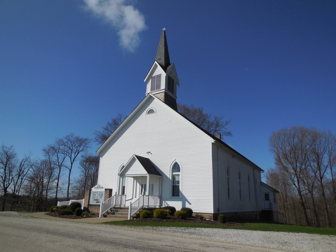
Zoar, OH (Zoar Village) – (1817 – present farming town with less residents than in the past)
Classification: historic town
Location: Lawrence Township, Tuscarawas County – On SR 212 at the intersection of Mineral City Zoar RD NE (2nd St)
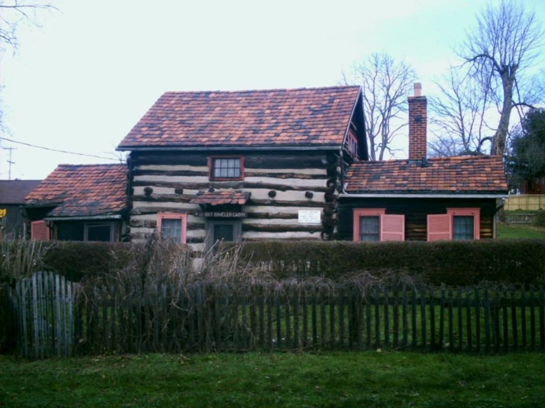
One of the coolest completely restored villages in the Ohio is on State Route 212 in Tuscarawas County. Its most recognized building is the reportedly haunted Zoar Hotel, built in 1833 on Main Street. Zoar was founded by immigrants who left Germany due to religious persecution from the Lutheran Church. They purchased 5,500 acres of land in Lawrence Township, in hopes of attaining a better quality of life. Joseph Bimeler (1778 – 1853) and Dorthea (Huber) Bimeler (1786 – 1852) founded Zoar along with 300 other settlers in 1817. It was named after the biblical city and means “sanctuary from evil”. Joseph was a pipemaker, teacher, and the leader of the group which was called The Society of Separatists of Zoar.
The Bimeler Cabin is the oldest structure in town. It was built in 1817 on 4th Street and was used as the first meeting house. Much of the land was acquired by loans that needed to be paid back quickly. The society bought the land sight unseen, and upon arrival, immediately began working on trying to figure out exactly what to do with it. They needed to know what crops could grow well there and which ones were most worth their time with planting and harvesting. Paying off the land loans as soon as possible reduced their accruing interest and lifted fears of repossession.
That goal became a source of motivation for the residents. On top of the financial stress, tensions ran high between the society members over several other aspects of life as well. Most of those tensions were ironed out in their articles of association written in 1819. The society was much like an Amish community, although there were some differences. Women worked right alongside the men in farming and did equal work. According to the articles, no one had individual rights of property. Everything was done for the good of the community and the citizens were given “the necessities of life – nothing beyond”.
A grist mill was built on the Tuscarawas River in 1821 to increase the town’s revenue and a post office opened in 1826. The state bought up some of the Society of Separatists land for the right of way of the Ohio & Erie Canal in the 1820s. Jobs for constructing 7 miles and 4 locks on the canal gave Zoar’s residents the opportunity to quickly pay off the land loans, which they accomplished by 1830 along with construction of a wool factory. The society was incorporated by the state as an organization in 1832. Over 50 of the town’s citizens died of cholera that year, but the population remained steady.
New member applications reached the post office on a near daily basis. Joining the society was tough and required making it through a probationary period. Applicants had to conform to the lifestyle, but work was easy to get. The town bought an iron furnace in 1834 that employed around 100 families. The Number One House is another impressive building in town. It was intended to be a home for the elderly. The idea was later scratched and it was given to the Bimeler Family. A second mill was built on the river in 1837. The community spread out into neighboring townships over the next few decades.
The Society of Separatists owned the train station on the Cleveland & Pittsburgh Railroad in nearby Fairfield, platted in 1854 on current-day State Route 800. It was called Zoar Station and had a general store and post office. Charles H. Ehlers (1839-1909) was the first postmaster. A group of members of the society platted Valley City with 28 lots in 1882, just a quarter mile north of Fairfield. 13 more lots were added crossing the border into Sandy Township in 1883. The name of the train station and post office in Fairfield changed to Zoarville in 1914, combining the 2 towns into one.
Back in Zoar, Joseph Bimeler’s death in 1853 caused dwindling interest in the community life and the villagers voted to disband the Society of Separatists in 1898. The town’s land was divided up between the remaining residents. A former house at the corner of E 3rd Street and Park Street was built as a house in 1863 and was owned by William Bimeler (1876 – 1928) and Lillian (Ruof) Bimeler (1876 – 1942). Lillian donated the building to the Ohio Historical Society. They converted it into The Bimeler Museum in the early 1920s. Zoar’s historic district, which encompasses pretty much the whole town, was listed on the National Register of Historic Places in 1969.
Other restored locations from the old village include the bakery, tin shop, wagon shop, blacksmith shop, dairy, and the kitchen and laundry. The garden in the middle of town is ornately planted. Historically, it has mostly been used for flowers and likely dates back to at least the 1820s. Zoar’s first school on E 3rd Street is a bed and breakfast. The Zoar Village State Memorial site is managed by the Ohio Historical Society and The Zoar Community Association. The store and visitors center is at 198 Main Street. Joseph and Dorthea Bimeler were buried in Zoar Cemetery at the end of 7th Street with most of the original society members.
Town Website – https://historiczoarvillage.com/

