Antietam – Hartford Township
Post Office: 1892 – 1904
Location: 41.332484, -80.598248
on Bushnell Campbell Rd (Co Hwy 185) at the intersection of Spencer Clark Rd (Township Hwy 189)
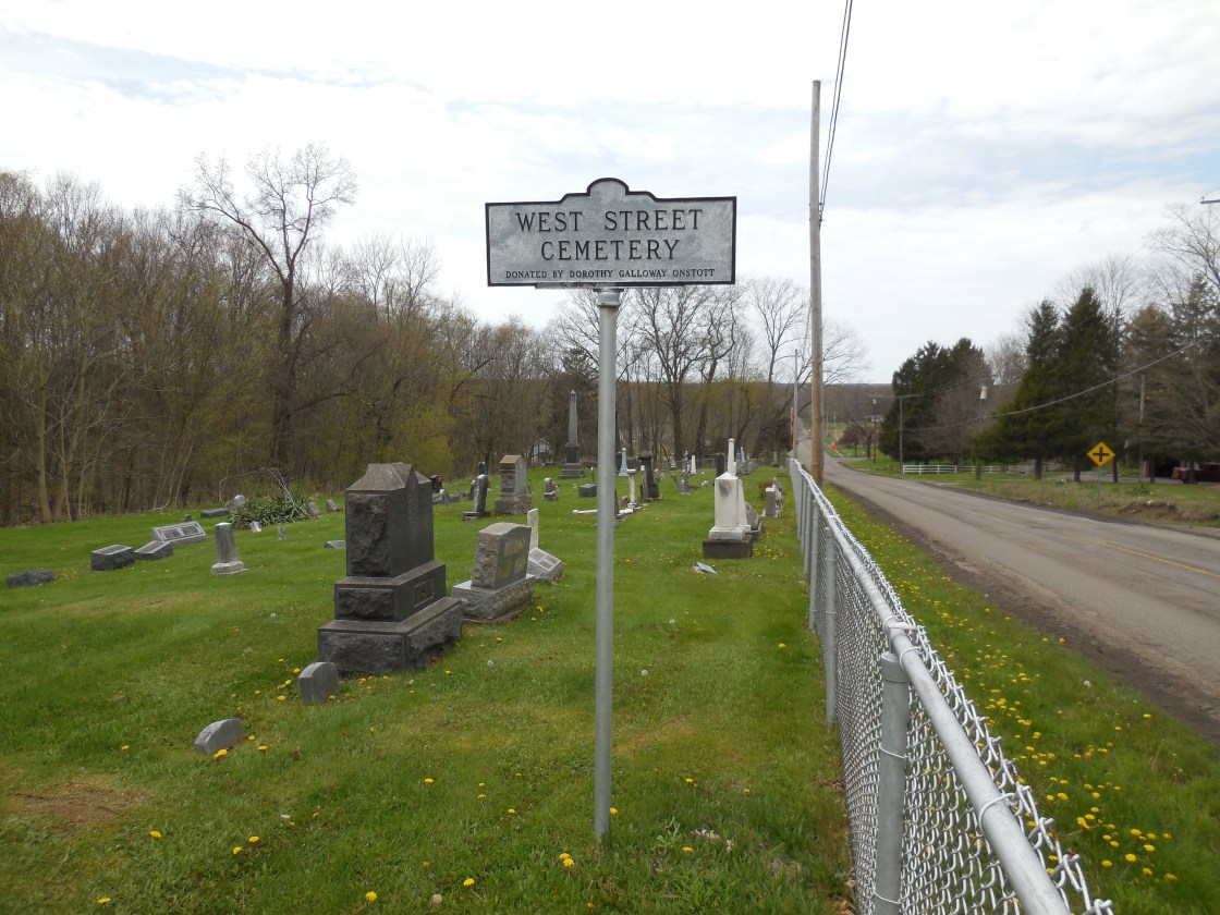
Remnants: West Street Cemetery south of the GPS coordinates on SR 305 (Wilson Sharpsville Rd) east of Bushnell Campbell Rd, old houses and farm buildings in the area
Description: Antietam was founded by the Spencer family in the area which was from Hartford County, Connecticut. Thomas C. Spencer (1842 – 1922) was the first postmaster. He married Jane (Miller) Spencer (1848 – 1928) and they owned an 81-acre farm on the west side of the GPS coordinates. Sophronia Jane (Spencer) Knight (1843 – 1910) was the last postmaster. She married Civil War veteran Frederick H. Knight (1842 – 1893) in 1866. A saw mill on the east side of Bushnell Campbell Rd south of the GPS coordinates was owned by Charles Banning (1821 – 1903) and a school (Hartford Township No. 7) south of the mill was on land owned by Dr. James Irwin (1843 – 1894) from Ireland and Anna (Bushnell) Irwin (1841 – 1901). Sophronia and Anna were likely friends, or at least knew each other. They were both born in Trumbull County and were members of their respective families who had local roads named after them. Thomas and Jane were laid to rest in Oakwood Cemetery on SR 169 (Niles Rd SE) in Warren. Everyone else mentioned in this listing was buried with relatives in West Street Cemetery.
Bentley – Brookfield Township
Location: 41.209778, -80.522015
on the railroad tracks on the north side of the Shenango River near the confluence of Little Yankee Run between Sharon – Bedford Rd and the Pennsylvania border
Remnants: none known
Description: Its proprietor was Elam Bentley (1811 – 1873) who donated land for the railroad path that runs through the area. His parents were early pioneers across the state border in Mercer County, Pennsylvania. Elam had 8 children, 6 with his first wife Rachel (Dilley) Bentley (b. 1816), and the other 2 with Elizabeth (Thomas) Bentley who he married in 1860.
Bazetta Centre – Bazetta Township
Location: 41.308311, -80.758984
near the southern end of Mosquito Creek Lake (formerly on SR 305) in Mosquito Lake State Park
Remnants: none known
Description: Bazetta Centre can be found on the 1856 county map. It had a school, Presbyterian church, and a cemetery. The 1874 and 1899 atlas also have a township hall listed at the former crossroads. The town was long gone by the time the Flood Control Act Of 1938 was implemented and the lake was completed in 1944.
Brockway (Brockway Mills) – Hartford Township
Post Office: 1891 – 1904
Location: 41.276589, -80.571810
on Thompson Sharpsville Rd (Co Hwy 186) west of SR 7 (Youngstown Conneaut Rd) along Yankee Run
Remnants: none known
Description: The town was named after Titus Brockway (1775 – 1840) from Connecticut and Minerva (Palmer) Brockway (1778 – 1826) who purchased a grist mill and saw mill next to Yankee Run and settled there in the first decade of the 1800s. Prior to their arrival at Brockway Mills, Titus was the first justice of the peace and postmaster in the township and planted the first apple tree that successfully fruited. The mills were destroyed by fire in 1822 and both of them were rebuilt. The second grist mill also burned down in 1826 and wasn’t rebuilt after that. Titus had several children with Minerva and remarried after she passed away. The property was inherited by their son Edward (1804 – 1868). Joseph Burnett (1808 – 1898) and Cassandra (Courtney) Burnett (1816 – 1892) bought the land and saw mill from Edward in 1855. They had 8 children, one son and 7 daughters. A Methodist church was constructed in 1857 and the town had a school (Hartford Township No. 2) on the Burnett farm. Peter Carlton (1821 – 1893) was the first postmaster. Byron Sutliff (1854 – 1927) was appointed to the position after Peter passed away. The Burnett and Sutliff families were related by marriage. Titus and Minerva Brockway were buried with relatives in Hartford Township Cemetery on SR 305 (Wilson Sharpsville Rd) in Hartford. Joseph and Cassandra Burnett and Peter Carlton were buried with relatives in Brookfield Cemetery 3 1/2 miles south of town at the intersection of SR 7 and SR 82 in Brookfield Township. Byron Sutliff was buried with relatives in West Street Cemetery on the south side of SR 305 west of Hartford.
Chestnut Ridge – Hubbard Township
Location: 41.193640, -80.533614
on Chestnut – Ridge Rd (Co Hwy 12) at the intersection of N Fox North Rd along Little Yankee Run of the Shenango River
Remnants: none known
Description: In its early days in the mid-1800s Chestnut Ridge had saw mill on Little Yankee Run owned by Adam T. Mizner (1814 – 1884) from Ohio and Mary Ann (Hager) Mizner (1815 – 1899) from New Jersey. They had 8 children and a 250-acre farm. Adam was a deacon of the Presbyterian church in Brookfield and a member of the board of directors of the Hubbard National Bank. The Van Ness family operated a blacksmith shop. Chestnut Ridge had a few schools during its existence. One on them on the 1899 atlas (Hubbard Township No. 3) was on the north side of Chestnut – Ridge Rd across from N Fox North Rd. The town was along 2 railroad lines in the late 1800s, the Lake Shore & Michigan Southern Railway and the New York, Pennsylvania, & Ohio Railroad.
Coles (Kinney’s Corners) (State Line) (Cornelian) – Kinsman Township
Post Office: 1839 – 1867 and 1882 – 1902
Location: 41.493081, -80.530633
on Kinsman Pymatuning Rd at the intersection of Ward Rd N (Township Hwy 267)
Remnants: State Line Methodist Church and Cemetery on W State Rd at the intersection of Bush Rd east of the GPS Coordinates across the border in Crawford County, Pennsylvania, old houses and farm buildings in the area
Description: There’s quite a lot to sort out for this small farming and postal town. It started out with a Methodist Episcopal congregation formed in 1819. A post office called State Line on the Atlantic & Great Western Railroad just south of the GPS coordinates opened in 1839. In the 1850s the town was known as Kinney’s Corners (Kinne’s Corners), named after the family that owned most of the land. It had a wagon shop operated by the Kinne family, a school (Kinsman Township No. 2), and still had the State Line post office on the railroad. The office ran until 1867. Nathan Kinne (1805 – 1873) who moved to Ohio from Massachusetts was the postmaster for most of its existence. The railroad closed shortly after the post office was disbanded and the tracks were subsequently removed. After Nathan passed away the town was called Coles for about a decade with Harmon Cole (1826 – 1890) and Sivilla (Royal) Cole (1827 – 1914) being the proprietors. The Cornelian post office opened up at the town’s main intersection in 1882 and ran under that name until 1902. In these present times the area is still called Cornelion. Nathan Kinne was buried with relatives in Kinsman Presbyterian Cemetery on Church St in Kinsman. Harmon and Sivilla were buried with relatives in State Line Cemetery. The current State Line Methodist Church brick structure was completed in 1892.
Dewey – Kinsman Township
Post Office: 1890 – 1902
Location: 41.480938, -80.603010
on Williamsfield Kinsman Rd at the intersection of Weber Cole Rd (Township Hwy 274)
Remnants: old houses and farm buildings in the area
Description: Dewey was on the Lake Shore & Michigan Southern Railway. Portions of the former track bed can be seen on satellite maps. It had a school (Kinsman Township No. 1) in the southeast corner of the intersection and a half-mile horse racetrack at the Kinsman Fair Grounds on the west side of Williamsfield Kinsman Rd south of the GPS coordinates at the bend where the road turns from due south to slightly southeast. There was also a train station at the racetrack to help bring in visitors. The land was owned by Sophia (Burnham) Kinsman (1825 – 1912). She married Thomas Kinsman (1804 – 1875) in 1847 and had a few children. Sophia was buried with relatives in Oakwood Cemetery on SR 169 (Niles Rd SE) in the City of Warren. Thomas was buried with relatives in Kinsman Presbyterian Cemetery on Church St in Kinsman. The postmasters were Henry Frazier, W. A. Lewis, and Irene (Morford) Webber.
Doughton – Hubbard Township
Location: 41.165890, -80.592017
on the east side of Bell Wick Rd at the railroad junction between I-80 and SR 304
Remnants: old houses and farm buildings in the area
Decription: The town was founded by Stephen Doughton (1822 – 1908). He was married 3 times and had 8 children. Doughton had 2 train stations, one on the Lake Shore & Michigan Southern Railway and another on the Erie Railroad. Stephen was a farmer, coal tycoon, owned a saw mill, and engaged in politics. In the coal industry, he opened mines with the Mahoning Coal Company on his land northwest of the GPS coordinates, constructed the coke ovens at Washingtonville, Ohio in Columbiana and Mahoning County, and was one of the founders of the Leetonia Iron Works in Columbiana County. The expansive “beehive” coke ovens in Leetonia are still an impressive sight to behold to this day and offer an interesting glimpse into Ohio’s coal industry past. Stephen was buried with relatives in Lisbon Cemetery on Elm St in Lisbon, Columbiana County.
Germantown – Hubbard Township
Location: 41.185481, -80.568356
on the west side of US 62 / SR 7 between New York Ln and Hibler Ln
Remnants: old houses and farm buildings in the area
Description: Germantown was platted on land owned by T. W. Lewis. It had a school (Hubbard Township No. 2) on the east side of SR 62 across from the GPS coordinates and 2 local churches to the north on Chestnut – Ridge Rd. The outline of the plat can still be seen on satellite maps and there are occasional remnants from the old town among the mostly newer residences in the area these days.
Kingsbury – Mecca Township
Location: unknown
Description: It was in the southern half of the township on land called the Kingsbury Tract, previously owned by James Kingsbury (1767 – 1848) from Connecticut and Eunice (Waldo) Kingsbury (1769 – 1842) from New Hampshire. They purchased land from the Connecticut Land Company and were the first settlers in the Western Reserve, which Ohio was carved out of, and were the first residents of Cleveland. After living next to the Cuyahoga River for a while, they moved over to Newburgh Township and founded the Newburgh Settlement in Cuyahoga County. James was a judge and served in the state legislature from 1805 – 1806. The Connecticut Land Company also gave the Kingsbury family a 100-acre lot for their struggles due to the harsh wilderness Ohio was in its early days and their willingness to remain as the first permanent settlers.
Longsville (Longville) – Hubbard Township
Location: 41.178760, -80.568452
on US 62 at the intersection of Commerce Dr
Remnants: none known
Description: Longsville first appeared as a small plat in the 1874 county atlas just south of Germantown and was founded by Henry Long (1821 – 1905) from Pennsylvania and Helen M. Long (1824 – 1891). As with Germantown, Longsville faded into oblivion in the late 1800s and didn’t make it onto the Ohio map in the 1901 George Cram atlas. Henry and Helen were buried with relatives in Old North Cemetery on the west side of US 62 (Hubbard Rd) south of the GPS coordinates.
Methodist Corners – Vienna Township
Location: 41.211452, -80.676641
on Smith – Stewart Rd at the intersection of Pleasant Valley Rd (Prindle Booth Rd SE)
Remnants: none known
Description: The town was founded in the early 1800s along with its Methodist congregation. There was a saw mill next to Squaw Creek south of the GPS coordinates, a wood frame church was constructed in 1850 in the southwest lot of the main intersection, and a school (Vienna Township No. 4) operated for several decades at the intersection of Smith – Stewart Rd and SR 193 (Youngstown Kingsville Rd SE). Milo Booth (1814 – 1896) from Vermont and Julia (Hall) Booth (1816 – 1895) owned much of the local land in the mid to late 1800s and had a few children. The Hickox and Clark families were also influential in the area and were prominent land owners. Many residents, including Milo and Julia Booth, were buried in Vienna Center Cemetery on SR 193 at the intersection of Warren – Sharon Rd (Co Hwy 329).
Mosier (Moser) – Liberty Township
Location: 41.141186, -80.693144
on US 422 (S State St) at the intersection of Trumbull Ave
Remnants: none known
Description: It was named after the Moser (Mosier) family in the county and was on the New York, Pennsylvania, & Ohio Railroad and the Pennsylvania & Ohio Canal. In its early days, the town had an oil mill and saw mill on the south side of Squaw Creek and a coal depot on the north side of the creek on land owned by the 25th Governor Of Ohio, David Tod (1805 – 1868) who served in the office from 1862 – 1864. The last public building constructed in Mosier was a one-room school built in 1887 at a cost of $800.
Motts Corners – Mecca Township
Location: 41.364478, -80.766707
on House Craft Rd at its eastern end at Mosquito Creek Lake
Remnants: none known
Description: The original proprietors were John Mott (1774 – 1846) and Harriett Mott (1795 – 1847). It was a small farming town with a steam-powered saw mill on the east side of Hoagland Blackstub Rd north of House Craft Rd and a school on the south side of House Craft Rd between the lake and Hoagland Blackstub Rd. The eastern half of what was once Motts Corners was submerged by the creation of Mosquito Creek Lake, including the entire portion of Durst Colebrook Rd (Co Hwy 195) which formerly stretched through the middle of the township. John and Harriett Mott were buried with relatives in South Mecca Cemetery on Crawford Rd off of SR 46 north of Cortland on the east side of the lake. Some of their descendants and later town proprietors were buried in Hillside Cemetery on Youngstown Kingsville Rd NE, also on the east side of the lake in Cortland. The Hoagland (from New Jersey) and Mott families were related by marriage.
Oil Diggings (Dixie) – Mecca Township
Post Office: 1860 – 1875
Location: 41.364477, -80.782870
on the north side of House Craft Rd between Morrell Ray Rd and Hoagland Blackstub Rd
Remnants: none known
Description: Residents of Mecca township always knew there was an abundance of oil in the vicinity and it was commonly thought of as a nuisance. Land that was known to contain the substance couldn’t fetch good prices when put up for sale and hampered many hopes of clean water wells for farm owners. When oil was starting to get looked at as a potential valuable commodity in the mid-1800s, word got out and speculators from all around the country set their sights on Mecca. Also called Dixie, Oil Diggings was platted in 1859 – 1860 and quickly turned into a boom town. Its post office was called Oil Diggins with M. M. Tuttle serving as postmaster. Hotels and grocery stores were immediately constructed to accommodate the speculators and there was a steam-powered saw mill on the west side of town on the north side of House Craft Rd which aided in construction efforts. Land values in the township skyrocketed to up to four times their previous value. Several wells were dug in the area and Oil Diggings had a chance of becoming a prosperous city in the future. Unfortunately the amount of oil that was easy to get to at the time ran out much sooner than expected. The Civil War contributed to the town’s decline and there were also the usual problems of other boom towns such as illegal alcohol sales, gambling, and unwanted rudimentary dwellings that were considered to be eyesores. Some of the buildings were cheaply sold to residents of Warren who moved them with sled runners when it snowed in winter and other buildings were simply left to rot away. Oil Diggings was long gone before the 1882 county history books were published. Improvements in machinery and oil extraction techniques in the later 1800s and early 1900s kept the industry going in various parts of the township though.
Old Burg Hill – Hartford Township
Location: 41.344110, -80.569516
on SR 7 (Youngstown Conneaut Rd) betwen Hayes Orangeville Rd and SR 605
Remnants: Burghill Cemetery on the east side of SR 7 north of the GPS coordinates
Description: Old Burg Hill was the original location of the town of Burghill. Its post office, store, and the commercial center of town were moved north to Vernon Township where its train station on the Atlantic & Great Western Railroad was constructed prior to publication of the 1874 county atlas. Old Burg Hill is listed in great detail and the pinpointing of its buildings on the 1856 county map.
Penza – Liberty and Hubbard Township
Post Office: 1884 – 1903
Remnants: none known
Location: 41.197954, -80.616802
on Warner Rd SE (Co Hwy 43) between Chestnut – Ridge Rd and Everett Rd
Remnants: none known
Description: It was a small farming town with a blacksmith shop, wagon shop, and a school (Liberty Township No. 7) on the west side of Warner Rd SE. William Tully (1857 – 1930) was the first postmaster. His family owned much of the land in the area in the mid to late 1800s. He was buried with relatives in Vienna Center Cemetery on SR 193 at the intersection of Warren – Sharon Rd (Co Hwy 329). Helen Leslie (1848 – 1929) was the last postmaster. She was buried with relatives in Seceders Corners Cemetery about 3 miles south of town on SR 304 (Liberty St SE).
Superior – Vernon Township
Post Office: 1890 – 1903
Location: 41.404088, -80.552951
on Orageville Kinsman Rd (Co Hwy 255) at the intersection of Jewell Greenville Rd
Remnants: old houses and farm buildings in the area
Description: The proprietors were Allen Jewell (1860 – 1919) from Vernon Township and Emma (Karr) Jewell (1861 – 1921) from Mercer County, Pennsylvania. The post office was on their 101-acre farm in the northeast lot at the GPS coordinates. Allen was successful in many endeavors in life, including farming, real estate, and business financing. He was the director of the Kinsman National Bank, president of the Jefferson And Warren Telephone Company, and secretary of the Kinsman Cattle Company in Custer County, Nebraska. Allen and Emma were married in 1883 and purchased the 101-acre farm in 1884. They build the house and several of the farm buildings which still occupy the property. The house was as modern as one could get at the time with hot and cold running water, a furnace for heat, and gas powered lighting. The town also had a school (Vernon Township No. 3) in the northwest corner of Allen and Emma’s farm and as cheese factory directly across Orangeville Kinsman Rd from Jewell Greenville Rd on land owned by Allen’s father and stepmother. Allen and Emma were buried with many relatives and descendants in New Kinsman Cemetery on Church St in Kinsman.
Sutherland (Duck Creek Settlement) (Duck Creek Corners) – Newton Township
Post Office: 1818 – 1865
Location: 41.144392, -80.918437
on Hallock Young Rd at the 4-way intersection of Newton Tomlinson Rd and Hallock Sook Rd along Duck Creek
Remnants: Duck Creek Cemetery on the west side of Hallock Sook Rd south of the GPS coordinates
Description: The town was founded by Alexander Sutherland (1767 – 1845) and Sarah (Schoonhoven) Sutherland (1768 – 1836). They were the first permanent settlers in Newtown Township, moving to Ohio from Westmoreland County, Pennsylvania in 1802, and purchased 205 acres along Duck Creek. Alexander was a Freemason, the first surveyor of Trumbull County, the second recorder, postmaster when the office was called Sutherland from 1827 – 1837, and held various other public positions. During the times when the post office wasn’t called Sutherland it went by Duck Creek. There was a school on the north side of Hallock Young Rd west of the GPS coordinates. Alexander and Sarah had several children and were buried with relatives in Duck Creek Cemetery. Duck Creek is still a populated place but its center has since moved a few miles north.
Walnut Hill – Brookfield Township
Location: 41.248058, -80.521514
on Walnut Hill Rd (Superior St) at the intersection of B St
Remnants: none known
Description: Walnut Hill first appeared with a plat in the 1874 county atlas. Some of the lots were purchased and there was a school (Brookfield Township No. 8) on the east side of Sharon Hogue Rd north of Walnut Hill Rd which can be seen along with the still existing plat in the 1899 county atlas. Although the area was never abandoned, the town itself disappeared in the early 1900s.
Wassie – Bristol and Champion Township
Post Office: 1891 – 1903
Location: 41.348250, -80.898077
on Bristol Champion Townline Rd NW at the intersection of Oak Hill Dr (Co Hwy 205)
Remnants: none known
Description: It was a small farming town with a school (Bristol Township No. 6) on the west side of Corey Hunt Rd. The school was on land donated by the Fansler family. Silas S. Corey (1842 – 1928) was the first postmaster and was buried with relatives in Hillside Cemetery at the intersection of Youngstown Kingville Rd NE and McCleary Jacoby Rd in Cortland. He was succeeded by William Harklerode (1845 – 1934) who was laid to rest in East (East Farmington) Cemetery 3 1/2 miles northeast of the GPS coordinates at the intersection of SR 88 (Greenville Rd NW) and Hoffman Norton Rd NW (Co Hwy 213).
York (Barclay) – Gustavas Township
Post Office: 1887 – 1900
Location: 41.450550, -80.635020
on Gardner Barclay Rd at the railroad crossing between Stoddard Hayes Rd and Mayburn Barclay Rd along Clear Creek
Remnants: East Gustavas Cemetery on the south side of Garnder Barclay Rd west of the GPS coordinates
Description: The original proprietors were Amos York (1847 – 1911) from Indiana and Lois (Schrycengart) York (1850 – 1932) from Bristol Township. Its post office was called Barclay and is still a populated place. There was a cheese factory on the south side of SR 87 (Kinsman Rd NE) across from the intersection of Barclay North Rd (Co Hwy 287) and a school on the north side of Gardner Barclay Rd near the intersection of Mayburn Barclay Rd close to where the post office was. George C. Logan (1836 – 1903) was the first postmaster. He was succeeded by Richard M. Evans (1850 – 1924) who was laid to rest in Kinsman Cemetery 3 miles east of the GPS coordinates on Church St in Kinsman. Amos and Lois had a few children and 2 of their sons, Joe and Job, donated land for the track bed of the New York Central Railroad in the early 1900s. Amos and Lois were also buried with relatives in Kinsman Cemetery. Many other residents were buried in East Gustavas Cemetery.
Ohltown, OH – (early 1800s – present farming and mill town)
Classification: small town
Location: Weathersfield Township, Trumbull County and Austintown Township, Mahoning County – On Ohltown Rd north of I-80
The town was founded by Michael Ohl (1784 – 1857) and Eva (Moyers) Ohl (1786 – 1860). They were married in 1838 and had 8 children. Michael constructed a saw and grist mill in 1844 on the banks of the Meander Creek, operated a hotel, and was the first postmaster of the office that ran from 1841 – 1902. The first church in Ohltown was built in 1838, a school in 1857, and a bank in 1868. During the 1880s the town also had about 30 houses, a blacksmith shop, two stores, a newer grist mill, and a train station on the Niles & New Lisbon Railroad. Many of the local residents worked in coal mines or at the Meander Iron Furnace.
There are several Ohl descendants buried in Ohl Town Cemetery next to the United Methodist Church at the intersection of Ohltown Rd and Austintown Warren Rd. It’s right across the Mahoning County border in Trumbull County. Michael and Eva Ohl were buried in Old North Cemetery on SR 46 (N Broad St) in Canfield. Today Ohltown is basically a suburb squeezed between Youngstown, Austintown, and the Meander Creek Reservoir.