Boothsport (Old Portage) – City of Cuyahoga Falls (formerly in Northampton Township)
Location: 41.140952, -81.564470
on Riverview Rd (County Rd 9) at the intersection of Smith Rd along the Cuyahoga River
Remnants: none known
Description: The town was originally called Old Portage and began with a general store and tavern around 1815 owned by Samuel King. Later in 1827, the Ohio & Erie Canal arrived in the area and Judge Birdsey Booth (1797 – 1862) from Connecticut built a freight warehouse for receiving and shipping products. The town rapidly grew and became known as Boothsport. It couldn’t keep up with Akron though and declined as quickly as it rose in just a few short years. Birdsey moved with his wife Eunice (Hull) Booth (1798 – 1892) and 2 children to Cuyahoga Falls in 1832. Birdsey and Eunice moved again to Grand Rapids, Michigan in 1861 and were buried there with relatives in Fulton Street Cemetery.
Bosworth (Bossworth) – City of Macedonia (formerly in Twinsburg Township)
Location: 41.280875, -81.483366
on E Twinsburg Rd at the railroad crossing between Walters Rd and Valley View Rd
Remnants: none known
Description: Bosworth was on the Cleveland & Pittsburgh Railroad and had a school on the west side of Valley View Rd north of E Twinsburg Rd. Luman Oviatt (1819 – 1902) and Lucinda (Craig) Oviatt (1823 – 1892) were married in 1842, had a few children, and owned the largest farm in the area. The train tracks were leased to the Pennsylvania Railroad and have since been acquired by Norfolk Southern. Luman and Lucinda were buried with relatives in Oviatt Cemetery behind a house on private property on the west side of Valley View Rd just south of E Twinsburg Rd.
Brownsville
Location: unknown
Description: none found
Cartersville – Village of Clinton (formerly in Franklin Township)
Location: 40.914709, -81.634379
on the Congressman Ralph Regula Towpath Trail between S Cleveland Massilon Rd and the Tuscarawas River
Remnants: none known
Description: A wealthy Quaker named Richard Carter platted Cartersville in 1806 at the confluence of the Tuscarawas River and Chippewa Creek. The plat frequently flooded and none of the lots sold.
Chaffee – Sagamore Hills Township (formerly in Northfield Township)
Location: 41.316580, -81.577869
on SR 82 at the intersection of Chaffee Rd
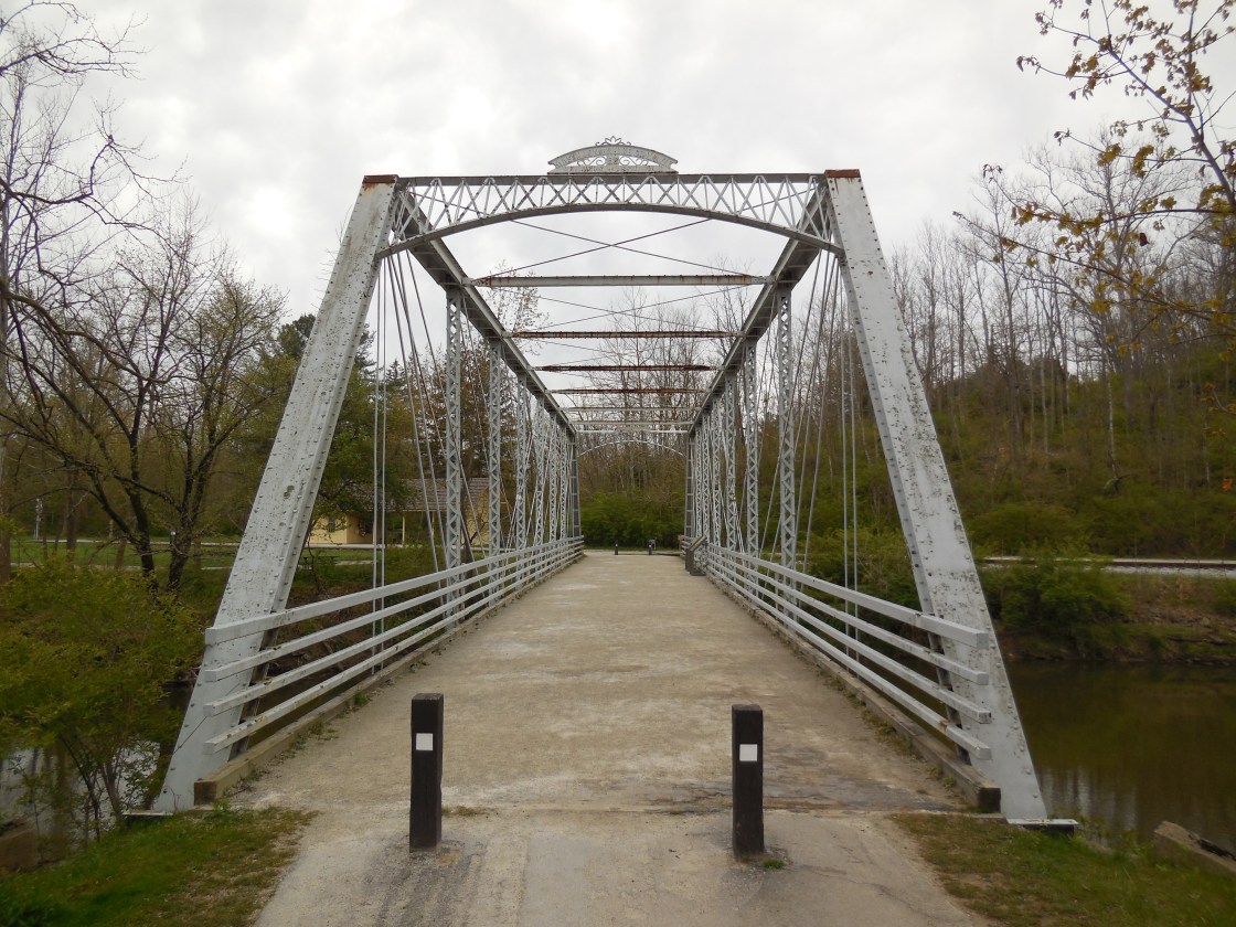
Remnants: Station Road Bridge crossing the Cuyahoga River about 1/2 of a mile northwest of the GPS coordinates, Canal Lock #17 with a historical marker about 1/3 of a mile north of the bridge along the Ohio & Erie Canal Towpath Trail
Description: Chaffee was along the Ohio & Erie Canal and had a steam-powered saw mill between the canal and the Cuyahoga River. It was founded in the mid-1800s by Comfort J. Chaffee (1817 – 1908) and Asenath (Ferry) Chaffee (1819 – 1904), both born in Massachusetts. They got married in 1845, had 2 children, and accumulated a 375-acre farm. The farm produced milk with around 70 cows and the family later switched to livestock raising. Timber from the Chaffee farm was also cut in the saw mill and some it was used to construct boats. A school was east of the GPS coordinates on the south side of SR 82 just east of Carter Rd. The canal lock was pinpointed in the 1874 county atlas. Station Road Bridge was completed in 1882 by the Massillon Bridge Company. Its currently open to pedestrian traffic and leads to the Brecksville station of the Cuyahoga Valley Scenic Railroad. The bridge was replaced in 1931 by the present concrete structure just to its north on SR 82. After an extensive an exhaustive search, it’s unknown where Comfort and Asenath were laid to rest.
Coles – City of Akron (formerly in Portage Township)
Location: unknown
Description: Coles was on the Pittsburgh, Akron, & Western Railroad on the northwest side of Akron. It would have been on the east side of present-day Portage Country Club.
Davis
Location: unknown
Description: none found
Irene – City of Norton (formerly in Norton Township)
Post Office: 1889 – 1890
Location: unknown
Description: none found
Iron Bridge (McArthurs Corners) – City of Cuyahoga Falls (formerly in Northampton Township)
Location: 41.152315, -81.508671
on State Rd at the intersection of Graham Rd along Mud Brook
Remnants: Harrington Cemetery north of the GPS coordinates on the east side of State Rd, former mill pond on the east side of State Rd just north of the GPS coordinates
Description: Named after its former bridge which crossed Mud Brook, this tiny town had a busy existence. It all began with a grist mill next to Mud Brook, built in 1805 by Judge Aaron Norton (1776 – 1825) from Connecticut. A distillery followed the grist mill, the first destroyed by fire, and a second one was built by Wesley Hamilton and Aaron Norton. Meanwhile, the French and Hays families constructed a saw mill. The mills were purchased by War of 1812 veteran Colonel Rial McArthur (1783 – 1871) and the town was subsequently called McArthurs Corners. In 1839 William Prior (1783 – 1872) from Massachusetts bought the mill site and built a new grist mill. Harry Pardee purchased the saw mill and constructed a wool factory in 1842. After Colonel McArthur sold his interests in the town, the location was called Iron Bridge. The residents formed a joint-stock company and in 1871 construction of a milk and cheese factory was completed at a cost of $2000. In 1880, its 500 cows produced 20,000 pounds of butter and 168,000 pounds of cheese. Milk was sold by the gallon at around 10 cents each. There was also a school on the west side of State Rd north of the GPS coordinates. The town faded away in the late 1800s and didn’t make it onto maps in the 1900s. Many residents and pioneers, including William Prior and Rial McArthur, were buried in Harrington Cemetery. It was established on the 130-acre farm of War of 1812 veteran Job Harrington (1792 – 1869) who made his journey to Summit County from Bennington County, Vermont on foot. Aaron Norton was buried with relatives in Middlebury Cemetery on Newton St in Akron.
Niles (Vallens) (Buckeye) (Botzum) – City of Cuyahoga Falls (formerly in Northampton Township
Post Office: 1852 – 1857, 1866 – 1893, and 1893 – 1900
Location: 41.162116, -81.575176
on Riverview Rd (County Rd 9) at the intersection of W Bath Rd (County Rd 27) at the confluence of Yellow Creek and the Cuyahoga River
Remnants: Conrad Botzum Homestead 1 mile north of the GPS coordinates on the west side of Riverside Rd
Description: Peter Voris (1799 – 1880) from Pennsylvania and Julia (Coe) Voris (1807 – 1858) from Connecticut met and married in Stark County in 1826. They moved to Summit County in 1834 and platted Niles on 100 acres along the Ohio & Erie Canal at the mouth of Yellow Creek in 1836. Peter later went on to serve Summit County in the state senate and was appointed to a judicial position. Only a few of the residential lots sold in Niles, but it did attract some businesses due to the prime location. The town had 2 stores, a warehouse, and a saw mill on the west side of the Cuyahoga River. A school and a tavern built by Nathaniel Hardy (1796 – 1866) from Massachusetts and Rebecca (Reed) Hardy (1805 – 1865) were on the east side of the river. The Vallen family bought several lots in the area and Jacob Vallen (1824 – 1884) was the first postmaster. After that first office closed, its name reverted back to Niles for a short while. However, the town’s second post office was called Buckeye from 1866 – 1893. A hotel with a band room and ball room owned by the Thomas family opened up on the east side of the river with a village band called The Buckeye Band boarding there. John A. Botzum (b. 1834) from Germany donated land for a train station called Botzum on the newly laid Valley Railroad, opened a general store, and changed the post office name to match the station. He was also the town’s last postmaster. Botzum is still a populated place and pops up on Google Maps, but the village itself is long gone and didn’t make into the 1910 county atlas. One of John A. Botzum’s brothers, Conrad Botzum (1836 – 1914) also settled in the area in the mid-1800s. He married Louisa (Young) Botzum (1843 – 1914). They had a large farm and 9 children. Their former residence is available for weddings, birthday parties, and events. Conrad and Louisa were buried with relatives in Saint Bernards Cemetery on Glendale Ave in Akron. The Botzum Trailhead for the recreational trail of the Ohio & Erie Canal Towpath is south of the GPS coordinates in a park on the west side of Riverview Rd. There is also a replica Botzum train station for the Cuyahoga Valley Scenic Railroad. Nathaniel and Rebecca Hardy were buried with relatives and other early pioneers in Northampton Cemetery 2 miles east of town on the north side of W Bath Rd. Jacob Vallen was buried with relatives in Mount Peace Cemetery about 6 miles south of town on the east side of Aqueduct St in Akron. Peter and Julia Voris moved out of the state in 1857 and were buried with relatives in Dodge Grove Cemetery on South Dr in Mattoon, Illinois.
Botzum Farmstead Info – https://www.botzum.org/
Sherman (Dennison Station) – City of Norton (formerly in Norton Township)
Post Office: 1869 – 1902
Location: 41.012685, -81.667561
on S Hometown Rd at the intersection of Sherman Rd
Remnants: none known
Description: The town was originally called Dennison Station and was on the Atlantic & Great Western Railroad. It can be spotted in the 1874 county atlas. A mine operated by the Norton Coal Company brought in residents who lived in a small plat of company built houses in the lot on the northeast side of the GPS coordinates. Schools and churches used by the residents are attributed to Hametown just to the south. The railway was reorganized as the New York, Pennsylvania, & Ohio Railroad in 1880 and the town name changed before getting listed as Sherman in the 1891 county atlas. It also appears the coal had run out by then. Sherman maintained its existence in the early 1900s, even after losing its post office, but its days were numbered. It was last seen in the 1910 county atlas, along with the Erie Railroad which previously leased the train tracks a couple of times.
Spicertown – City of Akron (formerly in Portage Township)
Location: 41.072300, -81.506279
on Spicer St at the intersection of Nash St
Remnants: none known
Description: Miner Spicer (1776 – 1855) and Cynthia (Allyn) Spicer (1778 – 1829) moved to Ohio from Connecticut and were the first settlers in Portage Township. They purchased a 260-acre farm and founded Spicertown in 1811. After Cynthia passed away, Miner married one of her widowed sisters, Hannah (Allyn) Spicer (1792 – 1856). The town of Cascade, later platted as Akron on the northwest side of Spicertown, grew much faster. It had the added benefit of better access to the Little Cuyahoga River, surpassed Spicertown in industry, and attracted the Ohio & Erie Canal. Spicertown was annexed into Akron prior to the completion of the 1874 county atlas, along with Middlebury founded in 1807 just to its east. Summit City founded in 1843 on the north side of Akron was annexed prior to the completion of the 1910 county atlas. As with all of Ohio’s current large cities, natural selection, survival of the fittest, and gobbling up smaller towns along the way is how they reached greatness and longevity. Miner, Cynthia, and Hannah Spicer were buried with relatives in Glendale Cemetery a little over 2 miles northwest of the GPS coordinates on Glendale Ave in Akron. Some of the buildings and businesses near the GPS coordinates still bear the Spicer family name.
Tod Branch – City of Akron (formerly in Springfield Township)
Location: unknown
Description: Tod Branch was on the Valley Railroad and had coal mines owned by the Summit Bank Coal Company.
Waterloo – City of Akron (formerly in Coventry Township)
Location: 41.030622, -81.546567
on W Waterloo Rd at the intersection of SR 93 (Manchester Rd)
Remnants: none known
Description: Waterloo was along the Ohio & Erie Canal and had a grocery store that was dubbed as “famous” for its strategic location and selection of goods. In the later 1800s, a town hall was built in the northeast corner of the intersection and was used for elections and a general meeting hall.

Boston Mills, OH (Helltown) – (1806 – 1974 mill and railroad town acquired by the Cuyahoga Valley National Park)
Classification: ghost town
Location: Boston Township, Summit County – On Boston Mills Rd at the intersection of Main St
GPS Coordinates: 41.263241, -81.559419
Boston Mills was settled by surveyors from Connecticut in 1806 who built a cabin on the grounds of what is now the Boston Cemetery. It was originally in Portage County and the township was named Boston after Boston, Massachusetts. The village also got the same name as it was the first in the township. There were several mills in the area including saw mills and paper mills operated by the Cleveland – Akron Bag Company. A post office was organized in 1825 but was discontinued later that year.
The town grew with the introduction of the Ohio & Erie Canal in 1827. A new post office opened in 1832. On top of the mills, it also had a warehouse, two stores, a hotel, school, blacksmith shop, broom factory, and several businesses that dealt in building boats for the canal. After the canal was abandoned, Boston Mills got a train station on the Valley Railroad which kept the area thriving for many more decades. The post office remained in nearly continuous operation until 1957.
There are a few stories of haunted places around the town. Boston Cemetery at the end of Main St is said to be haunted, as well as the “Crybaby Bride” on Boston Mills Rd that leads into town, and several other old buildings around the area. There are also stories about the Krejci Dump on Hines Hill Rd containing toxic substances and a government cover-up to stamp down the rumor. It was intensified in 1974 when Boston Mills was designated a national recreation area.
Some of the remaining residents were forced out by eminent domain and their houses were demolished as the town became part of the Cuyahoga Valley National Park. An urban legend of a giant snake from the reportedly toxic dump roaming around sometimes keeps people out of the woods, plus stories of local groups of cults and satanists who don’t want people to know what they’re doing back there. The “End Of The World” is the name given to the spot where a portion of Stanford Rd abruptly ends and is closed off from traffic.
The Boston Mills Historic District was added to the National Register of Historic Places in 1992 and has a visitors center at the former store on Boston Mills Rd. M.D. Garage next to the visitors center was built in 1946 as a gas and auto service station. It’s restored and houses historical exhibits. Boston Community Church at the corner of Boston Mills Rd and Hines Hill Rd was constructed in 1911 and originally used as a school. A replica train station at the intersection of Riverview Rd (County Rd 9) and Boston Mills Rd is used by the Cuyahoga Valley Scenic Railroad which operates rides for local tourism. There are also many old houses in the historic district.
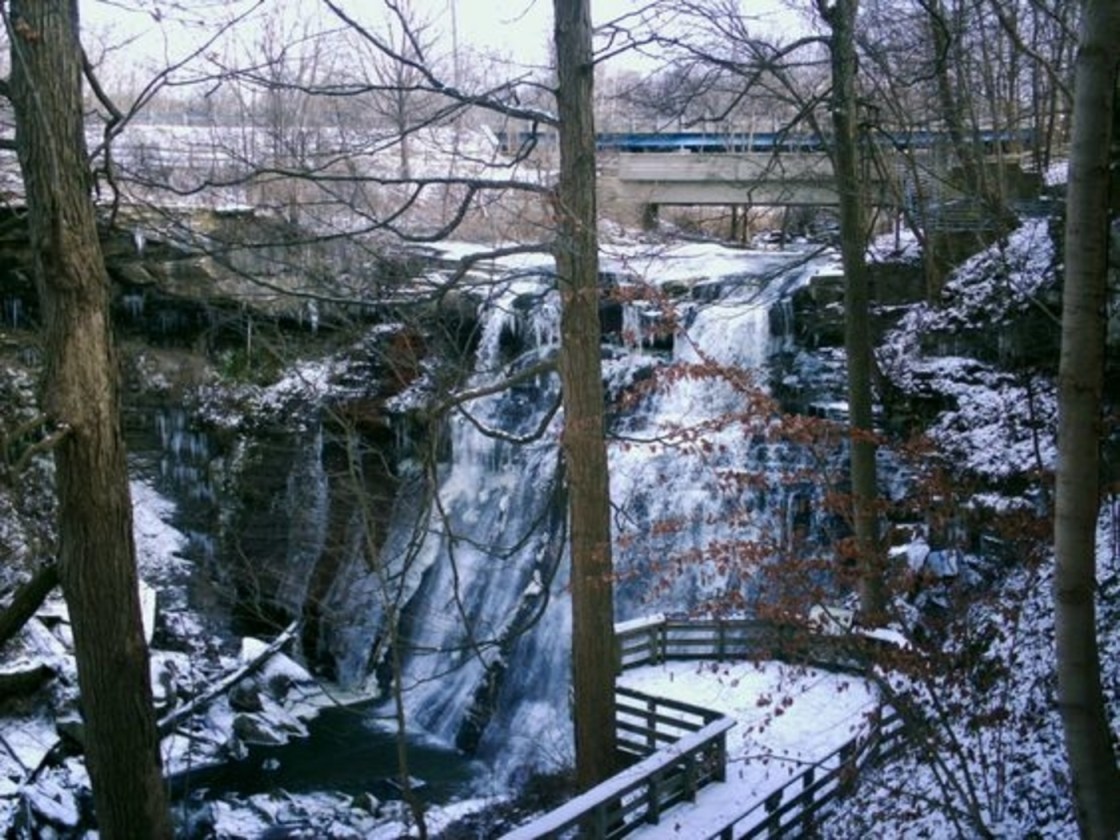
Brandywine Mills, OH (1816 – 1937 mill town abandoned due to lack of economic opportunities)
Classification: ghost town
Location: Northfield Center Township, Summit County – On Brandywine Rd north of the overpass of I-271
Brandywine Village was settled in 1814 by George Wallace (1771 – 1849) and Harriet (Menough) Wallace (1784 – 1848). They had 4 children and built their homestead next to the creek which Harriet named Brandywine. The small town grew to be the most important economic center between Cleveland and Pittsburgh and rivaled Cleveland in business and education.
In 1816 George built a sawmill on Brandywine Falls beside their cabin and also built a whiskey distillery that same year. A few years later he built a grist mill and then a wool factory in 1821. More settlers moved into the town. A Presbyterian church and a school were quickly built to accommodate them, along with a dozen or so houses. The whiskey distillery could produce 30 – 40 gallons a day. Back then, the whiskey was affectionately called “Brandywine Currency”. George wasn’t a member of the church, but he gave 10 gallons of whiskey every year to the minister.
At the age of 15 George’s son James Wallace (1803 – 1887) started managing the general store that was on the second floor of the grist mill. A few years later James and his brother George Young Wallace (1805 – 1844) were put in charge of the Wallace’s 1,200 acre farm which had over 2,000 sheep, 75 cattle, and 10 – 15 horses. The Brandywine Mills post office was the first one in Northfield Center Township and ran from 1825 – 1855 with George Sr. being its first postmaster. Later in 1825 George transferred the ownership of the mills to his sons who started up the Wallace Brothers Company with the mills, farm, and a larger new general store. Brandywine’s remaining days were numbered though because the town was passed up by the Ohio & Erie Canal and the railroads.
The mills were abandoned by the Wallace family before 1900. In 1920 Willis W. Hale (1882 – 1947) purchased what was left of the Wallace’s grist mill and built the Champion Electric Company which manufactured restaurant appliances. It was destroyed by a lightening fire in 1937. Today the location of Brandywine Village is in the Cuyahoga Valley National Park. There is a parking lot next to Brandywine Falls off of Brandywine Rd north of the overpass of I-271. The foundation of one of the mills and a few barely noticeable house foundations can be found at the site of the old village.
James Wallace’s house was built in 1848. It has been restored and turned into a bed and breakfast called The Inn at Brandywine Falls. The old cemetery at Brandywine Village was moved to Northfield – Macedonia Cemetery. It’s at the intersection of Olde 8 Rd and Valley View Rd 3 1/2 miles north of Brandywine Falls with a marker that reads, “Here lies the remains of the early settlers who originally were buried at Brandywine Falls”. The Wallace family is buried there with several of their descendants.
The Inn At Brandywine Falls Website – https://www.innatbrandywinefalls.com/
Thanks to group member Brett Taylor, manager of Ohio Hiking Trails and Historical Sites, for providing the lead on Brandywine Village!