Bancroft – Pike and Bethlehem Township
Post Office: 1894 – 1902
Location: 40.707710, -81.431345
on Sherman Church Ave SW at the intersection of Seeman St SW
Remnants: Sherman Cemetery about a mile south of the GPS coordinates at the intersection of Sherman Church Ave SW and Haut St SW
Description: The proprietors of this short lived postal town were Joseph Buchtel (1827 – 1902) and Margaret (Warner) Butchet (1836 – 1922), both born in Stark County. They were married in 1845, had a few children, and owned an 80-acre farm in the southwest lot of the GPS coordinates. Joseph was the postmaster and the office was discontinued when he passed away. The town had a several schools and a couple of churches on its outskirts. Joseph and Margaret were buried with relatives in Sherman Cemetery.
Bixler – Bethlehem Township
Location: 40.666770, -81.491691
on Riverland Ave SW along the Tuscarawas River between Rockville Rd SW and Mose St SW
Remnants: Blough Cemetery on private property on the north side of SR 212 (Dolphin St SW) just east of Blough Ave SW, old houses and farm buildings in the area
Description: The town was founded by Samuel Bixler (1795 – 1884) and Elizabeth (Mock) Bixler (1798 – 1881), and Samuel’s brother David Bixler (1790 – 1867) and Elisabeth (Markley) Bixler (1789 – 1827). They all moved to Ohio with their parents at young ages and were pioneers in the county. Bixler was along the Ohio & Erie Canal and the Wheeling & Lake Erie Railroad. Samuel assisted in building the canal through the area to help pay off the family’s land debts. They owned almost all of section 28 and a few other lots in surrounding sections in Bethlehem Township. The town had a school on the Bixler land just west of the GPS coordinates. Both families had several children and David married Catharine (Reichard) Bixler (1806 – 1871) after his first wife passed away. Samuel and Elisabeth were buried with relatives in Blough Cemetery. David, Elisabeth, and Catharine were buried with relatives in East Nimishillen Cemetery on Nimishillen Church St NE between SR 43 and Middlebranch Ave NE in Lake Township.
Bridgeport – Jackson Township
Location: 40.840491, -81.522389
on SR 236 (Erie Ave NW) at the intersection of Forty Corners Rd NW along the Tuscarawas River
Remnants: historical markers in Bridgeport Quarry Park at 3400 Erie Ave NW Massilon, OH 44646
Description: It was home to the Bridgeport Stone Quarry and mining operations with coal banks lining the Tuscarawas River. The only time the town appeared by name was in the 1870 county atlas and it had a school north of the GPS coordinates on the west side of SR 236. Quarry operations continue to this day, presently conducted by the Oster Sand & Gravel company. The Ohio & Erie Canalway park for Bridgeport Quarry has historical markers and recreational activities.
Park Info – https://www.ohioanderiecanalway.com/plan/whats-in-the-area/bridgeport-quarry/
Brimstone Corners – Lawrence Township
Location: 40.870759, -81.605810
on SR 93 (Manchester Ave NW) at the intersection of Weygandt St NW
Remnants: former one-room schoolhouse on the north side of Weygandt St NW about a half mile west of the GPS coordinates, old houses and farm buildings in the area
Description: Brimstone Corners had a coal mine on land owned by Daniel McDowell (1820 – 1897) and Margaret (Porter) McDowell (1821 – 1873). They were both born in Stark county, got married in 1843, and had a few children. A length of tracks at the mine spanned the short distance to the the main line of the Cleveland, Tuscarawas Valley, & Wheeling Railroad to transport the coal off of the property. Michael Gonder (1808 – 1896) and Susan (Lecrone) Gonder (1811 – 1890) donated land for a school on their 160-acre farm. It’s currently a private residence. There was also a German Reformed church north of the GPS coordinates on the west side of SR 93. Daniel and Margaret McDowell were buried with relatives in Clover Hill Cemetery about 4 miles west of town on Deerfield Ave NW south of its intersection with Shifferly Rd. Michael and Susan Gonder were buried with relatives in Canal Fulton (Union) Cemetery on Marshallville St NW on the west side of Canal Fulton.
Burlington
Location: unknown
Description: none found
Calcutta – Bethlehem and Pike Township
Location: 40.667226, -81.436756
on Gracemont St SW at the I-77 underpass
Remnants: none known
Description: Calcutta was platted in 1819 by George Brantingham (1770 – 1845) from England and Phebe (Boulton) Brantingham (1773 – 1853) from New Jersey. They were married in 1801 and later moved to Ohio, with children born in a few different states along the way. George built a warehouse next to the Tuscarawas River where flatboats were loaded with cargo for sale as far south as New Orleans, including products such as flour, whiskey, bacon, and pottery. The town had a general store and 6 – 8 residences. It was the main shipping point on the Tuscarawas River until the waters were deemed unsafe for the flatboats after many wrecks and lost merchadise in low waters. The last time a flatboat left the Calcutta port was around 1822 and the town didn’t last much longer. George and Phebe were buried in Friends Burial Grounds on S Ellsworth Ave in Salem, Columbiana County.
Congress Lake – Lake Township
Location: 40.977576, -81.330366
on West Dr NE at the intersection of West Dr next to Congress Lake
Remnants: Manor House in Quail Hollow Park at 13480 Congress Lake Ave NE Hartville, OH 44632, Brumbaugh Cemetery on hiking trails in the park
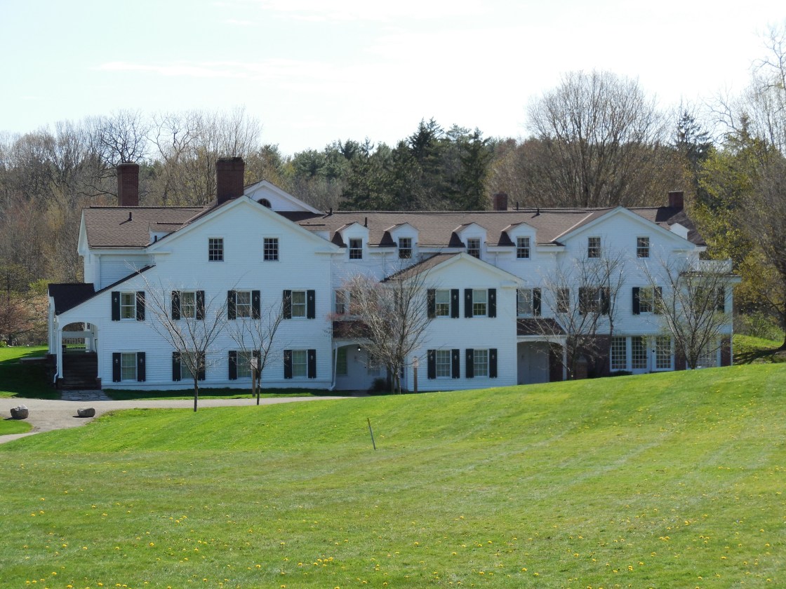
Description: Unlike most of the lakes we run across while researching and exploring, Congress Lake is natural and was formed by an ice age glacier. The section of the lake where the ghost town is was in what was called the Congress Lands just south of the Connecticut Western Reserve prior to Ohio becoming a state. Revolutionary War veteran Conrad Brumbaugh (1768 – 1859) from Frederick County, Maryland acquired a large farm on the east and south sides of the lake. After his first wife Elizabeth (Miller) Brumbaugh (1770 – 1805) passed away in Pennsylvania, he married Catherine (Markley) Brumbaugh (1779 – 1855) in 1806. She was one of Elisabeth (Markley) Bixler’s sisters and was also born in Maryland. The Brumbaugh’s original two-story log cabin was completed in 1820. The family built a much larger house and barn for their new residence in 1842. It also had a summer house and a nice courtyard. Conrad and Catherine were laid to rest with relatives and other residents in the cemetery. William and Mary Rubright purchased land in the area in 1867 and built the first section of the Manor House. Harry and Minnie Stewart bought the land in 1901 and expanded the house to 40 rooms from 1914 – 1929. The park conducts several tours of the house from May through October. Congress Lake had a train station on the Cleveland, Canton, & Southern Railroad, later bought by the Wheeling & Lake Erie Railroad. The station closed in 1939. Quail Hollow Park at 13480 Congress Lake Ave NE Hartville, OH 44632 has many recreational activities among the historical remnants of the past. Whether paying to play or exploring for free, there’s plenty to check out and do.
Park Info – https://starkparks.com/parks/quail-hollow-park/
Danzig
Location: unknown
Description: none found
Floradora – Jackson Township
Location: unknown
Description: none found
Geibe (Geib) – Lake Township
Location: 40.940985, -81.336993
on SR 43 (Kent Ave NE) at the intersection of Smith Kramer St NE
Remnants: none known
Description: The town was founded by Samuel Geib (1827 – 1917) from Lancaster County, Pennsylvania and Susannah (Brown) Geib (1819 – 1869). They were married in 1848 and had 7 children. Samuel married Catherine (Wise) Geib (1840 – 1917) after Susannah passed away and had 6 more children. He was a farmer, lawyer, and served as county treasurer for a short term. The town had a school, blacksmith shop, and a church, but was declining in status by the time the Cleveland, Canton, & Southern Railroad arrived in the later 1800s. Susannah Geib was buried with relatives in Hartville Lutheran Cemetery 2 miles north of town on the south side of SR 619 (W Maple St) in Hartville. Samuel and Catherine were buried in St. Mary’s Cemetery on Mill Rd in Ravenna, Portage County.
Glaris – Paris Township, Stark County and West Township, Columbiana County
Post Office: dates not listed
Location: unknown
Description: It was mentioned in The Ohio Gazetteer and Traveler’s Guide as a small postal town 16 miles east of Canton.
Hamburg – Sandy Township
Location: 40.677358, -81.261033
on SR 43 at the intersection of Goodland St SE
Remnants: none known
Description: Jospeh Handlon platted Hamburg on the north side of Sandy Creek in the early 1800s. It had a general store owned by a man with the last name Pool and a school on the Boyd farm. The town failed to attract enough residents though and was subsequently abandoned. Joseph then platted Waynesburg on the south side of the creek in 1814 – 1815, naming it after the famous General “Mad” Anthony Wayne (1745 – 1796). Waynesburg did much better and has since overtaken the land where Hamburg once was.
Hardscrabble – Canton Township
Location: 40.745752, -81.315730
on Waynesburg Dr SE between Argyle Rd SE (169) and Otto St SE
Remnants: none known
Description: Hardscrabble was more of a hamlet or neighborhood than a town and wasn’t listed on most maps. The area was called Pleasant Vale in the early 1870s and Pleasant Hill was north of the GPS coordinates at the intersection of Waynesburg Dr SE and Argyle Rd SE with a school in its southwest corner.
Lonas (Smoketown) – Bethlehem Township
Location: 40.672639, -81.538891
on SR 21 (Erie Ave SW) at the intersection of Crestline St SE (309)
Remnants: St. Paul United Church of Christ (Reformed) and Cemetery in the northwest corner of the intersection
Description: The town was founded by John Lonas (1811 – 1879) and Leah (Huntsberger) Lonas (1816 – 1877). They moved to Ohio from Virginia in 1839 and had at 10 children who survived to adulthood. Lonas had a steam-powered saw mill in the lot on the northeast side of the GPS coordinates owned by David Leighley (1811 – 1884) from Pennsylvania and Terracy Leighley (born c. 1816) in Ohio. There was a school south of the GPS coordinates on the east side of SR 21 on land owned by the Kucher family and a blacksmith shop and general store in the vicinity. St. Paul’s congregation formed in 1835. Its first church structure was built in 1845 at the same spot and was destroyed by fire in 1913. The congregation disbanded in the 1990s and the present brick church was added to the National Register of Historic Places in 2006. The last member and property owner, Howard Keith, took care of the church after it closed. Its unknown when the town name changed, but Howard’s parents Clyde and Ida Keith owned a gas station there after it started going by Smoketown. It also had a few other small businesses that have since closed. Smoketown is still a populated place and is listed on Google Maps. The Lonas and Leighley (Leighly) families were buried with other early pioneers and longtime residents of Lonas and Smoketown.
Marchand – Jackson Township
Post Office: 1861 – 1916
Location: 40.881519, -81.428025
Remnants: former train station west of the GPS coordinates on the south side of Portage St NW next to the railroad tracks
on Portage St NW at the intersection of Freedom Ave NW
Description: The original proprietors were Joseph Francois Marchand (1825 – 1889) and Catherine (Pierson) Marchand (1829 – 1915). Their parents, along with 3 year old Joseph at the time, immigrated to the U.S. from France in 1828 on the same boat called Le Voltaire. Joseph and Catherine married in 1847 and had 11 children. The Marchand family owned a grain business and the Pierson family owned a lumber company. Together in th 1870s, they attracted the Cleveland Terminal & Valley Railroad (later bought by the B&O) to run its tracks through the area. Its former train station is now a business. The town had a school on the north side of Portage St NW near current-day I-77 and another one on the west side of Whipple Ave NW on the south side of town. The Marchand’s oldest son, Joseph (1850 – 1916), took on proprietorship of the grain business and town after his father passed away. He was the postmaster from 1900 until his death. The Marchand and Pierson families were buried in St. Pauls Cemetery at the intersection of Church St SW and Rose Ct SW in North Canton.
Marks – Onasburg Township
Location: 40.758460, -81.280810
on Indian Run Rd SE (151) between Orchard View Dr SE and Mapleton St SE (118)
Remnants: old houses and farm buildings in the area
Description: The town was founded by Jacob Marks Sr. (1794 – 1882) and Elizabeth (Carl) Marks (1793 – 1880). They moved to Ohio from Pennsylvania, were early pioneers of the county, and had 6 children. At the time of his death, Joseph was the oldest man in the township. The Marks family, along with several others in the area, donated land for the track bed of the Cleveland, Canton, & Southern Railway which ended at Marks. The town had a school on the west side of Indian Run Rd SE north of the GPS Coordinates on land owned by Jacob Marks Jr. (1824 – 1886). Jacob and Anna were buried with relatives in Union Cemetery about 2 miles north of the GPS coordinates at the intersection of Church St W and Berger St S in East Canton.
New Guinea – Lexington Township
Location: 40.944817, -81.100964
on US 225 (Union Ave NE) at the intersection of Armour St NE
Remnants: none known
Description: New Guinea was an African American town of freed and runaway slaves, some of which made the journey to the area with Quaker settlers from Virginia. It was founded around 1810, at least made it through the 1830s, and probably a while longer after that. Historical records indicate the town moved a couple of times. It was originally along the Mahoning River about a mile east of Williamport in Smith Township, and later was near the GPS coordinates north of Williamport. It had a church, school, and around 200 residents. Most of them moved to Defiance prior to the Civil War to get further away from the Underground Railroad and the perils associated with it.
New Winchester
Location: unknown
Description: none found
Nimishillentown – Nimishillen Township
Location: 40.829707, -81.250563
Remnants: none known
Description: It was a platted in the first decade of the 1800s by lawyers Penticost & Scott in the southeast quarter of section 28 in present-day Louisville. They had hopes of it becoming the county seat of newly formed Stark, but none of the lots sold.
Northwood – Jackson Township
Location: 40.842057, -81.500094
on SR 241 (Wales Ave NW) at the intersection of Northwood St NW
Remnants: none known
Description: none found
Otterbein
Post Office: 1897 – 1903
Location: unknown
Description: It was listed on the Ohio map in the 1901 George Cram atlas.
Pauls – Lawrence Township
Location: 40.846168, -81.554010
on the Olde Muskingum Trail along the railroad tracks between Great Lakes Blvd NW and the Tuscarawas River
Remnants: none known
Description: Pauls was on the Cleveland, Lorain, & Wheeling Railroad at what used to be the northern end of Beaumont Ave NW past where it currently ends. The town had a school at the intersection of Beaumont Ave NW and Forty Corners Rd NW. Many residents were employed at a sandstone quarry. The stone was ground into sand for glass production in Pittsburgh.
Pinn – Tuscarawas Township
Post Office: 1896 – 1899
Location: 40.779474, -81.603535
on SR 93 Manchester Ave SW at the intersection of Sinclair St SW (339)
Remnants: Sixteen Church Cemetery north of the GPS coordinates on the east side of SR 93
Description: This small farming town had a school in the southeast corner of the intersection and a previous structure at Sixteen Saint John’s (Reformed) Church. Some residents were buried in Sixteen Church Cemetery. Pinn lasted a lot longer than its post office and was listed in the 1920s county atlas.
Pleasant Valley – Paris Township
Location: 40.780050, -81.152625
on Pleasant Valley Dr SE between SR 172 (Libson St NE) and Baird Ave SE (109)
Remnants: former railroad trestle abutments at the GPS coordinates
Description: It was on the Lake Erie, Alliance, & Wheeling Railroad and had a school at the intersection of Baird Ave SE and Freed St SE (118).
Rocket
Location: unknown
Description: none found
Rome – Nimishillen Township
Location: 40.853000, -81.193967
on Paris Ave NE at the intersection of Kenmore St NE
Remnants: none known
Description: Rome was a small farming town along the Pittsburgh, Ft. Wayne, & Chicago Railway (Panhandle Route) in the mid to late 1800s.
Shaffers – Washington Township
Location: 40.874730, -81.147010
on Bayton St NE (100) at the former railroad crossing between Devonson St NE (98) and Frederick Ave NE
Remnants: none known
Description: The proprietor was Joseph Shaffer (1846 – 1919) who donated land for a train station on the Lake Erie, Alliance, & Wheeling Railroad. He was a farmer, livestock raiser, and a descendant of township pioneers William Shaffer (1775 – 1858) and Sophia Shaffer (1778 – 1858). They arrived in Stark County from Pennsylvania around 1815. Joseph was buried with relatives 3 1/2 miles northeast of town in Mount Union Cemetery on SR 183 (S Union Ave) in Alliance. William and Sophia were buried with relatives south of town in Greenlawn (Salem Church) Cemetery at the intersection of Salem Church St NE and Beechwood Ave (26).
Sherwood – Tuscarawas Township
Location: 40.805395, -81.554687
on Bison Ave NW along West Sippo Creek at the former railroad crossing between Wooster St NW (341) and Rolling Park Dr S NW
Remnants: none known
Description: It was on the Wheeling & Lake Erie Railroad and had a school on the north side of town on the west side of Beaumont Ave NW. The former railroad path is now a paved recreational trail with parking access in the southwest lot at the GPS coordinates.
Stark
Location: unknown
Description: none found
Summit – Tuscarawas Township, Stark County and Sugar Creek Township, Wayne County
Location: 40.804914, -81.648129
on Deerfield Ave NW at the former railroad crossing between Krug Rd (Township Hwy 148) and SR 172 (Lincoln Way W)
Remnants: Pleasant View Church Cemetery at the intersection of Wooster St NW (341) and Alabama Ave NW (Co Rd 314), former one-room schoolhouse across the road, old houses and farm buildings in the area
Description: Summit was a small farming town on the Wheeling & Lake Erie Railroad. The Horst family owned much of the land in the area in the late 1800s. Descendants of the family still live close to the GPS coordinates. Most of their ancestors were buried in Pleasant View Church Cemetery northeast of the GPS coordinates just across the border in Lawrence Township. Amos Horst (1864 – 1898) and Anna (Eschliman) Horst (1861 – 1907) donated the lot for the church. The cemetery was previously established on their land. Christian Nolt Horst (1786 – 1860) from Pennsylvania and Barbara (Myer) Horst (1785 – 1876) were the earliest members of the family in the area. Christian was married 3 times and had several children. His first 2 wives passed away before he moved to Ohio. There are also many members of the Eschliman family buried in the cemetery. The town’s former school across the road from the church is now a private residence.
Toy Town
Location: unknown
Description: It was founded by a branch of the Toy family in the county.
Washington – Washington Township
Location: 40.842585, -81.148267
on Hartzell Ave NE (105) between Salem Church St NE and Beechwood Ave (26)
Remnants: none known
Description: This very small farming town had a train station on the Lake Erie, Alliance, & Wheeling Railroad. Its thinly laid plat can be found in the 1896 county atlas and sat between Hartzell Ave NE and the former railroad track bed to the west. It appears that the lots didn’t sell, but Washington did make it into the 1920s county atlas before falling into obscurity shortly after that. The road was named after Jacob Hartzell (1805 – 1884) from Pennsylvania and Catherine (Wharton) Hartzell (1809 – 1889) from Columbiana County. They had 11 children and a large farm north of the GPS coordinates. Joseph and Catherine were buried with relatives in Salem (Wildwood Chapel) cemetery about 11 miles south of town at the intersection of Hein Ave SE and Latin Rd NW in Onasburg Township.