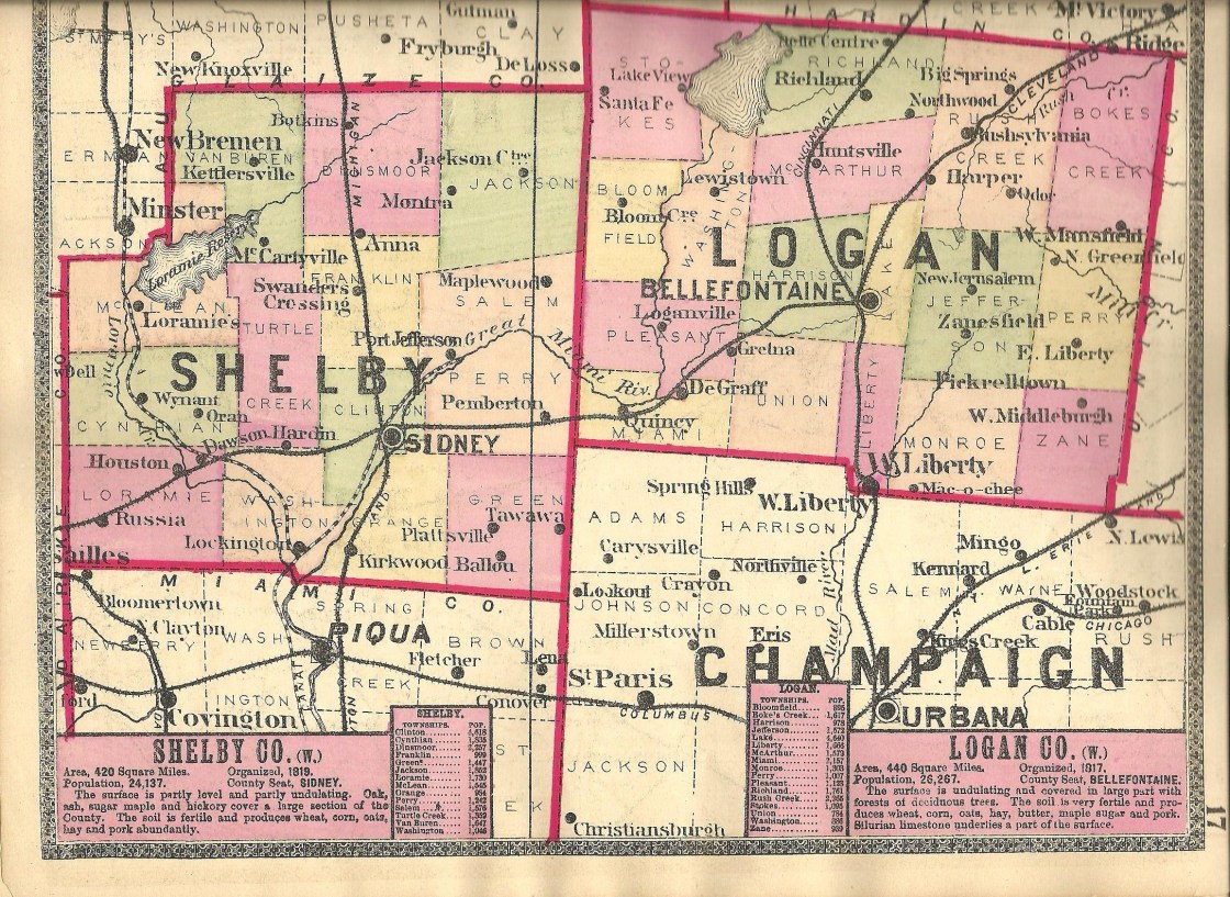
Basinburg – Cynthian Township
Location: 40.327459, -84.371401
on the east side of SR 66 along Loramie Creek
Remnants: none known
Desccription: Basinburg was platted with 65 lots in 1839 by German immigrant Herman Meyers (1775 – 1854). It was named after a basin which expanded out from the Miami & Erie Canal forming a small lake that was used for ice production during cold months throughout much of the 1800s. In 1853 when the state implemented the sub-district school system, Basinburg was the name applied to the area covering Cynthian Township sections 18 where the town plat was, 13, 19, and 24. The town itself never grew much though despite having a decent location. It wasn’t pinpointed on the 1865 county map, indicating it was pretty much considered failed by then. Railroads were taking most of the transportation business that the canal was intended to be built for and Basinburg missed out on the railroad boom with no tracks running through township. Herman Meyers was buried in Mills Cemetery about 4 miles south of the GPS coordinates on the east side of Mills Rd. His surname was originally Mier and changed to Meyers at some point during his lifetime.
Cynthian – Cynthian Township
Location: 40.289859, -84.371901
on SR 47 at the intersection of SR 66 along Loramie Creek
Remnants: none known
Description: It was platted in 1819 and several of the lots sold. There wasn’t enough residents to organize a governing body though and the town was abandoned in 1825 with the area subsequently reverting back to farmland.
Dingmansburg – Clinton Township
Location: 40.284094, -84.148929
on SR 29 (East Court St) at the intersection of High St along the Great Miami River
Remnants: none known
Description: Dingmansburg was the first village in the township. It was platted in 1816 with 18 lots on 3 streets by War of 1812 veteran Daniel V. Dingman (1782 – 1861) from New Jersey. He was also the first sheriff of Shelby County in 1819 and married Margaret (Wilson) Dingman (d. 1847) that same year. They had 10 children and owned 1041 acres of land with 401 surrounding Dingmansburg and the other 640 in Salem Township. The town was replatted as East Sidney in 1837 and annexed into Sidney in 1919. It was never abandoned, but there are no known remnants left from the days when Dingmansburg existed. It’s also unknown where Daniel and Margaret were buried.
Hageman – Green Township
Location: 40.208321, -84.077508
on Dorsey – Hageman Rd at the intersection of Kirkwood Rd
Remnants: none known
Description: The town was founded by John P. Hageman (1830 – 1916) who arrived in the area from Hamilton County in 1850. Along with 2 of his brothers, William and George, John built a steam-powered saw mill in the southeast corner of the intersection in 1854 and operated it for several decades. The building was 50 x 36 feet with a 32 horsepower engine and an upright saw which produced about 2,500 feet of lumber per day. John married Elizabeth (Robinson) Hageman (1834 – 1908) in 1859 and had 4 children. There were a couple of local schools pinpointed on the 1865 county map. One of them (Green Township No. 1) was a mile southwest of the GPS coordinates on the west side of Wiles Rd. The other school (Green Township No. 5) was 1 1/2 miles northeast of the GPS coordinates in the southeast corner of the intersection of Middleton – Hume Rd and Leatherwood Creek Rd. Green Township No. 1 was replaced by a newer building just south of the original location in the northeast corner of the intersection of Wiles Rd and Suber Rd prior to publication of the 1875 county atlas. Green Township No. 5 moved to the northwest corner of its intersection prior to publication of the 1900 county atlas. John enlarged the mill in 1880 and swapped the old engine with a 40-horsepower unit running 2 circular saws. The changes increased production to 8,000 feet of lumber per day and employed more residents. Other items sold by the company included lath boards for houses, picket fence boards, and wagon supplies. John and Elizabeth were buried with many relatives about 2 miles north of the GPS coordinates in Plattsville Cemetery on the west side of Leatherwood Creek Rd (Township Hwy 152).
Hale – Cynthian Township
Post Office: 1838 – 1842
Location: 40.299594, -84.386639
on the northwest side of Kaiser Rd along Loramie Creek
Remnants: none known
Description: This small farming and postal town was founded by George Hale (1799 – 1855) and Maria Hale (1808 – 1845). They moved to the township from Pennsylvania in 1837 and had at least 6 children. George’s mother Betsey (d. 1839) also made the journey to Ohio. The town was along Salt Lick and the Miami & Erie Canal just northwest of the GPS coordinates with J. C. Robinson serving as the only known postmaster. George and Maria were initially buried with Betsey and their departed children in Mills Cemetery about 2 1/2 miles southeast of the GPS coordinates on the east side of Mills Rd. The Hales endured many hardships concerning early deaths. According to the inscriptions on their original tombstones, the majority of the children passed away in their teens and 20s. Most of the family was reinterred in Graceland Cemetery on S Main Ave (County Hwy 25A) in Sidney.
Northumberland – Dinsmore Township
Location: 40.453041, -84.180300
on Sidney – Wapakoneta Rd at the intersection of Lock 2 Rd along Loramie Creek
Remnants: Old Loramie Valley Cemetery in the southwest corner of the intersection, New Loramie Valley Cemetery on the east side of Sidney – Wapakoneta Rd just north of the intersection
Description: The town was founded by settlers from Northumberland County, Pennsylvania. Most of them were German immigrants. It never had stable growth and faded into oblivion prior to publication of the 1883 county history book.
Saint Patrick (St. Patrick) – Turtle Creek Township
Post Office: 1893 – 1904
Location: 40.370942, -84.287550
on Hoying Rd (Co Hwy 79) at the intersection of Wright Puthoff Rd (Township Hwy 86)
Remnants: Saint Patrick Cemetery at the GPS coordinates, historical marker next to the cemetery at the former church site, old houses and farm buildings in the area
Description: The town of Saint Patrick grew around its Catholic church congregation which was established in 1862 by residents mostly of Irish descent. It’s still a populated place and an unincorporated community, but the public buildings are gone and there’s just about a dozen residences left in the area. The original log church was constructed in 1863 on land owned by the Brenner family. It was replaced with a wood frame structure in 1871 and subsequently a large brick church in the 1910s which was added to the National Register of Historic Places in 1979. The church was demolished in the 1990s. Saint Patrick also had a school across Hoying Rd from the church. It first appeared in the 1875 county atlas and was replaced by a brick parish school in 1906. Herman H. Barhorst (1862 – 1908) was the first postmaster. He was buried with relatives and other residents in the cemetery. Richard A. Thaman (1871 – 1948) was the last postmaster. He was buried with relatives in Graceland Cemetery about 12 miles southeast of town on the west side of S Main Ave (Co Hwy 25A) in Sidney.
Thanks to Rufus Defibaugh for the lead on Saint Patrick!
Valentine – Green Township
Location: 40.222000, -84.058198
on SR 589 at the intersection of Middleton – Hume Rd (County Hwy 155)
Remnants: none known
Description: The town proprietor was William F. Valentine (1865 – 1936) from De Kalb County, Indiana who was a farmer and bought the only tile mill in the township. The mill was in the northwest corner of the intersection. There were also a couple of local schools, Green Township No. 5 in the northwest corner of the intersection of Middleton – Hume Rd and Leatherwood Creek Rd (Township Hwy 152) and Green Township No. 6 on the north side of Sidney – Plattsville Rd between SR 589 and Tawawa – Maplewood Rd. William was married twice, had 5 children, and was buried with his second wife Nelly (Duffy) Valentine (1872 – 1941) and many relatives in Cedar Point Cemetery about 6 miles northwest of the GPS coordinates at the intersection of SR 29 and SR 706.
Rumley, OH (1837 – present farming and livestock town mostly abandoned over time for various reasons)
Classification: semi-ghost town
Location: Van Buren Township, Shelby County – On Hardin – Wapokeneta Rd south of the intersection with Blanke Rd
We ran into several inconsistencies while researching Rumley and will attempt to address all of them in this sketch to sort out some of the confusion. The deeper we dug, the more questions arose, but further research revealed that each of those questions only have a couple of possible answers.
The first settler was Colonel Amos Evans, who probably achieved his rank in the War of 1812, and built a log cabin, general store, and tavern in the early 1830s. A few more families moved to the area and then Joel Weslin (also known as Jacob) Goings (Goins) (1799 – 1872) and his brother John (also known as George) Wesley Goings (Goins) (1795 or 1796 – 1848) arrived around 1832 from Guernsey County. They purchased 400 acres of land in what would become Rumley and had lots of plans for it. Some have stated they were free black men from Baltimore, Maryland but genealogy records indicate they were from Virginia. Joel is also said to have been a member of the native Wappoo tribe in early historical records though, and both may have been of mixed descent. Joel married Elizabeth (Cole) Goings (1808 – 1869) who was from an Irish family and they had 11 children. German immigrants made it to Rumley in 1834 and later more European settlers from colonial states, black, white, native American, and some freed or escaped slaves moved there.
“Joel and Wesley” Goings built several businesses including a grocery store, hotel, and a brick plant. Joel also owned a horse powered saw mill with Elias Spray. Colonel Amos Evans platted the town in 1837 with 48 lots and a post office ran from 1839 – 1842. Joel and Elizabeth constructed the first brick house in 1841. Rumley was turning into a bustling community serving well as a stagecoach stop between Piqua and Lima. It was also platted along an old native trail which was used for the Underground Railroad.
Rumley flourished through the mid-1800s with schools, churches, and several saloons, hitting a peak population of about 500. There was about 50 residents in town and 450 on the outskirts. The Goings 2nd generation did well in Rumley too. It’s been stated that 385 emancipated slaves from John Randolph’s (1773 – 1833) plantation in Virginia settled in Rumley, but the majority of them were actually turned away as the town couldn’t support so many new citizens at one time. Another big part of the problem was getting legal papers for all of the migrants to prove they weren’t runaway slaves. After a long journey from Virginia with a stop in Miami County for a few years (Hanktown), some did end up in Rumley. A few others scattered around Shelby and Mercer County, but most of them returned to Miami.
The town was doing fine up until the Civil War. Racial tensions had driven away some of the residents and was the reason for the first decrease in population. In the 1870s and 1880s, improvements in farming and machinery led to a second exodus of citizens to other towns that had more jobs and newer equipment to work with. Rumley got passed up by the railroads too, the Chesapeake & Ohio being 5 miles east, making commutes in and out of town seem difficult in comparison. In the 1900s The Great Depression was the final straw for any hopes of a new boom to Rumley. Some residents stuck around and the town never lost its name, but also would never quite be the same again.
These days, the total number of people who would say they live in Rumley is probably down to around 50. The last school the town had was built in the 1890s. Its been restored as a meeting hall and sits at the corner of Blanke Rd and Hardin – Wapokeneta Rd. Some residents also attended the Wenger School constructed in the late 1860s at 11385 Amsterdam Rd, a few miles northwest of town. Rumley Baptist Church, built in the 1880s is, south of the Rumley School on Hardin – Wapokeneta Rd and has a historical marker for the town. Despite the factual inaccuracies on the marker, at least something is there and we’ll leave it at that. Burials took place at 4 local cemeteries. Joel and Elizabeth Goings were buried with some of their family members in Collins Cemetery on the north side of SR 274. There’s an abandoned house or two around Rumley, but the main reason for classifying it as a semi-ghost town was the massive population decreases and number historical buildings still standing.