
Amsterdam (New Amsterdam) – Paint and Paxton Township, Ross County and Paint Township, Highland County
Location: 39.232373, -83.289902
on Falls Rd along Paint Creek between Rapid Forge Rd and Cove Run Rd
Remnants: none known
Description: Revolutionary War veteran General Nathaniel Massie (1763 – 1813) and Dutch immigrant brothers Jacob and Enoch Smith built a dam together at the falls of Paint Creek in the late 1790s. Nathaniel built a grist mill, distillery, and a small furnace on the north side of the creek and a saw mill on the south side of the creek, while the Smith brothers built a large saw mill on the north side of the creek. The mills went into operation in 1798 and they platted Amsterdam in 1800. Nathaniel didn’t want to compete with the Smith brothers in the lumber industry, so he abandoned his saw mill after building his house and supplying lumber for a few neighbors. Fine farmland along the creek attracted new residents and the town quickly grew with many cabins and a few shops. However, the location was deemed unhealthy and supposedly malaria nightmare. Although those sentiments were mostly boasted by people with interests in other potential town sites. Nathaniel looked for a more favorable site anyway, founded Bainbridge in 1805, and Amsterdam was subsequently abandoned. A historical marker for Nathaniel Massie’s home in Paxton Township is on the south side of US 50 just west of Bainbridge.
Baum Village – Twin Township
Location: 39.266218, -83.149161
on Schlegel Rd between the road and Paint Creek
Remnants: partial earthworks
Description: It was a Native American town attributed to the Fort Ancient culture (1000 AD – 1750 AD) and was named after the Baum family who owned most of the land in the area in the mid to late 1800s. The site is also called “Clark’s Works”, referring to W. C. Clark who owned the land when it was first explored by historians in the mid-1840s. As with all of the towns and earthworks that historians coin as Fort Ancient, Hopewell, or Adena, absolutely nothing about the people who constructed them was known to the Native Americans which European settlers encountered. An interesting point about the Baum Village site is its proximity to Spurce Hill which was a massive stone fortified complex just to the east. The entire top of Spruce Hill, comprising of approximately 140 acres, was walled in and has been attributed to the Hopewell culture (200 BC – 500 AD). Spruce Hill may very well be Ohio’s second biggest mystery, right behind the Great Serpent Mound in Adams County. On the plus side, mysteries like those leave a lot to one’s imagination. For if every bit of history could be explained by proven facts, the world would be a much more boring place.
Bethesda – Paint Township
Location: 39.294017, -83.340166
on SR 41 between Upper Twin Rd and Township Hwy 6h (Cliff Run Rd) along Buckskin Creek
Remnants: former railroad trestle abutment in Buckskin Creek at the GPS coordinates
Description: Bethesda had a train station on the Ohio Southern Railroad.
Brownstown – Deerfield Township
Location: 39.493648, -83.103051
on Browns Chapel Rd between Brown Rd (Township Hwy 132) and Westfall Rd at the confluence of Hay Run and Deer Creek
Remnants: Browns Chapel and Cemetery about 1/2 of a mile south of the GPS coordinates
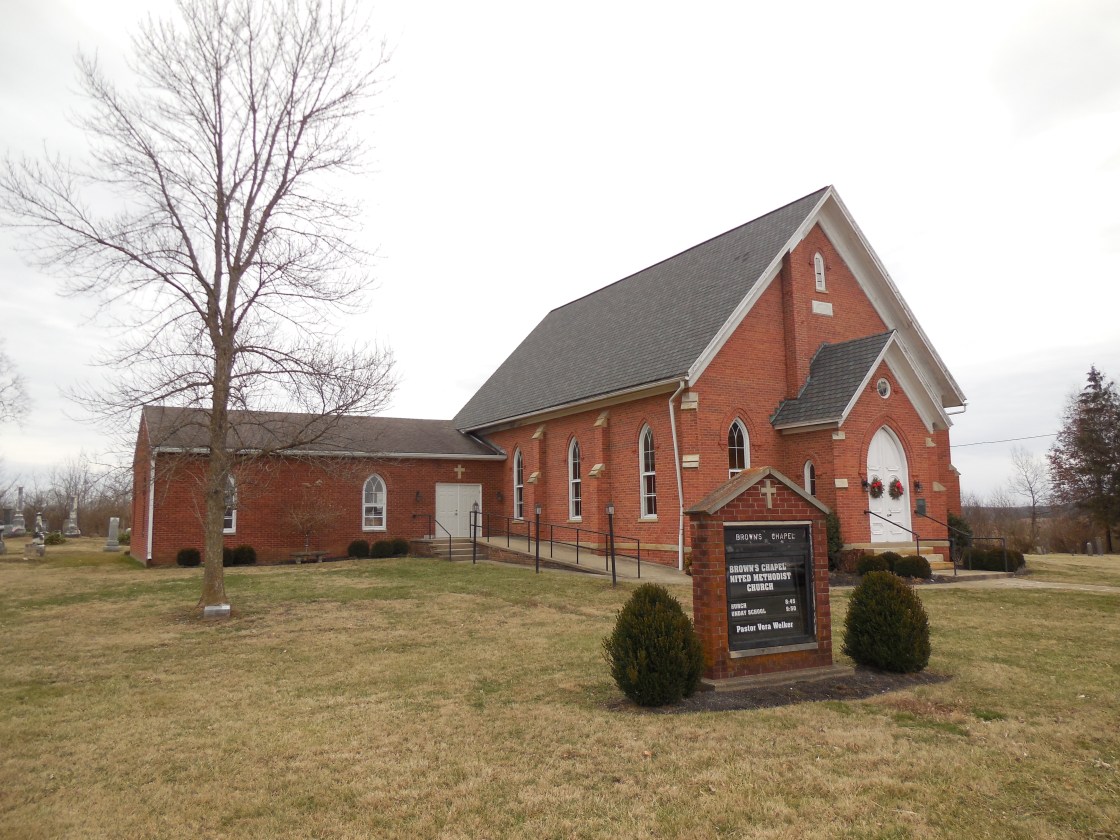
Description: The town was founded by Revolutionary War veteran White Brown (1749 – 1842) from Sussex County, Delaware. White purchased 500 acres of land in Deerfield Township and moved there in 1801 with his sons and 40 slaves which were freed upon arrival in the safety of their new home. White, his sons, and the former slaves cleared the land and raised a crop of corn. A large barn constructed on the Brown homestead in 1803 was used as the first Methodist church in the township. The rest of the Brown family in Delaware joined the family in Ohio that same year. White constructed the first saw mill in the township next to Deer Creek, served as township trustee, and donated the land for Brown Chapel Cemetery in 1805. A grist mill was added to the saw mill in 1815. The barn continued to be used as the church until 1818 when it was replaced with a new structure. Another wood frame structure replaced it around 1835 and the current brick church was completed in 1871. Several generations of the Brown family continued the tradition of milling and farming in the area after White passed away. A mill stone at Brown’s Chapel, which was used in Brown’s Mill from 1815 to around 1870, marks the spot of the original barn church and has a historical plaque with info. The town also had a brick one-room schoolhouse in the late 1800s on land owned by the Hyde family, west of the GPS coordinates on the south side of Brown Chapel Rd at the intersection of Brown Rd. White was married 3 times, had 12 children, and was laid to rest in the cemetery. About 80 of his descendants are currently interred there.
Courtright – Green Township
Location: 39.448326, -82.927444
on Snyder Rd (Towship Hwy 276) at the intersection of Sulphur Spring Rd
Remnants: none known
Description: none found
Ebush – Twin Township
Post Office: 1900 – 1907
Location: 39.311217, -83.120240
on US 50 at the intersection of Blain Hwy (Co Hwy 167)
Remnants: none known
Description: Ebush was a small farming and postal town. William T. Miller (1873 – 1956) from Pike County was the postmaster. He was buried with relatives and other residents in Twin Township Cemetery 2 1/2 miles southwest of the GPS coordinates on the south side of US 50.
Feightner – Colerain Township, Ross County and Salt Creek Township, Hocking County
Post Office: 1893 – 1907
Location: 39.412726, -82.746786
on SR 327 at the intersection of Bull Creek Rd
Remnants: Pleasant Hill Cemetery at the GPS coordinates
Description: It was another small farming and postal town with Ernest L. Feightner (1869 – 1955) being the proprietor and postmaster. He later moved to Franklin County and was buried there with relatives in Green Lawn Cemetery on Greenlawn Ave in Columbus.
Heglers – Concord Township
Location: 39.457111, -83.251312
on Austin Rd (Co Hwy 29) at the crossing of the Paint Creek Recreational Trail south of Old US Hwy 35 along Herrod Creek
Remnants: none known
Description: The town was founded by War of 1812 veteran Colonel Abraham Hegler (1789 – 1865) from Hardy County, West Virginia and Elizabeth (Shobe) Hegler (1790 – 1812). They got married in 1809 and had a few children. After Elizabeth passed away, Abraham married Dorthea (Stookey) Hegler (1792 – 1858) and had a few more children. The family owned well over 1,000 acres of land and continued to engage in farming and livestock raising in the area throughout the 1800s. Unfortunately, the railroad arrived in the area too late to make an impact on the town. Abraham was buried with relatives in Mallow Cemetery 3 miles southeast of the GPS coordinates on the east side of SR 138 south of McCortney Run. The Paint Creek Recreational Trail is a 35-mile paved path that follows the former bed of the Cincinnati, Hamilton, & Dayton Railroad.
New Salem – Buckskin Township
Location: 39.329051, -83.353785
on SR 41 between Moon Rd and Lower Twin Rd
Remnants: old houses and farm buildings in the area
Description: New Salem had a train siding for loading and unloading on the Ohio Southern Railroad in the late 1890s to early 1900s. The former track path is just west of the GPS coordinates and can be been on satellite maps. Any hopes of turning the location into a bustling town were wiped away as the railroad went into foreclosure with passenger service stopping just a few years after it first hit the maps.
Newingberg (Newingburgh) – Huntington Township
Post Office: 1880 – 1907
Location: 39.267948, -83.101343
on Windy Ridge Rd (Township Hwy 159T) between Shady Glen Rd and Blaine Hwy (Co Hwy 167)
Remnants: none known
Description: It was founded by German immigrant Erhart Rueb (1847 – 1923) and Anna (Hechinger) Rueb (1845 – 1923) and was named after Nuenburg, Germany. They got married in 1872 and had a few children. Erhart was the first postmaster. He was succeeded by his oldest daughter, Carrie (Rueb) Corcoran (1873 – 1954). The Rueb family was laid to rest in St. Margaret Cemetery on Worthington Ave in Chillicothe. Adam Cochenour (1871 – 1951) was the last postmaster. He was buried with relatives in Twin Township Cemetery just northeast of Bourneville on the south side of US 50.
Poe Valley – Harrison and Liberty Township
Location: 39.296747, -82.777690
on Poes Run Rd between Skaggs Rd and Cunningham Rd (Township Hwy 524)
Remnants: none known
Description: The town had a school and was named after the Poe family in the county.
Rapid Forge (Rapids Forge) – Paint and Paxton Township
Post Office: 1854 – 1855
Location: 39.236014, -83.340902
on Rapid Forge Rd at the intersection of Falls Rd along Paint Creek
Remnants: Hulitt Cemetery 2 miles northwest of the GPS coordinates on the south side of Deer Park Rd
Description: Richard Hulitt (1762 – 1843) from Monmouth County, New Jersey constructed a grist mill and saw mill on Paint Creek in the first decade of the 1800s. He sold the mill to Thomas James (1776 – 1856) from Virginia around 1815. Thomas built a race and dam on the creek and opened an iron forge in 1817. John Woodbridge (1785 – 1864) from Connecticut and Elizabeth (Buchanan) Woodbridge (1797 – 1861) from Kentucky were the original owners of the town site. They got married in 1816 and had at least 16 children. U.S. Senator John Woodbridge Jr. (1829 – 1876) inherited the land and became an owner of the Rapids Forge Iron Works. The forge suffered a devastating flood in 1852, which destroyed much of its machinery, and the grist mill was destroyed by a fire in 1859. The town also had a company store, school, and a church. It hung on for a few decades after the forge closed, but faded out of existence before 1900. Richard Hulitt was buried with relatives and other residents in Hulitt Cemetery. Thomas James and the Woodbridge family was laid to rest in Grandview Cemetery on Brookside Rd in Chillicothe.
Reeves Crossing (Seymour’s Crossing) – Paxton Township
Location: 39.238535, -83.232759
on US 50 along Paint Creek between Lovers Ln (Township Hwy 30) and Dill Rd
Remnants: none known
Description: Revolutionary War veteran Nathan Reeves (1769 – 1834) settled on the south side of Paint Creek and built a grist mill, tannery, and operated a ferry crossing. Revolutionary War veteran William Kent (1763 – 1849) from Allegany County, Maryland, a brother of Revolutionary War veteran Absolam Kent (1752 – 1839) who founded Brownsville in Harrison County, was paid by Nathan to clear the 40 acres of land that Reeves Crossing was founded on. The town was previously the location of 2 small battles fought with Native Americans in the 1790s. William began clearing the land in 1795 and lived there with his family until 1832. He was buried with relatives in Bainbridge Cemetery on Mountain St in Bainbridge. Nathan also left Reeves Crossing in 1832, selling out to Richard R. Seymour (1806 – 1885) from Hardy County, West Virginia. It then became known as Seymour’s Crossing and had a school on the south side of US 50 near the Seip Earthworks. Nathan Reeves was buried with relatives in Moore Cemetery 10 miles northeast of the GPS coordinates on the south side of US 50 in Twin Township.
Thornton – Buckskin Township
Post Office: 1895 – 1901
Location: 39.392198, -83.324782
on SR 138 at the intersection of Lyndon Rd (Co Hwy 55)
Remnants: Pisgah Church about 1/2 of a mile north of the GPS coordinates on the west side of Lyndon Rd, old houses and farm buildings in the area
Description: It was a small farming town with P. Robinson as postmaster. Pisgah Presbyterian Church was organized in 1811. Its present church structure was built in 1880.
Knockemstiff, OH (Shady Glen or Glen Shady) – (early 1900s – present farming town slowly abandoned over time)
Classification: semi-ghost town
Location: Huntington Township, Ross County – On Shady Glen Rd (Township Hwy 159T) near the intersection of Black Run Rd (County Hwy 156)
There’s not much to see in Knockemstiff aside from a few old buildings, but it had a reputation for being a tough place to work and live. The town had several taverns over the years and bar fights were pretty much a local past-time. We couldn’t find any info about the area prior to it being called Knockemstiff. When it was Shady Glen or Glen Shady, there probably just wasn’t enough around for historians to write about. It was likely originally named after the abundance of local shade trees. The various stories of how the town was renamed Knockemstiff have been disputed but always involve a brawl of some type.
The center of town is near the Shady Glen Church of Christ at the corner of Shady Glen Rd and Black Run Rd. Knockemstiff wasn’t on a 1919 county map, but appeared on maps in the 1940s. Many residents that didn’t farm worked in mills or factories in Chillicothe and making moonshine was also a generational tradition, passed along through families and friends. The population in 1940 was reported around 200 and its peak was possibly as much as 400 in the 1950s. A baseball field was built by volunteers in the 1960s and a couple of bars were still in operation for a few decades after that.
There are a few ghost stories surrounding the town and a couple of books were written by Donald Ray Pollock who grew up there, Knockemstiff (2008) and The Devil All The Time (2011). His parents were the last citizens to run a convenience store in town.
The old Knockemstiff town sign was shot up with bullet holes, and on top of the strange town name, always made passersby wonder about the place. We’ve been told there’s a new town marker that has been put up in recent years.
Thanks to Judy Nichols for helping us improve our research on Knockemstiff! Her grandfather, World War I veteran Fred Darling, reportedly grew up there and is buried in Three Locks Cemetery in Franklin Township, Ross Co. about 15 miles east of town.
Fred Darling Find A Grave Link – http://www.findagrave.com/cgi-bin/fg.cgi?page=gr&GSsr=121&GScid=43733&GRid=40110688
Storms, Ohio (Ross County) – (early 1800s – present farming and railroad town with less residents than in the past)
Classification: small town
Location: on Spargursville Nipgen Rd
Shoults Cemetery on Spargursville Nipgen Rd was established in the early 1800s on land originally owned by War of 1812 veteran John Storm (1790 – 1889) and Diana (DeHart) Storm (1796 – 1866). They both moved to Ohio from Virginia at young ages with their families. Their daughter Elizabeth and her husband James Shoults inherited the land. They were all buried in Storms Cemetery on the west side of Spargursville Nigpen Road south of Sulphur Lick.
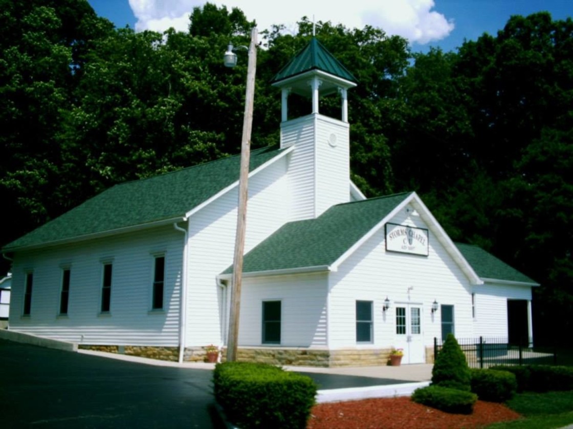
The Storm family donated land for a train station on the Dayton, Toledo, & Ironton Railroad. The town also had a grain elevator, general store, and a post office from 1887 – 1940. Farming was the main industry along with anything else the citizens could do, such as blacksmith work and cabinet making. Storms Chapel on Spargursville Nigpen Road was built in 1897. It’s the last public building left in town and is still in operation.
Tucson, OH (Charleston) – (mid-1800s – present farming and mill town with little growth)
Classification: semi-ghost town
Location: Harrison Township, Ross County – On Charleston Pike (County Hwy 222) at the intersection of Routt Rd
Tuscon was originally called Charleston. It’s unclear where either of the town’s names came from and a lot of its early history is still a mystery. The first big thing that happened there though was when Samuel Wheeland (1811 – 1896) built a steam powered saw mill and corn cracker on Walnut Creek in 1842. It was sold in 1852 to Greenberry Hanson who added millstones to convert it into a regular grist mill. The mill was later sold again to the McGee brothers. Tucson also had a general store, school, a mechanic, about a dozen houses, and a post office from 1890 – 1907. Most of the original settlers were buried in Mt. Carmel Methodist Cemetery, about 4 1/2 miles south of town on Charleston Pike near the intersection of Walnut Creek Rd. Later residents were buried in Charleston Cemetery next to Charleston Church of the Bretheren on Dunkard Hill Rd.

