

Andrews – Washington Township
Location: 40.640359, -82.520006
on SR 13 at the intersection of Andrews Rd
Remnants: none known
Description: The proprietors were Stephen Andrews (1775 – 1861) and Surviah (Carpenter) Andrews (1792 – 1864) who were pioneer farmers and livestock raisers. They moved to Ohio from New York in 1813, had 9 children, and were buried with relatives in Bellville Cemetery on SR 97 in Bellville. The town also had a school (Washington Township No. 5) in the northwest corner of the intersection of SR 13 and Kochheiser Rd.
Condon (Conden) – City of Mansfield (formerly in Madison Township)
Location: 40.768574, -82.567049
on W 4th St at the railroad underpass between N Brookwood Way and N Home Rd
Remnants: none known
Description: It was on the New York, Pennsylvania, & Ohio Railroad on land owned by Benjamin Condon (1843 – 1915) and Luther Condon (1858 – 1916). They grew up on a farm there and inherited the land from their parents Elisha Condon (1807 – 1890) from Pennsylvania and Nancy (Flora) Condon (1816 – 1898) from Maryland who were pioneers in the county. Nancy tragically died from burns she received after her clothes caught fire from a stove spark. Everyone mentioned in this listing was buried with relatives in Mansfield Cemetery on Altamont St in Mansfield. Condon had a school (Madison Township No. 4) in the northwest corner of the intersection of W 4th St and Trimble Rd on land owned by the Trimble family.
Cookton – Springfield Township
Post Office: 1884 – 1903
Location: 40.802631, -82.655951
on SR 314 at the railroad crossing between Hook Rd and Cookton Grange Rd
Remnants: none known
Description: The town was founded by Damsell W. Cook (1832 – 1922) and Anna (Murray) Cook (1841 – 1913). Cookton was on the Pittsburgh, Ft. Wayne, & Chicago Railroad, also called the Panhandle Route, and had a waterhouse for the railroad which is now a pile of rubble on the south side of the tracks east of the GPS coordinates. A school (Springfield Township No. 3) was on the south side of Beam Rd between SR 314 and the railroad tracks. Damsell and Anna were buried with relatives in Shelby – Oakland Cemetery on SR 61 (S Gamble St) north of town in Shelby in Sharon Township. The waterhouse was on land owned by Samuel Brandt (1846 – 1913) and Arey (Musselman) Brandt (1849 – 1922). They were buried with relatives in Greenlawn Cemetery on SR 181 (Crawford – Richland Line Rd) in Crestline in Sandusky Township.
Davis – Worthington Township
Post Office: 1884 – 1903
Location: 40.609239, -82.347673
on Turgend Rd at the intersection of McCurdy Rd
Remnants: old houses and farm buildings in the area
Description: It was a small farming and postal town founded by a branch of the Davis family in the county. John and S. K. Davis owned most of the land in the late 1800s. Robert McConkie (1831 – 1904) was the town’s first known postmaster and was buried with relatives in Bunker Hill Cemetery 2 1/2 miles southwest of the GPS coordinates in Bunker Hill Cemetery at the intersection of SR 97 (Cleveland St) and Bunkerhill South Rd. He was succeeded as postmaster by Joseph M. Hosfeld (1856 – 1909) from Knox County. Joseph was laid to rest in Independence Cemetery 6 miles southwest of the GPS coordinates on the east side of Liberty St in Butler. George E. McConkie (1865 – 1952) was the town’s last postmaster. He later moved out of the state and was buried in Tulare Cemetery on the west side of S Blackstone St in Santa Cruz County, California.
Dew Drop
Location: unknown
Description: none found
Forest – Plymouth Township
Location: 40.959399, -82.686063
on SR 98 at the intersection of Henry Rd
Remnants: former school on the west side of SR 98 north of the GPS coordinates
Descripton: Forest was along the B&O Railroad and had a school (Plymouth Township No. 1) that’s now a private residence. John A. Clark (1865 – 1911) built a small depot next to the railroad tracks that was used a flag stop for passengers. He was buried with relatives in Greenlawn Cemetery on SR 181 in Crestline in Sandusky Township.
Hines (Hinesville) – Sharon Township
Post Office: 1874 – 1906
Location: 40.872058, -82.719834
on Hinesville Rd at the intersection of SR 96
Remnants: Myers Cemetery northeast of the GPS coordinates on SR 39 at the intersection of Davis Rd (Township Hwy 183)
Description: The town was founded by Nickalous Heinz (1821 – 1895) and Margaretha (Stienbach) Heinz (1820 – 1882) who donated land for the track path of the Mansfield, Coldwater, & Lake Michigan Railroad. Their son George Hines (1851 – 1927) and Regina (Metzger) Hines inherited the land and had several children. The family name was Americanized from its Germanic origin to Hines in the mid to late 1800s. The railroad was bought by the Toledo, Walhonding Valley, & Ohio Railroad and the tracks are long gone. Hines also had a church next to Myers Cemetery and a school across the road on the south side of SR 39. The Hines (Heinz) family was buried in Sacred Heart Cemetery on SR 61 south of town in Bethlehem.
Myers – Jackson Township
Location: 40.843112, -82.622951
on Myers Rd (Co Hwy 201) at the railroad crossing between SR 39 and Rock Rd (Co Hwy 150)
Remnants: none known
Description: Adam Myers (1780 – 1855) and Elizabeth (Howard) Myers moved from Lancaster County, Pennsylvania to Stark County, Ohio in 1823. They relocated to Richland County in 1827 and completed construction of their log cabin in 1828. Adam and Elizabeth owned an 80-acre farm, had 7 children, and donated land for tracks of what would later become the B&O Railroad. Pioneer life was tough in the early days and the family even made their own clothes. John D. Myers (1828 – 1914) and Elizabeth (Feighner) Myers inherited the farm and expanded it to 112 acres. John was a township trustee and superintendent of a Lutheran Sunday school for 10 years. Everyone mentioned in this listing was buried in Mt. Bethel Cemetery on the south side of Myers Rd between Plymouth Springhill Rd (Co Hwy 191) and SR 39 east of the GPS coordinates. The Lutheran church was across the road. Myers also had a school (Jackson Township No. 6) at the intersection of Rock Rd and Stine Rd (Co Hwy 169).
Runners (Richland) (Planktown) – Cass Township
Post Office: 1833 – 1838 and 1838 – 1863
Location: 40.957688, -82.585075
on SR 603 at the intersection of Ganges – Five Points Rd (Co Hwy 207)
Remnants: none known
Description: Plantown is still a populated place and has a lot of history that needs sorted out. Runners and Richland are sometimes referred to as ghost towns, but they’re the same location as Planktown. SR 603 was once part of an early 1800s road that ran from Knox County through Richland and up to Lake Erie. It’s most important use was hauling wagons full of grain, usually wheat. Taverns and hotels were also needed along the route for the drivers, oxen, and horses to get much needed rest. David Long (1811 – 1881) had a cabin near the GPS coordinates that was more frequently becoming a stopping place, but he was a tanner and didn’t want to run a hotel. As many as 200 teams of wagons would pass by the cabin on any given day. So David sold his cabin to Michael Runner (1801 – 1850). It was known as Runner’s Hotel at that time. Michael opened a post office in the establishment and owned the first grocery store in the area. John Plank helped run the hotel, was also a postmaster, and bought the hotel from Michael. John platted a town around the hotel in 1837 and originally called it Plymouth, but there was already a village by that name on the Richland and Huron County border. John changed the name to Richland and the post office of that name ran from 1838 – 1863, but residents affectionately called it Planktown. It grew to have around 200 residents with 2 stores and 2 hotels. When the railroad arrived in nearby Shiloh, residents started moving there as it was much more of a bustling community and offered more economic opportunities. Planktown stated turning into a haven for gamblers, bandits, criminals, and lawlessness in general, which drove most of the remaining honest and hardworking folks away over the next couple of decades. By 1880, Planktown didn’t have any businesses left and was down to 7 families. The area never lost its name though and has since been repopulated with newer residences.
Saint Johns – Monroe and Worthington Township
Location: 40.645902, -82.348967
on Covert Rd (Township Hwy 637) off of SR 95 on the north side of Pleasant Hill Lake
Remnants: Saint John Cemetery at the GPS coordinates, stone historical marker for the church just inside the cemetery gate entrance
Description: The town was named after its Evangelical Lutheran church and cemetery that was established on a farm owned by the Darling family. War of 1812 veteran William Darling (1789 – 1855) from Hardy County, Virginia (now in West Virginia) moved to Muskingum County, Ohio with his parents and family in 1806. He settled in Richland County in 1817 and purchased 1,185 acres in one tract and a few smaller farms in other locations. William married Mary (Ravenscraft) Darling (1784 – 1867) and had several children. The church congregation organized in 1838. Its original wood frame structure, completed in 1842, was replaced with a much larger brick church in 1870 at a cost of about $5,000. A stone historical marker in the cemetery was dedicated in 1992 and has a nice pictorial engraving of the church. Over 100 members of the Darling family are interred in the cemetery, including William and Mary. It was spared by nature from potential inundation when Pleasant Hill Lake was created in 1936 for flood control in the area, but much of the former town’s land was submerged by its waters.
Spring Grove – City of Mansfield (formerly in Madison Township)
Location: 40.787434, -82.513363
on SR 13 at the intersection of the southern rd of the Mansfield Correctional Institute
Remnants: none known
Description: Spring Grove was a 55-acre plat addition to Mansfield with expectations of the city stretching north in the future. The land ended up getting purchased by the state during construction of Ohio State Reformatory prison its grounds.
Stewart – Springfield Township
Location: 40.780168, -82.590236
on Lexington – Springfield Rd at the intersection of Ferguson Rd
Remnants: none known
Description: The proprietors were a branch of the Stewart family in the county.
Winchester – Worthington Township
Location: 40.609145, -82.407459
on SR 95 at the intersection of Hagerman Rd along Clear Fork
Remnants: old houses and farm buildings on SR 95 south of the GPS coordinates
Description: Winchester was platted in 1845 by Noble Calhoon (1816 – 1900) and Eliza (Willock) Calhoon (1818 – 1887) as a farming and mill town. It had 2 schools, one in the southwest corner of the intersection at the GPS coordinates, and another on the other side of Clear Fork at the intersection of Wilson Rd and Benedict Rd. A few of the residential lots sold and were improved, but the Calhoons couldn’t keep up with the payments on the land purchase and the remaining property was sold at a sheriff’s auction. The Calhoons did well in life after the failure of Winchester though. They had 3 children and successfully ran a large farm. Noble and Eliza were buried with relatives in Perrysville Union Cemetery on E Church St in Perrysville in Green Township, Ashland County.
Newville, OH – (1823 – 1940s farming and mill town abandoned during a flood control project on the Mohican River)
Classification: small town
Location: Worthington Township, Richland County – On US 95 at the intersection of Pleasant Hill Rd
The town was founded by John Frederick Herring (1767 – 1832) in 1823, a few years after he built a grist mill on Clear Fork Creek. He is buried in Newville Cemetery off of the u-shaped road across from where Pleasant Hill Rd runs into US 95. The town was named after Newville, Pennsylvania where John Herring was born. It grew to have a few stores, several churches, a school, and a post office that ran from 1830 – 1906. Pennyroyal Distilleries also operated near Newville and employed several local residents.
Newville Church was built in 1911 and moved to a less flood prone area. It still sits at the corner of O’Possum Run Rd and Swigart Rd. The demise of Newville becoming a partial ghost town was a two stage process. First the railroads passed it up and instead had stations in Butler and Perrysville, both about 4 miles from Newville. The town population didn’t grow much in the late 1800s and early 1900s. Later in the early 1940s, the U.S. Army Corps Of Engineers advised the remaining residents to leave because a dam that was being built on the Mohican River. There are still some foundations and partial buildings from Newville’s former commercial center left in the woods on the west side of Pleasant Hill Lake.
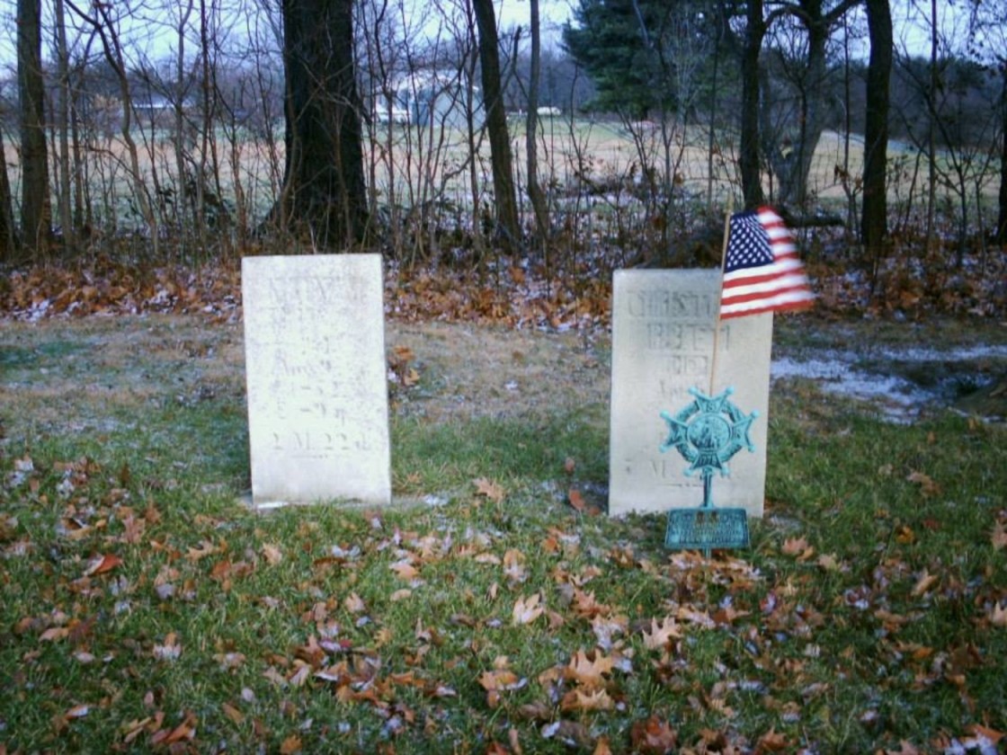
Riblet, OH (Riblet Corners) – Richland County (1830s – 1860s farming town abandoned over time)
Classification: ghost town
Location: Sandusky Township – On SR 309 (Park Ave W) between Horning Rd and SR 181
Revolutionary War veteran Christian Riblet (1761 – 1844) and Christina Magdalene (Shull) Riblet (1763 – 1852) moved from Pennyslvania to Richland County in 1831. They had 4 children including their son Daniel who served in the state senate from 1854 – 1856. The Riblet farm was a well known stagecoach stop for people traveling between Mansfield and Bucyrus. It served as an inn, tavern, and had a post office from 1836 – 1860. The entire town consisted of the Riblet’s farm, a chapel, and a few other farms. The Atlantic & Great Western Railroad, later bought by the Pittsburgh, Ft. Wayne, & Chicago Panhandle Route, ran through the area but there wasn’t enough accommodations around to attract more residents. Christian and Christina Riblet were buried with several of their family members in Riblet Cemetery on the south side of SR 309 about 1/2 of a mile east of Horning Rd close to the Sandusky and Springfield Township border.

