
Beechy Mire – Dixon Township
Post Office: 1833 – 1846
Location: unknown
Description: The town was founded by Irish immigrant John McCaughan (1773 – 1850) who was the postmaster and was a surveyor by trade. John arrived in Philadelphia, Pennsylvania about 1792 and worked as a merchant and school teacher. He married Hannah Jane (Johnston) McCaughan (1781 – died c. 1864) from Tennessee in 1802. They subsequently moved to Trigg County, Kentucky, had 8 children, and lived in house built out of a rock in 1815. The area became known as Rocky Ridge. John acquired most of the county’s land, a total of 3,000 acres, and some slaves in payment for completing surveying duties. The family attended a Presbyterian church and didn’t agree with how slaves were normally treated in those days. Their slaves were welcome to attend church with them and learn how to read and write if they chose to. John freed them sometime around 1830 by giving each a dollar, then selling them land for the dollar to make the transactions legal. He also donated land for a church their purchased area. After that, John and Hannah moved to Preble County and founded Beechy Mire. They relocated to Steuben County, Indiana in the mid-1840s and the Beechy Mire post office moved to Union County, Indiana. John made a trip to Ireland to visit family in 1850 and was injured from a falling accident on a ship during his return voyage. He made it to Rochester, Pennsylvania but died in a hotel room before the next morning and was reportedly interred in Rochester. Unfortunately, an extensive search didn’t reveal the burial locations of John and Hannah.
Belfast – Jefferson Township
Location: 39.837650, -84.758705
on US 40 (National Rd) between SR 320 and Orangeburg Rd
Remnants: none known
Description: Belfast was platted in 1832 with the expectation of a surely continued existence being positioned on the National Road, but it couldn’t compete with Gettysburg which was platted the same year. Gettysburg’s proprietor John Curry (1805 – 1875) was determined to have the best town in the area. It’s unknown if any of Belfast’s lots ever sold. The 1881 county history book indicated that it had “always been a paper town”. Belfast’s last cartographic appearance was on the 1887 county map, likely just for honorary and historical purposes, or the plat maybe hadn’t been officially vacated by the county’s court system.
Claysburg (Claysburgh) – Israel Township
Location: 39.626157, -84.759637
on SR 725 at the intersection of Cramer Rd along East Fork Four Mile Creek
Remnants: none known
Description: Claysburg was platted in 1833 and too close to Fairhaven which had been platted the previous year and was enjoying steady growth. As far as could be ascertained from the history books and maps, Claysburg only ever had a single resident or household at any given time. The first known resident was none other than Gabriel Smith, affectionately nicknamed “Old Gabe”, a freed slave who also lived in Fairhaven’s Bunker Hill House for a while. Gabriel was a member of the Freedom Of Friends Society, helping escaped slaves who were traveling further north. He was listed as a music teacher in the 1850 census with the birth year of 1803 and was widely known for his singing and fiddle playing abilities. Gabriel was reportedly buried in Fairhaven Cemetery, but it appears his gravestone has since been lost to time. The next known resident was a J. Kelley listed in the 1871 county atlas with a house on the southeast side of the GPS coordinates. That same house was owned by Martin Halderman on the 1887 county map, Martha Halderman on the 1897 county map along with Claysburg’s last plat appearance, and James M. Casey (1855 – 1933) as its last owner in the 1912 county atlas. James was buried with relatives in Fairmount Cemetery about 7 miles northeast of the GPS coordinates on N Main St in Camden. The 1915 county history book states as follows. “The town was destroyed, neither by fire nor flood, but, a few strokes of the pen and Claysburgh ceased to exist, for the present owner of the land, tired of paying town taxes on a part of his farms, had Claysburgh wiped off the map”.
Crawfordsville – Jackson Township
Location: 39.787632, -84.706381
on US 35 at the intersection of Crawfordsville Campbellstown Rd (Co Hwy 16)
Remnants: Bonebrake (New Hope) Cemetery on Cemetery Rd a half mile southeast of the GPS coordinates
Description: Crawfordsville was platted in 1842 by Conrad Frey and lost the competition of attracting residents and businesses to nearby New Hope. It was listed as having around a dozen houses in the 1881 county history book and 7 families in the 1915 county history book. The town has since been absorbed by New Hope. Many of Crawfordsville’s residents, including Daniel Strader (1811 – 1895) who lived there the longest, were buried in Bonebrake (New Hope) Cemetery just across the border in Washington Township. The cemetery was named after the family of Reverend Conrad Bonebrake (1791 – 1874) from Pennsylvania and Lydia (Conn) Bonebrake (1800 – 1838) who were early pioneers of the area. They were also laid to rest with relatives in the cemetery.
Ernest (Concord) – Dixon Township
Post Office: 1890 – 1902
Location: 39.714297, -84.769593
on Concord Fairhaven at the intersection of Concord Rd
Remnants: Concord Church and Cemetery just south the GPS coordinates, Harshman Covered Bridge about a mile south of the GPS coordinates
Description: The town was centered around its Christian congregation which formed in 1840 and the original church was a wood frame building completed in 1848 on the east side of Concord Fairhaven Rd next to the cemetery. It was replaced with the present brick structure in 1882 at a cost of over $4,000. William Gregerson was the town’s first postmaster and was succeeded by his wife Marietta “Etta” (Collins) Gregerson (1846 – 1930). The exact circumstances of the reason for that is unknown, but in most of those cases the husband had passed away and the wife either applied herself or was asked to take on the appointment. They got married in Preble County in 1880 and had one son the following year. Marietta was listed as the land owner of a 60-acre farm with a blacksmith shop on the north side of Concord Rd just west of the GPS coordinates on the 1887 county map. They were both likely laid to rest in Concord Cemetery, but we have as of yet been unable to confirm that. Harshman Covered Bridge crossing Four Mile Creek was constructed in 1894 by Everett Sherman (1831 – 1897). It was added to the National Register of Historic Places in 1976 and was restored in 2007 – 2008. Evertt was buried with relatives in Berkshire Cemetery on US 36 at the intersection of Bent Tree Rd in Delaware County.
Hagerstown – Monroe Township
Post Office: 1832 – 1855
Location: 39.909576, -84.607114
on Holtzmuller Rd along Twin Creek at the intersection of Euphemia Castine Rd
Remnants: none known
Description: It had a general store, the first post office in the township, and was bustling community for a couple of decades. The postmasters over the years were Joseph F. Miller, Daniel Ritz, W. C. Clevinger, and Joseph Brown. Hagerstown missed out on the railroad boom with the tracks of the Dayton & Western Railroad getting built just a half mile to the south. Its post office, merchants, and most of the residents moved to Manchester, present-day West Manchester. Hagerstown was last seen in the 1871 county atlas and faded into obscurity by 1880.
Morningstar – Lanier Township
Location: 39.698238, -84.537844
on SR 503 along Twin Creek between Halderman Rd (Co Hwy 97) and Carlton Rd
Remnants: none known
Description: The proprietors were War of 1812 veteran George Morningstar (1779 – 1862) and Elizabeth (Sweitzer) Morningstar (1783 – 1851). They arrived in Preble County in 1817, had 7 children, and owned a successful farm. George and Elizabeth were buried with relatives 3 miles southwest of the GPS coordinates in Eikenberry (Wheatville) Cemetery on Quaker Trace Rd. The Morningstar and Eikenberrry families were related by marriage.
Oklahoma – Washington Township
Location: 39.786545, -84.634976
on US 127 at intersection of SR 726 along Bantas Fork
Remnants: former school on SR 726 at the interesection of Alexander Rd, old houses and farm buildings in the area
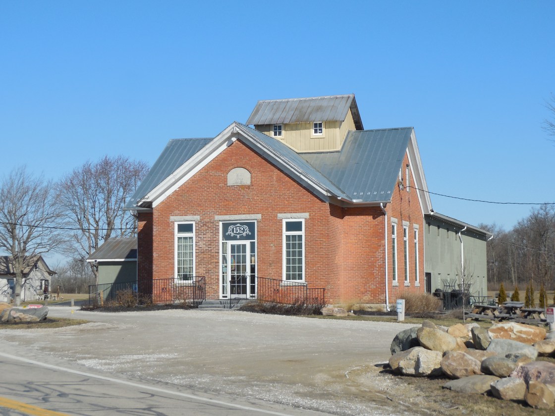
Description: The first known business in the vicinity was a saw mill on the north side of Bantas Fork just east of the GPS coordinates on a 200-acre farm owned by the Risinger family. It was pinpointed in the 1871 county atlas. A steam-powered saw mill was pinpointed on the 1887 county map on the north side of Alexander Rd at the corner of SR 726. The school (Washington Township No. 4) was constructed in 1890 and closed in 1929. It was recently restored and now operates as the Olde Schoolhouse Vineyard & Winery owned by Mark and Angela Zdobinski and Jim and Beth Meeks. Mark and Jim served together on the Preble County Farm Bureau Council. Grapes are grown on the old farm next to the school in the hopes of producing wine from them in the future. Wine tastings are held in the old school and the business occasionally has live entertainment and guest visitors.
Winery Info – https://www.facebook.com/pg/oldeschoolhousewinery/about/?ref=page_internal
Orangeburg (Orangeburgh) – Jefferson Township
Location: 39.838535, -84.746995
on US 40 (National Rd) at the intersection of Orangeburg Rd
Remnants: none known
Description: It was platted by G. Johnson and Thomas Norris prior to Belfast in the same section of the township on the National Road and had a similar story, although Orangeburg actually attracted some residents early on. The 1881 county history book summed up their existences pretty well as follows. “Of Orangeburg it may be said that the town cannot be seen for the houses, and of Belfast, the houses cannot be seen for the town.” Orangeburg peaked with about a half dozen houses and a school (Jefferson Township No. 8) on the west side of Orangeburg Rd north of the GPS coordinates. there was just one remaining when the 1915 county history book was published. The plat had been vacated long before then.
Brinley, OH (Brinley Station) – (1855 – 1902 railroad and farming town)
Classification: small town
Location: Jefferson Township, Preble County – On New Paris – El Dorado Rd about a mile east of Morrison – Mikesell Rd
The only remnant left is the old railroad path that can be seen from the road. The area was settled by John Brinley (1782 – 1827) and Achsah (Harvey) Brinley (1782 – 1865) in 1816. Their son Sylvester Brinley (1816 – 1905) donated land for a train station in 1855 on the Dayton & Western Railroad. He built a general store in 1858 and established a post office that ran from 1860 – 1902. Its name changed from Brinley Station to Brinley in 1882. The Brinley family was buried in Old North New Paris Cemetery at the southern end of New Paris – El Dorado Rd.
College Corner, OH – (1837 – present farming and stagecoach stop town)
Classification: small town
Location: Israel Township Preble County and Oxford Township, Bulter County – On US Route 27 at the intersection of Jones Rd
Gideon Sears Howe (1799-1875) and Sarah (McClay) Howe (1808-1883) purchased a section of land on US Route 27 from Miami University in Oxford in 1832 and built a stagecoach stop with a tavern and inn. They platted College Corner in 1837 and sold the tavern in 1840. Successive owners continued similar operations into the 1970s. The building was added to the National Register of Historic Places in 1976. It’s currently listed on airbnb.com for overnight stays. College Corner was never a large town, but the strategic location on the border with Indiana has always kept it intact. The current population is around 400 residents.
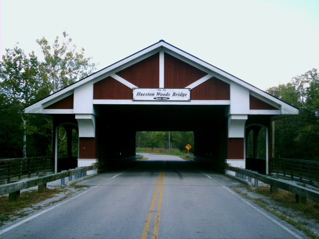
Hueston Woods Covered bridge on Camden College Corner Road was constructed in 2012. It’s 108 feet long and spans Four Mile Creek. This late 1800s wooden replica replaced an aging iron bridge that was built in 1929. The wide road lanes and tall roof clearance accommodate most automobile traffic while pedestrian sidewalks on each side grant access to cross the creek or hang out for a moment to enjoy the view. There’s also a nice picnic area on the east side of the bridge and Hueston Woods State Park offers many activities such as camping, hiking, golfing, and mountain biking.
Fairhaven, OH – (early 1800s – present farming and stagecoach stop town with no growth)
Classification: small town
Location: Israel Township, Preble County – On SR 177 at the intersection of Israel – Somers Rd
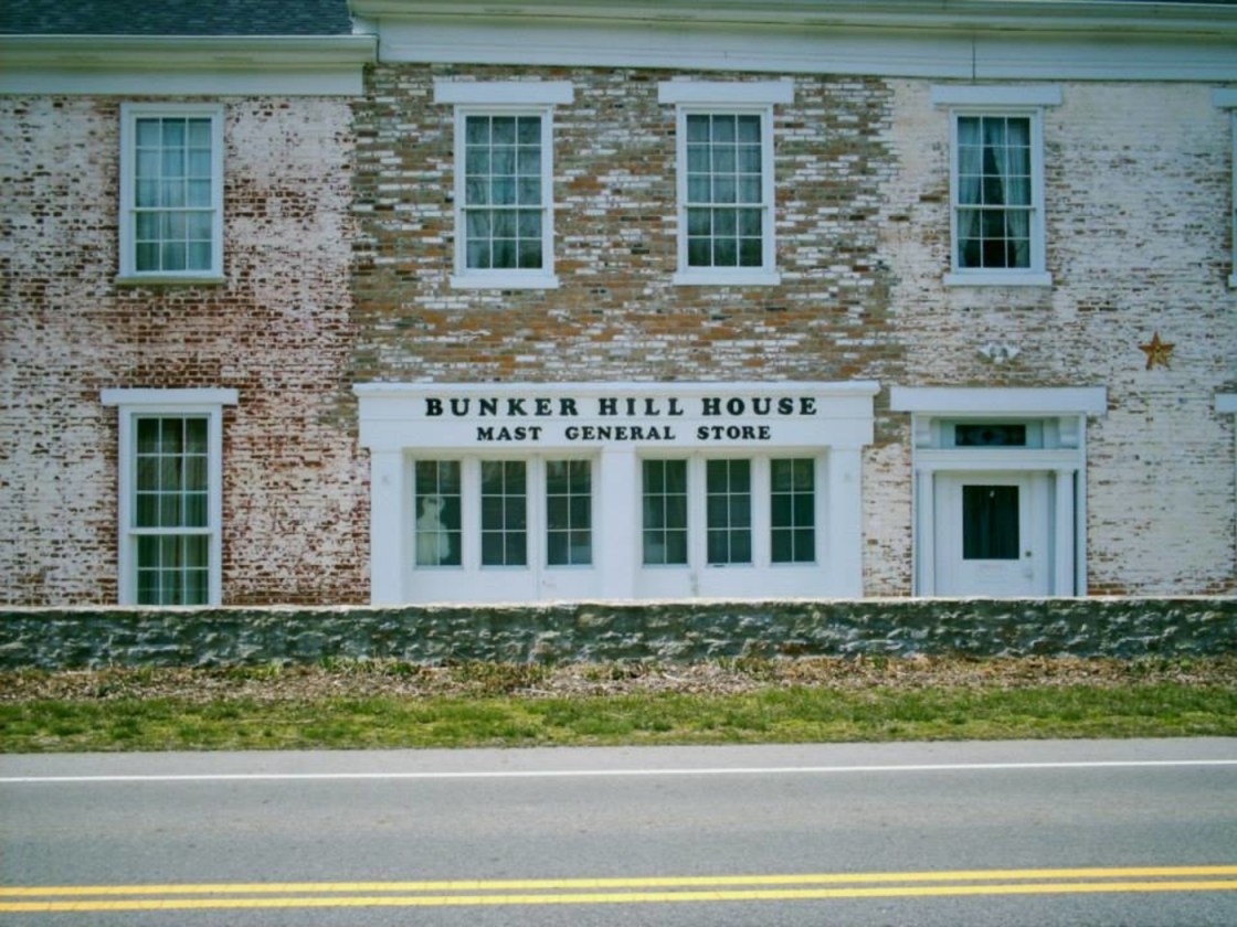
Fairhaven became a town sometime around 1833 when its post office was established. Construction of the Bunker Hill House on SR 177 took place from 1834 – 1838. It was a stagecoach stop on the Hamilton, Fairhaven, & Richmond Turnpike. The massive building served as a hotel and had a tavern until 1858 when a railroad was built through Camden which took travelers past Fairhaven. In 1862 the Bunker Hill House expanded again with a general store.
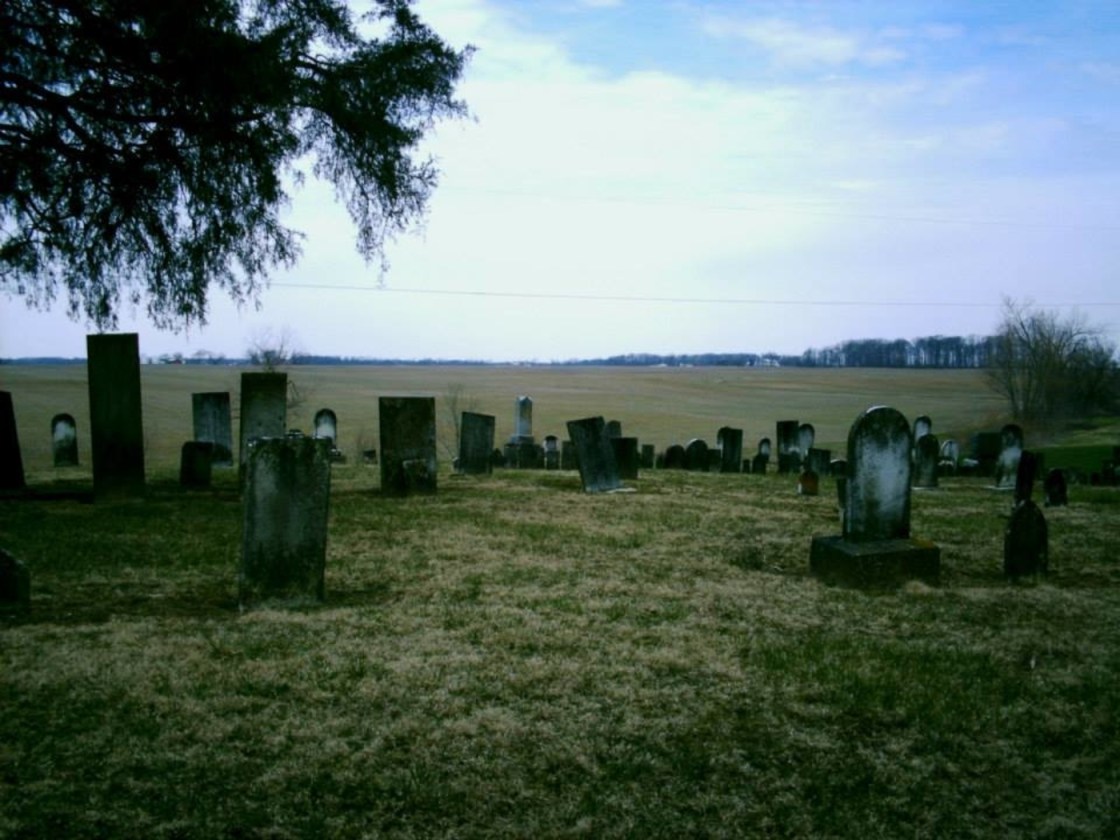
Local resident and freed slave Gabriel Smith was a member of the Friends Of Freedom Society and helped runaway slaves escape from the south during the Civil War. He lived at the Bunker Hill House for a while and hid slaves in his room under a stairway next to the servants quarters. Gabriel was reportedly buried in Fairhaven Cemetery on Israel – Somers Rd. The Bunker Hill House was listed on the National Register of Historic Places in 2001 and is described by Ohio Historical Marker #3 – 68 in its side yard.
The general store closed in the early 1900s and the town lost its post office in 1932. There are also several other old buildings and residences in the area. Harshman Covered Bridge was built in 1894 on Concord – Fairhaven Rd about 4 miles north of town. Its 109 feet long and spans Four Mile Creek. Fairhaven’s population was 273 in 1895. It’s probably smaller than that today and wasn’t included in the 2010 census.
Wheatville, OH – (mid-1800’s – present farming and mill town with less residents than in the past)
Classification: small town
Location: Lanier Township, Preble County – On SR 122 at the intersection of Quaker Trace Rd (County Rd 65)
Wheatville was settled in 1807 by Henry Eikenberry (1771 – 1828) and Mary (Landis) Eikenberry (1772 – 1858). They had 6 kids in Virginia and a seventh child was born in Preble County shortly after they moved there. Wheatville – Eikenberry Cemetery, where most of the Eikenberry family was buried, is on Quaker Trace Rd. There are also several abandoned schools in the area. School #7 is a couple miles north on Halderman Rd, another one is to the east on SR 503, an Andrews Schoolhouse is southwest of town on Aukerman Creek Rd. Wheatville was named after the flour mills that were its major source of income in the 1800s. The town had a post office from 1853-1857.

