Allen’s Corners (Allyn’s Corners) – Hiram Township, Portage County and Troy Township, Geauga County
Location: 41.345379, -81.143172
on Allyn Rd at the intersection of SR 700 (Welshfield Limaville Rd S)
Remnants: old houses and farm buildings in the area
Description: The town was founded by brothers Ozias Allyn (1814 – 1883) and Watson Allyn (1824 – 1903). Their parents, Pelatiah Allyn (1785 – 1856) and Amelia (Taylor) Allyn (1785 – 1867), got married in 1808 and moved to Ohio from Connecticut in the early 1820s. Watson was the first member of the family who was born in Portage County. Ozias and Watson donated land for the proposed Clinton Airline Railroad which was graded and had a track bed made for it but the tracks were never laid. However, the C&W Electric Railroad later rolled through the area in the late 1800s to early 1900s. A school (Hiram Township No. 5) was about 1/2 of a mile south of the GPS coordinates on the west side of SR 700. Ozias served as the commissioner of Portage County from 1865 – 1868. The family surname is spelled as Allen in some branches. Watson and Ozias were buried with many relatives in Fairview Cemetery 3 miles south of the GPS coordinates at the intersection of SR 82 (Twinsburg Warren Rd) and Ryder Rd.
Breakneck – Franklin Township
Location: 41.155641, -81.321510
on SR 59 (Kent Ravenna Rd) at the intersection of SR 261 along Breakneck Creek
Remnants: none known
Description: Breakneck had a grist mill in its early days and there was a school about 3/4 of a mile southwest of the GPS coordinates on the east side of Rhodes Rd in the mid-1800s. The Pennsylvania & Ohio Canal ran through town and was used to ship goods and supplies. Residents were buried in Breakneck Cemetery which was originally 1/3 of a mile west of the GPS coordinates in the southwest corner of the intersection of SR 59 and Rhodes Rd. It was moved to the northeast corner of Standing Rock Cemetery 3 miles northwest of the GPS coordinates on SR 43 (N Mantua St) in Kent.
Cackler’s Corners – Franklin Township and City of Streetsboro (formerly Streetsboro Township)
Location: 41.202836, -81.378368
on Seasons Rd at the intersection of Cackler Rd along Tinkers Creek
Remnants: Cackler Cemetery on private property on the north side of Cackler Rd just west of the GPS coordinates, former Cackler residence in the lot in the southwest corner of the intersection, old houses and farm buildings in the area
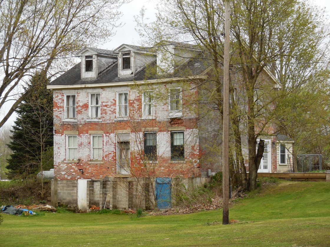
Description: The original proprietors were War of 1812 veteran Christian C. Cackler Jr. (1791 – 1878) and Tharisa (Nighman) Cackler (1791 – 1869) who both moved to Ohio from Pennsylvania with their parents in the first decade of the 1800s. Christian’s parents were Revolutionary War veteran Christian C. Cackler Sr. (1756 – 1830) and Julia Ann (Zediker) Cackler (1759 – 1831). Theresa’s parents were Adam Nighman (1764 – 1835) from Maryland and Elizabeth (Myers) Nighman (1772 – 1840). Christian Jr. and Theresa were married in 1814, the first wedding in Franklin Township, and settled in Streetsboro Township in 1816. They had 12 children, a 370-acre farm surrounding the GPS coordinates, and owned a blacksmith shop in the northwest corner of the town’s main intersection. Christian and Theresa also donated land for the track bed of the Cleveland & Pittsburgh Railroad and a school (Streetsboro Township No. 8) 1/3 of a mile north of the GPS coordinates in the northwest corner of the intersection of Seasons Rd and Ravenna Rd. A private residence is currently in the same spot and appears to likely have been the school, but we haven’t confirmed that yet. Many of Christian’s memories of the county’s pioneer times were documented in a book he wrote in 1870 called Recollections of an Old Settler. The info was used to compile later county history books and was republished under the same title by The Kent Courier in 1904. Christian and Theresa’s last residence was beautifully depicted on page 60 of the 1874 county atlas. It was constructed in 1829 with bricks produced on the property and still stands in the southwest lot of the town’s main intersection. The house and farm were inherited by Christian C. Cackler III (1836 – 1932) and Elizabeth (Bentley) Cackler (1843 – 1919). They got married in 1862, had 4 children, and were buried with relatives in Standing Rock Cemetery about 4 miles southeast of the GPS coordinates on SR 43 (N Mantua St) in Kent. During the time period when Christian III and Elizabeth owned the farm, a granary, large barn, and 2 silos were constructed on the property which all maintain their existence today. Christian Jr. and Theresa were laid to rest with relatives and other residents, including their parents, in Cackler Cemetery. Access to the cemetery is available by contacting the City of Streetsboro.
Cobb’s Corners (Silo) – Mantua Township
Post Office: 1833 – 1850
Location: 41.308670, -81.281175
on SR 82 (Twinsburg Warren Rd) at the intersection of Chamberlain Rd along Aurora Branch
Remnants: none known
Description: Cobb’s Corners predated the present town of Silo at the same location. It was founded by Samuel Cobb (1785 – 1852) and Harriet (Sheldon) Cobb (1793 – 1860). They got married in Connecticut in 1820 and moved to Ohio in 1833. Samuel and Harriet had 3 children, owned a farm of several hundred acres, and Samuel was the town’s postmaster. Their son Henry Cobb (1821 – 1894) helped clear the farm, was a school teacher, and served in several township offices including justice of the peace. He married Antoinette (Taylor) Cobb (1830 – 1912) and 5 children. The school was on the Cobb farm on the west side of Chamberlain Rd just north of the GPS coordinates and was pinpointed on the 1857 county map. As with Allen’s Corners, the proposed Clinton Airline Railroad route ran through Cobb’s Corners with a completed graded bed. Unfortunately, its tracks were merely a dream that didn’t come true. Samuel and Harriet were buried with relatives in East Lawn (Eastlawn) Cemetery 2 miles east of the GPS coordinates on Mantua Center Rd. Henry and Antoinette were buried with relatives in West Lawn (Westlawn) Cemetery 1 3/4 miles east of the GPS coordinates on the north side of SR 82. Cobb’s Corners faded into obscurity by the 1870s. A cheese factory and a mill were in the southeast corner of the intersection of SR 82 and Chamberlain Rd next to Aurora Branch and were pinpointed in the 1874 county atlas. The area’s name switched to Silo in the late 1800s. A new school (Manuta Township No. 4) was on the west side of Chamberlain Rd just north of the former school. Silo post office ran from 1899 – 1904 with George M. Wood (1863 – 1939) as the postmaster and owner of a general store. He was also buried with relatives in Westlawn Cemetery.
East Davis – Edinburg and Charleston Township
Location: 41.130563, -81.121156
on Cable Line Rd at the intesection of Porter Rd in West Branch State Park
Remnants: Elliott Family Cemetery on a ridge off of the Machine Trail in West Branch State Park
Description: East Davis was a small farming town with a couple of saw mills nearby. In the mid-1800s, there was a school 1 1/3 mile west of the GPS coordinates in the northeast corner of the intersection of Cable Line Rd and Rock Spring Rd. A church was in the northwest corner of the same intersection. The Pennsylvania & Ohio Canal ran through the north side of town in Charleston Township. Certain circumstances that weren’t based on historical facts made the Elliots the most well-known family from the area these day. Mulford B. Elliott (1801 – 1878) from New York and Elizabeth (Bowles) Elliott (1801 – 1781) from Pennsylvania got married in 1826, had 10 children, and owned a 100-acre farm on the west side of the GPS coordinates. Their family cemetery was heavily vandalized in the 1970s and 1980s, mostly due to a local urban legend known as “The West Branch Witch”. The legend is completely fabricated. Its basically a campfire story with several alternative versions. Permission from the park is now required to visit the cemetery. A hiking trail labeled as E Davis on Google Maps is on the north side of Cable Line Rd at the GPS coordinates on the south side of the Michael J. Kirwan Reservoir. Some of East Davis’s former land was impounded by the completion of the reservoir in 1966, but the town was long gone by then.
Greenleafs Corners – Charlestown Township
Location: 41.191984, -81.109557
on Greenleaf Rd at the intersection of Ravenna Arsenal Rd along Sand Creek on the grounds of Camp James A. Garfield Joint Military Training Facility (Ravenna Arsenal)
Remnants: none known
Description: The original proprietors were Israel Greenleaf (1813 – 1895) and Emily (Whitney) Greenleaf (1810 – 1883). They got married on New Year’s Day in 1833, moved to Ohio from New York in 1835, and had 5 children. Israel and Emily owned a 75-acre farm on the east side of Greenleaf Rd just south of the GPS coordinates. They bought their son, John Whitney Greenleaf (b. 1836), a 60-acre farm on the north side of the GPS coordinates. Its perimeter can still be seen on satellite maps. John was married twice and had 4 children. His burial location is unknown. A school (Charlestown Township No. 6) was in the northeast corner of the intersection. Emily passed away just 18 days after her 50th wedding anniversary. Israel remarried twice after died. They were buried with relatives and other residents in Charlestown Cemetery 3 1/2 miles southwest of the GPS coordinates on the south side of Newton Falls Rd. Access to town site is restricted. The land was purchased by the U.S. Army in 1940 and was used to for ammunition production during World War II, the Korean War, and the Vietnam War.
Hutson – Deerfield Township
Location: 41.016797, -81.021576
on the Berlin Lake Trail south off of US 224 between Sheffleton Rd and Diver Rd
Remnants: none known
Description: It was founded by Harmon Hutson (1827 – 1906) and Charlotte (Vaughn) Hutson (1837 – 1900). Harmon served in the Civil War as a riverboat pilot captain on the Ohio and Mississippi Rivers. After the war, they bought a 150-acre farm in Deerfield Township and founded the Hutson Coal Co. when the resource was discovered in the area. It employed residents from the mid-1890s to late 1920s. Coal was shipped out of the Alliance & Northern Railoroad (later the Lake Erie, Alliance, & Wheeling Railroad). A couple of the miners, David Reese and Richard Davis, ran into a mineral water spring which was clean enough to bottle for sale. A brick bottling plant was subsequently constructed. The plant also produced sodas, including ginger ale, root beer, cherry, sarsaparilla, and mint nectar. Harmon and Charlotte had one child, a son who died at the age of 11. They were buried with relatives in Deerfield Cemetery about 1 1/3 miles northwest of the GPS coordinates on the north side of US 224.
Julia – Mantua Township, Portage County and Auburn Township, Geauga County
Post Office: 1893 – 1904
Location: 41.347501, -81.223833
on SR 44 (Ravenna Rd) at the intersection of Harner Rd along Black Brook
Remnants: none known
Description: The proprietors were Adelbert D. May (1848 – 1907) and Lillian (Bidlake) May (1848 – 1930). Adelbert was the postmaster and the town had a steam-powered saw mill just southeast of the GPS coordinates next to Black Brook. The mill was built by Adelbert’s grandparents, Hezekiah May (1782 – 1854) and Artemesia (White) May (1789 – 1847) from Windham County, Connecticut. They got married in 1812 and had 4 children. Adelbert’s father, Delos W. May (1822 – 1901) was born in New York and successfully operated the mill for several decades. Adelbert’s mother, Miranda (Mitchell) May (1823 – 1853) from Connecticut, had 2 children with Delos. He married Anna (King) May (1833 – 1902) from New York shortly after Miranda passed away and had 2 more children. The family farm started out with 100 acres and expanded to 166 acres by publication of the 1874 county atlas. There were 2 local schools. One of them (Auburn Township No. 3) was 1 mile north of the intersection on the north side of Bartholomew Rd. The other one (Mantua Township No. 2) was about 1 mile south of the intersection on the east side of SR 44. Hezekiah and Artemesia were buried with relatives in Eastlawn Cemetery 3 1/3 miles southwest of the GPS coordinates on the east side of Mantua Center Rd. Adelbert and Lillian were buried with relatives, including their parents, 3 1/3 miles southwest of the GPS coordinates in Westlawn Cemetery on the north side of SR 82 (Twinsburg Warren Rd).
Keans – Palmyra and Deerfield Township
Location: 41.062185, -81.030935
on Yale Rd at the intersection of McClintocksburg Rd
Remnants: none known
Description: Keans was small farming town along the Alliance & Northern Railroad (later the Lake Erie, Alliance, & Wheeling Railroad) in the late 1800s to early 1900s. Scottish immigrants William Kean (1830 – 1916) and Catherine Kean (1823 – 1902) owned a farm on the southeast side of the GPS coordinates and had a few children. The farm was inherited by David S. Kean (1859 – 1946). He was listed as widowed in the 1900 census. By 1910 David married Emma (formerly Massey) Kean (1876 – 1952) who was listed as listed as his housekeeper in the previous census. William, Catherine, and David were buried with relatives 4 1/2 miles south of the GPS coordinates in Deerfield Cemetery on the north side of US 224. Emma was laid to rest with relatives in West Newton Falls (Newton Township West Side) Cemetery about 11 miles northeast of the GPS coordinates on Ridge Rd in Trumbull County. The town had a few local schools. A church was 1 1/2 miles northwest of the GPS coordinates at Robinson Cemetery where some residents were buried.
Morgans – Ravenna Township
Location: 41.169628, -81.271779
on Wall St at the railroad crossing between Jones Ave and Cleveland Rd along the Portage Hike and Bike Trail
Remnants: none known
Description: The proprietors were Daniel H. Morgan (1797 – 1873) from New York who owned a 202-acre farm at the GPS coordinates in the mid-1800s. Daniel was married twice, had at least one child, and was buried with relatives in Maple Grove Cemetery 2 1/2 miles east of the GPS coordinates on N Chestnut St. The town was along the Cleveland & Pittsburgh Railroad and the Atlantic & Great Western Railroad. The Portage Hike and Bike Trail is about a 10-mile paved recreational path between Kent and Ravenna on the former track bed of the Atlantic & Great Western Railroad.
Trail Info – https://www.traillink.com/trail/portage-hike-and-bike-trail/
Parker – Mantua Township
Post Office: 1893 – 1905
Location: 41.337213, -81.280822
on Winchell Rd at the intersection of Chamberlain Rd
Remnants: old houses and farm buildings in the area
Description: Chauncey Winchel (1799 – 1883) from Connecticut and Persis (Parker) Winchel (1805 – 1875) from Massachusetts got married in Portage County in 1825 and had 12 children. They accumulated 1,360 acres of land in Portage and Geauga County. The town was named after Persis’s family. A school (Mantua Township No. 1) was about a mile east of the GPS coordinates on the north side of Winchel Rd on a farm owned by the Frost family. Charles R. Tiffany (1846 – 1916) from Meigs County was the postmaster. He married Ellen (Covert) Tiffany (1848 – 1935) from Cuyahoga County and owned an 88-acre farm in the northwest corner of the intersection. Charles and Ellen were buried with relatives in Chester Township Cemetery on SR 306 (Chillicothe Rd) in Geauga County. Chauncey and Persis were buried with many relatives an ancestors 3 3/4 miles southeast of the GSP coordinates in Westlawn Cemetery on the north side ofSR 82 (Twinsburg Warren Rd).
Stoddards Mills – Brimfield Township
Location: 41.126199, -81.324805
on Meloy Rd at the intersection of Edson Rd
Remnants: none known
Description: The town was founded by Levi Stoddard (1771 – 1860) from Connecticut and Patty (Burritt) Stoddard (1768 – 1845) who settled in the township in 1830. Levi built a wool mill and there was a school on the east side of Edson Rd just south of the GPS coordinates across from the Stoddard’s residence. Levi and Patty were buried with relatives in Restland Cemetery 2 1/4 miles southwest of the GPS coordinates on the west side of SR 43.