

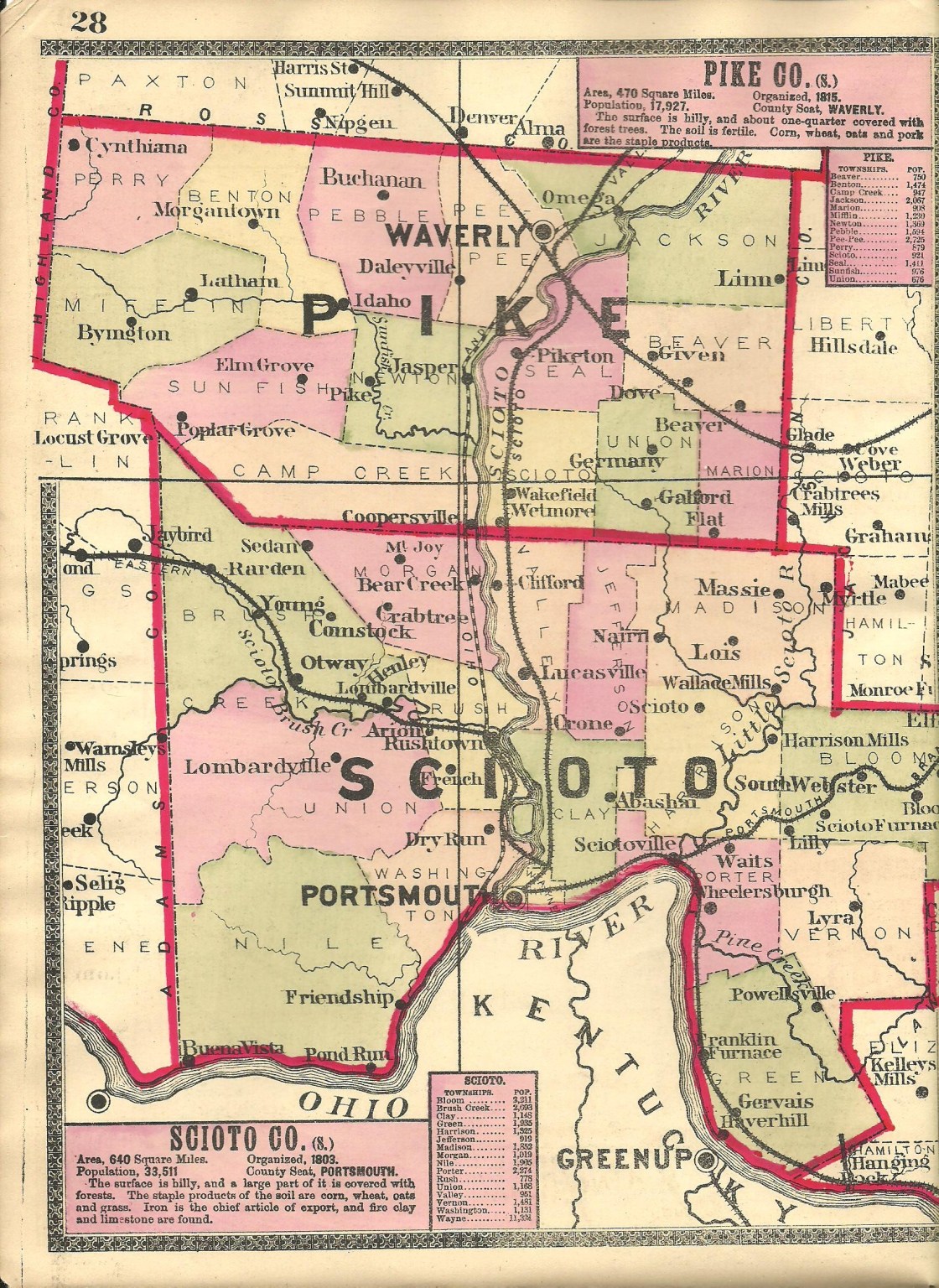
Alexanders Bridge – Sunfish Township
Location: 39.037998, -83.171777
on Laurel Ridge Rd (Co Rd 27) between SR 32 and Carters Run Rd along Carter Run
Remnants: old houses and farm buildings in the area
Description: The only literary reference to the town was found in the 1893 Acts of the State of Ohio. It was named after the Alexander family in the township and the mentioned bridge crossed Carter Run on a currently disbanded stretch of Alexander Rd (Township Rd 308). A newer bridge has since been built crossing the creek and is on private property. The earliest know members of the family in the area were John Alexander (1781 – 1851) and Catherine (Connor) Alexander (1779 – 1841). They were married in Beaver, Pennsylvania in 1806 and were buried with relatives in Rittenour Cemetery 10 1/2 miles northeast of the GPS coordinates on W 2nd Street in Piketon.
Cars Run (Carrs Run) – Jackson Township
Post Office: 1889 – 1905
Location: 39.095899, -82.866258
on Carrs Run Rd between SR 335 and Ervin Hill Rd
Remnants: Liberty Valley A. M. E. (Carrs Run) Church on the east side of Carrs Run Rd 2 miles north of the GPS coordinates, Carr’s Run Cemetery across the road from the church, stone historical marker in the cemetery, old houses and farm buildings in the area
Description: Farming and timber harvesting were the main industries in this very small town with two churches. Philadelphia Missionary Baptist Church was constructed in 1882 and is no longer active. The Liberty Valley A. M. E. congregation formed in 1888 and is still in operation with its original wood frame church and Sunday school building. A school and the post office were on the west side of Carrs Run Rd at the GPS coordinates. Peter Leist (1838 – 1924) was the postmaster. He was buried with relatives in Beaver Union Cemetery about 6 1/4 miles southeast of the GPS coordinates on the north side of Beaver Pike. The stone historical marker in Carrs Run Cemetery is very new and concerns an addition to the grounds in 2017 and its land clearance in 2018.
Galford (Gibson) – Union Township
Post Office: 1849 – 1907
Location: 38.959008, -82.892000
on Germany Rd (Co Rd 66) at the intersection of Kroger Rd (Township Rd 651) along Rocky Fork
Remnants: Slavens (Ruckman) Cemetery in the northeast lot of the intersection, Owl Creek Cemetery 1 1/2 miles northwest of the GPS coordinates on Owl Creek Cemetery Rd
Description: The town was founded by War of 1812 veteran William James Galford (1785 – 1824) and Jane (Woodell) Galford (1791 – 1870) from Augusta County, Virginia along with members of the Slavens and Ruckman families. William’s father, John Thomas Galford (1757 – 1818), was a Revolutionary War veteran. William and Jane got married in Bath County, Virginia in 1808, moved to Pike County in 1817, and had several children. The post office was originally called Gibson with Abishai Ruckman as the first known postmaster. He was succeeded by Clinton Peters. Henry Slavens Galford (1811 – 1894) married Martha (Anderson) Galford (1815 – 1892) in 1832. They inherited the family farm, which eventually expanded to 214 acres, and had 8 children. Aside from farming, Henry was also a justice of the peace for 12 years and the town’s postmaster for about 30 years from the mid-1860s until his death. The name of the post office changed from Gibson to Galford in 1880. Henry’s paternal grandmother, Naomi, was a member of the Slaven family. She was buried with John and many other relatives in Slaven Family Burial Grounds in Highland County, Virginia. As with many ghost towns in Ohio founded by war veterans, descendants of both families moved to the state and settled close to each other. The Galfords were laid to rest in Owl Creek Cemetery. The other known postmasters were Civil War veteran Reuben Slavens (1832 – 1899) who was buried with relatives in Slavens (Ruckman) Cemetery, and Milton J. Bailey (1850 – 1927) who was also buried with relatives in Owl Creek Cemetery.
Pee Pee (PP Settlement) – Pebble Township
Post Office: 1869 – 1883
Location: 39.179110, -83.120964
on Nipgen Rd along Brushy Fork between Carl Penn Rd and Turkey Run Rd (Township Rd 403)
Remnants: Eden Baptist Church and historical marker on the north side of the GPS coordinates, Eden (Cousins) Cemetery on the north side of Nipgen Rd about 1 mile east of the GPS coordinates
Description: It was named after nearby Pee Pee Creek. Peter Patrick, an early settler in what later become Pike County, carved his initials into one or more trees in the 1780s before moving back to Virginia due to attacks from local Native Americans. Free black Americans from Virginia arrived at the location in the early 1820s. Some of them were former slaves of 3rd U.S. President Thomas Jefferson and their descendants. The church congregation formed in 1824. Its first structure, a log building, was constructed that year at Eden Cemetery on land donated by Minor Muntz. A school and town hall were subsequently built to accommodate the citizens. Runaway slaves were assisted by the residents during the mid-1800s and the Civil War. James Earl (born c. 1841) was the only know postmaster. Pee Pee lost much of its population by 1900 and was totally abandoned around 1950 for economic reasons. The town’s only known cartographic appearance was on page 57 of the 1872 Topographical Atlas of Ohio.
Prussia – Pee Pee Township
Location: 39.166212, -83.000018
on Prussia Rd at the intersection of Pennington Rd
Remnants: Old German (Old Prussia) Cemetery on the east side of Prussia Rd 1/4 of a mile north of the GPS coordinates
Description: The town was founded in the mid-1800s by immigrants from Prussia, a disbanded kingdom in Germany. They formed an Evangelical Lutheran congregation in 1845. Its original log church at the cemetery was replaced by a brick structure in 1858 which has since been lost to time. The land for the church and cemetery was purchased from Anna Marie Lorbach (1820 – 1890) at a cost of $25. She was buried with relatives 4 1/3 miles south of the GPS coordinates in Evergreen Union Cemetery on SR 220 (Bridge St) in Waverly.
Robbins (Dove) – Beaver Township
Post Office: 1874 – 1934
Location: 39.038130, -82.878129
on Red Hollow Rd (Co Rd 76) at the former railroad track crossing between Beaver Pike and Coal Dock Rd
Remnants: old houses and farm buildings in the area
Description: It was named after Thomas Robbins (1833 – 1883) and Margaret (Dickason) Robbins (1836 – 1922) who donated land the track bed of the Ohio Southern Railroad (later the Detroit, Toledo, & Ironton Railroad). The post office was called Dove. Thomas and Margaret were buried with relatives and other residents in Beaver Chapel Cemetery about 1/2 of a mile south of the GPS coordinates at the intersection of Red Hollow Rd and Coal Dock Rd (Co Rd 75). The known postmasters were William Kirkpatrick, J. Motz, and Herman Shy Sr.
Shyville – Scioto Township
Post Office: 1888 – 1935
Location: 39.013042, -82.982169
on Dutch Run Rd at the intersection of McCorkle Rd along Little Beaver Creek
Remnants: none known
Description: Shyville was founded by Henry George Shy (1832 – 1910) and Clara (Knaper) Shy (1833 – 1912) when they bought a farm near the GPS coordinates in 1861 and had 12 children. They were both born in Germany and met in Germany in Jackson County about 5 miles east of their farm while Clara was visiting with some relatives. Henry was a farmer and a cabinet maker. Shyville was never a large town but had a general store, church, school, and the post office. The general store was owned by Herman Shy Sr. (1866 – 1945), a son of Henry and Clara, and Mary Margaret (Slavens) Shy (1870 – 1966). Mary was a daughter of Civil War veteran Reuben Slavens (1832 – 1899) and Harriett (Rader) Slavens (1844 – 1906) from Galford (Gibson). They got married in 1890 and had at least 6 children. Herman was the postmaster at Robbins (Dove) for 40 years. His brother Frederick B. Shy (1855 – 1935) was the postmaster at Shyville. Frederick married Josephine (Myers) Shy (1866 – 1922) from Lawrence County in 1884. They also had at least 6 children. The general store was lost in a fire and there wasn’t a lot left of the town when the U.S. Atomic Energy Program began construction of a plant there in the early 1950s. Shyville was reportedly abandoned by 1952. However, it’s still considered a populated place for census purposes. The atomic plant produced weapons grade uranium for the Cold War arms race and is currently on shutdown status. The Shy family was buried in Mound Cemetery 5 1/2 miles northwest of the GPS coordinates on Mound Cemetery Rd in Piketon.
Beaver (Beavertown) (Reynolds) (Reynoldstown) – (1840 – present farming and railroad town)
Classification: small town
Location: Beaver Township, Pike County – On Beaver Pike at the intersection of SR 335
Many of the county’s early records have been lost to time. To dispel some possible confusion for researchers in the future, the current town of Beaver was originally named Reynolds or Reynoldstown and was founded in 1840 by a man of that surname. It later changed to Beavertown, which was also the name of its train station on the Ohio Southern Railroad. The first station was built in 1899 and was destroyed in a train derailment in 1914. Another station was built to replace it and was on the Dayton, Toledo, & Ironton railroad which bought out the Ohio Southern Railroad. Most of the town’s residents were buried in Beaver Union Cemetery on the west side of town on the north side of Beaver Pike. Some other residents were laid to rest in Beaver Chapel Cemetery at the intersection of Red Hollow Rd and Coal Dock Rd about 3 1/2 miles west of town. Beaver also has a few old houses and former business buildings along Main St. There’s more information about its early days in the 1883 History of Lower Scioto Valley, Ohio.
Pike County, Ohio Ghost Towns Research Resources
1910 – Pike County map
1912 – Pike County map
-
http://www.historicmapworks.com/Map/US/1606616/Pike+County/Ohio+State+1915+Archeological+Atlas/Ohio/
