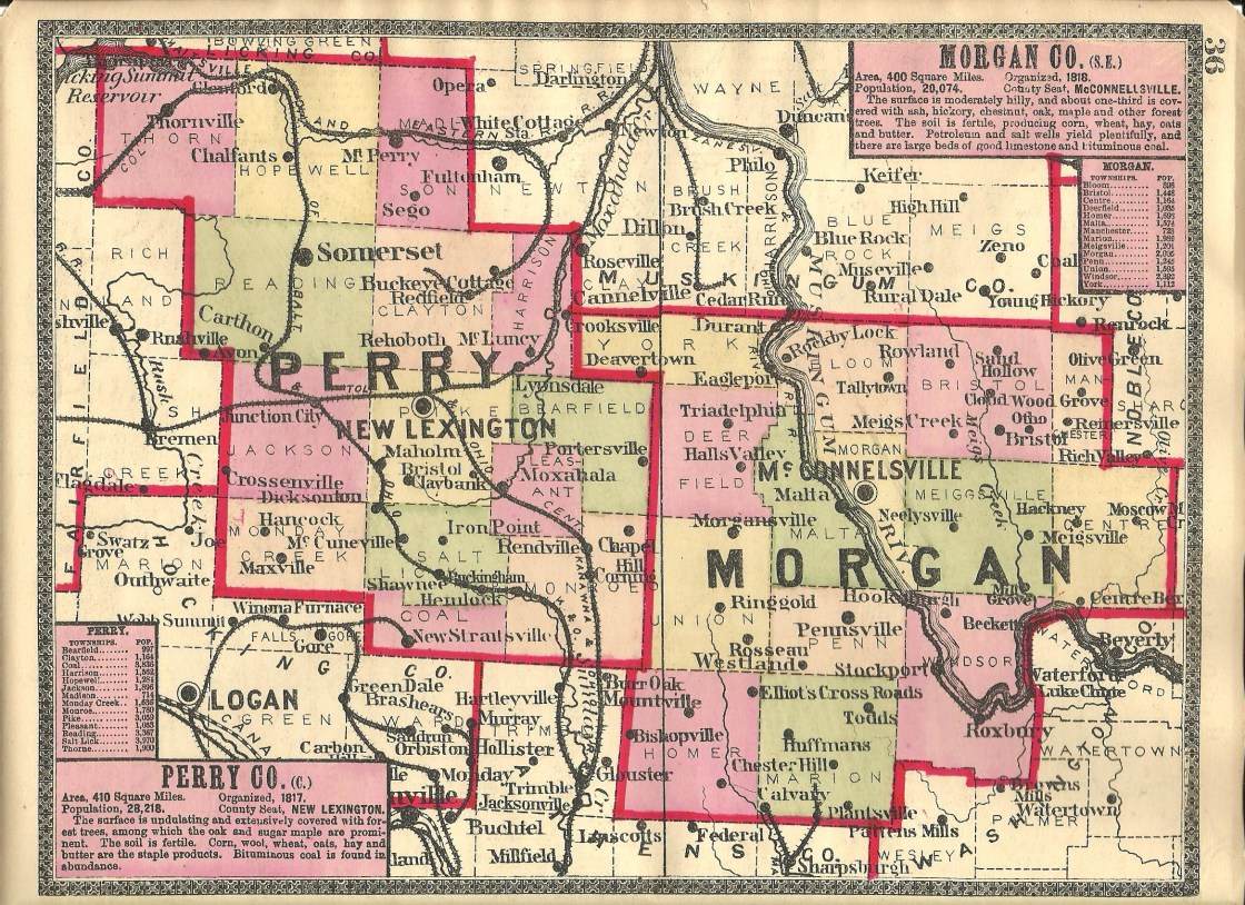
Asbury (Mount Hope) – Jackson Township
Post Office: 1832 – 1864
Location: 39.682764, -82.292995
on SR 668 at the intersection of Marietta Rd
Remnants: none known
Description: The post office was called Asbury and the town was platted as Mount Hope in 1835 by George Kishler (1799 – 1881) from Mifflin County, Pennsylvania and Irish immigrant Patrick Sweeney (1776 – 1869). George was also the postmaster. Mount Hope had a general store and a couple of other small shops but didn’t attract many residents and never grew much. Although the town was last spotted on the 1859 county map and didn’t make it into the 1875 county atlas, it was stated in the 1902 county history book that local residents still called the community Mount Hope. George Kishler was married 3 times and had several children. He was buried with relatives in New Lexington Cemetery about 6 1/2 miles northeast of town on Cemetery Rd on the southwest side of New Lexington. Patrick Sweeney was buried with relatives 2 miles north of the GPS coordinates in St. Patrick’s Cemetery on the east side of SR 668.
Beanville
Location: unknown
Description: Beanville was mentioned in the 1902 county history book as an early settlement that was never platted.
Buchanan (Sunday Creek Cross Roads) – Monroe Township
Post Office: 1839 – 1873
Location: 39.593025, -82.120925
on SR 155 at the intersection of Scenic Rd along West Branch Sunday Creek
Remnants: Monroe (Drakes) Cemetery on the northwest side of Town Hwy 309 (Township Rd 309) about 1/4 of a mile north of the GPS coordinates
Description: It was the first settlement in Monroe Township. The original proprietors were county pioneers John McDonald Sr. (1786 – 1861) and Sarah (Dew) McDonald (1795 – 1872). They made the journey to Ohio from Maryland in 1814 with Sarah’s brother James Dew (1787 – 1875) who settled in the southeast portion of the township. The post office was originally called Sunday Creek Cross Roads. It changed to Buchanan in 1856. John was the first postmaster and N. H. Bentley was the last known postmaster. John McDonald Jr. (1829 – 1881) inherited much of the family land and operated a saw mill northwest of the GPS coordinates on the west side of Scenic Rd SE. Morgan’s Raiders, a Civil War Confederate Army cavalry unit, rode through Sunday Creek Cross Roads in 1863 and didn’t do any harm there. However, nearby Millertown wasn’t as lucky, suffering great losses in stolen goods and damage. After making it through the harsh decades of early 1800s pioneer life and having much success with farming and their land speculation, John and Sarah McDonald became the wealthiest residents in the township and possibly the county. They had at least 8 children, all born in Ohio, and were buried with relatives in Monroe Cemetery. John McDonald Jr. was buried with relatives in New Lexington Cemetery. Sunday Creek Cross Roads faded into oblivion shortly after the town lost its post office and Buckingham was platted just to the west that same year.
Claybank (Clay Bank) – Pike Township
Post Office: 1882 – 1906
Location: 39.675360, -82.183317
on Township Hwy 218 SE at the railroad crossing between Township Hwy 219 SE and Marietta Rd SE
Remnants: none known
Description: It was a mining town on the Toledo & Ohio Central Railroad. One of the coal mines north of the GPS coordinates was on land owned by Abraham Park (1814 – 1908) and Mary (Lee) Park (1817 – 1893). They moved to Ohio from New Jersey. A son on theirs, Civil War Veteran Thomas Park (1843 – 1902) and his wife Louanna (Jordan) Park (1852 – 1933), owned another mine north of it. Edward Hillis (1831 – 1915) and Alice (Ferguson ) Hillis (1834 – 1889) owned a mine on the east side of the GPS coordinates. Thomas Kinsel Jr. (1865 – 1944) was the last postmaster. Everyone mentioned in this listing was buried with relatives in New Lexington Cemetery.
Coaldale (Coal Dale) – Salt Lick Township
Post Office: 1869 – 1872
Location: unknown
Description: none found
Dew Creek – Monroe Township
Post Office: 1858 – 1860
Location: 39.555392, -82.064469
on Cornstill Rd SE at the intersection of Irish Ridge Rd SE
Remnants: Dew Cemetery on the west side of Irish Ridge Rd SE about 1/4 of a mile north of the GPS coordinates
Description: As the McDonalds were growing to be the most prominent family in the township at Sunday Creek Crossroads, James C. Dew Sr. (1785 – 1875) from Maryland and Lydia (Tuttle) Dew (1800 – 1879) weren’t far behind in stature. They had a large family of at least 11 children and were also successful in farming and land speculation. Although the post office didn’t last long, the town and Dew family were very influential in the area. In the mid-1800s, there was a school 1 mile north of the GPS coordinates on the east side of Irish Ridge Rd SE at Spencer Ridge. A newer school was built around 1870 and was on the west side of Irish Ridge Rd in the southwest corner of the intersection of Town Hwy 298 SE (Township Rd 298 SE). Eli Dew (1840 – 1915) and Sarah (Dorris) Dew (1845 – 1917) got married in 1864 and had several children. They owned a grocery store on the east side of Irish Ridge Rd SE just north of Spencer Ridge. The Atlantic & Lake Erie Railroad was built through the area in the early 1870s. James and Lydia donated land for its track path, but it didn’t revitalize Dew Creek which had been declining for several years as other towns around the county and across the borders in Athens and Morgan County were booming with coal production. Everyone mentioned in this listing was buried in Dew Cemetery. It dates back to the 1810s with James and Sarah (Dew) McDonald’s parents, Thomas Dew (1750 – 1818) and Josinah (Crabtree) Dew (1759 – 1816), being a couple of the earliest known interments. The cemetery was officially established in 1869 and is nicely maintained. Over 120 Dew family members have been laid to rest there.
Dicksonton (Dickson City) – Pike and Salt Lick Township
Post Office: 1875 – 1876 and 1880 – 1908
Location: 39.648806, -82.249462
on Town Hwy 224 (Township Rd 224 SE) between SR 93 and Town Hwy 226
Remnants: none known
Description: Dicksonton was platted in 1875 by George Detwiler and Revered William H. Price (1838 – 1909). It was originally called Dickson City, along with the post office, and was a coal and iron mining town on the Newark, Somerset, & Straitsville Railroad (later the B&O). The town had around 100 residents and a general store. Although the post office remained in operation for a few years longer, the village was said to be deserted in the 1902 county history book. William Price was buried with relatives about 8 1/2 miles northwest of town in New Lebanon Evangelical Lutheran Burial Ground on the west side of Old Junction Rd N (Co Rd 94). The area is currently called Dixie.
Dogtown
Location: unknown
Description: As with Beanville, Dogtown was mentioned in the 1902 county history book as an early settlement that was never platted.
Gordon Cross Roads – Jackson and Pike Township
Location: 39.676264, -82.254692
on Marietta Rd E at the intersection of Dutch Ridge Rd
Remnants: none known
Description: The original proprietors were William Gordon (1772 – 1849) from Frederick County, Maryland and Mary (Cain) Gordon (1778 – 1867) from Monongalia County, Pennsylvania. William was a farmer and became a well-respected judge. He was married 3 times, with Mary Cain being his last wife, and most of his children stayed in West Virginia where William lived for a few years before moving to Ohio. William and Mary were buried with relatives in Holy Trinity Cemetery about 12 miles north of town on S Columbus St in Somerset.
Hamburg – Monroe Township
Location: 39.583419, -82.103152
on Town Hwy 283 along West Branch Sunday Creek between SR 155 and Scenic Rd
Remnants: none known
Description: Hamburg was a coal mining town on the Zanesville & Western Railroad. The land was formerly owned by the John and Sarah McDonald. One of their sons, Lewis McDonald (1819 – 1870), inherited the land and was the last owner before the mining industry arrived. He was buried with relatives in Monroe Cemetery.
Hancock – Monday Creek and Jackson Township
Post Office: 1877 – 1902
Location: unknown
Description: Lewis A. Gillespie (b. 1853) was the first postmaster. Isaac E. Ashbaugh (1859 – 1940) was the last known postmaster and general store owner. He was buried with relatives in Bethel Church Cemetery at the intersection of SR 668 and Town Hwy 372 (Township Rd 372).
Hanover – Reading Township
Location: unknown
Description: Hanover was platted in 1804 by Jacob Dittoe Sr. (1759 – 1826) and Catherine (Sneeringer) Dittoe (1764 – 1853). It was originally in Fairfield County and was approximately 4 miles west of Somerset. The town was unsuccessful in attracting residents and industry. During the first session of the Perry County Court Of Common Pleas in July of 1818, Jacob applied to have the plat vacated and his request was subsequently granted. The Dittoe family, along with 5 other local families, built the first Catholic church in the state which later became St. Joseph Church. It was an 18 x 22 feet log cabin. They donated the 320 acres of land it was on to Bishop Edward Fenwick. Jacob and Catherine were buried with relatives and other early pioneers in Old Saint Josephs Priory Cemetery about 2 1/2 miles southeast of Somerset on the west side of SR 383. The current church structure was completed in 1866. There’s also a historical marker along the roadside with more info.
Hansleys Cross Roads (Hansley’s X Roads) – Bearfield Township
Post Office: 1836 – 1849
Location: unknown
Description: The proprietor and postmaster was John Hansley (1774 – 1849). The office was discontinued when he passed away. John was buried in Holcomb (Fletcher Chapel Methodist Episcopal) Cemetery on the west side of Town Hwy 202 (Township Rd 202) between Township Hwy 201 and Royma Rd NE (Co Rd 66).
Hoboken – Monroe Township
Location: 39.558820, -82.103376
on Scenic Rd at the intersection of Cornstill Rd SE along West Branch Sunday Creek
Remnants: abandoned farm buildings on the west side of Scenic Rd south of the GPS coordinates
Description: It was a coal mining town on the Zanesville & Western Railroad. The mines were operated by the Atlantic & Lake Erie Coal Company. Many residents, including the Maxwell family who formerly owned the land where the GPS coordinates are, were buried in Beech Grove Church (Conn) Cemetery on Town Hwy 435 (Township Rd 281) west of town on the other side of Indian Run.
Horne – Harrison Township
Location: 39.759228, -82.094827
on SR 93 along the railroad tracks and Moxahala Creek between Snake Hollow Rd and School Dr on the south side of Crooksville
Remnants: none known
Description: Horne had a passenger station on the Cleveland, Akron, & Columbus Railroad in the early to mid-1900s. The town was listed on the Harrison Township map in the 1941 county atlas. The railroad’s last run was from Cleveland to Columbus in December of 1950.
Lyonsdale – Harrison Township
Post Office: 1883 – 1906
Location: 39.732768, -82.137289
on Tunnel Hill Rd (Co Rd 6) along the railroad tracks between Township Rd 208 NE and Pole Cat Rd (Co Rd 48)
Remnants: none known
Description: It was another stop on the Cleveland, Akron, & Columbus Railroad and had mines operated by the Tunnel Hill Coal Company. Michael Meenan (1842 – 1924) was the town’s postmaster. He was buried with relatives in New Lexington Cemetery.
Middletown – Jackson Township
Post Office: dates not listed
Location: 39.659077, -82.316813
on SR 668 at the intersection of Town Hwy 335
Remnants: Friendship Methodist Episcopal Church and Cemetery north of the GPS coordinates on the east side of SR 668
Description: The town was platted in 1853 and had a train tunnel named after it on the Scioto & Hocking Valley Railroad. The tunnel was constructed in 1853 – 1854 and crossed the township border just south of the GPS coordinates. Middletown had a post office, 2 stores, and about 50 residents. It’s unknown what the post office was called, but it couldn’t be Middletown because there was already one by that name in Butler County. Friendship Methodist Episcopal Church was constructed around 1870. Many of the town’s residents were buried in the cemetery. Middletown was mentioned in the 1902 county history book and fell into obscurity shortly after that.
Nugentville
Location: unknown
Description: It was on the Cleveland & Mahoning Valley Railroad and had mines owned by the Imperial Coal Company which built some houses for the workers in the first decade of the 1900s.
Oconorville – Pleasant Township
Location: 39.660029, -82.160141
on Biddison St SE (Township Hwy 395) along Moxahala Creek between SR 13 and Town Hwy 324
Remnants: none known
Description: The town was founded by Irish immigrant John O’Conner (1798 – 1854). It’s unknown if Oconorville was ever platted or if any attempt to create a village actually happened. After John passed away, the area continued to go by Oconorville for several decades. The last known mentioned it received was the recording of its elevation in a 1911 book, Results Of Spirit Leveling In Ohio. John was buried in St. Patricks Cemetery south of Junction City on the east side of SR 668.
Opera – Madison Township, Perry County and Hopewell and Newton Township, Muskingum County
Post Office: 1881 – 1901
Location: 39.909847, -82.169810
on Township Hwy 108 at the intersection of Asbury Chapel Rd along Kent Run
Remnants: Jack’s Hollow (Dolling’s) Covered Bridge on Township Hwy 108 about 1/4 of a mile south of the GPS coordinates, old houses and farm buildings in the area
Description: Opera was a small farming and postal town. Louisa E. Dollings (1845 – 1925) was the first postmaster when the office was in Muskingum County. She was buried with relatives in Asbury Chapel Cemetery 1 1/2 miles north of the GPS coordinates at the intersection of S Hopewell Dr and Asbury Chapel Rd. The post office moved to Perry County and Charles W. Stine (1853 – 1914) was the last known postmaster. He was buried with relatives in Wesley Union Cemetery about 5 miles southeast of the GPS coordinates on the west side of Wesley Chapel Rd. Jack’s Hollow Covered Bridge, also known as Dolling’s Covered Bridge, was completed in 1879 and has since been restored.
Tatmans – Bearfield and Pleasant Township
Location: 39.668033, -82.082256
on Tatmans Rd SE (Co Rd 22) at the intersection of Portie – Flamingo Rd (Co Rd 12)
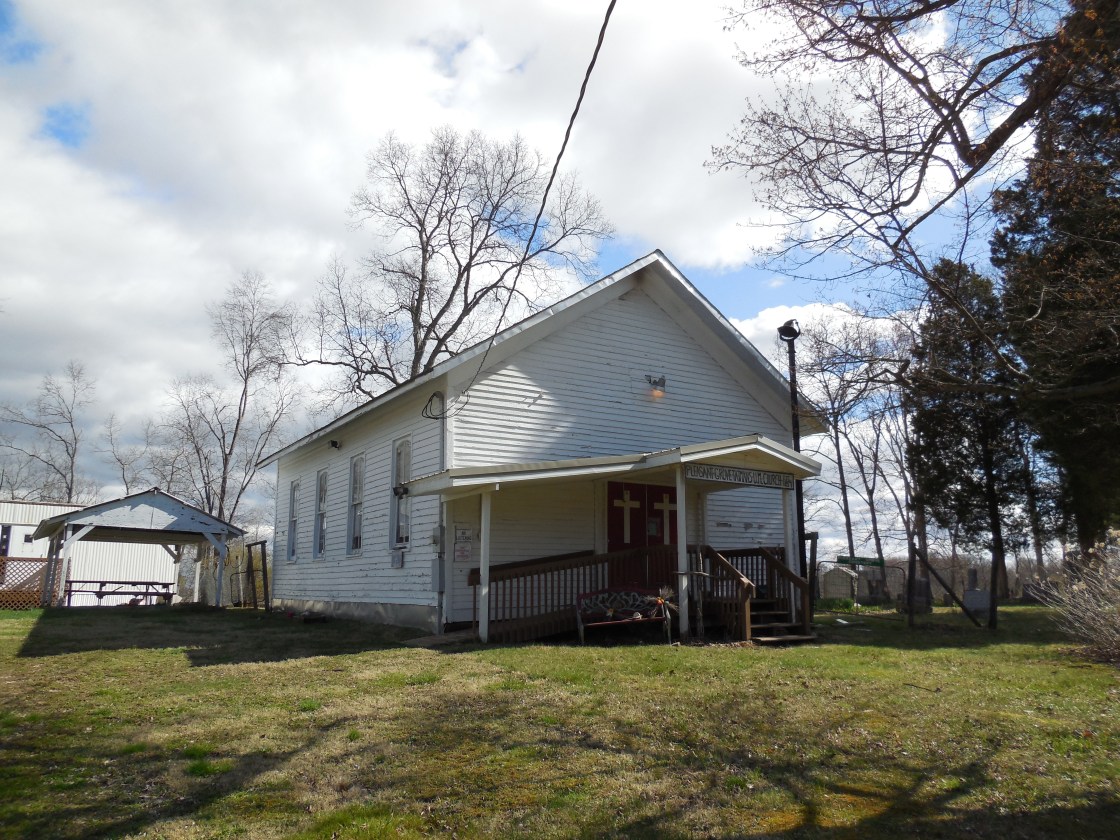
Remnants: Pleasant Grove (Tatmans) United Methodist Church and Pleasant Grove (Tatman) Cemetery on Portie – Flamingo Rd about 1/4 of a mile northwest of the GPS coordinates
Description: The proprietors were Bartholomew Tatman (born c. 1794) and his wife, likely either named Anny or Amy. They moved to Ohio from Allegheny County, Maryland in the late 1810s along with Bartholomew’s parents and his 6 younger siblings. Pleasant Grove (Tatman) Church congregation was organized in the mid-1830s with meetings originally held in the Tatman farmhouse. The congregation built a log church and replaced it with the present wood frame structure which was constructed in 1859 – 1861. The Tatman family headed west to Washington County, Iowa in 1843, but moved back to Perry County a few years later. Bartholomew was last recorded living in Fairfield County with his son Joshua Tatman (1832 – 1871) in the 1860 census. Genealogy records on the family are scare. It’s unknown where Bartholomew and his wife were buried. However, Joshua served in the Civil War and ended up back in Washington County, Iowa where he was laid to rest with relatives in Riverside Cemetery on Tulip Ave in Riverside.
Wellan – Reading Township
Location: 39.776456, -82.311817
on Town Hwy 143 (Township Rd 143 NE) along Somerset Creek at the former railroad track bed west of SR 668
Remnants: none known
Description: It was founded in the 1870s by German immigrant George Wellan (1824 – 1893) and Irish immigrant Mary Wellan (born c. 1822) as a mining town on the Newark, Somerset, & Straitsville Railroad (later the B&O). The town was last spotted on the Reading Township map in the 1941 county atlas. It’s unknown where George and Mary were buried. Their surname also had several alternative spellings on genealogical records such as Wellen and Wellon, and sometimes there was an “s” attached to the end.
Worth – Bearfield Township
Post Office: 1848 – 1866
Location: 39.715856, -82.115383
on SR 93 at the intersection of Town Hwy 402 (Township Rd 402) along Moxahala Creek
Remnants: none known
Description: This small farming town had a general store and a church. William C. Moore (1808 – 1882) was the first postmaster. His brother John S. Moore (1805 – 1879) was the last postmaster. Another one of their brothers, James H. Moore (1809 – 1897), revolutionized the lumber industry with his invention of the portable steam-powered saw mill. They were produced in mass quantities in Zanesville and shipped worldwide.
Chapel Hill (Thompsonville) – (1849 – present farming and merchant town with less residents than in the past)
Classification: semi-ghost town
Location: Monroe Township, Perry County – On Irish Ridge Rd SE between Chapel Hill Rd SE and Town Hwy 455
Chapel Hill was originally called Thompsonville and was platted in 1849 by Irish immigrant George Thompson (1812 – 1880) and Sarah Thompson (1807 – 1882) and Bryan Murtaugh. It was an Irish community and had a Catholic church, a hotel, school, general store, and a few other merchant shops. The population was 52 residents in 1880. Chapel Hill never attracted a railroad and or large industries. As a result, it didn’t have any population booms and the number of citizens gradually declined over the 1900s. Over 300 local residents were buried in Chapel Hill (Saint Francis Catholic) Cemetery. It was officially established in 1840. George and Sarah were buried with relatives in Bailey Cemetery on the south side of S Bailey Ridge Rd near the Muskingum River north of Stockport in Morgan County.
Congo, OH – (1891 – present coal mining and railroad town slowly abandoned over time)
Classification: semi-ghost town
Location: Monroe Township, Perry County – On Scenic Rd SE (County Rd 68)
Congo hit the maps when coal mining started in the area and 40 houses were built for the employees. The ownership and management of the mines changed several times over the decades, which seemed to keep the town from moving forward and growing at times. It never had a big population and has been getting smaller since the mines shut down in 1954. Congo had a post office from 1892 – 1959. There are some abandoned buildings, old foundations, and smaller remnants in the area.
Hatfield, OH (Hatfield’s Crossing) – (early 1800s – present mill and coal town partially destroyed by floods)
Classification: small town
Location: Monroe Township, Perry County – On SR 13 at the intersection of Township Hwy 295 along Sunday Creek
The town was named after John Hatfield (1818 – 1920) from Somerset County, Pennsylvania and Alice (Darnell) Hatfield (1821 – 1897) from Culpeper County, Virginia. They owned a mill along Sunday Creek near the intersection and had 9 children. Town Hwy 295 (Township Hwy 295), along with a few others in the area off of SR 13, was an old stagecoach road. Hatfield became a transportation hub with crossroads going in all directions. The Atlantic & Lake Erie Railroad (later the Zanesville & Western Railroad) arrived in the area in the early 1870s. Its parent coal company extracted ore from local beds. Hatfield’s mill was pinpointed in section 26 of the Monroe Township map in the 1875 county atlas. It was originally a steam-powered saw mill and was converted to a grist mill in the mid-1880s. The town was hit hard by a flood in 1903. Some residents stayed, but most left after subsequent floods in the early 1900s. Stones from the mill foundation made of cut sandstone could be found in Sunday Creek up until 1966 when SR 13 was rebuilt. John and Alice Hatfield were buried with relatives and other early residents from the area in Dew Cemetery on Irish Ridge Rd about 2 miles south of the intersection. We previously had Hatfield incorrectly listed as a ghost town, but it’s still a currently populated place and a minor civil division in Perry County. The Buckingham Coal Company also continues to operate at the location.
Thanks to Linn Keller for providing some of the info on Hatfield!
New Straitsville, OH – (1870 – present coal mining and railroad town)
Classification: historic town
Location: Coal Township, Perry County – On SR 93 at the intersection of SR 216
The town of Straitsville, which is still a populated place about a mile north of New Straitsville on County Rd 38 (Old Town Rd), was platted in 1835 by Jacob and Isaac Strait. Its first post office ran from 1848 – 1870 and another one called Sheldon ran from 1880 – 1884. The population was 308 in 1880. New Straitsville was founded in 1870 as coal production in the area began. Many of the residents of Straitsville moved south to work in various coal industry related jobs. New Straitsville had over 4,000 citizens by 1880. The town is also nicknamed the “Bootleg Capital Of Ohio” after its former moonshine producing days and holds an annual Moonshine Festival on Memorial Day weekend. A local mine fire, which was set by coal miners during a labor strike in 1884, reportedly continues to burn and smolder to this day. Robinson’s Cave is on Railroad Rd off of Main Street on the south side of town where mining labor meetings were held. The population in the 2010 census was recorded at 772.
Moonshine Festival Info – http://www.ofea.org/festivals-and events/festivals/moonshine-festival.html

Rendville, OH – (1879 – present coal mining and railroad town mostly abandoned during the Great Depression)
Classification: small town
Location: Monroe Township, Perry County – On SR 13 at the intersection of Valley St
It’s currently Ohio’s smallest town with 36 residents in the 2010 census. Rendville was established in 1879 by William P. Rend (1840 – 1915), a Civil war veteran who later moved to Chicago and turned into a railroad, coal, and oil tycoon. William built whatever his employees needed including grocery stores, saloons, and hotels. The town had around 1,000 residents at its peak in the 1880s. Rendville was hit hard by the Great Depression and has been losing residents since then. The town lost its post office in the early 1980s. Many early settlers are buried in Rendville Cemetery at the end of Main St off of SR 13.
Thanks to group member Brett Taylor, manager of Ohio Hiking Trails and Historical Sites, for providing the listing picture! Thanks also to group member Tammy Altman for providing the info on William P. Rend!
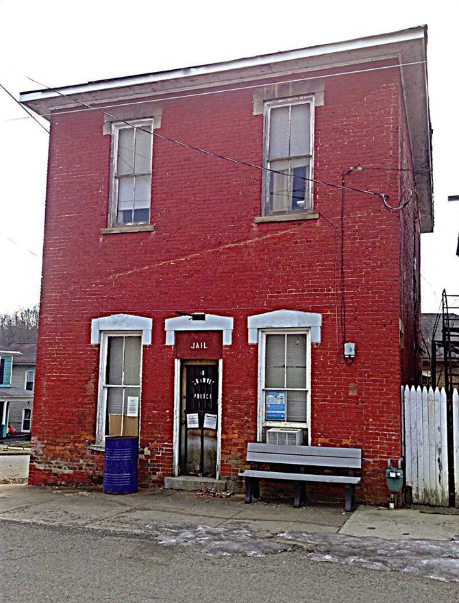
San Toy, OH (1900 – present mining town that was nearly abandoned but later repopulated)
Classification: semi-ghost town
Location: Monroe Township, Perry County – At the intersection of Santoy Rd and Town Hwy 452
The Sunday Creek Coal Company built San Toy in 1900 to house and accommodate its workers. This rough and rowdy mining town at the northern edge of Ohio’s Hanging Rock Region had a roller coaster worth of ups and downs. San Toy boomed from the very beginning and made its best attempt to maintain law and order in a densely populated community. The town’s former jail, at the southwest corner of the intersection of Santoy Road and Township Highway 452, hides out in a wooded lot these days and appears to enjoy the peace and quiet.
Across Santoy Road from the jail, a water well pump house has lost its roof but the walls are still intact. The town’s tough reputation was partly due to its large number of saloons and drinking being the biggest after work hobby. San Toy had the only hospital in the county at the time and needed it for both for the mine workers and those injured in bar brawls and street fights. It also had a theater and a baseball team for entertainment. The baseball team competed against other mining company and small town teams in the area.
In 1924 a group of disgruntled workers pushed a cart full of flaming logs down into a mine shaft during a labor dispute. The fire destroyed the mine, hospital, and theater. After the dispute was settled, mining continued until 1927 when the coal company decided it didn’t want to invest in the location anymore. Instantly losing their main industry, San Toy’s citizens didn’t have many other options and most moved away as soon as possible. A set of steps that don’t go anywhere anymore climbs into oblivion where a house used to be near the jail.
The few residents that stayed behind kept the town going with revenue from making moonshine. Between 1927 and 1930 San Toy lost more residents than any other town in the United States. In 1931, 17 of its 19 remaining citizens voted to abandon the town. There are now newer residences in the area among the remnants of the ghost town and it still goes by the name San Toy.
Shawnee, OH – (1872 – present coal mining and railroad town slowly abandoned over time)
Classification: small town
Location: Salt Lick Township, Perry County – On SR 93 at the intersection of SR 155
It was the largest town in Perry County for decades, but keeps getting smaller as more people move away. Shawnee now has just a fraction of its peak population and was at 655 residents in the 2010 census. Main Street has a lot of beautiful architecture and looks like a brick town from the late 1800s to early 1900s. For several years only a few buildings were still in operation. The majority of them were abandoned along with many other small business and homes in the area due to the mining industry leaving and competition from large chain department stores in nearby towns. However, Shawnee has since undergone a resurgence in the care for its buildings and history. The citizens are working hard to increase tourism with new events, restoring buildings, and opening more businesses.
Thanks to group member Brett Taylor, manager of Ohio Hiking Trails and Historical Sites, for providing the listing picture!
Sulphur Springs, OH – (mid-1800s – present farming and mill town with less residents than in the past)
Classification: small town
Location: Salt Lick Township, Perry County – On Sulphur Spring Rd SE at the intersection of Township Rd 215A
The town was named after a mineral spring that runs through the area and had a couple of saw mills and grist mills in the mid to late 1800s. There was also a school on the west side of Sulphur Springs Rd SE just south of the intersection and a Campbellite Church at Springer Cemetery 1 1/2 miles northeast of the intersection on the west side of Bohemian Rd SE (Co Rd 13). A general store on the north side of the intersection, which was the site of an awful explosion on September 9, 1870, was owned by Lewis McDonald (1819 – 1870) and Margaret (Wilson) McDonald.
Lewis, Civil War veteran George Gaver (1820 – 1870) who owned the Lyons Flouring Mill, and George W. Gordon were in the store at the time. George Gaver was purchasing some rock blasting powder and stated the quality wasn’t very good after looking at it. He had a bit of the powder in his hand, lit a match to it, and the powder didn’t ignite. Lewis said that form of testing the powder wan’t fair and took some out of a hole in a keg. After placing it on top of a chair several feet from the keg, Lewis struck a match, and applied it to the powder. The entire store immediately exploded, badly burning the 3 men and partially burying them in debris.
One of Lewis’s toddler sons, Nirum (or Niram) McDonald (1866 – 1870) was playing just outside the door and was instantly killed. 13 year old John Priest (1857 – 1870) was also outside and likely about to enter the store. John’s clothes caught fire, so he ran to the nearest section of the creek and jumped in. A woman who was passing by witnessed the incident and pulled John out of the water to keep him from drowning, but he only lived a few minutes longer. The 3 men in the store all made their way out. However, Lewis and George Gaver died a few hours later with Geroge W. Gordon being the only survivor of the tragedy.
Lewis, Nirum, and George Gaver were laid to rest with relatives in Monroe (Drakes) Cemetery 3 1/3 miles east of the store on Township Hwy 309 (Township Rd 309) in Monroe Township. John Priest was buried with relatives in Oakwood (Ebenezer Baptist / Millertown) Cemetery 4 1/4 miles east of the store on Town Hwy 283. Although the original town site is long gone, Sulpher Springs is classified as a small town for maintaining its existence as an unincorporated community.