
Arena – Paulding Township
Post Office: 1892 – 1902
Location: 41.135328, -84.631421
on SR 111 at the intersection of Rd 87 along Big Run
Remnants: former grange hall 2 miles southeast of the GPS coordinates at the intersection of SR 500 and Town Hwy 95 (Township Rd 95), St. Pauls Church and Cemetery 1 1/2 miles south of the GPS coordinates at the intersection of Rd 87 and Town Hwy 114, former one-room schoolhouse 1 1/4 miles south of the GPS coordinates in the southeast corner of the intersection of Rd 87 and SR 500, Cooper – Haines Cemetery 1 1/3 mile southeast of the GPS coordinates at the intersection of SR 500 and Rd 93
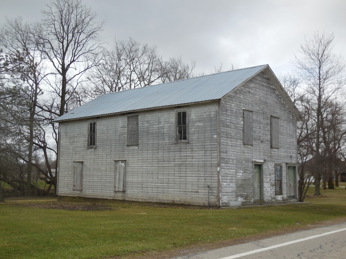
Description: Paulding Grange No. 33 was organized in 1874. Its hall was constructed in the early 1890s and first appeared in the 1892 county atlas on a 240-acre farm owned by John B. Mossoney Jr. (1826 – 1908) from Belgium and Martha (Smith) Mossoney (1836 – 1921). A general store operated on the first floor and the second floor was used for meetings. The building was donated to the John Paulding Historical Society for preservation in 2017 and is certainly one of the more impressive looking 1800s grange halls left in the state. John and Martha were buried with relatives and other residents in St. Pauls Cemetery. Its present church structure was completed in 1882 and is still in use. A couple of schools were pinpointed in the 1892 county atlas. One of them was 3/4 of a mile northeast of the GPS coordinates on the east side of Town Hwy 93 (Rd 93). The other school was on an 80-acre farm owned by the Overturf family at the current location of the only one remaining (Paulding Township No. 1), which was built in 1900 and eventually converted to a township house. It was pinpointed in the 1905 county atlas along with another lost school a mile north of the GPS coordinates in the northeast corner of the intersection of Rd 87 and Rd 144. Arena’s known postmasters were J. P Poorman, Gertie H. Musgrave, Calvin Fultz, and L. E. Babcoke. The office was replaced by an RFD (Rural Free Delivery) route. Civil War veteran John Cooper (1838 – 1888) from Marion County and Catherine (Reidel) Cooper (1842 – 1923) from Germany got married in 1865 and moved to Paulding County in 1873. They owned an 80-acre farm, had 3 children, and donated the land for the western half of Cooper – Haines Cemetery where they were buried with relatives and other residents. John died of typhoid the week after his daughter, Emma Caroline Cooper (1872 – 1888), perished of the same illness. The eastern half of Cooper – Haines Cemetery was donated from an 80-acre farm owned by Augustus E. Haines (1831 – 1915) from Logan County and Emeline (Crowder) Haines (1829 – 1912) from Belmont County. They got married in 1852, had at least 2 children, and were also laid to rest with relatives in the cemetery.
Carryall – Caryall Township
Post Office: 1863 – 1874
Location: 41.237246, -84.755065
on SR 49 at the 4-way intersection of Co Hwy 230 and Johnson Rd (Rd 230)
Remnants: Clark Cemetery on private property about 1/3 of a mile northeast of the GPS coordinates on the east side of SR 49 just south of North Branch Marie DeLarme Creek
Description: Josiah McCormick (1829 – 1916) was the proprietor and postmaster. He married Harriet (Cooper) McCormick (1834 – 1859) from Hancock County in 1851 and owned a 182-acre farm on the south side of the GPS coordinates. Harriet was laid to rest with a son, William F. McCormick (1854 – 1857), a later infant son of Josiah, and other residents in Clark Cemetery. The cemetery was established on a 148-acre farm owned by Joseph Clark (1817 – 1873) from Pennsylvania and Nancy E. Clark (1820 – 1905) from Vermont. After Harriet passed away, Josiah married Percy (Munger) McCormick (1839 – 1915). They had at least 4 children and were buried with relatives in Forest Home Cemetery 5 miles north of the GPS coordinates on SR 18 (N Main St) in Hicksville, Defiance County.
Cranesville – Crane Township
Post Office: 1829 – 1865
Location: 41.237592, -84.618010
on Rd 192 (T-192) along the Maumee River between Rd 89 and Rd 105 (Co Hwy C-105)
Remnants: Horatio Nelson Curtis House on private property about 1/2 of a mile south of the GPS coordinates
Description: The town was founded by General Horatio Nelson Curtis (1803 – 1874) from New York. He named it after Oliver Crane who was another early settler and also had the township named after him. Horatio was the first county clerk and recorder, a surveyor, Freemason, and a justice of the peace. He built a nice brick house and trading post near the north bank of the Maumee River in 1825. It’s likely the oldest existing structure in the county. A wood addition to the house was built in 1826. The addition was reportedly haunted by former residents and has since been demolished. Cranesville’s known postmasters were Abraham Davis, N. L. Thomas, N. G. Sales, Ephraim Burwell, and Hortaio N. Curtis. A school was on land donated by Horatio about 3/4 of a mile northwest of the GPS coordinates in the northwest corner of the intersection of Rd 192 & Rd 89. Horatio also platted Antwerp in Caryall Township 1841 and was buried there with relatives in Riverside (Village) Cemetery on Island St. According to census records from 1840 – 1870, he was married to a Susan Curtis (born c. 1812) from Pennsylvania and had at least 3 children. The term “General” applied to Horatio’s name appears to have been an honorary title and of no military relevance.
Doylestown – Washington Township
Post Office: 1851 – 1851
Location: 41.026894, -84.361366
on the west side of SR 66 along the former Miami & Erie Canal path between Rd 48 (T-48) and SR 114
Remnants: none known
Description: It was between Hamer and Timberville on the Miami & Erie Canal and had the first post office in the township. The proprietor was canal boat captain Samuel Doyle Sr. who transported mail from Cincinnati to Toledo on packet boats and owned a 240-acre farm on the west side of the GPS coordinates. Doylestown wasn’t pinpointed on the 1878 county map as the tiny village had dissipated by then. The canal path can still be seen on satellite maps.
Ettiesburg (Etties-Burg) – Brown Township
Location: 41.094030, -84.361279
on Rd 209 (Co Rd 209) at the railroad crossing between Rd 104 (T-104) and SR 613
Remnants: Prairie Chapel and Cemetery about 1/2 of a mile north of the GPS coordinates at the intersection of Rd 209 and Rd 104 (T-104)
Description: Ettiesburg was platted in 1860 by War of 1812 veteran Samuel Shisler (1793 – 1870) from Orange County, Virginia and Mary (Bollinger) Shisler (1794 – 1874) from Maryland. They got married in 1816, had at least 7 children, and named the town after their daughter Arettie. A school was just south of the GPS coordinates in the southeast corner of the intersection of SR 613 and Rd 209 in the late 1800s to early 1900s. Ettiesburg couldn’t keep up with nearby Oakwood though, which grew much faster and had a train station on the New York, Chicago, & St. Louis Railroad (Nickel Plate Road). The Shislers were buried with relatives and other residents in Prairie Chapel Cemetery.
Flat Rock Settlement (Flat Rock City) – Harrison Township
Location: 41.088778, -84.702040
on SR 613 along Flatrock Creek between Town Hwy 51 and Township Rd 59
Remnants: none known
Description: The original proprietors were War of 1812 veteran Thomas Wentworth (1791 – 1880) and Rachel (Townsend) Wentworth (1791 – 1858) from York County, Maine. They got married in 1814, had at least 8 children, and were the first settlers in the township in 1837. Thomas served as a justice of the peace, judge, and county commissioner. After more families moved to the area, it became known as Flat Rock City. The settlement was never platted and faded into obscurity in the mid-1800s. Thomas and Rachel were buried with relatives and other early pioneers of the county in Clark Cemetery on private property on the east side of SR 49 in Caryall Township.
Follmer (Folmer) (Fulmer) – Blue Creek Township
Post Office: 1882 – 1896
Location: 41.033653, -84.582553
on Rd 48 (T-48) between McDonald Park (Co Rd 107) and US 127
Remnants: none known
Description: The town was on the Cincinnati, Jackson, & Mackinaw Railroad (later the Cincinnati Northern Railroad). It was founded by German immigrant Andrew Fulmer (born c. 1827) and Sarah L. Fulmer (born c. 1830) from Pennsylvania. They owned an 80-acre farm on the northwest side of the GPS coordinates, had at least 4 children, and were last recorded in Paulding County in the 1880 census. Andrew still owned the farm when the 1892 county atlas was published. A school called McDonald was 1/2 of a mile west of the GPS coordinates in the northeast corner of the intersection of Rd 48 and McDonald Park. The known postmasters were S. G. Bowyer and L. A. Fast.
Gilberts Mills – Latty Township
Post Office: 1871 – 1889
Location: 40.997353, -84.476466
on SR 637 at the intersection of Rd 18 (T-18) along Maddox Creek
Remnants: Middle Creek Church & Cemetery 1 3/4 miles northeast of the GPS coordinates on the Rd 24 (C-24) between Rd 151 and Middle Creek
Description: The proprietor was Philander Gilbert (1813 – 1887) from Livingston County, New York who moved to Ohio in 1832. He originally resided in Licking County and operated a grist mill and saw mill with his uncle, David Hawley, until 1861. Philander then moved to Franklin County and purchased a steam-powered saw mill. He relocated to Paulding County in 1865 and reconstructed the saw mill on an 80-acre farm in the northwest corner of the intersection. The mill was destroyed by a fire in 1870 but was subsequently rebuilt. Philander served as a justice of the peace, township school director, and was the town’s first postmaster. He was married 3 times and had 8 children. Philander’s son, Byron J. Gilbert (1849 – 1919), married Mary (Pease) Gilbert (1851 – 1941) in 1870 and had 6 children. Byron began renting the saw mill in 1880 and purchased it from Philander in 1886. He also served as the school director, expanded the family farm to 90 acres, and added a planing mill. The planing mill employed 4 local residents and could produce 5,000 feet of lumber per day. J. Fritz was the only other known postmaster. The office moved to Grover Hill as it became the commercial center of the area in the late 1800s. Dr. Charles A. Bray practiced medicine at Gilberts Mills until relocating to Grover Hill the same year the post office moved. The Gilberts were buried with relatives and other residents in Middle Creek Cemetery.
Goodwin (Giauque) – Brown and Jackson Township
Post Office: 1903 – 1904
Location: 41.090815, -84.457354
on Rd 151 (Co Hwy 151) at the railroad crossing between SR 613 and Rd 82 (Town Hwy 82)
Remnants: none known
Description: Goodwin had a train station on the New York, Chicago, & St. Louis Railroad (Nickel Plate Road) on the northwest side of the GPS coordinates. The post office was called Giauque. It was named after Civil War veteran and lawyer Florien Giauque (1847 – 1921) from Holmes County and Mary (Miller) Giauque (1858 – 1913) who donated land for the train station and were prominent members of the community. James M. Price was the only known postmaster. Florien and Mary moved to Hamilton County and were buried there with relatives in Spring Grove Cemetery on Spring Grove Ave in Cincinnati.
Hamer – Washington Township
Post Office: 1857 – 1893
Location: 41.003545, -84.346132
on Rd 203 (T-203) at the intersection of Rd L (Hwy T-18) along the former Miami & Erie Canal path
Remnants: none known
Description: The town was platted in 1848 with 37 lots on 3 streets next to the Miami & Erie Canal. It was named after Mexican War veteran and U.S. Congressman General Thomas Hamer (1800 – 1846). During its heyday, Hamer had a school, church, saw mill, general store, freight warehouse, and a blacksmith shop. The known postmasters were Warring G. Lee, David Richardson, and William Bell. Hamer lost its post office and faded into obscurity as the canal became obsolete, but somehow cartographically limped all the way into the 1922 county atlas.
Holcombe (Holcombeville) (Morrison) – Paulding Township
Post Office: 1891 – 1894
Location: 41.149868, -84.602766
on Rd 144 (W Gasser Rd) at the intersection of Rd 103 (C-103)
Remnants: none known
Description: The proprietors were Civil War veteran Major Alonzo B. Holcombe (1845 – 1898) from Monroe County, New York and Demetrius N. Trowbridge (1825 – 1912) from Toledo, Lucas County. They purchased 1,000 acres of timber land in 1886 and founded the A. B Holcombe & Co. lumber factory. The factory produced cut timber for sale and about 16 million staves per year for barrel making. State historian Henry Howe (1816 – 1893) traveled through Holcombe in 1886 and noted its existence in his updated version of Historical Collections Of Ohio. The town had a train station on the Cincinnati, Jackson & Mackinaw Railroad (later the Cincinnati Northern Railroad), a large general store, a boarding house for workers, and several residences. Some of the buildings were pinpointed in the 1892 county atlas just north of the GPS coordinates. Alonzo was the postmaster and named the office Morrison after U.S. Chief Justice Morrison R. Waite (1816 – 1888). The railroad tracks that went through town are long gone, but the path can still be seen on satellite maps. Demetrius was buried with relatives in Woodlawn Cemetery on SR 120 (Central Ave) in Toledo. Alonzo was laid to rest with relatives in Mount Hope Cemetery on Mount Hope Ave in Rochester, New York.
Link – Caryall Township
Post Office: 1890 – 1902
Location: 41.237187, -84.785479
on Co Hwy 230 at the intersection of Town Hwy 15
Remnants: none known
Description: Link was a small farming and postal town. A school was in the southeast corner of the intersection on an 80-acre farm owned by Adam Waltenberger (1842 – 1916) and Catharin (Lybarger) Waltenberger (1849 – 1910). They got married in 1867, had at least 4 children, and were buried with relatives in Scipio Cemetery 4 1/2 miles northwest of the GPS coordinates on the east side of SR 37 in Scipio Township, Allen County, Indiana. German immigrant William Roedde (born c. 1829) was the town’s postmaster. He married Caroline Roedde (1831 – 1903) who was also born in Germany. According to census records, they appear to have gotten married later in life and William wasn’t Caroline’s first spouse. She was buried with relatives, of the surname Dreher, in Maumee Cemetery about 6 3/4 miles southeast of the GPS coordinates on Rd 43 (C-43) in Antwerp. William’s burial location is unknown.
Murat – Washington Township
Post Office: 1852 – 1864
Location: 41.060696, -84.391762
on Rd 215 (T-215) along the former Miami & Erie Canal path between Rd 72 (Town Hwy 72) and Paulding County Rd 60
Remnants: Harrell (Hertel) Cemetery in the woods on private property about 1/3 of a mile southwest of the GPS coordinates between Rd 215 and the Little Auglaize River
Description: The town was platted in 1853 by Jesse Harrell (1813 – 1900) from Butler County and Sarah (Marcellus) Harrell (1821 – 1897) from Pennsylvania. It was named after French military leader and politician Joachim Murat (1767 – 1815). The post office was in a small general store. Its known postmasters were Josiah Suyland and George W. Smith. Murat was last spotted on the 1878 county map and reverted back to farmland by publication of the 1892 county atlas. Jesse and Sarah had at least 2 children and were buried with relatives and other residents in Harrell Cemetery.
New Harrison – Carryall Township
Post Office: 1837 – 1841
Location: 41.165888, -84.800649
on Rd 250 (C-250) along the Maumee River between “Old” US 24 (County Rd 24) and C-11 (Rd 11)
Remnants: none known
Description: This early settlement close to the Indiana border had hopes of attracting the path of the Wabash & Erie Canal, but the canal bypassed the town and it subsequently disappeared. Ulerick (or Ulrich) Saylor Sr. (1788 – 1860) was the proprietor and postmaster. He married Margaret (Early) Saylor (1789 – 1851), had a few children, and was buried with relatives in Diehl Cemetery just north of the GPS coordinates between River Rd and the Maumee River in Maumee Township, Allen County, Indiana.
Newburgh (Newburg) (Newberg) (Royal Oak) – Brown Township
Post Office: 1864 – 1882
Location: 41.083554, -84.408757
on the east side of the Little Auglaize River on private property between SR 613 and Rd 82 (Town Hwy 82) along the former Miami & Erie Canal path
Remnants: Little Auglaize Cemetery about 1 mile southeast of the GPS coordinates at the intersection of Rd 177 and Rd 82
Description: In 1850 Albert L. Darling (1819 – 1862) put up a sign on an oak tree for a small grocery store in the front of his cabin which read, “Royal Oak Grocery”. The town was platted as Newburgh the following year next to the Miami & Erie Canal by David Shriver and Leonard Kimmel. Albert married Sarah Hoover in 1860 and perished just 2 years later in Civil War. He was buried with relatives and other residents in Little Auglaize Cemetery. Newburg’s post office was also called Royal Oak. Its known postmasters were Joseph H. Shirley and C. J. Staley. A school was pinpointed on the 1878 county map near the GPS coordinates. Newburgh lost the competition for residents and businesses to nearby Melrose and didn’t make it into the 1892 and 1905 county atlases. However, it was listed as Newberg in the 1917 and 1922 county atlases, likely just for historical purposes, along with some other towns that had been extinct for quite a while.
Plumbs Cross Roads (Plumb’s X Road) – Washington Township
Post Office: 1878 – 1892
Location: 41.008732, -84.399605
on Rd 187 (T-187) at the intersection of Rd 32 (T-32)
Remnants: Fought Cemetery on private property 1 mile northeast of the GPS coordinates between Rd 193 (T-193) and Dog Creek
Description: It was founded by Caleb J. Plumb (1808 – 1890) and Eliza (West) Plumb (1811 – 1871) from New York. They had at least 4 children and moved to Paulding County in 1861. The town was named after their grocery store sign that was simply marked with a large “x”. A church and a school were on a 40-acre farm owned by the Plumb family in the southwest corner of the intersection. Civil War veteran Henry L. Plumb (1834 – 1883), a son of Caleb and Eliza, was the first known postmaster. His brothers Eugene and Francis also served in the war. Eugene was shot in battle and Francis starved to death in Libby Prison in Richmond, Virginia. Their sister, Elanor (Plumb) Mellinger (1837 – 1892), was laid to rest with relatives in Mellinger Cemetery 2 1/2 miles northeast of the GPS coordinates at the northern end of Rd 193. Henry married Sarah (Hoopengarner) Plumb (1845 – 1920) and had at least 10 children. The other known postmasters were E. Kohn and David P. Oliver. Caleb, Eliza, Henry, and Sarah were buried with relatives and other residents in Fought Cemetery.
Renollet – Emerald Township
Location: 41.245423, -84.495930
on Rd 139 (Town Hwy 139) where it meets Rd 236 (T-236) at the railroad tracks on the south side of US 24
Remnants: none known
Description: Renollet is comparatively one of the more recent ghost towns in the county and state. The proprietors were Samuel A. Renollet (1875 – 1956) and Lyda (Grimes) Renollet (1880 – 1948) from Boone County, Nebraska. Samuel was born in Paulding County and was a descendant of German immigrants Paul Renollet Sr. (1801 – 1875) and Mary (Odon) Renollet (1805 – 1876). Many of his ancestors were buried 2 1/3 miles south of the GPS coordinates in Renollet Cemetery on private property on the west side of T-135 (Township Hwy T-135) and on the north side of Six Mile Creek. Samuel and Lyda got married in 1901, had 9 children, and owned a 160-acre farm on the southeast side of the GPS coordinates. The town had a train station on the Wabash Railroad, a grain elevator, general store, and at least one other merchant shop. They all lined the north side of Rd 236 just west of the GPS coordinates. A school was 1 1/2 miles southeast of the GPS coordinates in the northwest corner of the intersection of C-232 (Co Hwy C-232) and C-143 (Co Hwy 143) on a 160-acre farm owned by the Hoeffel family. Samuel was a Freemason, building contractor, and a member of the Emerald Township school board. The Renollets were the first owners of an automobile in Paulding County, a Brush Runabout purchased in 1909. Samuel and Lyda later moved to Franklin County and were laid to rest in Union Cemetery on Olentangy River Rd in Columbus.
Smiley – Harrison and Benton Township
Post Office: 1883 – 1902
Location: 41.077669, -84.794259
on SR 613 at the intersection of Rd 5 (T-5)
Remnants: none known
Description: It was on the New York, Chicago, & St. Louis Railroad (Nickel Plate Rd) and was founded by Josiah E. Smiley (1848 – 1934) from Perry County, Pennsylvania and Martha (Bushong) Smiley (1854 – 1922). They owned a 120-acre farm on the east side of Rd 5 just north of the GPS coordinates and had at least 5 children. Josiah was postmaster for most of the office’s existence. Thomas Finan was the only other known postmaster. There were 2 local schools. One of them called Smiley was about 1/2 of a mile southwest of the GPS coordinates on the east side of Ewing Rd (Rd 11). The other was 1 1/2 miles northeast of the GPS coordinates in the northeast corner of the intersection of Rd 11 (C-11) and Rd 94 (T-94). Josiah and Martha were buried with relatives in Park Cemetery on S 150 E in Fairmount in Grant County, Indiana.
Sophia – Benton Township
Post Office: 1893 – 1895
Location: 41.018795, -84.707334
on SR 114 at the 4-way intersection of T-49 (Township Hwy 49) and Co Rd 49
Remnants: none known
Description: Sophia was a short lived farming and postal town on the Findlay, Ft. Wayne, & Western Railroad. A school was 1 mile south of the GPS coordinates in the southwest corner of the intersection of T-49 and Co Rd 24.
St. Andrews – Brown Township
Location: 41.104015, -84.427138
on Rd 108 (Town Hwy 108) at the intersection of Rd 181 (T-181) along the former Miami & Erie Canal path
Remnants: none known
Description: St. Andrews was platted in 1850 along the Miami & Erie Canal by Scottish immigrants and brothers James Mather (1801 – 1860) and Alexander Mather (1806 – 1876). As with Newburgh, St. Andrews couldn’t compete with faster growing town of Melrose and was abandoned in 1881. The Mather brothers moved out of the state and were laid to rest with relatives in Schuyler County, Missouri.
Sunnyside – Paulding Township
Post Office: 1881 – 1882
Location: 41.149915, -84.631590
on Rd 144 (Gasser Rd) at the intersection of Rd 87
Remnants: none known
Description: Sunnyside was a small farming town with a school of the same name in the northeast corner of the intersection. The school was built sometime between publication of the 1892 and 1905 county atlases.
Tate’s Landing (Reids) (Sharp’s Lock) – Emerald Township
Post Office: 1857 – 1903
Location: 41.194184, -84.553460
on SR 111 at the 4-way intersection of Rd 115 (Co Rd 115) and Town Hwy 119 (Rd 119)
Remnants: none known
Description: It was on the Wabash & Erie Canal and was named after canal worker Lyle Tate (1820 – 1890) from Ireland who bought up some land around one of the locks. The post office was named after Captain Robert Reid (1827 – 1875) from Columbiana County. Its known postmasters were Francis Didier, Lyle Tate, Francis Reiniche, Samuel Hidy, Alexander Scott, and Charles E. Layman. The town also had a grocery store, several taverns, and a church congregation. The bulkhead of Six Mile Reservoir and 3 locks were destroyed by dynamite on April 25, 1887 by a group of 200 local men, mostly farmers, who were dubbed the “Dynamiters”. They were righteously tired of continuous floods from the reservoir overflowing after the canal shut down. Farms turned into swamps, and as a result, mosquitoes were multiplying at a terrible rate and spreading malaria. A bill they proposed to fix the problem failed to pass in the state legislature. The “Dynamiters” also burned down the former lockmaster’s house at Tate’s landing. By the time law enforcement arrived, the damage was already done and the “Dynamiters” were long gone. The events were called the Reservoir War, and the “Dynamiters” final task was blowing up the town’s last saloon in 1900. None of them were ever captured or had their identities revealed. Paulding County’s motto of “No Compromise!” was acquired from protest flags and banners carried by the “Dynamiters”. The slogan was also applied to the county seal. Lyle Tate was buried with relatives in Live Oak Cemetery 4 miles south of the GPS coordinates on Emerald Rd in the town of Paulding.
Timberville (Hipp’s Lock) – Washington Township
Post Office: 1868 – 1895
Location: 41.043459, -84.380800
on the east side of Rd 197 (T-197) along the former Miami & Erie Canal path between Paulding County Rd 60 and Rd 48 (T-48)
Remnants: Mellinger Cemetery about 1 1/2 miles southwest of the GPS coordinates on the east side of Rd 193 (T-193) north of Rd 48, Carlton (Burbage) Cemetery 1 3/4 miles southwest of the GPS coordinates on private property on the east side of Rd 193 south of Rd 48 at the end of defunct T-42 (Township Hwy T-42) just west of the Little Auglaize River
Description: It was a shipping point between Murat and Doylestown at Lock 31 on the canal. John J. Hipp (1836 – 1907) built a grist mill and a saw mill at the lock and was the town’s first postmaster. He married Amelia (Burbage) Hipp (1847 – 1916) and had at least 5 children. In the late 1800s, a church was 1 1/2 miles northwest of the GPS coordinates in the southwest corner of the intersection of Paulding County Rd 60 and Rd 187 (T-187) on an 80-acre farm owned by Anderson Kirk (born c. 1797 – 1897) from Virginia. He was laid to rest with many residents in Mellinger Cemetery. A school was 1 3/4 miles southwest of the GPS coordinates in the northeast corner of the intersection of Rd 48 and Rd 187. John and Amelia Hipp were buried with relatives and other residents in Carlton (Burbage) Cemetery. The other known postmasters were M. Edwards and B. D. Carlile. Timberville’s post office was pinpointed in the 1892 county atlas, but he town faded into oblivion shortly after the office was discontinued and didn’t make it onto the Ohio map in the 1901 Goerge Cram atlas.
Worstville, OH (1882 – present farming and railroad town)
Location: Paulding Township, Paulding County – On Co Rd 71 at the railroad crossing between SR 613 and Town Hwy 82
Classification: small town
The proprietors were Mexican War veteran John Worst (1847 – 1920) and Sarah (Long) Worst (1849 – 1920). They spent most of their lives in Sandusky County where John was a teacher, county clerk, and lawyer, and purchased land for a stave (barrel) mill in Paulding County. The town quickly grew with a train station on the New York, Chicago, & St. Louis Railroad (Nickel Plate Rd). It also had a general store, church, and a school. A post office ran from 1882 – 1904. Worstville stretched north across the railroad on the east side of Co Rd 71. Most of what’s left of the town sits south of the tracks. John and Sarah were buried with relatives in Oakwood Cemetery in Freemont, Sandusky County.
Paulding County, Ohio Ghost Towns Research Resources
1878 – Paulding County map
1892 – Paulding County atlas
1905 – Paulding County atlas
1917 – Paulding County atlas
1922 – Paulding County atlas
1872 – History of the Maumee Valley
1905 – History of the Maumee River Basin
1917 – A History of Northwest Ohio – Vol. 1
1917 – A History of Northwest Ohio – Vol. 2
1917 – A History of Northwest Ohio – Vol. 3
