
Abbotts – Salem Township
Post Office: 1821 – 1831
Location: unknown
Description: The town was founded by John S. Abbott (1786 – 1827) and Eunice (Richardson) Abbott (1786 – 1854). They got married in 1810 and moved to Ohio from Tolland County, Connecticut in 1812. John was a blacksmith, served as justice of the peace in Salem Township, and Eunice was a school teacher. She remarried after John passed away. John and Eunice had 7 children and were buried with relatives in Richardson Cemetery on the south side of Grannys Knob Rd in Monroe Township.
Baxters – Muskingum Township
Post Office: 1843 – 1852
Location: 40.018985, -82.041742
on SR 60 (Frazeysburg Rd) at the 4-way intersection of Carnation Rd and Northern Pl Dr along Bartlett Run
Remnants: Baxter Cemetery south of the western end of Carnation Rd just west of SR 60
Description: Revolutionary War veteran Samuel Baxter (1758 – 1839) and Sarah (Chenoweth) Baxter (1759 – 1830) made the journey to Ohio in the early 1810s from Baltimore County, Maryland and purchased a 160-acre farm. Samuel was the town’s postmaster and the family donated land for Baxter Cemetery and a Baptist church next to it in 1816. There was also a saw mill on Bartlett Run owned by the Haines family. Samuel and Sarah had 8 children and were buried with relatives in the cemetery.
Brookover – Wayne Township
Location: 39.923898, -81.934259
on SR 146 (Chandlersville Rd) between Osborn Rd and Millers Ln (Co Hwy 73)
Remnants: old houses in the area
Description: It was named after the Brookover family in the county and had a train station constructed on the Ohio River & Western Railroad in 1916. The railroad ran from Bellaire, Belmont County to Zanesville and closed in 1931.
Carlwick – Wayne Township
Post Office: 1883 – 1905
Location: 39.916711, -81.901690
on SR 146 (Chandlersville Rd) between 3 Towers Rd and Wilhelm Rd
Remnants: none known
Description: Just down the road from Brookover, Carlwick was originally on the Bellaire, Zanesville, & Cincinnati Railroad in the late 1800s to early 1900s. The Ohio River & Western Railroad had passenger shelter built there in 1910. Prior to that, residents waited for trains at the general store. Samuel A. Moore (1830 – 1885) was the first postmaster and was buried with relatives in Crumbaker (Reeve) Cemetery about 3 1/2 miles southeast of the GPS coordinates on private property on the west side of Salt Creek Dr (Co Hwy 196). Milton Clay Brookover (1838 – 1911), who owned the farm in the north side of the intersection of SR 146 and Grieves Ln in Brookover, was the next postmaster. He was buried with relatives in Greenwood Cemetery on Greenwood Ave in Zanesville. A. J. Davis was the last postmaster. Although Carlwick lost its status of being a town, the area still goes by the same name and has a store called Carlwick Stop & Shop at the intersection of SR 146 and Millers Ln.
Claypools (Claypool Mill Station) – Licking Township
Location: 40.047310, -82.158846
on the railroad north of the northern end of Brailer Ln along the Licking River
Remnants: former mill pond on the north side of the GPS coordinates
Description: Jacob Rhodes from Pennsylvania constructed a grist and saw mill at the location in 1830. It was purchased by Norton F. Claypool (1822 – 1908) from Harvey County, West Virginia. Norton enlarged and improved the mill, which was on the B&O Railroad. He also planted the first successful peach orchard in the county in the southeast corner of the GPS coordinates and was a member of the Knights Templar lodge in Nashport. Norton and his wife, Julia (Lynn) Claypool (1829 – 1867), had 5 children and were laid to rest in Hanover Cemetery about 6 1/2 miles northwest of the GPS coordinates on the north side of Rockhaven Rd NE in Hanover Township, Licking County.
Cussac (Cusac) – Newton Township
Location: 39.865376, -82.048269
on the east side of Moxahala Creek along the railroad tracks east of Avondale
Remnants: none known
Description: Cussac was founded by John B. Cusac (1796 – 1871) from Pennsylvania who was an early pioneer in Newton Township. He worked in a fulling mill owned by Remington and Slack for a few years before purchasing it from them. John built a new fulling mill and later a grist mill and a saw mill. The successful enterprise covered approximately 16 acres of land. He also served as justice of the peace, township trustee, and township clerk. The town was last spotted on the Cincinnati & Muskingum Valley Railroad on an 1898 map, although it had been declining in stature for several decades at the time. John married Elizabeth (Slack) Cusac and had 10 children. He was buried with relatives in Bethel Methodist Cemetery about 1 3/4 miles southeast of the GPS coordinates on the north side of Restless Rd. Elizabeth moved to Kansas after John passed away.
Deadmans – Washington Township
Location: 40.016757, -81.975169
on SR 666 (N River Rd E) along the Muskingum River between Gilbert Rd and Culbertson Rd
Remnants: none known
Description: none found
Fair Oaks – City of Zanesville (formerly in Springfield Township)
Location: 39.917825, -82.008545
on Jewett Dr at the intersection of Searle St
Remnants: Fair Oaks Baptist Church north of the GPS coordinates at the intersection of US 22 (Maysville Ave) and Woodlawn Ave, Woodlawn Cemetery across the road from the church, old houses in the area
Description: The town was platted in 1886 on the farm of railroad tycoon and U.S. Congressman Hugh Jewett (1817 – 1898) from Hartford County, Maryland and his second wife Sarah (Guthrie) Jewett (1823 – 1901) from Zanesville. It was the first serious attempt of adding suburban sprawl to Zanesville. House lots were quickly purchased on the first day of sale, averaging $175 each. Fair Oaks was eventually annexed into Zanesville. The Baptist church congregation celebrated its 125th anniversary in 2018. The current structure doesn’t date back to Fair Oaks having the status of a separate town, but was listed as a remnant for retaining the name. Hugh and Sarah Jewett were laid to rest with relatives in Woodlawn Cemetery.
Ferncliff – Adams Township
Post Office: 1898 – 1901
Location: 40.118040, -81.837637
on Edgemoor Rd at the intersection of Ferncliff Rd
Remnants: Zion Cemetery on the east side of Ferncliff Rd a mile north of the GPS coordinates, old houses and farm buildings in the area
Description: Ferncliff was a small farming and postal town with an Evangelical Lutheran church at Zion Cemetery. The church congregation was organized in 1839. Its first log structure was completed in 1841 on land donated by Valentine Sandel (1804 – 1875) and Salome (Sauer) Sandel (1808 – 1881) from France. It was replaced with a frame structure in 1872 on land donated by Jacob Sandel (1834 – 1912) and Elizabeth (Kries) Sandel (1842 – 1929). Michael Sauer (1839 – 1917) was the postmaster. Everyone mentioned in this listing was buried with relatives and other residents in Zion Cemetery.
Jackson – Washington Township
Location: 39.955489, -81.932664
on US 40 (E Pike) at the intersection of Jackson Rd (Co Hwy 191)
Remnants: none known
Description: The town was platted in 1830 by Charles Roberts. It had a blacksmith shop on the south side of US 40 just east of the GPS coordinates listed in the 1866 county atlas and a school on the north side of US 40 just west of the GPS coordinates pinpointed in the 1875 county atlas. In the 1882 county history book, Jackson was described as being a quiet town without a store, tavern, or post office and a good place to “avoid the bustle of life”.
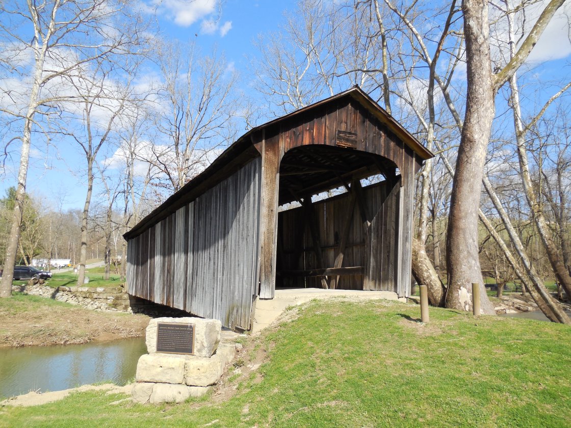
Johnsons Mill – Perry Township
Location: 39.999411, -81.839400
on Arch Hill Rd at the intersection of Murphy Hill Rd along Salt Creek
Remnants: Johnson’s Mill (Salt Creek) Covered Bridge on the south side of Arch Hill Rd just west of the GPS coordinates, historical markers at the bridge, Ebenezer Methodist (Carr) Cemetery on the south side of Carr Rd about 3/4 of a mile east of the GPS coordinates
Description: It was named after James S. Johnson (1817 – 1893) and Lucinda (Galloway) Johnson (1823 – 1869) who were the owners of a grist mill and saw mill that was next to Salt Creek near the covered bridge. They inherited a farm from Lucinda’s parents, had 10 children, and the family’s land holdings eventually expanded to 900 acres with their success. The bridge was constructed in 1876 and restored in 1998. It features 3 historical markers, one inside concerning the restoration and a couple more on the outside of the western end with info about its history. James and Lucinda were buried with relatives in Salem Cemetery about 2 1/2 miles north of the GPS coordinates at the intersection of Norfield Rd (Co Hwy 64) and Salem Church Rd in Salem Township. Some other residents were laid to rest in Ebenezer (Carr) Cemetery which was the site of a church and was established on a farm owned by the Carr family.
Lawton – Salt Creek Township
Location: 39.892031 -81.871275
on Salt Creek Dr (Co Hwy 196) along the Muskingum River between SR 146 (Chandlersville Rd) and Burnt Mill Rd
Remnants: none known
Description: Lawton was on the Ohio River & Western Railroad and had a passenger shelter and freight station built in 1916.
Lewis – Newton Township
Location: 39.881541, -82.039592
on Moxadarla Dr along the Moxahala Creek between Shaw Rd and Darlington Dr
Remnants: old houses and farm buildings in the area
Description: The proprietors were James J. Lewis (1830 – 1903) and Prudence (Holcomb) Lewis (1836 – 1902). They got married in 1860 and owned a 68-acre farm on the north side of the GPS coordinates. The Wilmington & Zanesville Railroad rolled through the vicinity with a stop a Newton Station just to the east on Darlington Dr. The area currently goes by the name of Darlington. James and Prudence were laid to rest 4 miles north of the GPS coordinates in Woodlawn Cemetery on Pershing Rd in Zanesville.
Maddens – Falls and Muskingum Township
Location: 40.007467, -81.983169
on Bellview Dr at the intersection of Fairfield Rd along the Muskingum River
Remnants: none known
Description: The proprietor Walter Scott Madden Sr. (1857 – 1916) had a stop at his farm on the Wheeling & Lake Erie Railroad in the late 1800s to early 1900s. Walter was married twice and was buried with relatives in Dresden Cemetery at the intersection of Main St and Lock St in Dresden.
McCrea Park – Newton Township
Location: unknown
Description: McCrea Park was a resort community south of Uniontown founded by the Columbus, Shawnee, & Hocking Railroad in the late 1800s.
Opera – Hopewell and Newton Township, Muskingum County and Madison Township, Perry County
Post Office: 1881 – 1901
Location: 39.909847, -82.169810
on Township Hwy 108 at the intersection of Asbury Chapel Rd along Kent Run
Remnants: Jack’s Hollow (Dolling’s) Covered Bridge on Township Hwy 108 about 1/4 of a mile south of the GPS coordinates, old houses and farm buildings in the area
Description: Opera was a small farming and postal town. Louisa E. Dollings (1845 – 1925) was the first postmaster when the office was in Muskingum County. She was buried with relatives in Asbury Chapel Cemetery 1 1/2 miles north of the GPS coordinates at the intersection of S Hopewell Dr and Asbury Chapel Rd. The post office moved to Perry County and Charles W. Stine (1853 – 1914) was the last known postmaster. He was buried with relatives in Wesley Union Cemetery about 5 miles southeast of the GPS coordinates on the west side of Wesley Chapel Rd. Jack’s Hollow Covered Bridge, also known as Dolling’s Covered Bridge, was completed in 1879 and has since been restored.
Pierce – Salt Creek Township
Location: 39.893685, -81.883638
on Wilhelm Rd along Boggs Creek between Taylor Ln and Salt Creek Dr
Remnants: none known
Description: Pierce was originally on the on Bellaire, Zanesville, & Cincinnati Railroad in the late 1800s to early 1900s. The Ohio River & Western Railroad had a passenger shelter constructed there in 1912.
Pleasant Valley (Licking Valley) – Hopewell, Licking, and Falls Township
Post Office: 1855 – 1900 and 1900 – 1957
Location: 40.017844, -82.125418
on the east side of Pleasant Valley Rd (Co Hwy 408) partially submerged by Dillon Lake
Remnants: Pleasant Valley Baptist Church and Cemetery on the eastern end of Pleasant Valley Church Rd
Description: The town was originally called Licking Valley and had a train station on the Central Ohio Railroad (later bought by the B&O). Civil War veteran Joseph R. Miller (1832 – 1885) was the first known postmaster. He was buried with relatives in Greenwood Cemetery on Greenwood Ave in Zanesville. Pleasant Valley Baptist Church was built in 1867. The town also had a general store, blacksmith shop, pottery shop, and a grist mill and saw mill in its early years. The post office name changed to Pleasant Valley in 1900. Construction of Dillion Dam began in 1946, but stopped due to lack of funding and the outbreak of the Korean War. Construction resumed in 1958 and was completed in 1961. As with most of Ohio’s human made lakes, it was for a flood control project and the land where the lake now is was considered to be expendable, despite displacing residents and submerging history. However, the history is what it is and there are also many benefits to the recreational lakes. Dillon State Park offers all of the usual activities, including camping, hiking, fishing, boating, and much more.
Dillon State Park Info – http://parks.ohiodnr.gov/dillon
Rich Hill – Rich Hill Township
Post Office: 1843 – 1863
Location: 39.909953, -81.752470
on SR 313 (Claysville Rd) between Township Hwy 208 and Perl Rd
Remnants: Rich Hill Cemetery on the east side of Co Hwy 448 about 1/2 of a mile southwest of the GPS coordinates, Salt Creek Cemetery at the intersection of SR 313 and Township Hwy 208
Description: Rich Hill was a farming and postal town with 2 local church congregations. There was a Methodist church (Rich Hill Chapel) on the north side of SR 313 near the GPS coordinates and a United Presbyterian church at Salt Creek Cemetery. John Randall (1792 – 1850) from Rensselaer County, New York was the first postmaster ad was buried with relatives in Rich Hill Cemetery. Irish immigrant Thomas Shepherd (1797 – 1851) was the next postmaster and was buried with relatives in Salt Creek Cemetery. He was succeeded by Leander L. West (1808 – 1874) from Loudon County, Virginia. Leander was also buried with relatives and other residents in Rich Hill Cemetery. Over the passing decades of the mid to late 1800s, the area’s accommodations moved to Rix Mills.
Ridgefield
Post Office: 1839 – 1841
Location: unknown
Description: John Monroe was the postmaster.
Ridgeway (Confederate Crossroads) (Keifer) – Blue Rock Township
Post Office: 1850 – 1857, 1869 – 1872, and 1872 – 1902
Location: 39.833454, -81.835855
on Ridgeview Rd between Browning Rd and Wion Ridge Rd
Remnants: none known
Description: It was a small farming and postal town with a school on the east side of Cutler Lake Rd south of the GPS coordinates in the mid-1800s. The post office’s name was originally Ridgeway. It changed to Confederate Crossroads in 1869 and the center of town moved to the intersection ofCutler Lake Rd and Ridgeview Rd along Manns Fork Salt Creek. The post office was renamed Keifer in 1872. There were several postmasters over the years. The first known person to hold the office was Noah M. Grandstaff (1817 – 1863). Noah was a Freemason and moved out of state where he passed away and was buried in Antioch Lutheran Cemetery on the south side of Hoagland Rd in Allen County, Indiana. Allen M. Frazier (1829 – 1909) was the first known postmaster of the Keifer office. He was buried with relatives in Sugar Grove Cemetery about 3 miles northeast of the GPS coordinates on the east side of Sugargrove Rd in Salt Creek Township. J. E. Smith was the last known postmaster.
Saint Clair – Rich Hill Township
Location: 39.861906, -81.701333
on SR 146 (Chandlersville Rd) at the intersection of Watson Rd along Mays Fork
Remnants: former train station on private property on the farm in the northeast corner of the intersection
Description: It was originally on the Bellaire, Zanesville, & Cincinnati Railroad in the late 1800s to early 1900s and was named after the St Clair family in the county. The town was later on the Ohio River & Western Railroad. The former train station was constructed in 1902 and is currently used as a storage shed.
Saintfield – Madison Township
Post Office: 1840 – 1863
Location: unknown
Description: Saintfield was in eastern Madison Township. Irish immigrant George Smyth (1792 – 1850) was the first postmaster. He was buried with relatives in Adamsville Baptist Cemetery on the south side of SR 93 (Cambridge St) in Adamsville in Salem Township. Thomas Armstrong (1799 – 1870) was the last postmaster and was buried with relatives in Saint Matthews Episcopal Cemetery on the north side of Stone Church Rd between Johson Hill Rd and Keyes Rd (Co Hwy 114).
Sealover – Brush Creek Township
Post Office: 1887 – 1888
Location: 39.873297, -81.964662
on Old River Rd along the Muskingum River at the intersection of Sealover Hollow Rd
Remnants: none known
Description: It was on the Zanesville & Ohio River Railroad (later bought by the B&O) and was named after the Sealover family in the county.
Seawright – Salt Creek Township
Location: 39.899256 -81.853120
on the south side of SR 146 (Chandlersville Rd) along Buffalo Fork south of the southern end of Rowland Ln
Remnants: none known
Description: Seawright was originally on the Bellaire, Zanesville, & Cincinnati Railroad. It had a passenger shelter built on the Ohio River & Western Railroad in 1915.
Sims Valley – Adams Township
Post Office: 1841 – 1842
Location: 40.126759, -81.901236
on Stone Church Rd at the intersection of Bethesda Church Rd along Symmes Creek
Remnants: Bethesda Cemetery on the east side of Bethesda Church Rd south of the GPS coordinates
Description: It was named after the Sims family in the county. William Willis (born c. 1792) from Pennsylvania was the postmaster and owned a saw mill near the GPS coordinates on Symmes Creek.
Smith (Smiths) – Rich Hill Township
Location: 39.889510, -81.803512
on SR 146 (Chandlersville Rd) along Buffalo Fork between Pryor Rd and Amby Ln
Remnants: old houses and farm buildings in the area
Description: It was on the Ohio River & Western Railroad and had a passenger shelter constructed in 1915. The station was on a 90-acre farm on the south side of the GPS coordinates on land owned by Ida (McClelland) Moore (1861 – 1935) from Pennyslvania. Ida was laid to rest with relatives in Greenwood Cemetery on Greenwood Ave in Zanesville.
Stony Point (Stoney Point) – Highland Township
Location: 40.063846, -81.744984
on SR 83 (Friendship Dr) at the intersection of Stoney Point Rd
Remnants: Stoney Point Farm on the south side of Stoney Point Rd about 1/2 of a mile east of the intersection
Description: Stony Point was named after its rocky terrain and had a school on the east side of SR 83 north of the GPS coordinates on land donated by David Morrow (1829 – 1899) and Margaret (McDowell) Morrow (1832 – 1921). Margaret was an Irish immigrant and married David in 1855. They were buried with relatives and other residents in Bloomfield Cemetery about 1 1/3 miles southeast of the GPS coordinates on the south side of SR 209 (Cambridge Rd). Descendants of the Morrow family own Stoney Point Farm and continue the tradition of livestock raising in the area.
Stoney Point Farm Info – https://www.stoneypointboers.com/index.html
Symmes Creek – Madison Township
Post Office: 1847 – 1880
Location: 40.067838, -81.958511
on Church Hill Rd (Co Hwy 155) between Old Ferry Rd and Black Shake Ln
Remnants: Salem Methodist Cemetery in the northeast corner of the intersection of Church Hill Rd and Blake Shake Ln
Description: It was a farming town with a post office that moved around some over the decades. The first postmaster was Charles J. Love (born c. 1816) from Virginia. Civil War veteran Daniel F. Kinney (1836 – 1899) was the last postmaster. He was buried with relatives in Salem Church Cemetery at the intersection of Norfield Rd (Co Hwy 64) and Salem Church Rd in Salem Township.
Webbsport – Jefferson Township
Location: unknown
Description: It was on the Ohio & Erie Canal in the mid-1800s.
Zanesville, OH – (1799 – present farming, canal and railroad town)
Classification: historic town
Location: City of Zanesville, Muskingum County – Exits off of I-70 and US 40 (National Road)
Zanesville was named after Ebenezer Zane (1747 – 1811) who blazed Zane’s Trace, an early pioneer road that went from Wheeling, West Virginia to Marysville, Kentucky. The town of Zanesville was platted in 1799 by Ebenezer’s son-in- law John McIntire (1759 – 1815) near the confluence of the Muskingum River and Licking River on land that was basically his marriage dowry. John also operated a hotel and a ferry. Zanesville grew quickly with its good location and started booming with the completion of the Muskingum River Navigation System in 1841.
Ohio Historical Marker #9 – 60 near a park on Main St next to the Y Bridge tells the story of the locks. They were large enough to accommodate newer steam boats and trade around the area flourished. The Y Bridges are highlighted by Ohio Historical Marker #3 – 60 at the “3 Y’s” of the bridge. It’s the only bridge in the U.S. with that unique shape.
In the mid – late 1800s, Zanesville had a second population boom with an extensive railroad system going through town. There were several train stations over the decades. The Zanesville Terminal Railroad Station at the corner of 3rd St and Market St was built in 1917 and is currently used for offices. It closed in 1968, was restored in 1989, and is on the National Register of Historic Places. Another station that was on the Wheeling & Lake Erie Railroad sits at the corner of Linden Ave and McIntire Ave. Zanesville also had lots of pottery shops which opened up after clay was found in the region. Ohio Historical Marker #16 – 60 on Linden Ave in front of the Roseville Pottery building has info about the company and industry. There are also a few other Ohio Historical Markers in town.

