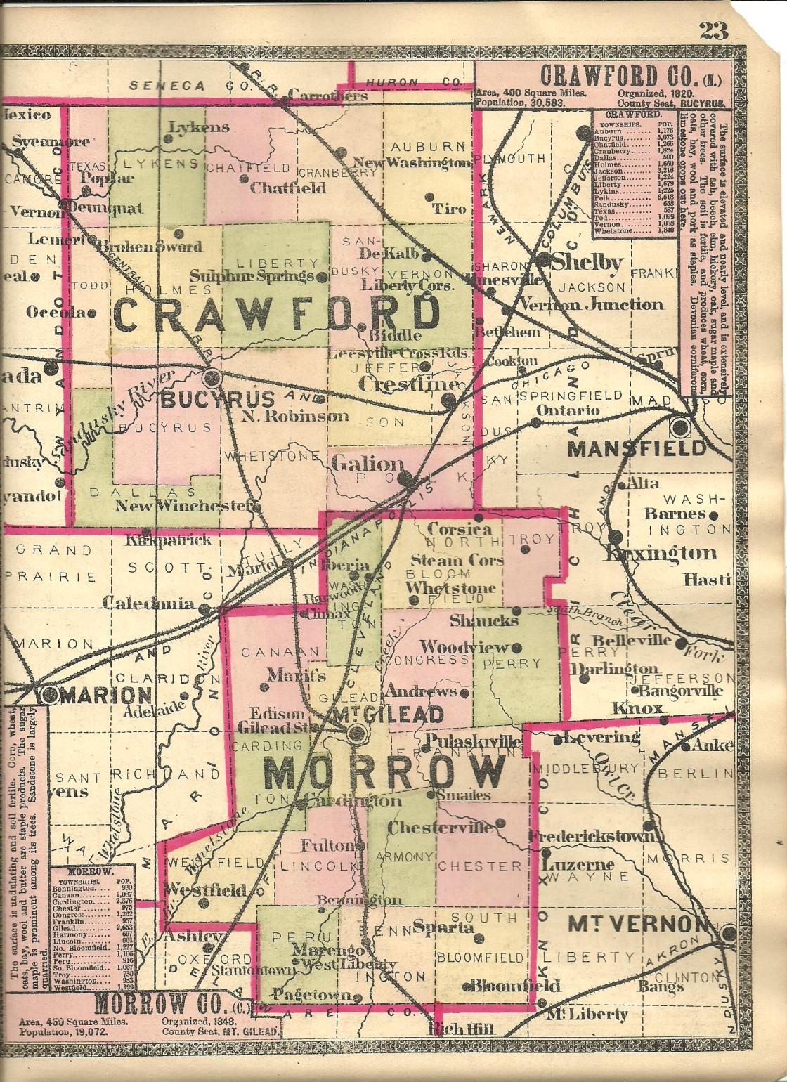
Aaronsburg – South Bloomfield Township (formerly in Knox County)
Location: 40.398278, -82.695259
on SR 229 at the 4-way intersection of SR 656 and Columbus Fredericktown Rd
Remnants: none known
Description: Aaron Macomber (or McComber) arrived in the area in 1823 and had a wood bowl making business with a horse-powered turning machine. He platted Aaronsburg in 1824. A wool hat shop was owned by Hugh Hartshorn who also sold lambs from his stock. The residential lots in Aaronsburg never sold and the idea was quickly abandoned. It’s unknown where Aaron and Hugh went after the town failed. Other than what is listed here, retrieved from the old county history books, the only records on them are Knox County tax assessments from the 1820s to early 1830s.
Barcelona – North Bloomfield Township (formerly in Bloomfield Township, Richland County)
Post Office: 1833 – 1841
Location: 40.667521, -82.718522
on Williamsport – Williamsburg Rd (Co Rd 20) at the intersection of Iberia – Bellville Rd
Remnants: none known
Description: Barcelona was a small farming and postal town with William Wallace as the postmaster. William was also a farmer and raised cattle. The post office moved to Blooming Grove.
Florida Grove – Franklin Township (formerly in Knox County)
Location: 40.550646, -82.776749
on Cardington Williamsport Rd at the intersection of Town Hwy 104 (Township Hwy 104)
Remnants: none known
Description: Florida Grove was founded in the early 1820s by Reverend George Vaneman (or VanEman) (1786 – 1870) from Pennsylvania, Plumb Sutleff, and Samuel Hardenbrook. Some of the residential lots sold but the town never flourished and reverted back to farmland by the mid-1800s. George was married twice, had at least 6 children, and was buried with relatives in Maple Grove Cemetery on SR 12 (W Main Cross St) in Findlay, Hancock County.
Friendsboro (Friendsborough) (Moshers Mill) – Cardington and Gilead Township (formerly in Marion County)
Location: 40.517140, -82.866684
on US 42 (Gilead St) at the intersection of Mosher Rd (Township Hwy 144) along Whetstone Creek
Remnants: Union Cemetery 1 mile east of the GPS coordinates on the south side of US 42
Description: Asa Mosher (1771 – 1843) and Bethiah Mosher (1771 – 1856) were Quakers who moved to Ohio from Bristol County, Massachusetts. They had 11 children and built a grist mill and saw mill next to Whetstone Creek in 1821. Friendsboro was platted near the mills the following year by surveyor and War of 1812 veteran Colonel James Kilbourn (1770 – 1850) who founded Worthington in Franklin County and a few smaller towns around Ohio. Asa bought up most of the lots to make a farm for one of his sons, Robert Mosher (1800 – 1886), so Robert could live close enough to efficiently operate the mills. Asa wouldn’t sell one of the lots to John Roy (1798 – 1878) from Somerset County, New Jersey who wanted to build a general store. Although it would have split up the Moshers land, the refusal was likely a great loss to Friendsboro, as John set up shop at the future site of Mount Gilead and became very successful there. He moved to Lyndon, Illinois in 1839 and opened another general store and a hotel. John was buried with relatives in Grove Hill Cemetery on N Madison St in Morrison in Whiteside County, Illinois. Asa did sell a plat lot to John Shaw (1803 – 1880) from Pennsylvania who built a cabinet shop next to Whetstone Creek, but the water power was insufficient for its needs and the town never ended up growing any. John shaw was laid to rest with relatives 4 miles northeast of the GPS coordinates in River Cliff Union Cemetery on E Marion St in Mount Gilead. Asa, Bethiah, and Robert Mosher were buried with relatives in Union Cemetery.
Grays Corners (Gray’s Corners) – Harmony Township
Post Office: 1858 – 1865
Location: 40.461113, -82.783302
on Waldo – Fulton – Chesterville Rd at the intersection of Bennington – Harmony – Central Rd (Co Hwy 170)
Remnants: none known
Description: The proprietors were Alexander Gray (1819 – 1877) and Sarah (Rees) Gray (1839 – 1923). They were both born in Pennsylvania and owned a 79-acre farm in the southwest lot of the intersection. Alexander was the town’s postmaster and served as county commissioner from 1853 – 1856. A school was in the northwest corner of the intersection on a farm owned by the Phillips family. It was replaced by a newer structure on the south side of Waldo – Fulton – Chesterville Rd just west of the GPS coordinates sometime between publication of the 1857 county map and 1871 county atlas. Alexander and Sarah had a daughter and were buried with relatives in Ebenezer Cemetery about 4 1/2 miles southwest of the GPS coordinates on the west side of the intersection of SR 61 and Bennington Harmon Rd (Township Rd 191) in Lincoln Township.
Jamestown (Kelly’s Corner) (Sandusky Cross Roads) (Sandusky X Roads) – Franklin Township (formerly in Knox County)
Post Office: 1824 – 1836
Location: 40.538653, -82.777809
on SR 95 at the 4-way intersection of Criswell Rd (Township Hwy 116) and Pulaskiville Rd
Remnants: none known
Description: It was the first village in the township and was platted in 1824 by James Bailey at what was once close to the corner of four counties. James build a general store near the GPS coordinates and Appleton Rich opened a blacksmith shop. The store was bought by Allen Kelly (1785 – 1871) from Pennsylvania and Miriam (Dicus) Kelly (1792 – 1849) from Delaware. Allen was the town’s postmaster. The office was originally listed in postal records Sandusky Cross Roads and later as Sandusky X Roads. Allen also opened a tannery and was a farmer and raised livestock. He made several trips to Philadelphia, Pennsylvania to bring fine herds of cattle back to Ohio. The Kellys sold the store to brothers Richard J. House (1798 – 1884) and Nathan House (1799 – 1845) from Chester County, Pennsylvania around 1828. The House brothers moved their goods to the rapidly growing town of Mount Gilead in the mid-1830s and were buried there with relatives in River Cliff Union Cemetery on E Marion St. Allen Kelly accumulated about 740 acres of farmland in western Franklin Township by the late 1850s. On top of its failure to compete with Mount Gilead, the reorganization of Ohio’s counties in the mid-1800s took the town away from its previous prime location. Allen and Miriam had a few children and were buried with many relatives in Bryn Zion Cemetery 2 miles north of the GPS coordinates at the intersection of Cardington Williamsport Rd and Bryn Zion Rd in Gilead Township.
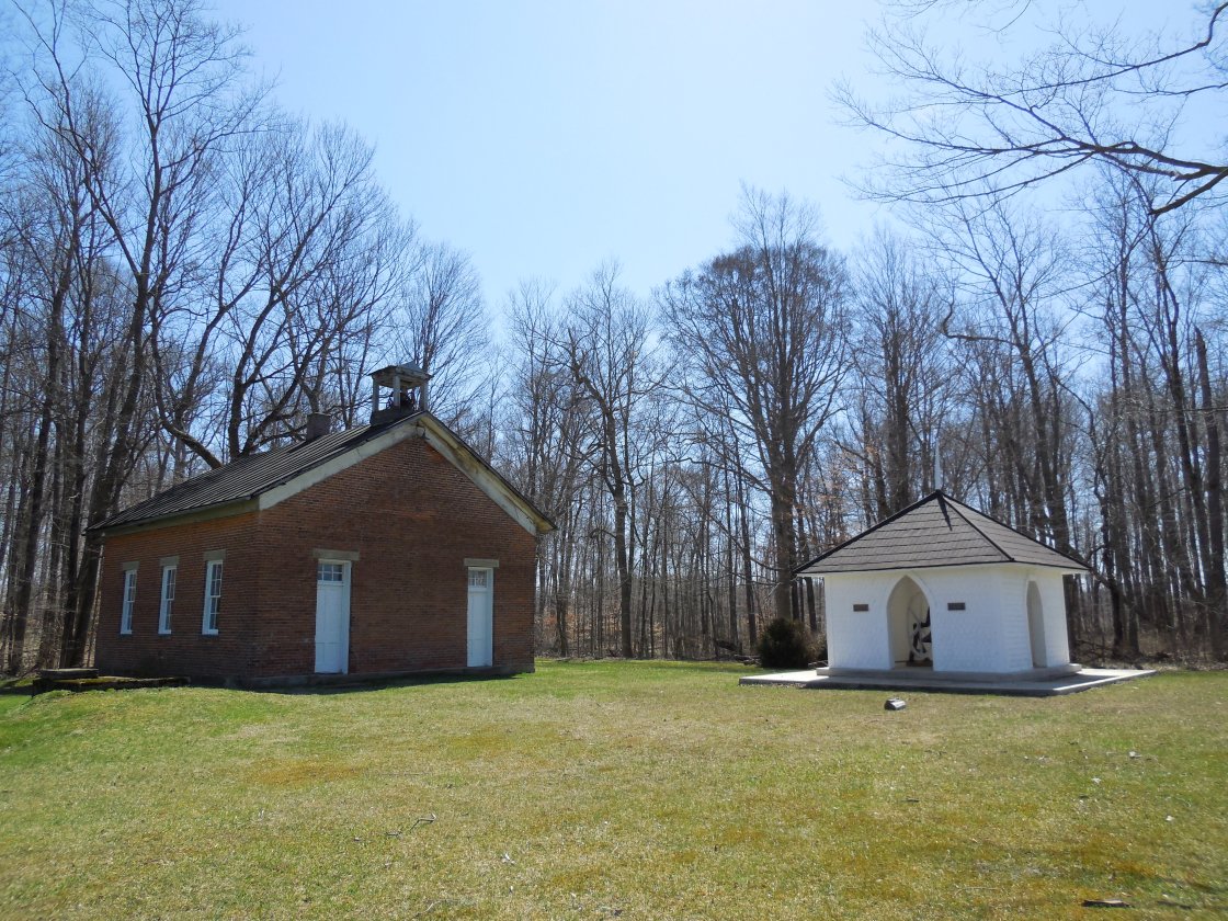
Kelker – Congress Township
Post Office: 1898 – 1903
Location: 40.616600, -82.747231
on Williamsport Crestline Rd between Marion – Johnsville Rd and Trimbe Rd
Remnants: Pleasant Grove Cemetery on the west side of the GPS coordinates, former one-room schoolhouse across the road from the cemetery, former church bell with a memorial and historical plaques
Description: The proprietors were Rudolph F. Kelker (1841 – 1908) and Ida (Cook) Kelker (1836 – 1909). They got married in 1862, had a few children, and owned an 80-acre farm on the northwest side of the GPS coordinates. Rudolph was the town’s postmaster. The church congregation, cemetery, and former school all predate the establishment of the town. The school was on an 80-acre farm owned by James P. Maxwell (1818 – 1898) from Pennsylvania and Susan (Swallum) Maxwell (1822 – 1902). It’s currently in excellent preserved condition. There are two unusual things about the school. The first is its bell is still intact in the tower. The only other location we have seen the same occurrence is at the ghost town of Oak Grove in Meigs County. Another unusual aspect of the school is the fact that it has two doors, likely one for boys and the other for girls, just like many churches from the time period. It goes to show how much influence the church had in the community. James Maxwell was also an elder member of the congregation for almost 50 years. An older wood frame church on the south side of the cemetery was demolished in the late 2010s. It was constructed in 1858 and replaced the congregation’s former log building. The very large bell from the wood frame church has been restored and hung in a memorial with a couple of historical plaques that have info concerning the history of the church buildings. To accommodate the congregation’s growing numbers, the much larger brick structure on the north side of the school across from the cemetery was completed in 1969. Everyone mentioned in this listing was buried with relatives and other residents of Kelker in the cemetery.
Morehouse (Morehouse Settlement) – Peru Township (formerly in Delaware County)
Location: 40.407010, -82.901775
on SR 229 (Marengo – Norton) along Turkey Run between Kilbourne – Cardington Rd (Co Hwy 165) and Benedict Rd (Township Hwy 221)
Remnants: Morehouse Cemetery on the north side of the GPS coordinates
Description: It was founded in 1830 by Stephen Morehouse Sr. (1771 – 1855) and Elizabeth (Steinbeck) Morehouse (1775 – 1868). They had 11 children, moved to Ohio from New Jersey, and owned a farm where the cemetery was established. Some of their children also made the journey to Ohio and some stayed behind. A steam-powered saw mill was on the west side of Kilbourne – Cardington Rd about 1 mile northwest of the GPS coordinates on a farm owned by the Coomer family. The Moorehouse family also had several saw mills and a couple of tanneries over the years. A school was on Stephen and Elizabeth’s farm on the northeast side of the GPS coordinates across from the cemetery. It was replaced by a newer school on the west side of Kilbourne – Cardington Rd about 3/4 of a mile southwest of the GPS coordinates prior to publication of the 1871 county atlas. Stephen and Elizabeth were buried with relatives and other residents in Morehouse Cemetery.
Peerless (Peerless Station) – Bennington Township, Morrow County and Porter Township, Delaware County
Post Office: 1881 – 1910
Location: 40.350507, -82.765348
on Peerless Rd (Mt Vernon Olive Green Rd) along Long Run at the former railroad crossing between SR 656 and Moody Rd
Remnants: old houses and farms in the area
Description: Peerless had a train station on the Toledo & Ohio Central Railroad. A school was on the west side of Moody Rd about 1 miles southeast of the GPS coordinates. John W. Morehouse (1842 – 1913) was the first known postmaster and was buried with relatives in Ashley Union Cemetery about 14 miles northwest of the GPS coordinates on the east side of Ashley Rd in Oxford Township. John E. Wells (1852 – 1926) was the next known postmaster and was laid to rest with relatives 4 miles northeast of the GPS coordinates in Bloomfield Cemetery on the east side of Rich Hill Bloomfield Rd (Township Hwy 199) in S Bloomfield Township. Thomas Cubbage Jr. (1854 – 1928) from Kent County, Delaware was the last known postmaster. He later moved and was laid to rest in Maple Grove Cemetery on Maple Dr in Alexandria, Licking County. The train station was purchased by a local farmer in 1941 and was converted to a corn crib.
Penlan – Harmony Township
Post Office: 1898 – 1901
Location: 40.445441, -82.746309
on Penlan Rd (Co Rd 184) at the intersection of Township Rd 179
Remnants: Mt Pisgah Baptist Church in the southwest corner of the intersection, old houses and farm buildings in the area
Description: This crossroads town had a general store and there was a school on the east side of Penlan Rd 1/3 of a mile south of the GPS coordinates. Mt Pisgah Baptist Church was constructed in the mid-1870s. The first postmaster’s last name, Frank. M., is unreadable in the 1899 Official Register of the United States. Darius J. Benson (1848 – 1904) was the last known postmaster and was buried with relatives in Cemetery 10 3/4 miles northwest of the GPS coordinates on Glendale St in the Village of Cardington. The post office was discontinued due to the implementation of a RFD (Rural Free Delivery) mail route through the area.
Queen Settlement – Canaan Township (formerly in Marion County)
Location: unknown
Description: The town was founded in the 1830s by War of 1812 veteran William Queen (1789 – 1851) and Elizabeth Queen (1795 – 1879) who moved to Ohio from Virginia and had at least 3 children. Church services were held in a log schoolhouse until a wood frame church was built in 1866 at a cost of $1,100. William and Elizabeth were buried with relatives in Glendale Cemetery on Glendale St in the Village of Cardington.
Rome – South Bloomfield Township (formerly in Knox County)
Location: 40.408746, -82.705308
on SR 314 (Chesterville – Sparta Rd) at the intersection of Prospect Mt Vernon Rd
Remnants: none known
Description: It was platted in 1827 by Lemuel Potter (1778 – 1860) from Rhode Island and Anna (Terry) Potter (1785 – 1849). They operated a tavern near the GPS coordinates from 1830 – 1840 but the town failed to sell plat lots. Lemuel and Anna had at least 4 children and were buried with relatives in Bloomfield Cemetery 2 1/2 miles southwest of the GPS coordinates on the east side of Rich Hill Bloomfield Rd.
Steiners Corners (Stiners Corner) – Lincoln Township (formerly in Delaware County)
Location: 40.481369, -82.820646
on SR 61 at the intersection of SR 529 (Cardinton – Chesterville Rd) along Alum Creek
Remnants: Asbury (Steiners Corners) Cemetery on the south side of SR 529 just west of the intersection, Buck Cemetery on the north side of SR 529 across from Asbury Cemetery
Description: Steiners Corners was a bustling little town founded by William Stiner (1772 – 1837) from Maryland and Marian (Smith) Stiner (1792 – 1874). William moved to Fairfield County at a young age and married Marian in 1807. They subsequently moved to what would later become Morrow County and had 14 children. In the mid-1800s the town had a steam-powered saw mill in the southeast corner of the intersection on a 180-acre farm owned by James Rose (1811 – 1890) from Bedford County, Pennsylvania and Nancy (Gordon) Rose (1812 – 1891) from Perry County. They got married in 1832 and moved to Sandusky County in 1834. James served 3 years as county commissioner and 18 years as a justice of the peace in Sandusky County before moving the family to Lincoln Township in 1854 where he served as a township trustee. James and Nancy had 11 children and were laid to rest with relatives in Glendale Cemetery 4 1/2 miles northwest of the GPS coordinates on Glendale St in the Village of Cardington. A regular saw mill was in the southwest corner of the intersection on the old Stiner homestead. A Methodist Episcopal church was in the northwest corner of the intersection next to Buck Cemetery on and 85-acre farm owned by Edmund Buck (1791 – 1866) from Clinton County, New York and Anna (Hubble) Buck (1795 – 1874) from Seneca County, New York. They got married in 1815, had 7 children, and were laid to rest with relatives and other residents in Buck Cemetery. The Buck family was related by marriage to the Stiner, Rose, and Mosher families. A school was in the northeast corner of the intersection. The school was replaced by a newer one on the east side of SR 61 just south of the GPS coordinates prior to publication of the 1871 county atlas. William and Marian were buried with relatives and other residents Asbury Cemetery which was established on their farm. Steiners Corners faded into obscurity in the late 1800s.
Surprise – Washington Township (formerly in Marion County)
Post Office: 1890 – 1903
Location: 40.610768, -82.842082
on Marion – Williamsport Rd (Co Rd 61) at the intersection of Mt Gilead – Iberia Galion Rd along Shaw Creek
Remnants: none known
Description: This farming and postal town was on the Cleveland, Cincinnati, Chicago, & St. Louis Railroad (Big Four Railroad). It had a school on the south side of Marion – Williamsport Rd about 1/4 of a mile west of the GPS coordinates on land owned by the Newson family. The first known postmaster was Joshua M. Davis (1829 – 1900) from Greene County, Pennsylvania. He was buried with relatives in Iberia Cemetery 4 1/2 miles north of the GPS coordinates on the south side of Iberia – Bellville Rd in Iberia. Judson Freeman was the last known postmaster.
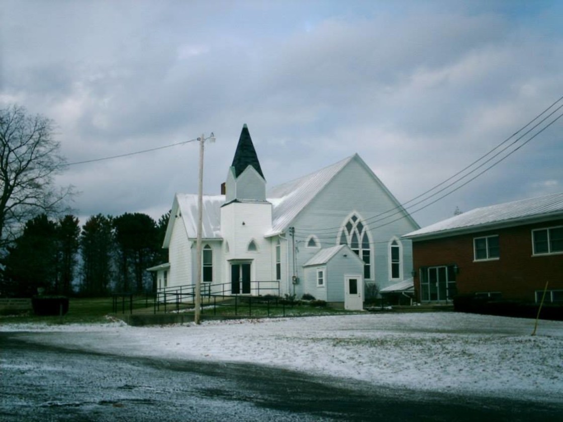
Steam Corners, OH – (mid-1800s – present farming and saw mill town with less residents than in the past)
Classification: small town
Location: Troy Township, Morrow County – On Steam Corners – Lexington Rd at the intersection of SR 314 (Chesterville – Shelby Rd)
The town was first settled in the 1850s as a small farming community. It had population boom in the early 1860s when a steam-powered saw mill was constructed nearby, so they started to call the area Steam Corners. A post office moved into town in 1864 but was later discontinued. A new post office was built that ran from 1865 – 1901. The first store in town also opened in 1865. In the late 1800s to early 1900s, Steam Corners had a school, church, general store, tavern, wagon shop, and a blacksmith.
There isn’t much left in town besides a Methodist church that sits next to the last school the town had and maybe 20 homes. Its biggest attraction these days is the Mid-Ohio Sports Car Course about a mile east of Steam Corners on Steam Corners – Lexington Rd.