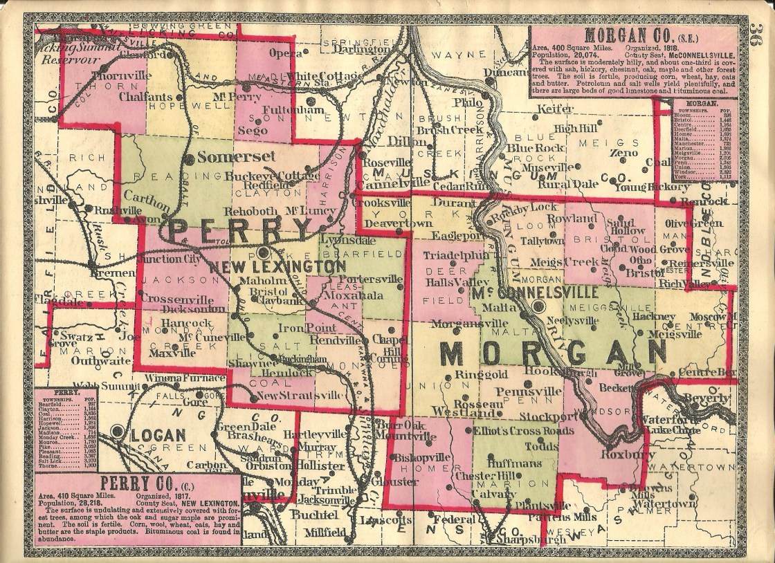
Airington (Talleytown) – Bloom and Bristol Township
Location: 39.733404, -81.809300
on Richardson Rd (Township Rd 276 about 2 miles south of SR 376
Remnants: Mt Zion Cemetery on the west side of Lawrence Rd (Township Rd 952) southwest of the GPS coordinates, Airington Cemetery in the woods on the east side of Richardson Rd
Description: The town was founded by John F. Talley (1799 – 1886) from Chester County, Pennsylvania and Hannah (Paulson) Talley (1793 – 1857). They got married in 1819, settled in Bloom Township that same year, and had a few children. John severed as county surveyor, justice of the peace, and the family owned a general store. In the mid to late 1830s, Airington acquired a blacksmith shop, wagon shop, cabinet maker, a cooper shop (barrels), a tailor, shoemaker, and had a couple of stores. A Methodist Church sat next to Mt Zion Cemetery. Farming and livestock raising were the town’s major industries. Airington never had a population boom though and quickly began declining when the Talleys sold their farm in 1882. As stated in the 1886 county history book, “The village is in ruins and only two families remain.” It somehow survived long enough to make it into the 1902 county atlas and faded into oblivion shortly after that. John and Hannah were buried with relatives in Airington Cemetery. The cemetery was also pinpointed in the 1902 county atlas, but the road it was on has long since disappeared.
Blackburn – Union Township
Post Office: 1897 – 1905
Location: 39.560262, -82.024643
on E Branch Rd on the northeast side of Burr Oak Lake
Remnants: Fairview Mission church and Cemetery on the south side of Mountville Rd, old houses and farm buildings in the area
Description: It was named after the Blackburn family that lived in the area in the late 1800s and had a school (Union Township No. 9) on the east side of E Branch Rd in the northwest corner of the 80-acre Blackburn farm. William Wesley Acker (1853 – 1938) was the postmaster. He later moved with his family and was buried in Salem Cemetery on the west side of Salem Hollow Rd SE in Ward Township, Hocking County. The post office location appears to now be underwater and was on a large farm owned by William A. Shepard (1842 – 1924) and Georgia (Peddicort) Shepard (1844 – 1915). There was a Methodist church on the Shepard farm near the southern border of Union Township. William and Georgia relocated to Franklin County and were laid to rest in Green Lawn Cemetery on Greenlawn Ave in Columbus. Unlike many of the other partially underwater towns we have researched, Blackburn lost its existence well before Burr Oak Lake was constructed in 1950. The community of Vicksville now sits on the old Shepard homestead. Some of the residents of Blackburn were buried in Fairview Cemetery.
Brill – Bristol Township
Post Office: 1900 – 1908
Location: 39.735122, -81.708240
on SR 83 at the intersection of Grove Church Rd
Remnants: none known
Description: The town was named after the Brill family in the area and had a school (Bristol Township No. 6 west of Grove Church Rd on an 87-acre farm owned by Samuel Gibbs (b. 1842) and Abigail Gibbs (1846 – 1899). Samuel was a shoemaker by trade and had a shop in the woods just north of the intersection. It’s unclear if he remarried after Abigail passed away and we were unable to confirm that through genealogy records. In any case, Grace Gibbs was town’s postmaster. Samuel and Abigail were buried with relatives and other residents in Oak Grove Cemetery about 1 3/4 miles north of the GPS coordinates on the east side of Grove Church Rd on the border with Meigs Township, Muskingum County.
Cabinville – Bristol Township
Location: 39.704338, -81.725366
on SR 83 at the intersection of SR 284
Remnants: Lebanon (Bristol) Cemetery on the north side of SR 83 / 78 about 1/2 of a mile southeast of the GPS coordinates
Description: Around the corner from the former town of Bristol and Big Muskie’s Bucket, the world’s largest excavating bucket, Cabinville is a bit of a mystery. It didn’t appear on any of the county maps we have access to and wasn’t listed in the 1886 county history book.
Chadwick – Windsor Township
Location: 39.512289, -81.750440
on Johnson Ridge Rd between Eckert Rd and Dale Rd
Remnants: Oakland Church and Cemetery on the south side of Johnson Ridge Rd 1 mile east of the GPS coordinates
Description: The proprietors were Justus Chadwick (1815 – 1899) from Athens County and Sarah (Cook) Chadwick (1816 – 1898) from Washington County. They got married in 1841, had 7 children, and accumulated 490 acres of land. Justus and Sarah were a couple of the most prominent farmers in the county and were founding members of the Oakland United Methodist Church. The congregation organized in 1854. Its first church structure was completed in 1871 at a cost of $1,250 on land owned by Edward Milner (1812 – 1887) and Bethsheba (Nichols) Milner (1817 – 1890) from Belmont County. The town had a school (Windsor Township No. 14) on the south side of Johnson Ridge Rd near the GPS coordinates. Justus and Sarah were buried with relatives and other residents, including the Milners, in Oakland Cemetery.
Chaneyville – Malta Township
Post Office: 1840 – 1850
Location: 39.624595, -81.912525
on SR 78 at the 4-way intersection N Best Rd (Co Rd 40) and McClure Ln
Remnants: Chaneyville Cemetery off of Brandberry Rd (Co Rd 47)
Description: The town was founded by the Chaney family in the township with Reverend Jonathan Chaney (1782 – 1820) being the earliest known arrival. It had a wagon and threshing machine shop from 1848 – 1864 owned by the Manly family. A school was on the north side of SR 78 near the GPS coordinates. William Harry was the first postmaster. He was succeeded by Isaac Walter (1810 – 1894). Isaac was laid to rest in Friend Cemetery about 2 1/2 miles east of the GPS coordinates on the west side of Big Oak Rd (Co Rd 4) at the intersection of SR 377. Chaneyville Cemetery is listed on Find A Grave as being in section 17 of Malta Township off of Brandberry Rd, but it doesn’t pop up on Google Maps. Chadwick and Chaneyville fell into obscurity prior to 1900 and didn’t make it onto the Ohio map in the 1901 George Cram atlas.
Cloud – Bristol Township
Post Office: 1884 – 1910
Location: 39.728449, -81.750429
on N Meigs Creek Rd NE at the intersection of Bristol Church Rd (Township Rd 944) along Meigs Creek
Remnants: Bristol Cemetery on the south side of Bristol Church Rd 1/2 of a mile east of the intersection
Description: Cloud was a small farming and postal town with a couple of local schools. One of them was on the west side of town near the western end of McGonagle Rd and the other on the east side of town was on the west side of SR 284 north of Bristol Church Rd. There was a Presbyterian Church at the cemetery. The land for the church and cemetery was donated by the Coulter and Henderson families. Matthew M. McDonald (1854 – 1929) was the first postmaster. He was buried with relatives in McConnelsville Cemetery on 14th St in McConnelsville. Joseph W. Macklem (1851 – 1936) was the last postmaster and was buried with relatives in Reinersville Cemetery on SR 78 in Reinersville.
Gardner – Homer Township (formerly in Athens County)
Location: 39.482507, -81.998354
on W Wrightstown Rd at the intersection of Fleming Rd along Miners Fork
Remnants: Liberty Hill Cemetery on the west side of W Wrightstown Rd 1 mile west of the GPS coordinates
Description: It was founded by Amos Gardner (1808 – 1890) and Mary (Humiston) Gardner (born c. 1814 – 1877). They were both born in Maine and moved to Homer Township in 1830. Amos and Mary had 5 children and owned a 169-acre farm at the GPS coordinates. There was a Methodist church next to Liberty Hill Cemetery on land donated by the Lefever family. Amos remarried after Mary passed away. They were buried with relatives in Bishopville Cemetery 5 miles northwest of the GPS coordinates on the west side of SR 78 in Bishopville just across the border in Trimble Township, Athens County. Most of the Lefever family was laid to rest in Liberty Hill Cemetery. There’s an abandoned house in the southeast lot of the GPS coordinates and a few abandoned farm buildings nearby, but they all have intact roofs and appear to have been constructed after Gardner lost its existence.
Halls Valley – Deerfield Township
Post Office: 1838 – 1899
Location: 39.663177, -81.955637
on SR 37 at the 4-way intersection of N Church Rd NW and N Finley Rd (Co Rd 25) along West Branch Wolf Creek
Remnants: Deerfield Presbyterian Church and Cemetery on N Church Rd NW north of the GPS coordinates
Description: The original proprietors were War of 1812 veteran Mills Hall (1787 – 1862) from Delaware and Nancy (Rees) Hall (1791 – 1876) from Virginia. Mills served as county commissioner in 1854 and was the town’s postmaster from 1838 until his death. He was succeeded by Thomas B. Smith (1821 – 1906), who later retired, and Thomas F. Price (1859 – 1932) took on the position. Sarah (Donehoe) Baldridge (1846 – 1908) was the last postmaster. Deerfield Presbyterian Church was organized in 1819. Its first log church structure was built in 1822 and was replaced by a frame building in 1839. Another frame church replaced the former one in 1859 and the current structure was completed in 1877. The town also had a steam-powered saw mill on the south side of SR 37 west of the GPS coordinates on the farm of Benjamin McDonald (1813 – 1905) from Pennsylvania and Mahala McDonald (1823 – 1903) from Maryland. Everyone mentioned in this listing was buried in Deerfield Cemetery.
Hickersons Cross Roads – Penn Township
Post Office: 1850 – 1853
Location: 39.595516, -81.915052
on S Elliott Rd (Co Rd 4) at the intersection of N Best Rd (Co Rd 40)
Remnants: Never-Never Fruit Farm House at 545 S Elliott Rd, Baptist (Mount Olive) Cemetery on the west side of S Elliott Rd about 2 miles south of the GPS coordinates
Description: The town was named after the Hickerson family in the township who owned much of the land along S Elliott Rd stretching from N Best Rd to Janes Rd. Shephen Jones (1797 – 1873) and Mary (Rowland) Jones (1797 – 1893) were both born in Maryland and got married in 1823. They owned the Never-Never Fruit Farm, which is still in existence, from 1846 – 1851 and passed it down to one of their sons. The farm has been owned by the Hickerson family since 1940. An interesting large sign listing the farm’s former owners is on the front of a clapboard covered log house that has been on the property since at least 1850. The sign also reads, “This farm so named because we never run out of work or friends”. There was a Baptist church at the cemetery on land donated by the Best family. A Methodist Episcopal church was on the south side of S Elliott Rd west of N Best Rd. The Methodist church was replaced with a school (Penn Township No. 5). Another school (Penn Township No. 4) was on the east side of S Elliott Rd across from the intersection of Janes Rd. Stephen and Mary Jones were buried with relatives and other residents, including some of the Hickersons and Bests, in Baptist Cemetery.
Huffmans – Marion Township (formerly in Athens County)
Post Office: 1872 – 1892
Location: 39.525864, -81.902980
on Neburn Rd along Goshen Creek between Wood Rd and Hoffman Rd
Remnants: none known
Description: The proprietors were George W. Huffman (1836 – 1924) and Mary (Devore) Huffman (1847 – 1886). George was the town’s postmaster and lived his entire life in the area. His parents, Henry Huffman (1813 – 1852) and Mary Huffman (1809 – 1888) moved to Ohio from Pennsylvania in 1834 and settled in Marion Township the year George was born. They had 10 children and owned a 280-acre farm on the west side of the GPS coordinates. It had a saw mill on the north side of Goshen Creek listed in the 1874 county atlas. George inherited his parents farm, had 6 children, and remarried after Mary passed away. Everyone mentioned in this listing was buried in Chesterhill Cemetery 5 miles southeast of the GPS coordinates on Buckeye Ridge Rd in Chesterhill.
Lewis – Homer Township
Post Office: 1891 – 1905
Location: 39.480575, -82.023594
on Cox Kolbe Rd between SR 329 and Black Rd along Hyde Fork
Remnants: Ferndale (Cary) Cemetery on private property on the west side of Cox Kolbe Rd south of the GPS coordinates
Description: It was along the Toledo & Ohio Central Railroad and was named after the Lewis family in the township. Alvah Cary (1856 – 1915) was the postmaster. He later moved to Franklin County and was buried with relatives in Green Lawn Cemetery on Greenlawn Ave in Columbus. Prior to the railroad’s arrival, the center of town was on SR 329 just south of Cable Ln (Township Rd 648) and was called Lewis Hill in the 1870s. It also had a post office back then, but the dates aren’t listed anywhere and a gun shop and a school on the east side of SR 329. The GPS coordinates are near the location of the Lewis post office and the railroad was just to the east along Hyde Fork. Many residents of Lewis, including some members of the Lewis family, were buried in Ferndale Cemetery.
Linscott – Homer Township, Morgan County and Ames Township, Athens County
Post Office: 1878 – 1903
Location: 39.460913, -82.043498
on Hooper Ridge Rd (Co Rd 86) at the intersection of Boudinot Ln
Remnants: Concord Church and Cemetery 1 miles south of the GPS Coordinates on Kasler Creek
Description: This small farming and postal town was founded by the Linscott family from Maine which owned land in both Ames and Homer Township. Albert W. Wolfe (1848 – 1926) was the postmaster. He moved to Franklin County and was buried with relatives in Green Lawn Cemetery on Greenlawn Ave in Columbus. The present Concord Church brick structure was completed in 1895. Some members of the Linscott family were buried in Concord and Hooper Ridge Cemeteries in Ames Township.
New Bedford – Bristol Township
Location: unknown
Description: New Bedford was listed in the 1841 The Ohio Gazetteer and Traveler’s Guide as a recently platted town. It had around a dozen houses, but appears to have quickly fizzled out and didn’t make it onto the 1854 county map.
Oil Spring – Malta Township
Location: 39.686615, -81.897245
on W Oil Spring Rd (Township Rd 195) between SR 669 and McCune Rd along Oilspring Run
Remnants: none known
Description: Isaac James (born c. 1790) from Virginia built a grist and saw mill next to Oilspring Run around 1820. The grist mill was later enlarged to grind both wheat and corn. The mills were last spotted on the 1854 county map. Oil Spring also had a school with William Sherwood (1801 – 1891) working as its first known teacher. William was buried with relatives in McConnelsville Cemetery on 14th St in McConnelsville. In the late 1800s, the area was called Shawnee Junction and still had a school and a United Brethren church. It was at the junction of the Columbus, Sandusky, & Hocking Railroad and the O&LK Railroad.
Otho – Manchester and Bristol Township
Post Office: 1884 – 1892
Location: 39.681382, -81.697872
on SR 83 / 78 along at the crossing of Dyes Fork between Bristol and Reinersville
Remnants: none known
Description: Otho was a tiny farming and postal town with a small cluster of houses around Dyes Fork. Civil War veteran William Hastings (1833 – 1904) was the postmaster. He was buried with relatives and other residents in Lebanon (Bristol) Cemetery about 2 miles northwest of the GPS coordinates on the north side of SR 83 /78.
Rowland – Bristol Township
Post Office: 1871 – 1909
Location: 39.744741, -81.771119
on N Meigs Creek Rd NE at the intersection of Rowland Ln
Remnants: none known
Description: The Rowland family from Maryland arrived in the township in 1816, but their homestead didn’t become a town until a couple generations later. It had general store and a saddle and harness shop listed in the 1874 county atlas near the present western end of Rowland Ln. William M. Gorrell (1851 – 1929) was the last postmaster. He was buried with relatives and some members of the Rowland family in Bristol Cemetery 2 miles southeast of the GPS coordinates on the south side of Bristol Church Rd (Township Rd 944). Rowland Heights in Los Angeles County, California was also named after the same family. John A. Rowland (1791 – 1873) moved to Morgan County with the family in 1816 and ventured west a few years later. His last house, built in 1855, is the oldest brick structure in southern California. It was added to the National Register of Historic Places in 1973.
Sand Hollow – Bristol Township
Post Office: 1868 – 1890
Location: 39.744474, -81.735320
on Horse Run Rd between Grove Church Rd (Co Hwy 43) and SR 285 along Horse Run
Remnants: none known
Description: Nicholas W. Miller (1830 – 1908) from West Virginia and Henrietta Miller (1828 – 1899) owned a general store near the GPS coordinates with Nicholas being the town’s postmaster. There was also a school (Bristol Township No. 3) on the west side of Horse Run Rd south of the GPS coordinates. Nicholas and Henrietta were laid to rest with relatives in Lebanon Cemetery about 4 miles south of the GPS coordinates on the south side of SR 83 / 78.
Seeleyburg (Seeleyville) (Wood Grove) – Manchester Township
Post Office: 1832 – 1912
Location: 39.720919, -81.669635
on Wood Grove Rd (Co Rd 27) along Dyes Fork between SR 83 and SR 78
Remnants: none known
Description: Seeleyburg was an important crossroads community and a center for trading in Manchester Township’s early decades. It was founded by John Seeley who opened a general store near the GPS coordinates around the time the post office was established. The office was called Wood Grove and Frederick Wood was the first postmaster. For most of its existence, the town was called Seeleyville. In the 1880s, it had a general store, saw mill, planing mill, 2 wagon shops, a blacksmith, and an Odd Fellows hall. Lewis T. Carr was the last known postmaster.
Shilling – Union Township
Post Office: 1897 – 1905
Location: 39.562543, -81.989870
on SR 78 at the intersection of W Miller Rd (Co Rd 101)
Remnants: Pisgah Church and Cemetery on about 3/4 of a mile south of the GPS coordinates on the north side of Pisgah Church Ln
Description: The town was founded by George Shilling (1832 – 1918) and Rebecca (Murphy) Shilling (1831 – 1910). Charles H. Christman (1848 – 1934) was the postmaster. He married a daughter of George and Rebecca, Mary (Shilling) Christman (1856 – 1955). They were all members of Pisgah United Methodist Church. Its congregation formed in the early 1830s with the first church, a log structure, completed in 1836. The present wood frame structure was built in 1873. A school (Union Township No. 8) was on the east side of Rock Hollow Ln east of the GPS coordinates. George and Rebecca were laid to rest with relatives and other residents in Pisgah Cemetery.
Shinn – Windsor Township
Post Office: 1895 – 1904
Location: 39.497163, -81.806696
on Ellis Rd at the intersection of T-25
Remnants: Tabor Cemetery on the east side of Tabor Ridge Rd about a mile west of the GPS coordinates
Description: Shinn was a small farming and postal town with a school (Windsor Township No. 12) on the north side of Ellis Rd southwest of the GPS coordinates. Tabor Christian Church was organized in 1849. Its first church structure was completed in 1850 and was replaced with a new frame building in 1885 at a cost of $1200. William Brower (1854 – 1903) was the postmaster for most of the office’s existence. He was buried with relatives and other residents in Tabor Cemetery.
Stubbs – Penn, Malta, and Union Township
Post Office: 1892 – 1902
Location: 39.601838, -81.915700
on N Best Rd (Co Rd 40) between Scott Malta Ln and S Elliott Rd
Remnants: Mt Zion Cemetery on the west side of N Best Rd north of the GPS coordinates
Description: Stubbs was a short lived farming and postal town around the corner from Hickersons Cross Roads. Joseph Stubbs (1839 – 1898) was the original proprietor and postmaster.
Hooksburg, OH – (1841 – 1913 Muskingum River town partially destroyed by flood)
Classification: small town
Location: Windsor Township, Morgan County – On SR 376 south of the Oney Ridge Rd intersection
Hooksburg was founded by Captain Isaac Newton Hook (1819 – 1906) in 1841. He started learning navigation on the Muskingum River around the age of 10 and became a boat captain on the Ohio and Mississippi Rivers in 1835 while shipping supplies to New Orleans. Captain Hook bought a steamboat, then built another one called Silverheels, and also operated a general store from 1841 – 1846 on his land that came to be known as Hooksburg. He married Lucinda (Dearborn) Hook (1820 – 1862) in 1842 and had 9 children.
The town acquired a train station on the B&O Railroad on the west side of the Muskingum River. Captain Hook would ferry people and supplies from Parkersburg, WV to Marietta, OH to catch the trains. During the Civil War, he was in command of a Union fleet of 4 steamboats and 8 barges that sent supplies for the Nashville & Chattanooga Railroad which was hit hard by Confederate soldiers.
After the war and the death of his first wife, Captain Hook married Quitera (Wilson) Hook and had 7 more children. He was a larger than life man that was also known to walk on 11 feet tall stilts at local parades and ice skate down the Muskingum River when it was frozen over. Hooksburg had a post office in 1872 and then again from 1882 – 1914. Captain Hook built his own gravestone shortly before his death in 1906 and ironically had a small boat placed on top of it so he could “row away if it flooded”. That may have happened just 7 years later when the town was destroyed in the flood of 1913. The church was also washed away and Captain Hook’s gravestone boat was never seen again.
Isaac was buried with his first wife at Brick Church Cemetery between the Muskingum River and SR 376 along with many other relatives and early Hooksburg families. In nearby Stockport, OH part of Ohio Historical Marker # 5-58 is dedicated to Captain Hook and the Stockport Mill Inn has a suite named after him.
Todds, OH (Todd) – (mid-1800s – present farming town with less residents than in the past)
Classification: small town
Location: Marion Township, Morgan County – On SR 377 at the intersection of Goshen Run Rd
Todds is an unincorporated community on an old stretch of road that by far pre-dates it being a numbered route. It was named after William Todd (1802 – 1883) and Rachel (Lappin) Todd (1805 – 1878), who moved to the area in 1837. William was from Georgia and Rachel was born in Pennsylvania. They met in Belmont County and were married there in 1825 before moving to Morgan County with William’s parents and some other family members. William and Rachel settled in Marion township and had 5 children on a nice sized farm. William was a farmer, store owner, and the town’s first postmaster. Todds also had a school that’s listed in the 1875 atlas. Back then, church services were also held in the school.
The townspeople pooled money together for a United Methodist Church that was built in 1894. It was designed by John F. Fleming (1840 – 1914) who was the store owner and postmaster at the time. John had the church built like one he had seen in Cincinnati while previously working for the Jewel Tea Company. The steeple was made to look like a wedding cake. The leader of the crew, Howard Peter Phipps of Cincinnati, had a crush on Lillie Adrian (1872 – 1956) who was hired to cook for them while they were staying at the Fleming’s house during construction. Lillie didn’t have the same feelings for Howard though and a real wedding cake was never made for them despite the steeple’s beauty. She ended up marrying Leslie Ellis in 1900 and lived out her life in Morgan County. Lillie (Adrian) Ellis was buried in Pennsville Cemetery, section M row 2, off of SR 377 (Penn Cemetery Rd). Todds post office ran from 1855 – 1908.
Todds Church still stands in use on SR 377 and the last school building the town had is reportedly there too, but we’re not sure if it’s currently being used for anything. The town’s last store building and the grange hall also remain intact. William and Rachel Todd were buried with some other family members in Quaker Hill Cemetery in Chesterhill.
Thanks to Teresa Faires Winning for sending us the lead on Todds and providing some of the info!