
Bear Creek – Perry Township
Post Office: 1850 – 1852
Location: 39.760124, -84.380438
on the south side of Old Dayton Rd between Diamond Mill Rd and Clayton Rd
Remnants: Eversole United Brethren Church at the intersection of Old Dayton Rd and Clayton Rd, Eversole Cemetery east of the church on the east side of Bear Creek
Description: This small farming and postal town didn’t have a village. Michael Neff (1794 – 1851) was the first postmaster and lived on a 160-acre farm south of the GPS coordinates. He was married 3 times and had 8 children. Bear Creek also had a school on the south side of Old Dayton Rd east of Bear Creek. Michael passed away after traveling to Charleston, West Virginia with failing health and was buried there in Ruffner Memorial Park on Kanawha Blvd E. The cemetery was converted into a park in 1920 with the gravestones having been laid flat and covered over with dirt. Some of Michael’s relatives were buried in Eversole Cemetery.
Beckers – Randolph Township
Location: 39.916800, -84.322709
on Old Mill Rd along Pigeye Creek between N Montgomery County Line Rd and Phillipsburg Union Rd
Remnants: Minnich Cemetery on the north side of Phillipsburg Union Rd between Old Mill Rd and SR 48
Description: The proprietors were John Becker (1792 – 1856) and Rebecca (Hart) Becker (d. 1856) from Pennsylvania. On top of farming, they built a saw mill next to Pigeye Creek and had 5 children. The mill and main farm was passed down to Henry Becker (1816 – 1900) and Sarah (Shilt) Becker (1819 – 1897). Henry began working in the saw mill with his father at the age of 13, married Sarah in 1840, and had 6 children. The town was on the Cincinnati, Hamilton, & Dayton Railroad and also had a school in the northeast corner of the intersection of Old Mill Rd and Phillipsburg Union Rd on land owned by Jacob Minnich (1802 – 1873) and Elizabeth (Long) Minnich (1811 – 1902). Everyone mentioned in this listing was buried in Minnich Cemetery.
Calvary – Van Buren Township
Location: 39.724973, -84.197378
on S Patterson Blvd between Carillon Blvd and Cardington Rd
Remnants: Calvary Cemetery at the GPS coordinates
Description: The town was along the Miami & Erie Canal and was centered around its Catholic Cemetery.
County Line (Pigeye) – Randolph Township, Montgomery County and Union Township, Miami County
Location: 39.922841, -84.311900
on SR 48 (S Miami St) at the intersection of N Montgomery County Line Rd along Pigeye Creek
Remnants: none known
Description: County Line didn’t last long as a town, but it had a grist mill, saw mill, school, and a train station on the Cincinnati, Hamilton, & Dayton Railroad during its existence.
Fishburg – City of Huber Heights (formerly in Wayne Township)
Post Office: 1858 – 1859
Location: 39.840906, -84.139813
on SR 202 (Old Troy Pike) at the intersection of Fishburg Rd
Remnants: none known
Description: John Prill Sr. (1779 – 1870) was the town’s blacksmith and postmaster. He resigned in retirement and moved to Miami County. Nobody else in the vicinity would take the postal position and Fishburg quickly faded away. John was buried with relatives in Monroe Cemetery on the north side of N Montgomery County Line Rd between Frederick Pike and Boone Rd in Monroe Township, Miami County.
Hipples Mills – Jackson Township
Post Office: 1832 – 1840
Location: 39.668405, -84.453657
on Lower Gratis Rd at the intersection of Anthony Rd along Toms Run
Remnants: old houses and farm buildings in the area
Description: The proprietors were William Hipple (1788 – 1885) and Elizabeth (Gebhart) Hipple (1799 – 1884) who built a mill next to Toms Run. There was also a school on the east side of Lower Gratis Rd north of the GPS coordinates. Joseph Kinsey (1806 – 1876) was the town’s postmaster and married Margaret (Hipple) Kinsey (1812 – 1873). They later moved out of the state and were buried with relatives in Greenwood Cemetery on S Main St in Canton, Illinois. The Hipples were buried with relatives in Hill Grove Cemetery on E Central Ave in Miamisburg. According to one of his obituaries, William and Margaret had 7 children, 107 grandchildren, and 92 great-grandchildren at the time of William’s death.
Hoovers Mills
Post Office: dates not listed
Location: unknown
Description: Hoovers Mills was founded by Moses Hoover (1791 – 1848) from Maryland and Catharine (Puterbaugh) Hoover (1790 – 1857) from Pennsylvania. The town was listed in The Ohio Gazetteer, Or, Topographical Dictionary and The Ohio Gazetteer and Traveler’s Guide from 1819 – 1829 as having a post office in the county. Moses and Catharine were buried with relatives in Forney Cemetery on the north side of Forney Rd between Lutheran Church Rd and Huffman Rd.
Industry – Wayne Township
Post Office: 1829 – 1838
Location: unknown
Description: The town was founded by one of the earliest families to settle in Dayton. War of 1812 veteran Jerome Holt (1763 – 1840) and Ann (Van Cleve) Holt (1775 – 1858) got married in Cincinnati in 1791 and moved to Montgomery County in 1797. Jerome was appointed to the position of constable of Dayton Township in 1800 and served as the sheriff of Montgomery County from 1808 – 1811. His final act of public service was being the postmaster in Industry. We haven’t located his grave yet, but Ann was buried with relatives in Woodland Cemetery and Arboretum on Woodland Ave in Dayton.
Kingsborough – City of Dayton (formerly in Harrison Township)
Location: 39.754233, -84.224088
on W Third St at the intersection of N James McGee Blvd
Remnants: none known
Description: William King (1764 – 1863) and Nancy (Waught) King were born in Pennsylvania. They moved to Kentucky for a couple of years but left because of their opposition to slavery and arrived on the west side of Dayton in 1799. They were farmers and William also operated a ferry. William and Nancy were members of the Dayton Temperance Society, the Montgomery County Bible Society, and Moral Society Of Dayton. The town later became Miami City and the area has since been annexed into Dayton. William and Nancy were buried with relatives in Woodland Cemetery and Arboretum on Woodland Ave in Dayton.
Kingsville – Jefferson Township and Madison Township
Location: 39.746528, -84.281283
on W Third St at the intersection of Infirmary Rd
Remnants: none known
Description: Kingsville had a steam-powered saw mill owned by the Olinger family in the mid to late 1800s and is an early example of suburban sprawl. Residents wanted to live outside of Dayton where there was there was more space and less people, but close enough to downtown for easy commutes for business and leisure. The area is now called Drexel.
Lambeth
Location: unknown
Description: none found
Manor – Washington Township
Location: 39.589263, -84.140585
on E Social Row Rd between SR 48 and Gebhart Rd
Remnants: Robert Bradford House on the north side of GPS coordinates
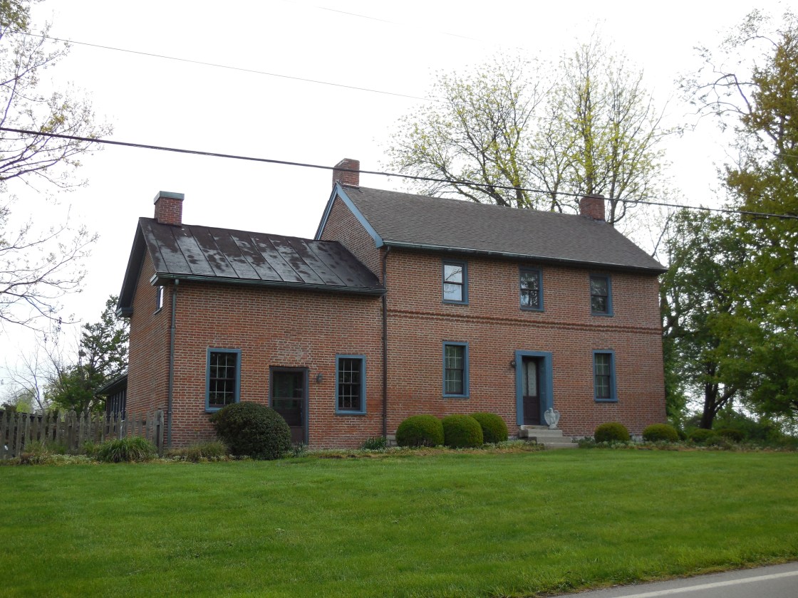
Description: Manor was along the Cincinnati, Lebanon, & Northern Railway in the late 1800s to early 1900s. The former track path can still be seen on satellite maps just west of the GPS coordinates. However, the most interesting remnant that still exists is a house that was constructed well before the town was founded. Robert Bradford (1788 – 1877) from Ireland and Elizabeth (Myers) Bradford (1797 – 1844) from Virginia were its original owners. Robert arrived in the U.S. in 1812. He was a weaver by trade and worked in a flour mill in Cincinnati for 3 years before moving to Montgomery County to follow agricultural pursuits. Robert and Elizabeth got married in 1817 and had 10 children. After living in a log cabin for a couple of decades, their stately brick house was completed in 1839. It was added to the National Register of Historic Places in 1979 and is reportedly haunted by the ghost of Elizabeth. According to county maps from the mid-1800s, it appears Robert sold the house shortly after Elizabeth passed away and moved to another location of his farm on the south side of E Social Row Rd. The Bradfords were buried with relatives in Sugar Creek Baptist Church Cemetery 4 1/2 miles northwest of the GPS coordinates on SR 48 (N Main St) in Centerville.
Pinchtown – Randolph and Madison Township
Location: 39.832952, -84.302735
on E Westbrook Rd between N Union Rd and SR 49 (Salem Ave)
Remnants: none known
Description: none found
Reesorville – City of Dayton (formerly in Harrison Township)
Location: 39.791167, -84.214344
on SR 48 (N Main St) at the intersection of Hillcrest Ave
Remnants: none known
Description: Its first cartographic appearance was on the 1869 county map. Reesorville was platted by Jacob Reasor (1828 – 1916) and Harriet (Rinehart) Reasor (1834 – 1918) and had a blacksmith shop, toll house, and a school. The town was annexed into Dayton before 1900. Jacob and Harriet were buried with relatives in Old Greencastle Cemetery on the east side of S Broadway St between Miami Chapel Rd and Noble Ave in Dayton.
Tadmor (Tadmer) – Butler Township, Montgomery County and Bethel Township, Miami County
Post Office: 1867 – 1917
Location: 39.89526, -84.165561
on hiking trails in Taylorsville Metropark along the Great Miami River
Remnants: historical marker, bridge abutments, and other stone remnants in Taylorsville Metropark
Description: Tadmor was founded on land owned by the Sutherland family and became a transportation hub as it sat at important crossroads next to the Miami & Erie Canal. It had two train stations. One of them was on the Cincinnati, Hamilton, & Dayton Railroad and another on the Dayton & Michigan Railroad with a general store and a grain elevator. The post office went by the name Tadmer from 1867 – 1884, then Tadmor from 1884 – 1917. Its first postmaster was Civil War veteran Captain Walter Crook (1824 – 1898). He was succeeded by German immigrant Peter Bohlender (1838 – 1914). They were both buried in Maple Hill Cemetery 4 1/2 miles north of the GPS coordinates on the east side of S Tipp Cowlesville Rd (S Hyatt St) in Tipp City. The next postmaster was John E. Shanck (1863 – 1953) and his wife Sarah Ellen (Benham) Shanck (1859 – 1949) was the last known postmaster. They were laid to rest in Union Cemetery on Olentangy River Rd in Columbus. Most of the town’s residents already moved north to the National Road (US 40) a few years before The Great Flood of 1913, which destroyed almost everything that was left of Tadmor. It was completely abandoned by 1922. There are several other old cemeteries in the area where the citizens of Tadmor were buried and some remnants of the town on the hiking trails in Taylorsville Metropark off of the Great Miami River Recreational Trail.
Wiggins
Location: unknown
Description: It was founded by a branch of the Wiggins family in the county.
Browns Chapel, OH (Browns Run) – (1801 – present farming town with less residents now than in the past)
Classification: small town
Location: German Township, Montgomery County – On Browns Run Rd near the intersection of Oxford Rd
It was first settled in 1798 by Richard Brown who was a fur trader and farmer. The town was surveyed in 1801 and grew with a couple of schools, a church, wool mill, and some of the local farmers also did other things like blacksmith work and carpentry. Browns Run was never a large town but had a post office from 1894 – 1899 and was widely known to be some of the best farming land in Montgomery County alongside Browns Run Creek. Roads in the early days were rough and hard to pass through, to say the least, but construction in the 1900s made travel a lot easier.
The area still keeps its name today, partly due to Brown’s Run Country Club which is a private membership golf course that opened in 1956 with the promise of playing the game in a more natural setting. Richard Brown was probably buried in Brown Run Cemetery with other early settlers and families.
Germantown, OH – (1804 – present farming, mill town, and railroad town)
Location: German Township, Montgomery County – On State Route 725
Classification: historic town
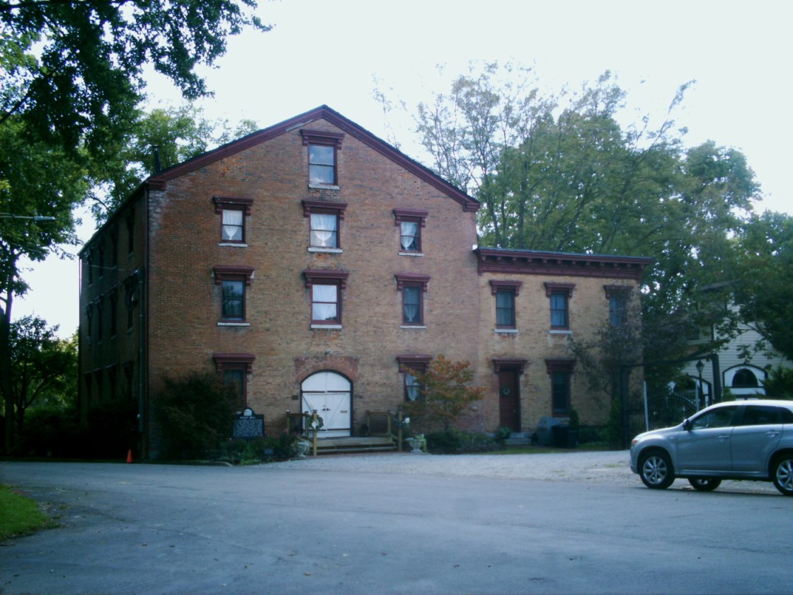
Settlers with German ancestry from Berks County, Pennsylvania begn making their way to the vicinity in the first few years of the 1800s. Philip Gunckel (1766-1848) and Catharine (Shaeffer) Gunckel (1766-1836) led a group of 24 families by flatboat to Cincinnati, and then up to Hole’s Station, later named Miamisburg. Philip was the only one who could speak English at the time. The Gunckels made a land speculation investment by buying up a bunch of the original lot recordings in the valley between Little Twin Creek and Big Twin Creek, founding Germantown in 1804. They had 8 children and Philip was a miller.
In 1806 the Guckels built a saw mill and grist mill on their land. They platted Germantown in 1814 with the main street leading from the mill into the village. The mill was sold to the Gunckels son-in-law Lewis Shuey in 1930. He rebuilt and enlarged the mill to three and a half stories in 1845. A cigar manufacturing plant bought the mill in 1888 and also used it for a tobacco warehouse. Around that time, a two-story addition was attached to the right side of the building. It’s presently operated as the Shuey Mill Inn & Event Center at 313 and is available for weddings and large events.
The Florentine Hotel at 21 W Market Street (State Route 725) started out as a brick structure that was completed in 1816. It’s currently the back portion of the former stagecoach stop and tavern. Two wood frame sections were added before 1860. Food was cooked for guests in the basement fireplace and traveled by dumb-waiter up to the restaurant on the first floor. The hotel had a few different names and 43 owners over the course of its life. It closed in 1974 while needing a lot of repairs. Two couples purchased it in 1976 and reopened the old hotel as a restaurant in 1979.
As with all of the historic towns in this book, I list many of the main attractions but also leave some surprises to be found by anyone who goes to explore them. After going to an intended destination, cruising around aimlessly and hitting the side streets in Ohio’s old towns usually leads to neat places you didn’t expect to run into. For me on this trip, it was Engine House Tattoo on E Center Street. The former firehouse was built in 1858 after the original one was destroyed in a fire. It was restored in 1996 and has been the tattoo shop since 2012.
In 1976 the area around the Florentine Hotel was added to the National Register of Historic Places as Guckel’s Town Plan Historic District. Germantown had a train station on the Cincinnati, Jackson, & Mackinaw Railroad. The station was built in 1896 and has been restored. It sits with a small length of tracks next to W Warren Street in Veterans Memorial Park. Philip and Catharine Gunckel were buried with relatives in Germantown Cemetery on State Route 725 west of town. Heading further into the outskirts of town, State Road United Methodist Church was built in 1920. The church and cemetery behind it are on land that was donated by relatives of Catharine Gunckel.
Old Dutch (Moyer) Cemetery is a mile west of the church on the south side of State Route 725. It dates back to 1820s and is named after the Moyer family who owned much of the land in the area. Some of their ancestors arrived in Germantown with the Gunckels. Moyer Road around the corner from the cemetery is also named after them. The cemetery has about 100 interments. It was once overgrown but is now preserved with a chain link fence and a historical marker. The burial ground looked nicely mowed and all of the stones appeared to be in their rightful places.

