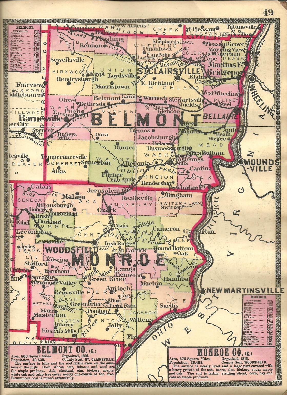
Cochransville (Cochrans Landing) (Center View) (Centerview) – Jackson Township
Post Office: 1846 – 1905
Location: 39.547143, -81.032037
on Township Hwy 532 along the Ohio River south off of SR 7 (Ohio River Scenic Byway)
Remnants: former plat roads, Carson (Cochransville) Cemetery on the north side of SR 7 about 3/4 of a mile northwest of the GPS coordinates, old houses and farm buildings in the area
Description: The town was platted in 1846 by Thomas Cochran Jr. (1799 – 1864) and Mary Ann (McEldowney) Cochran (1804 – 1883). They got married in 1828 and had a few children. The post office was originally called Cochran’s Landing from 1846 – 1858. It went by Centre View from 1858 – 1893, then Center View from 1893 – 1894, and lastly Centerview from 1894 – 1905. That name came from its position in the middle of a 20 mile straight stretch of the river. The known postmasters over the years were Robert S. Anderson, William H. Crump, Charles H. Kline, Charles A. Kline, M. Hall, E. D. Ames, Louis D. Heinlein, John W. Hutchison, Samuel Hutchison, and A. L. Stansbury. Part of the plat outline of Cochransville can still be seen on satellite maps. It contained 44 lots in the 1898 county atlas. At that time the town had a mill, school, and a Methodist Episcopal church. Thomas and Mary were buried with relatives in Carson (Cochransville) Cemetery across the border in Grandview Township, Washington County. As with many ghost town and current towns in Ohio, the founding families and prominent landowners intermarried. One of the Cochran daughters, Elizabeth (1831 – 1858), married Joseph Witten (1830 – 1918). The nearby town of Wittens had a post office from 1833 – 1907. Elizabeth was also laid to rest in Carson Cemetery. Joseph was buried with relatives in Witten Cemetery 5 miles northeast of the GPS coordinates on River St. Carson Cemetery is on land that was owned by William Carson (1833 – 1924) and Elizabeth (Jolly) Carson (1828 – 1884). Brownsville in Benton Township had a post office called Jolly from 1842 – 1916. Friendly, West Virginia, across the Ohio River from Cochransville was founded by Friend Cochran Williamson (1838 – 1908) who was also related to the Cochrans.
Cross Keys (Crosskeys) – Bethel Township
Post Office: 1893 – 1914
Location: 39.589350, -81.230124
on Hopewell Ridge Rd (Co Rd 105) between Beardmore Rd and T64
Remnants: Hopewell Cemetery on the north side of Hopewell Ridge Rd east of the GPS coordinates
Description: Cross Keys had a Methodist Episcopal church at Hopwell cemetery on land donated by Seth Adams (1849 – 1876) and Mary Jane (Humphrey) Adams Betts. They got married in 1869 and had a few children. Seth died at 26 years of age and Mary Jane later remarried. The town also had a school 1 mile southeast of the GPS coordinates on the southwest side of Hopewell Ridge Rd near the intersection of T64. It was on land owned by Reverend Anson Roach (1842 – 1909) and Preshia (Edwards) Roach (1850 – 1938). Anson and Preshia were buried with relatives in Moose Ridge Cemetery on Moose Ridge Rd in Center Township. The known postmasters were A. H. Roach and Henry C. Parker.
Fair Pleasant (Van Buren)
Post Office: 1839 – 1842
Location: unknown
Description: In December of 1839, a Mr. Johnson introduced notice of a bill to change the town name of Van Buren to Fair Pleasant at a meeting of the Ohio House Of Representatives. The bill was ratified and the act was passed on January, 20, 1840. George Gray Jr. was the only known postmaster. Fair Pleasant (Fairpleasant) was later listed in the 1843 A Table Of Post-Offices In Ohio as a discontinued office in the county. There were a couple of George Grays in the county during the time period in question who were recorded in the 1840 census, one living in Franklin Township and the other in Perry Township.
Hope Ridge – Center Township
Post Office: 1858 – 1872
Location: 39.790633, -81.123750
on SR 800 between Township Hwy 35 and Water Works Rd
Remnants: Hope Ridge Cemetery at the GPS coordinates, old houses and farm buildings in the area
Description: Hope Ridge was founded by Irish immigrants Reverend John Clingan (Clinghan) (1783 – 1858) and Mary (Armstrong) Clingan (1787 – 1865) who were early pioneers in the county. It had a Methodist Episcopal church at the cemetery and a couple of mills south of the GPS coordinates along Sunfish Creek. A school (Center Township No. 3) was about 3/4 of a mile north of the GPS coordinates on the east side of SR 800 near the intersection of Township Hwy 35. It closed in 1929 with Nellie (Turner) Jones (1908 – 1988) serving as the last teacher. She was laid to rest with relatives 2 miles south of the GPS coordinates in Oaklawn Cemetery on Oaklawn Ave in Woodsfield. The post office was across the road from the school on the south side of Township Hwy 35 near the intersection. William M. Preshaw (1825 – 1898) was the only known postmaster. He moved out of the state and was buried with relatives in Highland Cemetery at the intersectionof E 15th St and Montana Rd in Franklin County, Kansas. John and Mary had several children and were buried with relatives in Hope Ridge Cemetery. Some other big surnames from the area were Burkhead, Donnely, Ford, McFadden, Rouse, and Wittenbrook.
Jerles – Franklin Township
Post Office: 1884 – 1905
Location: 39.738563, -81.295296
on SR 145 at the 4-way intersection of SR 724 and Mallett Rd (Township Hwy 834)
Remnants: old houses and farm buildings in the area
Description: The proprietors were Thomas F. Jerles (1851 – 1935) and Mary (Swain) Jerles (1851 – 1924). Thomas was the town’s postmaster. The town had a school on the east side of Bean Ridge Rd about 1/2 of a mile north of the GPS coordinates on a 20-acre farm owned by the Wilhelm family. It was known as Knob, or Knob College, and closed in 1929 with Freda Reed (b. 1908) serving as the last teacher. She married David H. Sutton in 1940, but we have as of yet been unable to locate their gravestones. A church was on the east side of SR 145 about 1/3 of a mile north of the GPS coordinates on a 20-acre farm owned by the Wooley family. They can be found pinpointed in the 1898 county atlas. Thomas and Mary were buried with relatives in Greenwood Cemetery on W Spruce Ave in Byesville, Guernsey County.
Jonesville – Salem Township
Post Office: 1831 – 1855
Location: 39.749220, -80.920940
on Gibbs Rd (Township Rd 4) off of SR 78 along Sunfish Creek
Remnants: Zeisger Cemetery on the south side of SR 78 about 1 1/4 miles northeast of the GPS coordinates, Salem Church and Cemetery and St. James Lutheran Cemetery on Sykes Ridge Rd (County Hwy 4) south of Sunfish Creek
Description: Johnson L. Jones (1811 – 1893) from Virginia built a mill next to the creek on the west side of the GPS coordinates in the mid-1800s. He was married 3 times and had 12 children. Johnson moved around often and was buried with relatives in Powhatan Cemetery on SR 7 in Powhatan Point, Belmont County. The town had a school on the west side of Gibbs Rd about 1 mile northeast of the GPS coordinates. There were also 2 local schools and 3 churches along Sykes Ridge Rd. A road formerly crossed the creek near the GPS coordinates in the mid-1800s and headed south to Sykes Ridge Rd. The known postmasters were Willis P. Coleman, Daniel Clark, Johnson L. Jones, and Charles McGonigal.
Lecompton (Shannon) (Hamilton) – Summit Township
Post Office: 1839 – 1841 and 1858 – 1883
Location: 39.758651, -81.248296
on SR 145 at the 4-way intersection of Hanson Ridge Rd and Bracken Ridge Rd
Remnants: Hamilton Cemetery about 2 1/4 miles north of the intersection on private property on the north side of DeVoe Rd (Township Rd 71), Wise Cemetery 1 1/2 miles north of the intersection on the east side of SR 78, Bracken Ridge Church Cemetery 1 1/2 miles northwest of the GPS coordinates at the intersection of Bracken Ridge Rd and Township Hwy 241
Lecompton was originally called Shannon. Daniel Todd was the only known postmaster of the Shannon office from 1839 – 1841. The town had a school in the mid-1800s on the west side of Bracken Ridge Rd about 1/2 of a mile northwest of the GPS coordinates on land owned by Jacob H. Hamilton (1817 – 1895) from Greene County, Pennsylvania and Maria (Robison) Hamilton (1817 – 1864) from Ireland. Jacob was the postmaster of the Lecompton office, a township trustee, and a land appraiser. The school was replaced by a newer one, Summit Township No. 6, at the same location in the later 1800s. During that time, the land was owned by Margaret (Hamilton) Wagonfield (1842 – 1932), a daughter of Jacob and Maria. Jacob’s parents, John Hamilton (1794 – 1854) and Margaret (Wise) Hamilton (1797 – 1870), were early county pioneers and buried with relatives in Hamilton Cemetery. They were laid to rest in Buchanan Presbyterian Church Cemetery 4 1/2 miles west of the GPS coordinates at the intersection of SR 78 and Township Hwy 51. A Methodist Episcopal church was on the west side of SR 78 across from Wise Cemetery. They were on land owned by Civil War veteran Samuel D. Wise (1835 – 1907) and Elizabeth (Clegg) Wise (1835 – 1912) who were buried with relatives in Bracken Ridge Church Cemetery. Lecompton was passed up by the Bellaire, Zanesville, & Cincinnati Railroad and couldn’t compete with nearby Lewisville, which had faster growth and was rewarded with a train station. It currently goes by the name of Hamilton as a populated place.
Lyman – Perry and Green Township
Post Office: 1901 – 1903
Location: 39.660948, -81.015237
on West Union Rd at the 4-way intersection of Co Rd 67 and Township Rd 506 along the Little Muskingum River
Remnants: West Union Church and Cemetery on the south side of West Union Rd just east of the GPS coordinates, old houses and farm buildings in the area
Description: It was named after the Lyman family in the area and had a one-room schoolhouse built by Benjamin K. Starkey (1859 – 1935). He was buried with relatives in Antioch Cemetery 3 3/4 miles west of the GPS coordinates on the west side of SR 800. The post office didn’t last long, but Lyman was a town well before and well after it was in operation. Many residents were buried in West Union Cemetery.
Pryor (Ethel) – Seneca Township
Post Office: 1883 – 1929
Location: 39.790171, -81.304523
on SR 78 at the intersection of Swazey Rd
Remnants: old houses and farm buildings in the area
Description: The town was on the Bellaire, Zanesville, & Cincinnati Railroad (later the Ohio River & Western Railroad). Its general store also served as the train station. Hiram H. Gibson (1859 – 1929) was the first proprietor and postmaster. He married Martha (Williams) Gibson (1855 – 1942) in 1883, moved out of the county, and was buried with relatives in Friends Cemetery on the north side of SR 265 (Leatherwood Rd) in Quaker City, Guernsey County. Eber H. Pryor (1858 – 1931) was the last known proprietor and postmaster. He married Isophene (Baker) Pryor (1857 – 1950) in 1890 and was laid to rest with relatives 2 1/2 miles northwest of the GPS coordinates in Eastern Cemetery on the east side of SR 513 in Summerfield, Noble County. There was also a school (Seneca Township No. 4) about 1 mile northeast of the GPS coordinates on the south side of Bracken Ridge Rd on a 158-acre farm owned by Joseph M. Carpenter (1828 – 1899) and Matilda (Arick) Carpenter (1833 – 1916). They were laid to rest with relatives 3 1/2 miles southeast of the GPS coordinates in Bracken Ridge Church Cemetery at the intersection of Bracken Ridge Rd and Township Hwy 241.
Quarry – Bethel Township
Post Office: 1880 – 1912
Location: 39.591096, -81.220646
on SR 260 between Witten Creek Rd and Hopewell Ridge Rd
Remnants: none known
Description: Quarry was founded by John S. Hall (1839 – 1914) and Margaret Hall (1846 – 1914). They operated a general store and the post office on the east side of SR 260 close to the GPS coordinates. The other known postmasters were John and Margaret were buried with relatives in Hopwell Cemetery 1 3/4 miles south of the GPS coordinates on Hopewell Ridge Rd. John W. Speece (1887 – 1966) was the only other known postmaster. He married Mary (Williamson) Speece (1888 – 1970). They were laid to rest in Rockland Cemetery on the south side of SR 7 in Belpre Township, Washington County.
Clarington, OH – (1822 – present farm and river town slowly abandoned over time)
Classification: small town
Location: Salem Township, Monroe County – On SR 7 at the intersection of SR 78
David Pierson opened a grocery store in the area in 1815. Later in 1822, he bought more land from William Henthorn and decided to name a town after his daughter, Clarinda Peirson. A post office was established in 1824 and the town had around 1,000 residents in the 1890s, but the population has been declining since then. It was at 384 in the 2010 census. The Ohio Valley River Museum is at 112 Ferry St.
Museum Info – http://www.ohio.org/destination/art-museums-and-galleries/ohio-valley-river-museum