
Babbtown (Fairmount) (Fair Mount) – Bethel Township
Post Office: 1846 – 1857
Location: 39.970314, -84.139422
on SR 202 along Honey Creek between SR 571 and Tipp – Elizabeth Rd
Remnants: Kepper (Old Jackson) Cemetery on the west side of SR 202 with an access road north of the GPS coordinates
Description: It was founded by Daniel Babb (1799 – 1881) from Pennsylvania and Leah (Littler) Babb (1804 – 1872) from Virginia. They got married in 1823, had 8 children, and purchased a grist mill next to Honey Creek in 1831. The mill was constructed in 1815 by David Staley (1791 – 1862) from Maryland. Daniel and Leah also owned a general store, cooper shop, and blacksmith shop. There was a post office in the store called Fairmount, with Daniel holding the postmaster position, but residents affectionately called the village Babbtown. Daniel closed the mill in 1873 and the town didn’t make it into the 1900s. The Babbs and David Staley were buried with relatives in Kepper Cemetery.
Conquest
Post Office: 1839 – 1842
Location: unknown
Description: John Bowers was the postmaster.
County Line (Pigeye) – Union Township, Miami County and Randolph Township, Montgomery County
Location: 39.922841, -84.311900
on SR 48 (S Miami St) at the intersection of N Montgomery County Line Rd along Pigeye Creek
Remnants: none known
Description: County Line didn’t last long as a town, but it had a grist mill, saw mill, school, and a train station on the Cincinnati, Hamilton, & Dayton Railroad during its existence.
Ellemans – Newton and Union Township
Post Office: 1880 – 1883
Location: 40.008288, -84.339398
on SR 48 at the intersection of W Horseshoe Bend Rd along Rocky Run
Remnants: Union Joint (Old Union) Cemetery north of Horseshoe Bend Rd with an access road east of the GPS coordinates
Description: Ellemans was on the Cincinnati, Hamilton, & Dayton Railroad. The proprietors were Thomas Elleman (1841 – 1925) and Martha (Jay) Elleman (1839 – 1893), both born in Miami County. They were married in 1858 and had 9 children. Thomas was the town’s postmaster. Martha’s paternal grandmother was a member of the Coppock family who owned much of the land in the area, including the cemetery lot which also had a church. Thomas and Martha were buried with relatives in Union Joint Cemetery.
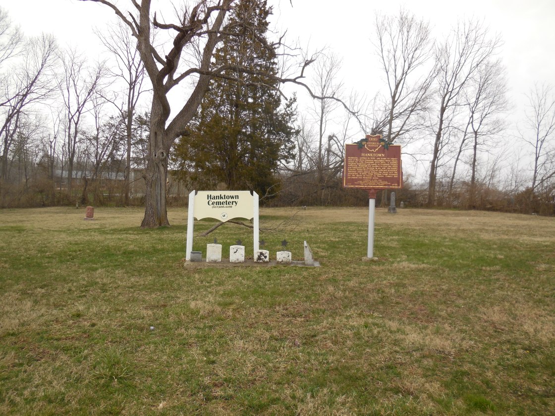
Hanktown (Randolph) (Randolph Settlement) – Union Township
Location: 39.987659, -84.381850
on SR 571 between S Shiloh Rd and S Range Line Rd
Remnants: Hanktown Cemetery on the north side of SR 571 at the GPS coordinates, historical marker at the cemetery
Description: John Randolph (1773 – 1833) was a cousin of 3rd U.S. President Thomas Jefferson and owned a plantation in Virginia with plans to free its slaves. According to the 1900 county history book, John inherited the slaves from his father and never bought or sold them. John opposed slavery, but it basically would have been a suicidal act to free them in Virginia during his lifetime. After 13 years of sorting out John’s many wills in court, the freed slaves made the journey to Ohio in 1846. There were 383 in total and 89 of them settled in Miami County on 200 acres of land surrounding the GPS coordinates. Most of the others went to Mercer, Shelby, and Van Wert County prior to the Civil War. A school was pinpointed on the south side of SR 571 across from the cemetery on the 1858 county map. Hanktown Baptist Church was built on the north side of SR 571 next to the cemetery prior to publication of the 1871 county atlas. The settlement’s 200-acre farm had been divided up into separate lots of ownership by then. Among the town’s residents, 7 of them joined the Union Army during the Civil War.
Jimtown – Washington Township
Location: 40.111033, -84.278094
on Stillwell Rd at the intersection of Bausman Rd
Remnants: Gangloff house in the northwest lot of the intersection
Description: Jimtown’s main industry was farming. It had a school in the southeast corner of the intersection. Felix Gangloff (1861 – 1950) and Theresa (Antauer) Gangloff (1895 – 1941) owned the now abandoned house in the farm field in the northwest lot of the intersection. Felix was a son of German immigrants and Theresa moved to Ohio from Austria with her parents. They were married in 1917 and had a daughter. The family was buried in Forest Hill Cemetery about 5 miles northeast of the GPS coordinates on SR 66 on the north side of Piqua.
Jordans – Springcreek Township
Location: unknown
Description: It was between Piqua and Fletcher on the Pittsburgh, Cincinnati, Chicago, & St. Louis Railroad (Panhandle Route) and was named after a branch of the Jordan family in the township.
Meyers – Washington and Newberry Township
Location: 40.131063, -84.316984
on Newberry – Washington South Rd at the former railroad crossing between US 36 and Piqua – Clayton Rd
Remnants: none known
Description: Meyers was between Covington and Piqua on the Pittsburgh, Cincinnati, Chicago, & St. Louis Railroad (Panhandle Route. Its proprietors were Joseph Myers (1848 – 1934) and Mary (Brinkman) Myers (1853 – 1919). They were buried with relatives about 3 miles west of town in Highland (Covington) Cemetery at the intersection of SR 48 and W Ingle Rd on the north side of Covington.
Petersons (Petersons Station) – Staunton Township
Post Office: 1855 – 1860
Location: 40.107213, -84.213985
on W Peterson Rd at the railroad crossing between Piqua – Troy Rd and Troy – Sidney Rd
Remnants: none known
Description: It was founded by Ralph Peterson (1800 – 1888) and Sarah (Hardenbrook) Peterson (1803 – 1888). They got married in 1822, settled in Miami County in 1827, and had 11 children. Like many early pioneering families, the Petersons lived in a log cabin until they could afford to build a frame house after continually clearing and improving their 160-acre farm. Ralph also served as county commissioner. The town was on the Dayton & Michigan Railroad (later the Cincinnati, Hamilton, & Dayton) and had a train station and warehouse on the north side of W Peterson Rd at the GPS coordinates. A school was on the east side of Orbison Rd on land owned by the Willard family. Ralph and Sarah were buried with relatives about 3 miles south of town in Raper Chapel Cemetery on the west side of Troy – Piqua Rd.
Rag Town (Ragtown) – Elizabeth Township
Location: 40.001021, -84.124970
on Walnut Grove – Clark County Rd at the intersection of S Rudy Rd along Pleasant Run
Remnants: Martin (Hart) (Walnut Grove) Cemetery on the north side of Walnut Grove – Clark County Rd west of the GPS coordinates
Description: Rag Town was named after its wool factory whose main product was cloth rags. Henry Carver (1816 – 1890) and Permilia (Knoop) Carver (1819 – 1904) were the last owners of the mill. They were married in 1843, had 6 children, and a 423-acre farm. The town also had a school in a farm field northwest of the cemetery and a saw mill next to Pleasant Run north of the wool mill owned by Irish immigrants Robert Sproul (1775 – 1858) and Isabella (Haynes) Sproul (1782 – 1859). They had 12 children and were buried with relatives in Casstown Cemetery north of the GPS coordinates at the intersection of N Children’s Home Rd and McCandliss Rd. Henry and Permilia Carver were buried with relatives in Riverside Cemetery on Riverside Dr in Troy. Most of the town’s residents were buried in Martin Cemetery.
Rangeville – Newberry Township
Location: 40.181215, -84.394498
on Versailles Rd (Co Hwy 28) at the intersection of Frankman Rd
Remnants: Friedens Lutheran Church and Cemetery 1 mile west of the GPS coordinates on the south side of Versailles Rd, old houses and farm buildings in the area
Description: Rangeville was on the Cincinnati, Hamilton, & Dayton Railroad and had a school (Newberry Township No. 5) on the south side of Versailles Rd east of the GPS coordinates. The Routson and Apple families were the most influential in Rangeville and still have descendants living in the area. Many of their members were buried in Friedens Cemetery.
Sodom – Lostcreek Township
Location: 40.087491, -84.070800
on Troy Urbana Rd (Co Hwy 193) at the intersection of Sodom Rd
Remnants: Lost Creek United Church at the intersection, Sodom Cemetery behind the church
Description: Sodom had a school and a shingle factory on the north side of Troy Urbana Rd west of the GPS coordinates on land owned by the Long family. James Pence (1821 – 1883) from Warren County and Nancy (Shidler) Pence (1820 – 1908) from Pennsylvania owned a blacksmith shop at the southwest corner of the intersection and donated land for the church. They were married in 1841, had 8 children, and a large farm. James and Nancy were buried with relatives 7 miles northwest of town in Fletcher Cemetery on Church St (Casstown – Fletcher Rd) just north of US 36.
Summitville – Newberry Township
Location: 40.161378, -84.327057
on SR 185 at the intersection of Mulberry Grove – Rakestraw Rd (Co Hwy 32)
Remnants: former one-room schoolhouse at the intersection of SR 185 and N McMaken Rd
Description: There wasn’t much to this small farming town besides the school (Newberry Township No. 12) which is currently a private residence. The land for it was donated by Henry Rike (1821 – 1883). He was buried with relatives in Davids Cemetery on Mad River Rd in Kettering, Montgomery County.
Tadmor (Tadmer) – Bethel Township, Miami County and Butler Township, Montgomery County
Post Office: 1867 – 1917
Location: 39.89526, -84.165561
on hiking trails in Taylorsville Metropark along the Great Miami River
Remnants: historical marker, bridge abutments, and other stone remnants in Taylorsville Metropark
Description: Tadmor was founded on land owned by the Sutherland family and became a transportation hub as it sat at important crossroads next to the Miami & Erie Canal. It had two train stations. One of them was on the Cincinnati, Hamilton, & Dayton Railroad and another on the Dayton & Michigan Railroad with a general store and a grain elevator. The post office went by the name Tadmer from 1867 – 1884, then Tadmor from 1884 – 1917. Its first postmaster was Civil War veteran Captain Walter Crook (1824 – 1898). He was succeeded by German immigrant Peter Bohlender (1838 – 1914). They were both buried in Maple Hill Cemetery 4 1/2 miles north of the GPS coordinates on the east side of S Tipp Cowlesville Rd (S Hyatt St) in Tipp City. The next postmaster was John E. Shanck (1863 – 1953) and his wife Sarah Ellen (Benham) Shanck (1859 – 1949) was the last known postmaster. They were laid to rest in Union Cemetery on Olentangy River Rd in Columbus. Most of the town’s residents already moved north to the National Road (US 40) a few years before The Great Flood of 1913, which destroyed almost everything that was left of Tadmor. It was completely abandoned by 1922. There are several other old cemeteries in the area where the citizens of Tadmor were buried and some remnants of the town on the hiking trails in Taylorsville Metropark off of the Great Miami River Recreational Trail.
Twin Lakes – Springcreek and Staunton Township
Location: 40.121749, -84.214627
on W Loy Rd between I-75 and Free Rd
Remnants: old houses and farm buildings in the area
Description: The proprietors were John Loy (1821 – 1910) from Butler County and Cynthia (Buckles) Loy (1831 – 1921). They had 9 children and a 160-acre farm. John was a carpenter and contractor. A natural spring on the Loy farm was used to create 2 lakes for stocked fish ponds, hence the town’s name. They were on the southern half of the Loy farm and can be spotted in the 1911 county atlas. Although the Cincinnati, Hamilton, & Dayton Railroad rolled through the area, it didn’t add much to the stature of Twin Lakes. John and Cynthia were buried with relatives in Forest Hill Cemetery about 6 miles northwest of town on SR 66 on the north side of Piqua.
Winans Station – Staunton Township
Location: 40.079515, -84.205802
on Piqua – Troy Rd at the intersection of Eldean Rd
Remnants: Raper Chapel Cemetery on the west side of Piqua – Troy Rd south of the GPS coordinates
Description: It was founded by Richard Winans (1781 – 1863) and Sarah (Ross) Winans (1788 – 1858). They were married in 1807 and moved to Ohio from New Jersey later that same year. The relocation of their lives took 41 days. It started with an ox team and wagon from New Jersey to Wheeling, West Virginia. From there, they went by flatboat on the Ohio River to Cincinnati, and back in the ox wagon up to the newly formed Miami County. The town had a train station on the Dayton & Michigan Railroad (later the Cincinnati, Hamilton, & Dayton) and a church. Richard and Sarah were buried with relatives in Raper Chapel Cemetery.

