
Boetia – Center and Hopewell Township
Post Office: 1850 – 1865
Location: 40.611437, -84.570915
on US 127 at the intersection of Oregon Rd
Remnants: Roberts Cemetery on the north side of Oregon Rd about 1/3 of a mile east of the GPS coordinates
Description: Boetia was a small farming and postal town. The known postmasters were J. P. Wood, John Roberts (1829 – 1874), and Civil War veteran Peter W. Shimp (1816 – 1893). John married Harriet (Hainline) Roberts (1829 – 1856) and owned the 79-acre farm at Roberts Cemetery which now consists of a mostly wooded lot along Blierdofer Ditch. His parents, Joshua Roberts (1796 – 1892) from Virginia and Elizabeth (Beaghler) Roberts (1794 – 1874) from Pennsylvania were early pioneers in the county. Peter W. Shimp owned an 80-acre farm on the southwest side of the GPS coordinates. He was born in Fairfield County, married Christina (Raudabaugh) Shimp (d. 1865) in 1840, and had 7 children. They moved to Mercer County in 1857. We were unable to locate any info on J. P. Wood, but everyone else mentioned in this listing was laid to rest with relatives in Roberts Cemetery.
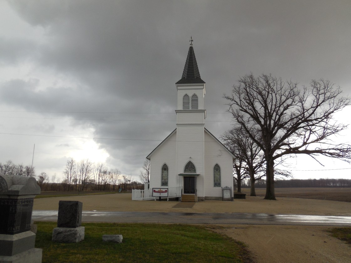
Brehm – Liberty Township
Post Office: 1890 – 1897
Location: 40.622501, -84.746880
on Wabash Rd along Black Creek between Schaadt Rd and Oregon Rd
Remnants: St. Paul’s Lutheran Church and Cemetery at the GPS coordinates, former church building in St. Paul’s Lutheran Cemetery, St. Paul’s United Church of Christ Cemetery about 3/4 of a mile south of the GPS coordinates at the intersection of Wabash Rd and Oregon Rd
Description: German immigrant John Brehm (1828 – 1907) arrived in the U.S. around 1848 with a fine education and a few years of being a skilled baker. He originally settled in Montgomery County, turned into a self-taught farmer, and had 8 children with his first wife Mary (Lower) Brehm. John remarried after Mary passed away and had 3 more children with Margaretha Johanna (Bollenbacher) Brehm (1833 – 1897). John and Margaretha moved their family to a recently purchased 100-acre farm in Mercer County in 1872 where many other German immigrants were already living. A one-room schoolhouse (Liberty Township No. 2) was in the northwest the corner of the intersection of Wabash Rd and Schaadt Rd. Philip Kable Sr. (1850 – 1915) was the town’s postmaster and was buried with relatives and other residents in St. Paul’s Lutheran Church Cemetery. The congregation formed in 1841 and its first church building was completed in 1850 next to the cemetery. It is still standing and has had a nice restoration. The Brehms donated land and funds for the present St. Paul’s Evangelical Lutheran Church across the road. Its congregation and the church are still active, having celebrated their 175th anniversary in 2016. John and Margaretha were buried in St. Paul’s United Church of Christ Cemetery at the intersection of Wabash Rd and Oregon Rd with many relatives.
Byrds (Birds Station) – Union Township, Mercer County and Jennings Township, Van Wert County
Location: 40.688293, -84.456149
on Mercer Van Wert County Line Rd between Shelley Rd and Deep Cut Rd
Remnants: none known
Description: James Bird donated land for a train station on the Toledo, Cincinnati, & St. Louis Railroad (later the Cincinnati, Hamilton, & Dayton Railroad) on his 31-acre farm on the southwest side of the GPS coordinates in the late 1800s. Joseph Bird owned the land when the 1900 county atlas was published. The railroad tracks are long gone and the former track bed is only faintly visibly discernible on satellite maps these days.
Coil Town (Coiltown) – Union Township
Location: unknown
Description: It was platted in 1823 by Andrew Coil (1770 – 1845) from Augusta County, Virginia who hoped the town would become the future county seat. The lots didn’t sell well and in 1824 the county seat was moved from Shanesville (Rockford) to St. Marys which is now in Auglaize County. As a result, Coil Town rapidly faded into oblivion. Andrew had 12 children, 6 with Frances (Conrad) Coil (1768 – 1824) and 6 with Elizabeth (Foster) Coil (died c. 1850). The children were very successful in Union Township and the area around Mendon. Andrew passed away in Fayette County and his burial location is unknown. However, over 140 of Andrew’s descendants are interred there, including some in Coil Cemetery on the north side of Palmer Rd NW on the northwest side of Washington Court House. The location of Coil Town also couldn’t be pinpointed. Andrew’s original cabin in Mercer County, built in 1822 with his son-in-law Thomas Parrott (1798 – 1880), was along Twelvemile Creek in southern Union Township. It’s also unknown if Andrew moved from that farm before platting the town. Coil Rd northeast of Mendon was likely named after the family of Andrew Coil (1842 – 1917) and Barbara (Spicer) Coil (1845 – 1917) who owned a 118-acre farm in the southeast corner of the intersection of Coil Rd and Shelley Rd. They were buried with relatives in Mendon Cemetery at the intersection of SR 707 and Hamilton Rd.
Earley (Oregon Station) – Hopewell Township
Post Office: 1881 – 1912
Location: 40.611405, -84.590160
on Oregon Rd at the intersection with Weitz Rd along Twelvemile Creek
Remnants: Union Cemetery on the north side of Oregon Rd about 1/2 of a mile west of the GPS coordinates, Roberts Cemetery on the north side of Oregon Rd 1 1/2 miles east of the GPS coordinates
Description: Oregon Station was originally on the Toledo, Cincinnati, & St. Louis Railroad (later the Cincinnati, Hamilton, & Dayton Railroad). Its general store and post office called Earley was in the southeast corner of the intersection along with a tile mill on a 79-acre farm owned by Samuel Brookhart (1829 – 1916) and Mary Ann (Sinift) Brookhart (1830 – 1894) from Fairfield County. They had 7 children and were buried with relatives in Roberts Cemetery. Daniel Weaver (1827 – 1908) and Elizabeth (Crider) Weaver (1828 – 1902) owned a blacksmith shop on their 79-acre farm in the southwest corner of the intersection and had at least 10 children. They were laid to rest with relatives and other residents in Union Cemetery. The town also had a United Brethren Church at Union Cemetery and 2 local schools. Hopewell Township No. 1 was a mile north of the GPS coordinates on the north side of Fast Rd and Hopewell Township No. 5 was a mile south of the GPS coordinates in the northeast corner of the intersection of Weitz Rd and Morrow Rd. Jacob C. Brookhart (1843 – 1820), a nephew of Samuel and Mary Ann, and Sarah (Upton) Brookhart (1840 – 1923) owned a cider mill along Twelvemile Creek on their 160-acre farm just southeast of the Hopewell Township No. 1 school. They had a few children and were buried with relatives in North Grove Cemetery 4 1/2 miles southeast of the GPS coordinates on US 127 (N Main St) in Celina. James L. Morrow (1858 – 1930) and Della (Weaver) Morrow (1865 – 1953) owned a steam-powered saw mill and later a tile mill on the north side of Twelvemile Creek about 3/4 of a mile southwest of the GPS coordinates on the west side of Hoenie Rd. They had at least 9 children and were laid to rest with relatives in North Grove Cemetery. The known postmasters were C. L. Bader, J. L. Crider, James Weaver, and Charles S. Johnson.
Marcellus
Post Office: 1858 – 1861
Location: unknown
Description: The proprietor and postmaster James W. Carlin (1832 – 1865) from Wayne County married Elizabeth (Stuck) Carlin (1834 – 1899) from Pennsylvania. James joined the 71st Ohio Volunteer Infantry and achieved the rank of major in the Civil War. He died on the steamboat “Sultana” which sank when 3 of its 4 boilers exploded near Memphis, Tennessee on April 27, 1865. It was the worst maritime disaster in U.S. history. The ship was designed to accommodate 376 passengers. That number was disregarded during the war to help with transporting troops, including many who were released from Confederate prison camps. James was captured by Confederate soldiers in Alabama in 1864 and was incarcerated in Camp Sumter’s Andersonville Prison in Georgia. The “Sultana” was carrying 2,137 passengers at the time of the disaster. Various death toll estimates ranged from 1,100 to 1,568. James had 3 children and was laid to rest with Elizabeth and other relatives in North Grove Cemetery on US 127 (N Main St) in Celina.
Reservoir (Reservoir Station) – Jefferson Township
Post Office: 1856 – 1884
Location: 40.553277, -84.493913
on Riley Rd at the railroad crossing between SR 29 and SR 703
Remnants: none known
Description: Reservoir was on the Lake Erie & Western Railroad on the north side of Grand Lake. The first postmaster was Dr. Milton M. Miller (1819 – 1889). He was succeeded by Calvin E. Riley (1830 – 1914) who owned most of the land surrounding the GPS coordinates in the late 1800s to early 1900s. Calvin married Gabrilla (Brandon) Riley (b. 1833) in 1854 and had 7 children. They moved from Celina to what was then called Lake Mercer in 1862, enjoying the change of living in a rural lakeside environment. Calvin held the postmaster position from that year until the office was discontinued. There were 2 local schools. Jefferson Township No. 1 was a mile east of the GPS coordinates in the southwest corner of the railroad tracks at 4 Turkey Rd. Jefferson Township No. 2 was about 3/4 of a mile southwest of the GPS coordinates in the lot in the northwest corner of SR 703 and Emerson Rd. Everyone mentioned in this listing was interred in North Grove Cemetery about 5 miles northwest of the GPS coordinates on US 127 (N Main St) in Celina.
Steinman (Steineman Station) – Marion Township
Location: 40.365562, -84.493754
on SR 716 at the intersection of Indian Trail Rd
Remnants: none known
Description: It was founded by the Steinman (Steineman / Stineman) family in the area who owned over 600 acres of farmland on the southeast side of the GPS coordinates in the late 1800s. The town had a steam-powered saw mill on a 100-acre farm in the northwest corner of the intersection, a few local schools, and a train station on the Toledo, Cincinnati, & St. Louis Railroad (later the Cincinnati, Hamilton, & Dayton Railroad). Most of the area’s residents were of German descent.
Striptown – Liberty and Hopewell Township
Location: 40.589325, -84.689248
on Township Line Rd at the intersection of Scleucher Rd along Prairie Creek
Remnants: former one-room schoolhouse 1 1/2 miles northwest of the GPS coordinates in the norhteast corner of the intersection of Erastus Durbin Rd and Frahm Pike, old houses amd farm buildings in the area
Description: The origin of Striptown’s name is a mystery. There were 2 local schools. Hopewell Township No. 8 was 1 1/4 miles east of the GPS coordinates in the northeast corner of the intersection of Scleucher Rd and Now Rd on a farm owned by the Pearstorff family. Liberty Township No. 6 at the intersection of Erastus Durbin Rd and Frahm Pike was on an 80-acre farm owned by Elias Howell (1842 – 1924) and Sarah (Watkins) Howell (1841 – 1905). They were laid to rest with relatives in Hodge Cemetery on the west side of T-23 in Bloomfield Township, Logan County. The school was converted into a makeshift barn in the mid-1900s and isn’t in great shape. A church called Landfair was across from the school on the west side of Erastus Durbin Rd and a small cemetery lines the roadside.

