
Barnard
Location: unknown
Description: Barnard was listed as a post township in the 1819 The Ohio Gazetteer, Or, Topographical Dictionary.
Beech Grove – Salisbury Township
Post Office: 1861 – 1863
Location: 39.039382, -82.045277
on Mulberry Ave at the 4-way intersection of Hiland Rd, Mulberry Heights, and E Memorial Dr
Remnants: Beech Grove (Pomeroy) Cemetery on Mulberry Heights
Description: This mid-1800s crossroads town has since been annexed into Pomeroy, the seat of Meigs County.
Buckhorn – Rutland Township
Location: 39.073056, -82.202215
on Dexter Rd at the intersection of Jr Ward along Leading Creek
Remnants: none known
Description: Buckhorn was on the Toledo & Ohio Central Railroad between Dexter and Langsville but it didn’t have a train station.
Bunker Hill – Bedford and Salisbury Township
Location: 39.105856, -82.063140
on Ball Run Rd at the intersection of Bunker Hill Church Rd
Remnants: Bunker Hill Cemetery on the east side of Ball Run Rd south of the GPS coordinates, old houses and farm buildings in the area
Description: Bunker Hill Cemetery is still in use with burials as recent as 2016. The town’s former church was in the triangle shaped lot on the west side of the GPS coordinates.
Calvin
Location: unknown
Description: none found
Dillsbury – Chester Township
Location: unknown
Description: It was platted in the 1830s and was named after a branch of the Dill family in the county. The town was mentioned in The Ohio Gazetteer and Traveler’s Guide from 1837 – 1841.
Elden – Lebanon Township
Post Office: 1904 – 1911
Location: 39.004040, -81.806710
on Stiversville Rd at the 4-way intersection of Durst Ridge Rd and Barringer Ridge Rd
Remnants: old houses and town buildings in the area
Description: Some former residents were buried in Stiversville (Brewer) Cemetery north of town at the intersection of Bald Knob – Stiversville Rd and Brewer Rd.
Fayal (Falyal) – Olive Township
Post Office: 1881 – 1889
Location: 39.107678, -81.813659
on SR 248 at the intersection of Success Rd (Co Hwy 46)
Remnants: Our Lady of Loretto Church and Cemetery at the intersection
Description: The most prominent building in the area is the church, which was built in 1872 and by far outlasted the town. Its name was listed as Falyal on some maps and Fayal on most others.
Ledlies – Rutland Township
Post Office: 1840 – 1860
Location: unknown
Description: The town was founded by a branch of the Ledlie family in the county. Joshua P. Coburn was the postmaster. He moved to Ohio from New York, married Mary (Hampton) Coburn, and had several children.
Lyda (Lydia) – Olive Township, Meigs County and Troy Township, Athens County
Post Office: 1889 – 1904
Location: 39.181197, -81.781871
on Lydia Rd (Township Hwy 163A) at the intersetion of Township Rd Hwp 420
Remnants: Lyndon Cemetery 1/2 of a mile northeast of the GPS coordinates on the east side of Lyndon Rd (Township Hwy 419, old houses and farm buildings in the area
Description: Lyda was a small farming town without a village. The significance of the spelling difference between the town name and road name is unknown. The known postmasters were William E. Brindley, Thomas J. Miller, Frederick C. Swearinger, and again William E. Brindley.
Martinsburg – Salem Township
Location: 39.106420, -82.219314
on Carpenter Hill Rd (Co Hwy 10) at the intersection of Old Dexter Rd at the confluence of Leading Creek and Mud Fork
Remnants: none known
Description: It was founded by a branch of the Martin family in the county.
McKinstrys (McKinsters) – Columbia Township
Post Office: 1836 – 1845
Location: unknown
Description: The proprietors were William McKinstry (1781 – 1866) from Ireland and Margaret (Wood) McKinstry (1775 – 1866) whose parents moved to Ohio from Maryland. William was the town’s postmaster. They were buried with relatives in School Lot Cemetery at the intersection of SR 143 and Staneart Rd (Township Hwy 13).
Oakgrove (Oak Grove) – Sutton Township
Location: 38.991371, -81.907653
on Racine – Bashan Rd where it meets Oak Grove Rd at the intersection of Township Rd 643
Remnants: Oak Grove Methodist Church and Cemetery north of the GPS coordinates on Oak Grove Rd, former one-room schoolhouse just west of the church
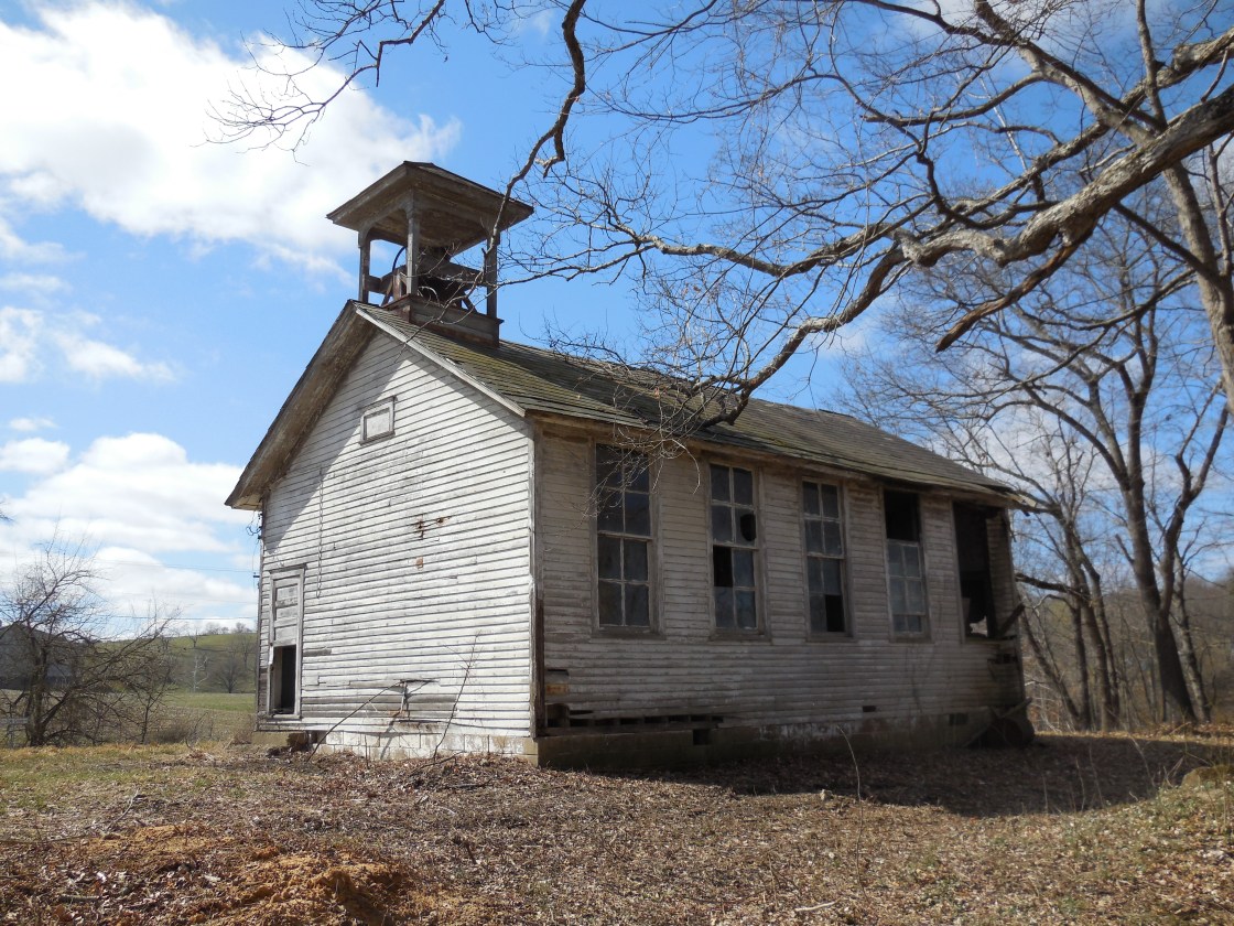
Description: There isn’t much info available online concerning the town. However, it’s a very interesting place to visit despite not knowing much about the location. Oak Grove Methodist Church was also used as the Racine Grange Hall (No. 2606). The earliest known burial in the cemetery is Rhoda (Gillett) Reynolds (1810 – 1837). She married Henry Reynolds (1808 – 1872) and moved to Ohio with him from Sullivan County, New York. The one-room schoolhouse is certainly of a dying breed. There aren’t many left in the state of its nature. The bell is amazingly still intact, which is very uncommon these days. They were usually scrapped or repurposed. The school was likely built prior to the Ohio School Act of 1853 which mandated that there be one in every 4 square miles. After the act passed, brick one-room schoolhouses were built 2 miles apart, so kids wouldn’t have to walk more than a mile to get to one.
Olive Centre – Olive Township
Post Office: 1855 – 1865
Location: unknown
Description: Origen Packard (1811 – 1985) moved to Ohio from Grafton County, New Hampshire and was the postmaster. He met and married Achsah (Cowdery) Packard (1807 – 1894) in Meigs County and had a few children. Origen and Achsah were buried with relatives in Reedsville Cemetery on the east side of SR 124 (Ohio River Scenic Byway) on the south side of Reedsville.
Rockville
Location: unknown
Description: It was on the Toledo & Ohio Central Railroad west of Middleport and was listed on the Ohio map in the 1901 George Cram atlas.
Stedmansville (Stedmans Mills) – Orange Township
Post Office: 1815 – 1823
Location: unknown
Description: Levi Stedman (1771 – 1823) from Orange County, Vermont and Dorothy (Cowdery) Stedman (d. 1827) had a few children and built a water-powered log grist mill on the Middle Fork of Shade River in 1808. The mill stones were acquired from Revolutionary War veteran Truman Hecox (1765 – 1837) from Hartford County, Connecticut and Sarah (Hasford) Hecox (1766 – 1838) from Jefferson County, New York. It was later updated to a wood frame structure. Samuel Grant Sr. purchased the mill in 1820 and rebuilt it with improved machinery. Levi Stedman was buried with relatives in Chester Cemetery on Pomeroy Pike in Chester Township. Dorothy was also likely buried there in a currently lost gravesite. Truman and Sarah Hecox were laid to rest with relatives in Mound Cemetery on the west side of Summer Rd (Co Hwy 36) in Chester Township.
Sterling (Sterling Bottom) – Lebanon Township
Post Office: 1844 – 1855
Location: 39.013152, -81.773064
on SR 124 (Ohio River Scenic Byway) at the 4-way intersection of Stiversville – Bald Knob Rd and McDade Rd along the Ohio River
Remnants: Browning (Portland) Cemetery on Browning Cemetery Rd south of the GPS coordinates
Description: Sterling was platted in 1824 by the Glasgow Ohio Company and its settlers from Scotland purchased land the land. Johnson Jenkins White (1818 – 1901) was the postmaster. He was buried with relatives in Hill (Middleport Hill) Cemetery on Cemetery Rd in Middleport. Some other residents were buried in Browning (Portland) Cemetery.
Stony Point – Chester Township
Location: 39.083583, -81.883425
on Reibel Rd (Township Hwy 113) between Oak Hill Rd and Racine – Bashan Rd along Shade River
Remnants: old houses and farm buildings in the area
Description: The town was along Reibel Rd point itself is south of the GPS coordinates on the other side of Shade River.
White Rock – Sutton Township
Location: 39.015278, -81.987655
on SR 124 (Ohio River Scenic Byway) between Minersville Rd and Monkey Isle along the Ohio River
Remnants: none known
Description: The town was named after the abundance of salt in the area. In the later 1800s the area was home to the Sutton Salt Works, a bromine factory, and a few coal industry operations.
Zeal – Columbia Township
Post Office: 1892 – 1904
Location: 39.196462, -82.295983
on Rutherford Rd between SR 32 and Harkins Rd along Raccoon Creek
Remnants: old houses in the area
Description: This small postal town was founded by its postmaster, Jasper Rutherford (1860 – 1926) and Hulda (Hunter) Rutherford (1863 – 1910). Jasper remarried after Hulda passed away. They were buried with relatives in Temple Cemetery at the intersection of SR 143 and Lemaster Rd north of the eastern end of Rutherford Rd on the other side of SR 32.
Burlingham, OH (Bungtown) – (mid-1800s – present farming and pork packing town with little to no growth)
Classification: small town
Location: Bedford Township, Meigs County – On Old SR 33 at the intersection of Burlingham Rd
We don’t have much to go by concerning the history of the town, but it does have an interesting story. In the late 1800s, the women of Burlingham were tired of their men spending too much time at the saloon. As the story goes, they proceeded to remove the corks (or bungs) from all of whiskey barrels and set the leaking alcohol on fire which resulted in saloon burning down. The Bungtown Salsa Co. 5 miles to the north in Shade, currently produces Bungtown Fatali Saloon Burner hot sauce, commemorating the event. Burlingham had a post office from 1828 – 1904. The cemetery is across from the church on Burlingham Rd.

