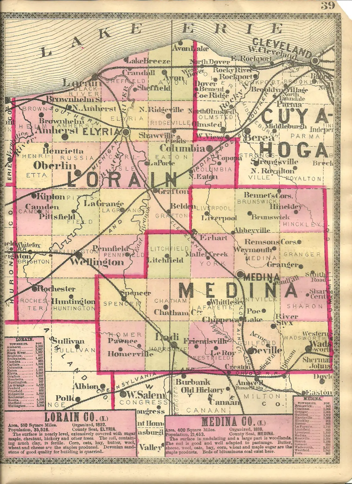
Bagdad – Medina Township
Location: 41.170907, -81.829033
on Fenn Rd at the intersection of Huffman Rd
Remnants: Medina Center (Badgad) Cemetery on the north side of Fenn Rd between Huffman Rd and Weymouth Rd
Description: Bagdad was settled in the late 1810s and had hopes of contending for the county seat in the future, but it never grew much. The town had a saw mill, grist mill, general store, and a church. Bagdad faded away into oblivion in the mid to late 1800s.
Chamberlain – Montville and Lafayette Township
Location: 41.129221, -81.878470
on US 42 (Lafayette Rd) at the railroad crossing between Ryan Rd and Oak St
Remnants: none known
Description: It was on the Cleveland, Lorain, & Wheeling Railroad and was founded by a branch of the Chamberlain family in the county.
Crow’s Corner (Crow Corner) (Crow Town) – Litchfield Township
Location: 41.186807, -82.053314
on Crow Rd at the intersection of Yost Rd along Crow Creek
Remnants: Crow Corner (Crow Road) Cemetery on the south side of Crow Rd between Yost Rd and Vermont St, old houses and farm buildings in the area
Description: John Crow (1790 – 1864) and Nancy (Wheeler) Crow (1794 – 1873) from Hampden County, Massachusetts arrived in the township along with several other families in 1832. The cemetery was established on their 165-acre farm in the southwest lot of the intersection. A school was in the northwest lot of the intersection on land donated by Solomon Halladay (1800 – 1878) from Massachusetts and Dotia (Chamberlain) Halladay (1819 – 1900) from Otsego County, New York. The school’s first cartographic appearance was in the 1874 county atlas. The Crow’s and Halladay’s residences are intact and presently occupied, along with some other old houses from the town’s existence. It was never platted and there wasn’t any major businesses. Most of the residents were farmers. A group of local investors known as the Litchfield Oil Company attempted to strike oil at Crow’s Town in 1876 but didn’t have any luck on that. Everyone mentioned in this listing was buried with relatives and other early pioneers in the cemetery.
East Montville – Montville Township
Location: unknown
Description: none found
Fishermans Corners – Hinckley Township
Location: unknown
Description: none found
Geisingers Corners – Chatham Township
Location: 41.074777, -82.024590
on Avon Lake Rd at the intersection of Shaw Rd along East Fork Black River
Remnants: none known
Description: The proprietors were John Geisinger (1827 – 1911) and Mary (Myers) Geisinger (1825 – 1907) who moved to Ohio from Pennsylvania and had a large family. John was a carpenter and employed a few workers in local construction. The town had a school and a grist mill. John and Mary were buried with relatives in Blake Cemetery on Guilford Rd in Guilford Township.
Goodmans Corners
Location: unknown
Description: none found
Hales Corners – York Township
Location: 41.142291, -81.923649
on Branch Rd at the intersection of Columbia Rd
Remnants: Branch Cemetery on private property on the south side of Branch Rd east of Columbia Rd
Description: It was founded by Samuel Hale (1812 – 1877) and Nancy (Cranmer) Hale (1817 – 1868). They moved to Ohio from New York in 1847, purchased 300 acres, and had a few children. Samuel was a farmer and brick maker but was very anti-Mason. The Hales assisted runaway slaves on the Underground Railroad who were headed to Canada and donated money for a Methodist church at York Center. Samuel and Nancy were buried with relatives in Branch Cemetery.
Lake Junction
Location: unknown, was between Chippewa Lake and Lester along the Medina Subdivision of the B&O Railroad
Description: none found
Newtons – Homer Township
Location: 41.027450, -82.149914
on US 224 (Greenwich Rd) between Firestone Rd and Camp Rd
Remnants: none known
Description: The town was founded by a branch of the Newton family in the county. It was along the B&O Railroad and had a school.
Pekin – Hinckley Township
Location: unknown
Description: none found
Pierces Corners – Granger Township
Location: 41.155635, -81.756071
on Granger Rd at the intersection of Beach Rd
Renmants: Ganyard Cemetery on the west side of SR 94 (Ridge Rd) between Granger Rd and Wilbur Rd, old houses and farm buildings in the area
Description: Pierces Corners could have just as aptly been named Spencers Corners. Nathaniel Pierce (1813 – 1888) was a bee raiser, sheep trader, and wool dealer and moved to Ohio from New York. He met Harriet (Spencer) Pierce (1821 – 1910) in Granger Township and married her in 1841. Harriet was the only child of Thomas and Hannah (Phelps) Spencer. They were from Connecticut and became pioneers in Medina County upon their arrival in 1818. Harriet inherited the family land and had 2 children with Nathaniel. The town had a school and many fine farms. Nathaniel and Harriet were buried with relatives, including Harriet’s parents, in Ganyard Cemetery.
Pliny – Liverpool Township
Post Office: 1901 – 1904
Location: 41.215331, -81.903470
on Abbyville Rd at the railroad crossing between Muntz Rd and E Law Rd
Remnants: Zion Evangelical Lutheran Church and Cemetery on the south side of the GPS coordinates
Description: It was on the Cleveland, Lorain, & Wheeling Railroad and had the church and a school. The church congregation was formed by German immigrants in the 1830s. Its current structure was completed in 1896 and replaced the old frame building that was nearly 60 years old.
Risley – Litchfield and Chatham Township
Post Office: 1892 – 1905
Location: 41.136242, -82.044232
on W Smith Rd at the intersection of Bryenton Rd
Remnants: none known
Description: Risley had a school, general store, and a train station on the Northern Ohio Railway.
Sheldons Corners – Granger Township
Location: 41.188464, -81.710106
on Remsen Rd at the intersection of State Rd
Remnants: none known
Description: The town was founded by David Sheldon (1794 – 1873) and Anna (Searles) Sheldon (1800 – 1855). It had a school and a shoe shop. A tragic death occurred on the Sheldon’s property when Lyman Isbell (1764 – 1820) was struck by a 40 foot rafter log as it rolled off a barn that local residents were helping build for David. Lyman was buried in Coddingville Cemetery on the east side of Dunsha Rd and his family later moved out of the state. David married Rebecca (Green) Sheldon (1808 – 1885) after Anna passed away. They were buried with relatives in Reid Hill Cemetery at the intersection of State Rd and Reid Hill Rd south of town.
Silver Creek – Wadsworth Township
Location: 41.011912, -81.711701
on Silvercrest Rd between Durling Dr and Silvercreek Rd
Remnants: old houses and buildings in the area
Description: Silver Creek was a coal mining town and had a train station on the New York, Pennsylvania, & Ohio Railroad with a branch running to the mines. It’s large residential section has a plat map in the 1897 Medina County Atlas. The mines and railroad branch stretched southeast along Silver Creek and employed much of the local population.
Steam Town (Steamtown) – Guilford Township
Location: 41.047034, -81.814598
on Tower Rd at the intersection of Blake Rd
Remnants: Blake Cemetery on the west side of Guilford Rd between Blake Rd and Good Rd, old houses and farm buildings in the area
Description: It was named after a steam-powered saw mill that was built there in the mid-1800s. The original one was destroyed by fire in 1867 and a second was constructed to serve the area through the late 1800s. The town also had 2 schools, a Mennonite church, blacksmith shop, and a wagon shop. Many residents were buried in Blake Cemetery.
Thompsons (Thompson’s Crossing) – York Township
Location: 41.142319, -81.967604
on Branch Rd at the railroad crossing between Erhart Rd and Bachtell Rd
Remnants: none known
Description: The town was on the Northern Ohio Railroad and its proprietor was P. M. Thompson.
Weaverville – Wadsworth Township
Location: 40.994821, -81.692596
on Weaverville Rd west off of Medina Line Rd between Eastern Rd and Silver Fox Dr
Remnants: old houses and farm buildings in the area
Description: It had a mine owned by the Wadsworth Coal Mine Company and a school.