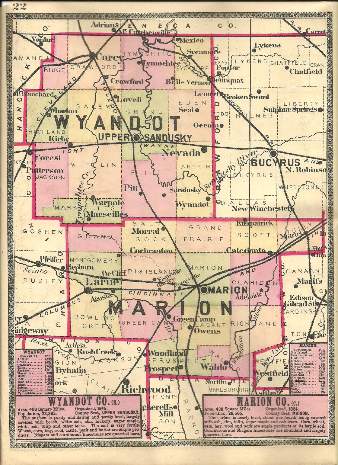
Beech – Claridon and Richland Township
Location: 40.557837, -82.976851
on Marion – Edison Rd at the intersection of Salem Rd
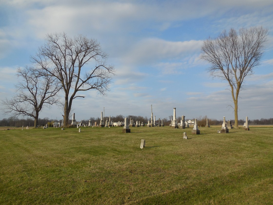
Remnants: Salem Evangelical Church and Salem Cemetery on Salem Rd north of the intersection, Lutheran Cemetery on SR 746 (S Caledonia – Ashley Rd) north of Marion – Edison Rd, old houses and farm buildings in the area
Description: It was a crossroads town named after the abundance of beech trees in the area and had a steam-powered saw mill, school, blacksmith shop, and 2 churches in the mid 1800s to early 1900s.
Belvuron – Claridon Township
Location: 40.582088, -83.040201
on SR 98 (Columbus – Sandusky Rd S) at the intersection of SR 95 (Marion – Mt. Gilead Rd)
Remnants: none known
Description: The town was platted in 1829 by War of 1812 veteran Colonel James Kilbourne (1770 – 1850) from Connecticut. He was a minister, surveyor, and served in the U.S. Congress and state legislature. James also founded a few other towns in Ohio and was buried with relatives in St. Johns Episcopal Church Cemetery in Worthington, Franklin County.
Bethlehem – Waldo and Pleasant Township
Location: 40.483731, -83.131743
on Bethlehem Rd W at the intersection of Smeltzer Rd
Remnants: Trinity Evangelical Lutheran (Bethlehem) Church 1 mile north at the intersection of Smeltzer Rd and Newmans – Cardington Rd W, old houses and farm buildings in the area
Description: The original group of settlers arrived in 1832. It had 2 churches, a blacksmith shop, and a school in the late 1800s.
Clyde Settlement – Tully Township
Location: 40.689658 -82.938946
on Morral – Kirkpatrick Rd E at the intersection of Timpson Rd
Remnants: none known
Description: This first settlement in the township was named by Alanson Packard after the song “Banks Of The Clyde”, referring to a river in Scotland, which was routinely sung by Samuel Hazlet.
Gurley (Gurleys Station) – Big Island Township
Post Office: 1879 – 1901
Location: 40.586169, -83.255751
on Espyville Rd N at the intersection of SR 95 (Marion – Agosta Rd)
Remnants: none known
Description: It was founded by John Gurley (1813 – 1892) and Hannah (Monnett) Gurley (1817 – 1880) who were prominent citizens in the township, had a 160-acre farm, and one son. The town had a train station on the Bee Line of the Cleveland, Columbus, Cincinnati, & Indianapolis Railroad. There was also a school on the north side of SR 95. John and Hannah were buried with relatives in Marion Cemetery on Delaware Ave in Marion.
Harvey – Grand Prairie Township
Location: 40.652015, -83.119040
on SR 4 (Marion – Bucyrus Rd) at the intersection of Linn – Hipsher Rd
Remnants: none known
Description: The proprietor David Harvey (1821 – 1902) from Pennsylvania accumulated about 1,200 acres in Grand Prairie Township, Marion Township, and Crawford County. He farmed grains, wool, and dealt livestock. David had 7 children with his first wife Calista (Everett) Harvey (1829 – 1861) and helped raise his second wife’s children, Lucinda (Morris) Bell Harvey (1830 – 1887), who was also widowed. On top of that, his brother William Harvey (1819 – 1861) passed away of typhoid less than a month after being elected Marion County Sheriff and David looked after his widow and their younger children. He was buried with relatives in Marion Cemetery on Delaware Ave in Marion.
Holmesville (Parrtown) – Bowling Green Township
Post Office: dates not listed
Location: 40.542834, -83.359643
on SR 37 (Richwood – Larue Rd) at the intersection of Guthery Rd
Remnants: none known
Description: The town was founded by Thomas Parr (1814 – 1898) and Sarah Ann (Pitzer) Parr (1817 – 1899) who moved to Bowling Green Township from Licking County and had a few children. Holmesville had a tavern, wagon shop, blacksmith shop, a few stores, and a horse-powered grist mill built by Thomas. It was abandoned as it couldn’t compete with La Rue, which drew away businesses and grew quicker. Thomas and Sarah moved to Illinois and were buried with relatives in West Serena Cemetery in Serena.
Hoover – Scott Township
Post Office: 1892 – 1898
Location: unknown
Description: It had a freight station on the Columbus, Sandusky, & Hocking Railroad.
Hords – Big Island Township
Location: 40.592558, -83.192971
along the Marion Tallgrass Trail between Herr Rd and Marion – Williamsport Rd W
Remnants: none known
Description: This small farming town was founded by a branch of the Hord family in the county and was on the Chicago & Atlantic Railroad.
Kirbys – Grand Prairie Township
Location: unknown
Description: none found
Little Scioto
Post Office: 1842 – 1852
Location: unknown, was along the Little Scioto River
Description: none found
Logan – Marion and Claridon Township
Location: 40.605059, -83.073522
on Pole Lane Rd at the railroad crossing and intersection of E Fairgrounds Rd
Remnants: none known
Description: Logan was on the Bee Line of the Cleveland, Columbus, Cincinnati, & Indianapolis Railroad.
Longville (Bryan Station) – Big Island Township
Post Office: 1873 – 1894
Location: 40.585613, -83.217416
on SR 203 (Prospect – Upper Sandusky Rd S) at the railroad crossing and intersection of SR 95 (Marion – Agosta Rd)
Remnants: none known
Description: The town was named after Peter Long, had a school, and was on the Bee Line of the Cleveland, Columbus, Cincinnati, & Indianapolis Railroad.
Middle Spring – Salt Rock Township
Post Office: 1837 – 1838
Location: unknown
Description: It was listed in The Ohio Gazetteer and Traveler’s Guide from 1837 – 1841.
Salem – Big Island Township
Location: 40.607753, -83.279143
on Decliff – Big Island Rd at the intersection of Schmidt Rd
Remnants: Salem Cemetery at the intersection
Description: This small farming town had a church and a school.
Slab Camp – Pleasant Township
Location: 40.483828, -83.102200
on Bethlehem Rd W at the railroad crossing between Benzler Rd and SR 423 (Marion – Waldo Rd)
Remnants: Drake Cemetery on the east side of SR 423 next to Qu Qua Creek
Description: Newly arriving settlers built temporary tents and cabins to reside in before purchasing lots in the area on the eastern edge of what would later be the town of Bethlehem. The land was owned by War of 1812 veteran William Drake (1769 – 1850) and Rebecca Drake (1768 – 1855). They moved to Ohio from New York in 1808 and had 7 children. Their son Daniel Drake (1805 – 1881) inherited the property and kept the camp going. William and Rebecca were buried with relatives and other early pioneers in Drake Cemetery.
Slicks (Slicks Station) – Marion Township
Location: unknown, was northwest of Logan
Description: The town was on the Erie Railroad and was founded by Philip Slick who operated a tavern and inn for travelers.
Smiths Mills – Richland Township
Location: 40.512865, -83.031435
on Cardington Rd along the Olentangy River between Whetstone River Rd S and East River Rd
Remnants: Smith Cemetery on the north side of Whestone River Rd S between Mautz – Yeager Rd and Cardington Rd
Description: The patriarch and matriarch of the family were blacksmith William Smith (1792 – 1835) and Elizabeth Smith (1792 – 1862) from Maryland who had a nice farm and a few children. Their son William Washington Smith (1821 – 1912) was the proprietor of the Smith & Co. mills. Titus King (1793 – 1868) and Margaret (Storm) King (1808 – 1861) from Vermont also owned a saw mill in town and were the namesake of the present day Kings Mills Golf Club. Their son George King (1832 – 1883) expanded the saw mill with a grist mill. Some of the town’s residents were buried in Smith Cemetery.
Stringtown – Tully Township
Location: 40.674503, -82.948518
on Marseilles – Galion Rd E at the intersection of Lyons Rd
Remnants: old houses and farm buildings in the area, Bruchlacher (Brooklocker) Cemetery north of the GPS coordinates at the intersection of Morral – Kirkpatrick Rd E and Lyons Rd
Description: It had a school and a church on Morral – Kirkpatrick Rd E east of the cemetery.
Stumptown
Location: unknown
Description: There are a couple references to it in the 1883 The History of Marion County, Ohio with no location or town info.
Wilson
Post Office: 1848 – 1856
Location: unknown
Description: none found
Winnemac – Bowling Green Township
Location: 40.572366, -83.394164
on Winnemac Pike at the intersection of Larue – Mt Victory Rd
Remnants: Bonner Cemetery north of the intersection and railroad tracks on the west side of Winnemac Pike, former one-room schoolhouse about 1/2 of a mile west of the GPS coordinates at the intersection of Larue – Mt Victory Rd and Clark Rd S, old houses in the area
Description: Winnemac was platted in the mid-1800s with a small residential section on the south side of Larue – Mt Victory Rd just east of the GPS coordinates. The town was along the Bellefontaine and Indiana Railroad (later the Cleveland, Columbus, Cincinnati, & Indianapolis Railroad). A nice wood frame church that could seat 200 parishioners was built in 1853 at a cost of $500. It was physically moved to the nearby and much faster growing town of La Rue in 1862. Winnemac’s first school was in the northeast corner of the intersection of Larue – Mt Victory Rd and Clark Rd S. It was replaced in 1887 with a new school across the road (Bowling Green Township No. 3) which remains in decent preserved condition. The building was also referred to as the Lenox School, named after the family who owned the land. A small brickyard on the east side of Winnemac Pike across from the cemetery was owned by Marsh & La Rue and was pinpointed in the 1878 county atlas. Land for the cemetery was purchased from the 200-acre farm of John Bonner (1811 – 1894) and Elizabeth (Young) Bonner (1801 – 1883) who were buried there with relatives and other early residents of the area. It was laid out into lots in 1857. Some of the interments are a bit older than that.