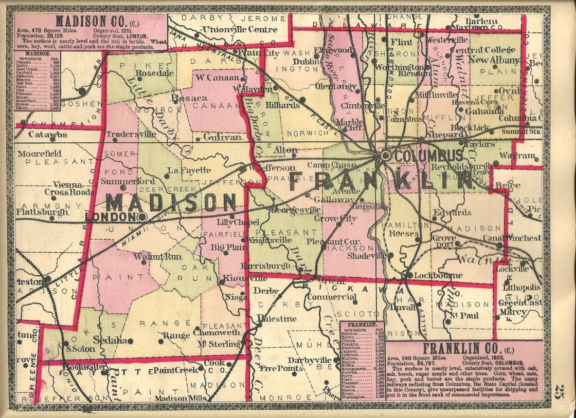
Carters – Deer Creek and Jefferson Township
Location: 39.939713, -83.362897
on US 40 (National Pike) at the intersection of Glade Run Rd along Glade Run
Remnants: Wright Cemetery on the east side of Glade Run Rd about 1/2 of a mile south of the GPS coordinates
Description: The town was named after the Carter family in the area, dating back to George W. Carter (born c. 1804) from Pennsylvania and Matilda (Brown) Carter (born c. 1810) from Virginia. They had at least 8 children and owned a 443-acre farm on the south side of US 40 east of the intersection, including the land where National Road Golf Course is presently located. A school was on the north side of US 40 just west of the GPS coordinates. The burial location of George and Matilda is unknown. George was last listed as widowed in the 1880 census. Wright Cemetery was established on land originally owned by James A. Wright (1762 – 1824) and Elizabeth (Reagan) Wright (1763 – 1824) from North Carolina.
Darby Crest – Jefferson Township
Location: 39.947157, -83.236226
on Riverside Dr and Darby Dr along Big Darby Creek south of US 40
Remnants: none known
Description: The old town is long gone, but the current residential neighborhood of Darby Crest Estates hangs onto the name.
Deer Creek Village – Somerford Township
Location: 39.968401, -83.474919
on Arbuckle Rd (Co Hwy 110) near Deer Creek between SR 187 and Gwynne Rd (Township Hwy 111)
Remnants: none known
Description: Deer Creek Village was a Native American town founded in 1794 by Tecumseh (1768 – 1813) before he became chief of the Shawnees. It was mostly used for riding out winters and usually offered a decent supply of deer even during the cold months. The Shawnees were displaced at the time, having been driven out of their former villages during the Northwest Indian War of 1785 – 1795. Tecumseh married Mohnetohse (1770 – 1798) from Arkansas in Deer Creek Village and waited for the results of the Treaty of Greenville there. After the treaty was signed in 1795, Native Americans had the option of returning to their previous villages as long as they agreed to remain peaceful. The tentative peace lasted for about 15 years until the events leading up to the War of 1812, which were mostly instigated by the British government.
Deersville – Stokes Township
Location: unknown
Description: It was listed in The Ohio Gazetteer, Or, Topographical Dictionary and The Ohio Gazetteer and Traveler’s Guide from 1833 – 1841.
Johnstons – Range, Oak Run, Paint, and Union Township
Post Office: 1828 – 1844
Location: 39.789583, -83.415325
on Yankeetown – Chenoweth Rd (Co Hwy 9) at the intersection of Johnston Rd
Remnants: Old Johnston Cemetery on the east side of Johnston Rd next to Bradford Branch about 1/4 of a mile northeast of the intersection, Johnston – McClimans Cemetery on the west side of Yankeetown – Chenoweth Rd next to Dunkin Ditch 2 1/3 miles southeast of the intersection
Description: The proprietors were county pioneers William Johnston (1781 – 1866) and Margaret (McClimans) Johnston (1784 – 1862). They moved to Ohio from Pennsylvania around 1805, resided in Ross County for a while, and settled in Madison County in 1813. William was the town’s postmaster and served as justice of the peace. A school was on the east side of Yankeetown – Chenoweth Rd 1 1/2 mile southeast of the GPS coordinates on a farm owned by the McClimans family. William and Margaret had 8 children, owned a large farm, and were buried with relatives in Johnston – McClimans Cemetery. Some of the other family members were laid to rest in Old Johnston Cemetery.
Markley – Somerford Township
Location: 39.932526, -83.515190
on US 40 (National Rd) at the intersection of Markley Rd along Deer Creek
Remnants: Diamond Rock Stock Farm barn on the west side of Markley Rd 1 1/4 miles southwest of the GPS coordinates
Description: Jonathan Markley (1780 – 1849) and Rachel (Schriner) Markley (1794 – 1820) moved to Ohio from Maryland and had 3 children. Jonathan married Mary Jane (Cryder) Markley (1800 – 1849) after Rachel passed away and had 8 more children. They Markleys accumulated 413 acres of farmland and were laid to rest in Somerford (Somerford Township) Cemetery 2 1/3 miles northeast of the GPS coordinates on SR 56 (W Urbana – Loudon Rd). Some of their children and grandchildren continued with farming on the old homestead. The town had a school on the north side of Markley Rd just southeast of the GPS coordinates in the late 1800s. Daniel Lucy (1864 – 1923) was the proprietor of the 107-acre Diamond Rock Stock Farm. He raised hogs for market and built the German-style bank barn in 1904 which still stands today. Daniel was buried 5 1/3 miles east of the GPS coordinates in Upper Gwynne Farm (Deer Creek Township) Cemetery on the south side US 40 in Lafayette.
Myers – Union Township
Location: 39.890221, -83.529241
on Davis Rd at the railroad crossing between Old Springfield Rd and US 42
Remnants: old houses and farm buildings in the area
Description: Myers was on the Cleveland, Cincinnati, Chicago, & St. Louis Railroad (Big Four Railroad) in the late 1800s to early 1900s. It had a school about 1 1/2 miles northeast of the GPS coordinates on the south side of Old Springfield Rd. Mail went through an express office with no physical building or appointed postmaster.
Nioga – Pleasant Township
Post Office: 1887 – 1900
Location: 39.782805, -83.318738
on SR 56 (London – Circleville Rd) at the intersection of Robinson Rd
Remnants: none known
Description: John W. Timmons (1831 – 1907) was the town’s postmaster. He married Edytha (Oglesbee) Timmons (1830 – 1917) and had a few children. John and Edytha were buried with many relatives and other residents of Nioga in Pleasant (Alkire) Cemetery 6 miles southeast of the GPS coordinates on Era Rd. A school (Pleasant Township No. 5) was in the southeast corner of the intersection on an 87-acre farm owned by the Neff family. There was also a fish stock farm with weight scales and a small deer park on a 508-acre farm owned by the Gwynn family on the west side of SR 56 across from Robinson Rd.
Roberts – Jefferson Township
Location: 39.942738, -83.306517
on US 40 (National Rd) at the intersection of SR 29 (Urbana – West Jefferson Rd)
Remnants: Pleasant Hill Cemetery 1 1/4 east of the GPS coordinates on the north side of US 40
Description: The town was founded by Thomas Roberts (1775 – 1864) and Susan (Boisel) Roberts (1779 – 1864) who moved to Ohio from Virginia in the early 1800s, had several children, and accumulated much of the land on the west side of West Jefferson. A long stretch of the homestead was donated for track bed of the Columbus & Xenia Railroad. The land was split up between the Roberts children and they continued the family’s success in the area. Sebastian Roberts (1814 – 1869) platted Pleasant Hill Cemetery in 1864. Thomas was its first interment.
Wahoo – Deer Creek Township
Post Office: 1852 – 1867
Location: 40.001451, -83.435227
on SR 29 (Urbana – West Jefferson Rd) between SR 38 (Marysville – London Rd) and the northwestern township border
Remnants: none known
Description: Wahoo was a small farming town and postal town with a church and school. Mary A. (Dun) Thurman (1812 – 1891) donated land for the church in 1858. She was buried with relatives in Green Lawn Cemetery on Greenlawn Ave in Columbus. The Duns were the biggest family in the area and did most of the church construction. The post office and church were on the north side of SR 29 near the GPS coordinates and the school was a mile southeast of the GPS coordinates in the southwest corner of the intersection of SR 29 and SR 38 (London – Marysville Rd). They were all pinpointed on the 1862 county map. DeWitt C. Sawyier (1825 – 1899) was the first postmaster. He moved to California and was buried with relatives in Live Oak Memorial Park on at the intersection of E Duarte Rd and S California Ave in Monrovia on the northeast side of Los Angeles. Hugh Dillow (1832 – 1904) was the last known postmaster.
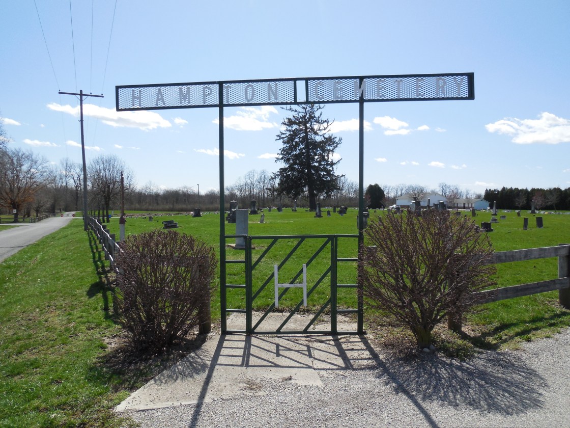
New Hampton, OH (Hamden) – (1822 – 1840 farming town abandoned when the National Road (US 40) was built)
Classification: ghost town
Location: Jefferson Township, Madison County – On Frey Ave near Hampton Cemetery
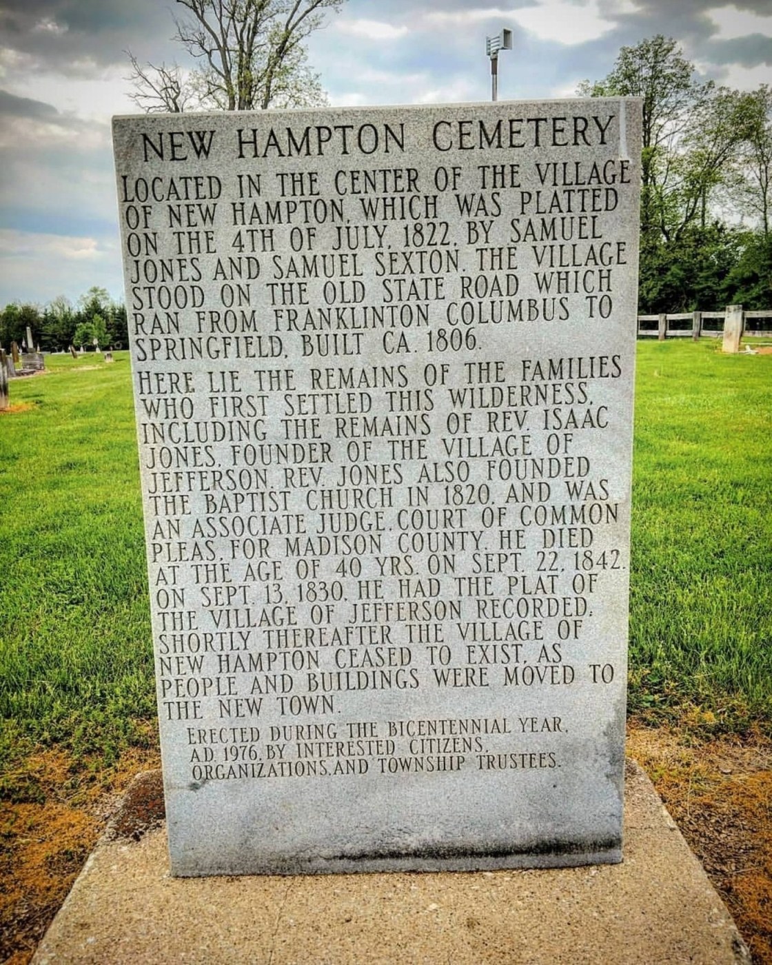
It was platted in 1822 along Ludlow’s Rd, the first state road in Ohio, by Samuel Sexton and Samuel Jones who were business men from New Jersey. Back then, Ludlow’s Rd was a vibrant trading route and a promising place to start a town. New Hampton had 2 general stores, 3 taverns, a Baptist church, and a post office from 1830 – 1833. Reverend Issac Jones (1802 – 1842) and Eliza (Mills) Jones (1804 – 1877), a son and daughter in law of Samuel Jones, platted Jefferson (now West Jefferson) in 1831 a few miles north of New Hampton in anticipation of the National Road (US 40) being built through the area.
Residents of small towns just to the north and south, all across the state, flocked to the National Road, moving their families, houses, and businesses to its promise of a better life. New Hampton was no exception to that. The cemetery and part of the Main Street of Ludlow’s Rd are the only known remnants left. Ohio Historical Marker #2 – 49 at the front of New Hampton Cemetery on Frey Ave tells the story of New Hampton and Ludlow’s Rd. Samuel Sexton and Samuel Jones moved back to New Jersey with their families when New Hampton was abandoned, unhappy that the town they founded no longer existed.
Thanks to group member Ashley Murray, manager of Around West Jefferson Ohio, for providing the listing pic!

West Jefferson, OH (Jefferson) – (1830 – present farming, mill, and railroad town that acquired most of New Hampton’s residents)
Classification: small town
Location: Jefferson Township, Madison County – on US 40 west of Columbus
West Jefferson rose out of the dust of a failed town and was once the most important business point in Madison County. Residents needed a commercial center in Jefferson Township closer to home than the 15 – 20 mile journey to Columbus, called Franklinton at the time. Samuel Jones and Samuel Sexton moved to the area from New Jersey and platted New Hampton on July 5, 1822 along Little Darby Creek and Ludlow’s Road, the first state road in Ohio.
The town was laid out with 93 lots on 8 streets on the south side of Hampton Cemetery on Frey Ave in West Jefferson. It had 2 general stores, a post office, three taverns, a hotel, and a brick Baptist church at the cemetery. The lot for the cemetery was donated by Samuel Jones in 1823. His wife Elizabeth was the first burial there later that same year. Samuel Sexton’s wife Sarah and daughter Elizabeth followed in 1827.
New Hampton unfortunately wasn’t growing fast enough in the late 1820s. New of the National Road, current day US 40, being constructed to the north spelled the end for the town. It was the first federally funded highway in the county, and when completed, connected Cumberland, Maryland to Vandalia, Illinois. Samuel Jones and Samuel Sexton moved back to New Jersey, leaving behind many departed family members and the dreams of creating a successful village. At least part of that same dream lived on through the efforts of a son and daughter-in-law of Samuel and Elizabeth Jones.
Reverend Isaac Jones (1802 – 1842) and Eliza (Mills) Jones (1804 – 1877) inherited some of Isaac’s parents land along the National Road on November 17, 1830. They founded Jefferson and platted the town in September of 1831 with 64 lots. Its post office opened in 1833 but was called West Jefferson to avoid confusion with other towns in Ohio named Jefferson. By 1834 the town already had 700 citizens. Business boomed along the National Road and in West Jefferson in the 1840s and 1850s. Lumber mills and merchant shops fueled the local economy on top of farming and livestock raising.
On the northwest side of town, War of 1812 veteran John Blair (1788 – 1870) from Virginia and Jency (Jennie Thompson) Blair settled in the township in 1843. They were married in 1814 while John was running a hat business in London, OH and had 7 children. Their oldest child, George W. Blair (1817 – 1886) married Rachel (Goodson) Blair (1820 – 1883). They had 10 children and lived on George’s parents old 300-acre farm. George and Rachel welcomed a Methodist congregation into their home for services for 9 years until donating land for a church and cemetery. Blair Chapel was constructed in 1853 with $700 in funds raised for the structure. The church has since been lost to time.
On top of owning and operating the first steam-powered thresher and reaping machine in the county, George managed construction of 3 miles of Blair Pike in 1868 – 1870. The road still bears the family name along with a branch of the Taylor family that later settled in the area. John, Jency, George and Rachel were buried with relatives in Blair Cemetery on Taylor Blair Rd. The road also had 2 steam-powered saw mills and a water-powered saw mill on Little Darby Creek in the mid to late 1800s.
Back in town, West Jefferson was flourishing with a grist mill and pork packing industry. It had 5 hotels at its peak with passenger and goods stagecoaches lining the streets. Sebastian Roberts (1814 – 1869) and Tacy (Holt) Roberts (1821 – 1889) donated land for Pleasant Hill Cemetery on US 40 in 1864. Sebastian’s parents, Thomas and Susan, formerly owned most of the land on the west side of town and were the first burial there in 1864. A two-story high school was built in 1868 at a cost of $17,000 including the grounds and furniture. Everything was going great until the Little Miami River arrived in town.
Railroads were usually a blessing for town in the mid to late 1800s, but it initially hurt businesses on the National Road and in West Jefferson. Goods shipped in on trains were cheaper than those made locally, but a wool mill and carriage factory kept the town going. In 1883 the town population was around 800 and there was only one hotel remaining. Residents adapted to the changing times though and business picked up again with the addition of the Murray Lumber Company in 1890.
A town hall and an opera house that could entertain 600 residents were constructed in 1898 and a new high school was built in 1911 at the intersection of Frey Ave and Fellows Ave. The Pennsylvania Railroad bought out the Little Miami and raised the tracks through town in 1913 – 1914 to prevent traffic accidents. Its last passenger station is on N Walnut St south of the railroad underpass. The town population was 1,070 in 1915 with street lights and businesses illuminated by natural gas piped in from Columbus. A junior high school was later attached to the high school and both were demolished in 2007. Isaac and Eliza Jones were buried in Hampton Cemetery.
West Jefferson’s current population is around 4,300. Since 1951, the town conducts an annual West Jefferson Ox Roast during Labor Day Weekend. 5,000 pounds of meat are lovingly prepared by volunteers and cooked in a 140 foot long, 4 feet wide by 4 feet deep pit. Streets are closed for a parade and they also run talent contests and other events. A market place is set up for craft and commercial vendors, and more food stands.
Ox Roast Info – http://www.westjeffoxroast.org/index.html
Thanks to group member Ashley Murray, manager of Around West Jefferson Ohio, for providing the listing lead, pic, and some of the info on West Jefferson!