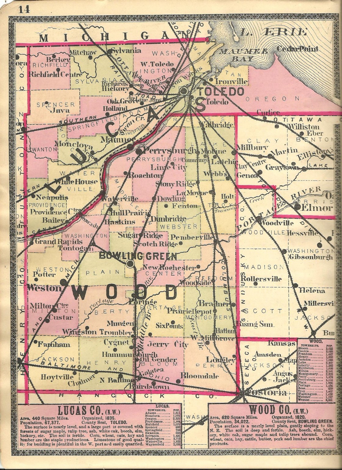
Austerlitz
Location: unknown
Description: During construction of the Miami & Erie Canal, 15 towns were platted on a 15 mile stretch of the Maumee River. They were all hoping to eventually become the head outlet of the canal and basically strike it rich with that honor. Only a few of those 15 towns survived. Austerlitz wasn’t one of them. It was approximately 6 miles above the mouth of the Maumee River and a mile above Oregon.
Bowen – Richfield Township
Location: 41.715964, -83.797023
on Sylvania – Metamora Rd at the intersection of Richfield Center Rd along Tenmile Creek
Remnants: none known
Description: It was founded George L. Bowen (1823 – 1868) born in Ohio and Esther Bowen (1823 – 1892) from New York. They owned an 80-acre farm in the southwest lot of the intersection, had a few children, and donated land for a school on their farm. The small farming town didn’t have a village and fell into obscurity in the late 1800s. George and Esther were buried with relatives 4 miles southeast of the GPS coordinates in Wolfinger Cemetery on Woflinger.
East Marengo (Central Grove) – City of Toledo (formerly in Adams Township)
Location: 41.606484, -83.592378
on River Rd at the intersection of Marengo St along the Maumee River
Remnants: none known
Description: East Marengo and its predecessor Marengo, just to the west, also had hopes of becoming the head outlet of the Miami & Erie Canal. Marengo was platted in 1836 with hefty expectations of quickly selling 300 – 500 lots. However, the lots weren’t nearly as immediately desirable as expected. The town was abandoned by order of court in 1838, which usually indicates that the proprietors failed to make sufficient payments on land debt. East Marengo was subsequently projected, but never fully evolved into what the founders had intended and was last spotted on the Adams Township map in the 1900 county atlas. By that time, the name East Marengo seems to mostly have been nostalgically used. The area was previously listed as Central Grove in the 1875 county atlas and still goes by that name today as a neighborhood of Toledo.
Everett (Everett Station) – City of Toledo (formerly in Adams and Waynesfield Township)
Location: 41.596663, -83.621048
on S Byrne Rd at the railroad crossing between Glanzman Rd and Copeland Blvd
Remnants: none known
Description: The town was platted in 1876 by Civil War veteran Brayton O. Everett (1843 – 1915) and had a train station on the Wabash Railroad in the southwest lot of the GPS coordinates.
Homestead – City of Oregon (formerly in Oregon Township)
Location: 41.651305, -83.482282
on Seaman Rd at the intersection of Berlin Ave along Otter Creek
Remnants: none known
Description: Homestead was basically platted as an early suburb and had a train station called Oregon on the Wheeling & Lake Erie Railroad. John C. Klotz (1820 – 1899) from Virginia was a successful cigar manufacturer. Along with a few other proprietors, John wanted to build an addition for the average working person to be able to afford a house and a small chunk of land. The plat was on the north side of the GPS coordinates and was eventually annexed into the City of Oregon. John was buried with relatives in Woodlawn Cemetery on SR 120 (Central Ave) in Toledo.
Lucas City – City of Toledo (formerly in Oregon Township)
Location: 41.683953, -83.474403
on St Lawrence Dr at the intersection of John Q Carey Dr
Remnants: none known
Description: Lucas City was platted in 1836 by Willard Smith, Eli Hart, and George Humphrey. It consisted of 1,500 lots and was founded in anticipation of getting the outlet of the Miami & Erie Canal. The lots didn’t sell well, to put it mildly, and Lucas City quickly went into foreclosure never having attained an actual existence aside from on paper.
Manhattan – City of Toledo (formerly in Manhattan Township)
Location: 41.684844, -83.489101
on Summit St at the intersection of Suder Ave
Remnants: none known
Description: As it turned out, Manhattan received the distinction of getting the outlet of the Miami & Erie Canal. It was founded in 1835 and acquired several amenities such as a store, hotel, grist mill, and warehouses for unloading products from large steam-powered cargo boats crossing Lake Erie. However, most of the boats were stopping in Toledo, which had better railroad access, instead of Manhattan and the proprietors of Manhattan weren’t doing enough to persuade the boat owners to do otherwise. Of course, the warehouse owners were aware of that situation and moved their businesses to Toledo. It was a disastrous domino effect for Manhattan. The plat was vacated in 1848 by approval of an application to court from the few lot owners that were left. Toledo’s booming growth eventually annexed the Manhattan area.
Midway – Swanton Township
Location: 41.588522, -83.825421
on SR 2 (Airport Hwy) at the intersection of SR 295
Remnants: none known
Description: Midway was a farming town with a train station on the New York Central Railroad and the Indiana Electric Line. It served as a shipping point for produce grown in the area and helped keep transportation costs down for local farmers.
Miami – City of Maumee (formerly in Waynesfield Township)
Location: 41.573590, -83.627233
on River Rd at the intersection of Michigan Ave along the Maumee River
Remnants: Fort Miamis Park and state memorial on the south side of the GPS coordinates
Description: Fort Miami (Fort Miamis) was built by British troops in 1794 as a way to stall General “Mad” Anthony Wayne (1745 – 1796) from advancing on to Fort Detroit which was in possession of the British during the Northwest Indian War. Fort Miami was abandoned by the British in 1796. A community of American settlers occupied the area surrounding the fort in the early 1800s. British forces took control of the fort again during the War of 1812, battling against the American forces at Fort Meigs across the Maumee River in present-day Perrysburg in Wood County. The British abandoned Fort Miami for their last time in 1814. Yet again, American settlers rolled in and turned the site into a town. The fort structure was eventually demolished and the town of Miami was annexed into Maumee as it rapidly grew through the early 1900s. The fort location was listed on the National Register of Historic Places in 1975 and was designated as a National Historic Site in 1999. It’s currently part of the Toledo Area Metroparks system.
Neowash – Waterville Township
Post Office: 1882 – 1900
Location: 41.474056, -83.767088
on Neowash Rd at the intersection of Noward Rd
Remnants: old houses and farm buildings in the area
Description: The town was never platted but formed a village of sorts around the Toledo, St. Louis, & Western Railroad, also known as the Clover Leaf, after it was constructed through the area. As with Midway, Neowash was a trading and shipping point for local goods.
Nero – Monclova Township
Post Office: 1881 – 1888
Location: 41.542862, -83.732917
on Waterville Monclova Rd at the intersection of the Wabash Cannonball Trail (South Fork)
Remnants: a couple of old houses in the area
Description: Nero was also on the Toledo, St. Louis, & Western Railroad (Clover Leaf) and formed after it was constructed through the area. Henry L. Jones was the postmaster. The Wabash Cannonball Trail is a paved recreational path along the former railroad track bed.
New Jerusalem – Jerusalem Township (formerly in Oregon Township)
Location: 41.638678, -83.302571
on SR 2 (Jerusalem Rd) at the intersection of Lyon Rd (Co Rd 185) along Cedar Creek
Remnants: none known
Description: It first appeared on the 1888 county map and was originally called Jerusalem. Although the area was never abandoned, it lost its town status while being squeezed out of existence by nearby Yondota and Bono. New Jerusalem didn’t make it onto the Ohio map in the 1901 George Cram atlas.
Presque Isle – Waterville and Monclova Township
Post Office: 1888 – 1906
Location: 41.536702, -83.714230
on Stitt Rd at the intersection of Black Rd
Remnants: none known
Description: It was a farming and postal town along the Toledo, St. Louis, & Western Railroad (Clover Leaf). Civil War veteran Frank K. Laha (1836 – 1922) from Monroe County, Michigan was the postmaster. He was buried with relatives in Wakeman Cemetery 3 1/2 miles south of town on the south side of Farnsworth Rd in Waterville.
Richards (Ottawa Hills) – City of Toledo (formerly in Adams Township)
Post Office: 1879 – 1901
Location: 41.660883, -83.641209
on Richards Rd at the railroad crossing between Bancroft St and SR 246 (Dorr St)
Remnants: Joy (Adams Township) (Bowen) Cemetery 1 mile northwest of the GPS coordinates on the east side of Underhill Rd
Description: Back before Ottawa Hills was established, the area was called Richards and had a train station on the Lake Shore & Michigan Southern Railway. The station was on the north side of the tracks next to Richards Rd on the west side of the GPS coordinates. The proprietors were from a branch of the Richards family in the county with an E. Richards being the first postmaster. J. D. Bowen was the last postmaster.
Rockwell Junction (Rockwell) – City of Oregon (formerly in Oregon Township)
Location: 41.618535, -83.504938
on the south side of Oakdale Ave at the railroad junction west of Otter Creek
Remnants: intact train track junction
Description: The town had a train station at the junction of the Lake Shore & Michigan Southern Railway and the Hocking Valley Railway and was mentioned in volume 1 of the 1910 Memoirs Of Lucas County And The City of Toledo.
Scotts Corners – Swanton Township
Location: 41.589170, -83.863614
on Scott Rd at the intersection of Brindley Rd along Ai Creek
Remnants: Swanton Township (East Swanton) Cemetery on the east side of Scott Rd south of the GPS coordinates
Description: Scotts Corners was platted in 1836 by James Jackson and James H. Forsyth from Maumee. Its first businesses were a wagon shop owned by Chester Scott (1792 – 1868) from New York and a blacksmith shop operated by James Williams. Reuben Hastings opened the first general store and ran a hotel and tavern from 1844 – 1846. Construction of the Northern Indiana Air Line railroad was completed through the area in 1858 and later became part of the Lake Shore & Michigan Southern Railway. The town also had a saw mill on the east side of Scott Rd just north of the railroad tracks. A school was on the north side of the East Swanton Cemetery on land owned by Dr. William A. Scott (1823 – 1907) and Elanor (Johnson) Scott (1823 – 1892). They were buried in the cemetery along with several other family members including William’s paternal grandfather, Revolutionary War veteran Joel Scott (1751 – 1835) from New York. Despite its promising start, the plat’s residential lots didn’t sell or form into a village. As a result, Scotts Corners remained a rural community and eventually faded out of existence.
Searles – City of Toledo (formerly in Adams Township)
Location: 41.652817, -83.621141
on SR 246 (Dorr St) at the intersection of Searles Rd
Remnants: none known
Description: Its proprietors were the family of William Searles (1815 – 1881) and Catherine (Williams) Searles (1823 – 1886). The town had a school on the north side of SR 246 near the GPS coordinates that was listed in the 1875 county atlas. The Searles family was buried in Woodlawn Cemetery on Central Ave in Toledo.
Tondaganies Village – Waterville Township
Location: 41.466754, -83.767138
on US 24 (S River Rd) at the intersection of Noward Rd along the Maumee River
Remnants: none known
Description: This Native American town was founded by Ottawa Chief Tontogany (Tondaganie), nicknamed “The Dog”. The town of Tontogany, a few miles south across the Maumee River in wood county, was platted in 1855 and was named after him.
Treadway (Tredway) – Richfield Township, Lucas County and Amboy Township, Fulton County
Location: 41.712161, -83.880181
on Fulton – Lucas Rd at the 4-way intersection of Sylvania – Metamora Rd and Co Rd U along Tenmile Creek
Remnants: none known
Description: The town was founded by the Reuben Tredway (1803 – 1886) from Jefferson County, New York and Nancy (Smith) Tredway (1800 – 1885) from Rutland County, Vermont. The married in 1825 in New York, had 9 children, and owned a 90-acre farm in the southwest lot of the intersection. Garret Vrooman (1818 – 1899) and Salley (Tredway) Vrooman (1826 – 1897) owned a cooper shop on a 97-acre farm on the east side of the Tredway homestead. There was a school in the northwest corner of the intersection on the Fulton County side in the late 1800s and another one a mile east of the GPS coordinates in the northwest corner of the intersection of Sylvania – Metamora Rd and Lathrop Rd. Most of the Tredway family was laid to rest in Amboy Township Cemetery 3 1/2 miles southwest of the GPS coordinates at the intersection of SR 64 and County Rd S in Fulton County.
Providence, OH – (1836 – present mill and canal town mostly abandoned over time but later repopulated)
Classification: ghost town
Location: Providence Township, Lucas County and Grand Rapids Township, Wood County – On Old US 24 (Lucas County Rd 53) at the intersection of Providence – Neapolis Swanton Rd
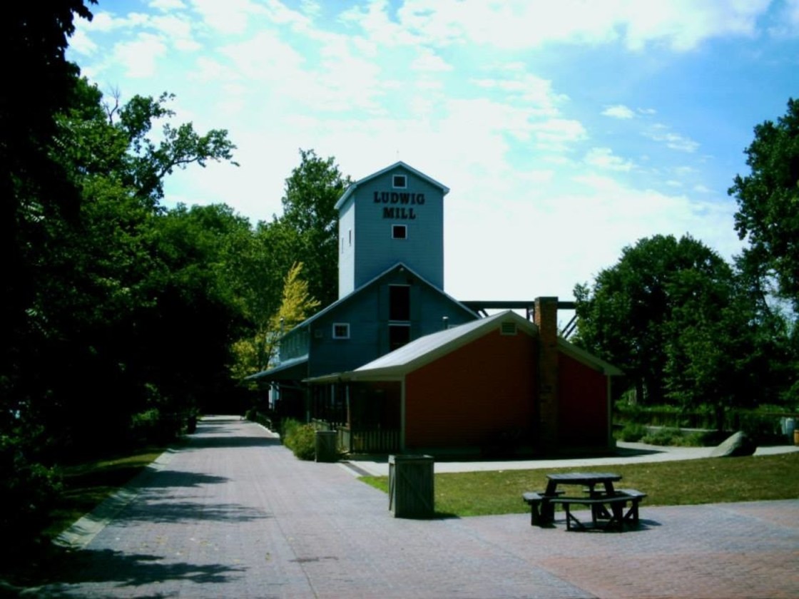
Peter Manor (1778 – 1847) settled in the area in 1816. He was a fur trader who previously operated a trading post for the Northwestern Fur Company. Peter built a saw mill in 1822 next to the Maumee River and expanded it with a grist mill in 1835. He platted the town of Providence in 1837 and had to sell off his mill to the state in 1838 during construction of the Miami & Erie Canal. Most of the 88 plats in the town, which were on five streets, were bought up and the town started to grow. Unfortunately a devastating fire swept through the business district in 1846.
Peter died the next year while in the process of rebuilding his mill. Isaac Ludwig (1813 – 1906) and his wife Christenia (Ness) Ludwig (1819 – 1903) purchased the mill and completed its construction. Providence was hit by the cholera epidemic in the early 1850s and the population decreased again. Then it lost its post office which ran from 1836 – 1868. The town never had a railroad station and the closing of the canal was pretty much the last straw for Providence. Lucas County removed it from their recording list in 1928, turning it into a ghost town at the time.
With the success of Grand Rapids on the other side of the Maumee River in Wood County, originally platted as Gilead in 1833 and changed to Grand Rapids in 1868, the Providence area was never totally abandoned. Construction of Providence Metropark and its historic nostalgia made Ludwig Mill and former canal a neat tourist attraction. Although it presently has a Grand Rapids mailing address, Providence has basically regained its separate town status since then. It’s a populated place in Lucas County for census purposes and is listed on some maps as a current town despite technically being a ghost town.
The Ludwig Mill is restored and has a general store in Providence Metropark at 13827 Old US 24 Grand Rapids, OH 43522. It’s open from May to October, Wednesday through Sunday, 10 a.m. – 5 p.m. On Sundays they do full demonstrations of the mill operations from 1 – 4 p.m. and run a canal boat that passes by the abandoned Miami & Erie Canal Lock #44. There are also some other old buildings in the Providence Historic District, including St. Patrick Roman Catholic Church built in 1845. Grand Rapids has many historic sites to check out as well. Isaac and Christenia Ludwig were buried in Mount Pleasant Cemetery on Bailey Rd off of Providence Neapolis – Swanton Rd, about 3 miles north of town.
Mill And Metropark Info – https://metroparkstoledo.com/explore-your-parks/providence/