Bellville – Lake Township
Location: unknown
Description: Belleville was platted in the mid-1810s as the first town in Lake Township and was intended to be the future county seat. Its proprietors also wanted Logan to be named Belleville County. Neither of those hopes ever happened. The location was about 1/4 of a mile south of the county fairgrounds on Lake Ave between US 68 and Ludlow Rd (County Rd 1). Edwin Mathews built a tavern in Belleville, Dr. Emanuel Rost ran a general store, and there was a distillery along Blue Jacket Creek close to its railroad overpass. Belleville quickly attained a reputation for being a rough and rowdy town, which at least partly led to its early demise. Bellefontaine was platted just to the north in 1817 and quickly attained the plans Belleville once had. Some of Belleville’s residents moved to Bellefontaine and the rest of its buildings were left to be overtaken by time and nature.
Buckongehelas – Lake Township
Location: unknown
Description: It was a Native American town named after Delaware Lenape Chief Buckongehelas (1720 – 1805). He was one of the signers of the Treaty Of Greenville in 1795. The location of the town was about 3 miles north of Bellefontaine along Bokongehalas Creek.
Cherokee – McArthur Township
Post Office: 1832 – 1849
Location: 40.437895, -83.793499
on SR 274 at the intersection of Co Rd 39
Remnants: Harrod Cemetery on the south side of Township Hwy 56 about 2 miles southeast of the GPS coordinates
Description: Robert Edminston, Dr. Saumuel Morton, and Alexander Thompson platted Cherokee in 1832. It became an important stagecoach stop and had 2 hotels, several stores, 3 blacksmiths, 2 wagon shops, and a few saloons, schools and churches over the course of its existence. Joseph Robb (1810 – 1865) was the town’s first postmaster and also ran a general store. He was buried with relatives in Zanesfield Cemetery 11 miles southeast of Cherokee on Co Rd 153. As promising as the towns future was, it missed out on attracting the Mad River & Lake Erie Railroad which ended up going through Huntsville instead, platted in 1846 just a mile northwest of Cherokee. The stagecoach business and hotels of Cherokee instantly suffered due to the railroad and kept the town from growing. Kemp Carter (1807 – 1881) from Virginia was the town’s last postmaster. He was buried with relatives in Harrod Cemetery. Cherokee was down to around a dozen residences in 1800 and made its mark on the 1890 county atlas. It’s still a populated place and pops up on Google Maps, but the old town is gone and there are newer residences in the area.
Downingsville – Rushcreek Township
Post Office: 1839 – 1847
Location: 40.406244, -83.658299
on SR 47 at the 4-way intersection of County Rd 5 N and Township Rd 273
Remnants: graves of Mary and John Jasinsky on the north side of Township Rd 273 west of the GPS coordinates
Description: The town was founded on land owned by Mary Magdalene (Rudy) Jasinsky and John Frederick Jasinky (1790 – 1868) from Pennsylvania. It was passed down to Mary by her father Jacob Rudy Sr. (1763 – 1844). The Jasinsky family were farmers and ran a general store near the intersection. John was the town’s postmaster. Although they intended to eventually plat the town, that never happened and Downingville faded away after losing its post office. John and Mary were buried at the southern edge of their farm next to Township Rd 273. Jacob Rudy was buried with relatives in New Salem Cemetery 3 miles southeast of town on the south side of SR 540 between County Rd 5 N and Township Rd 126 in Jefferson Township.
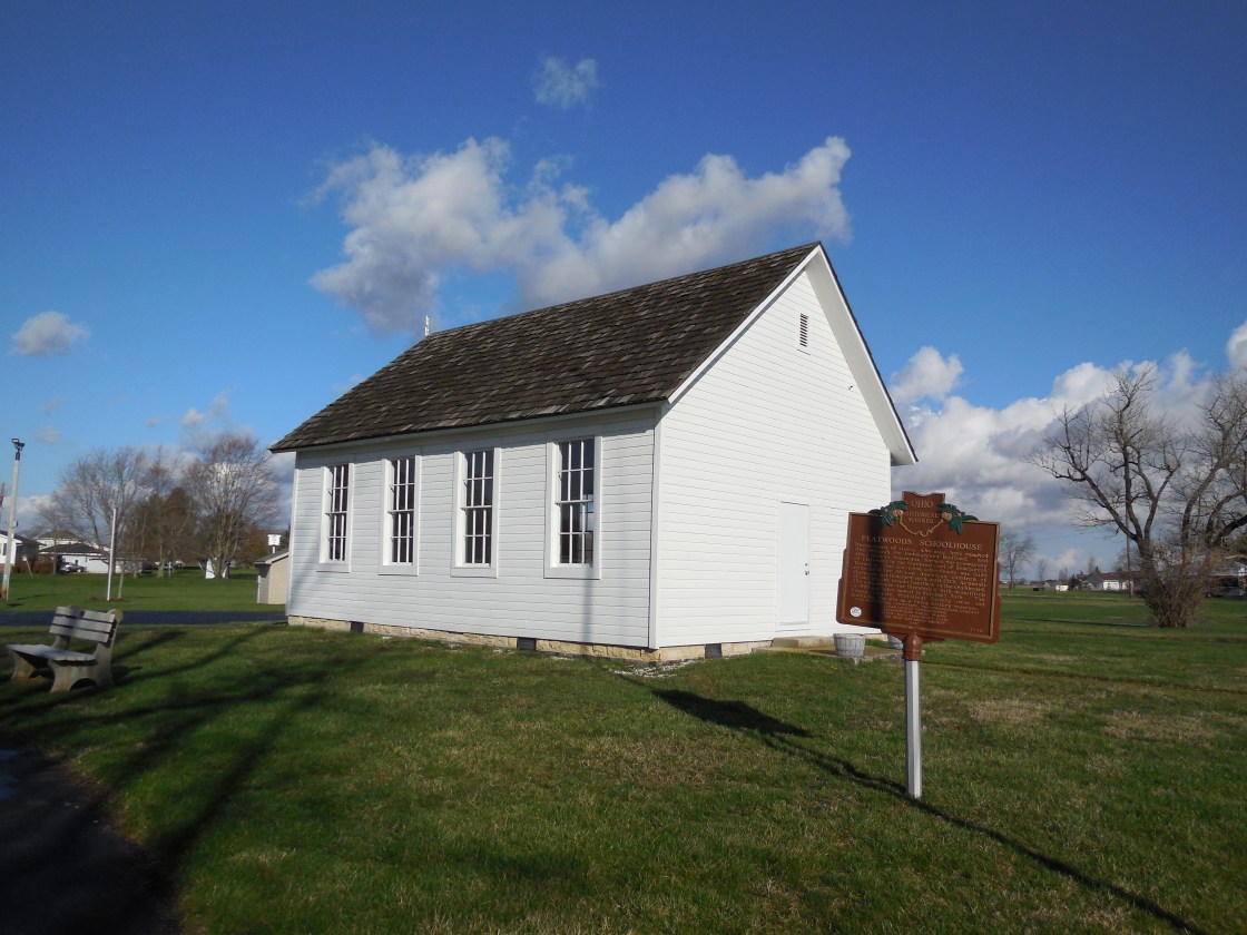
Flatwoods (Flat Woods) – Bokescreek Township
Location: 40.440427, -83.594420
on SR 292 (Hamilton St) at the intersection of Co Rd 119
Remnants: former one-room schoolhouse in Veterans Park at the intersection of Main St and Lake Ave in West Mansfield
Description: Flatwoods was an African American settlement founded in 1854 by Christopher Williams (1822 – 1872). A Baptist meeting house in the northwest corner of the intersection and a school on the south side of County Rd 119 were constructed around 1864. Solomon Day Jr. (1841 – 1883) was one of the first teachers. A frame church was built next to the school in 1879 and was used by the town’s Baptist and Methodist congregations. Christopher Williams and Solomon Day Jr. were buried with relatives and residents of Flatwoods in Day Cemetery about 5 miles southwest of the GPS coordinates on the south side of T-127 between Co Rd 12 and Township Rd 126 in Jefferson Township. The cemetery was established in 1842 on land owned by Solomon Day Sr. (1788 – 1855) from Virginia and Ann (Barnhill) Day (1801 – 1872) from Pennsylvania. The school closed in 1923, was moved to its present location while facing potential demolition in 1999, and has a historical marker with more info.
Gest
Location: unknown
Description: none found
Hooleys (Yoder) – Liberty Township
Location: 40.295882, -83.770012
on T-188 at the intersection of Township Hwy 249
Remnants: McKees Creek Church at 4750 US 68, McCraken Cemetery on private property on the west side of Township Rd 32 S north of McKees Creek, old houses and farms in the area
Description: It’s unclear exactly when the town went by its 2 different names, but it was along the Cincinnati, Sandusky, & Cleveland Railroad. There was an older church structure listed in the 1875 county atlas at the site of current-day McKees Creek Chapel. A school (Liberty Township No. 4) was on a 68-acre farm northwest of the GPS coordinates between T-188 and US 68 near the present end of Virginia Dr. David K. Hooley (1843 – 1904) and Phoebe (Hartzler) Hooley (1845 – 1901) owned the farm during publication of the 1890 county atlas. By that time, the Yoder family accumulated over 1,200 acres of land spread throughout the township. Some early residents were buried in McCraken Cemetery north of McKees Creek. Although it is on private property, the cemetery is well taken care of and access can be obtained. David and Phoebe Hooley were buried with relatives in Fairview Cemetery 3 miles south of the GPS coordinates on the west side of US 68 in West Liberty. The Yoders had a huge family and hundreds of descendants. Many were buried in Fairview Cemetery and Yoder Cemetery 3 miles west of the GPS coordinates on the west side of County Rd 1 between E – T190 and E – T30.
Howell (North Alexandria) (White Town) – Rushcreek Township
Post Office: 1830 – 1845
Location: 40.504153, -83.694889
on US 68 at the intersection of SR 273
Remnants: Miami Cemetery 2 miles southeast of the GPS coordinates at the intersection of Township Rd 51 E (T-51) and Co Rd 5
Description: The proprietors of the post office were Israel Howell from New York and Elizabeth (Hill) Howell who were married in Logan County in 1826. Israel was also former justice of the peace. William White platted North Alexandria at the location in 1832. It was often referred to as White Town. John Fry and Felt Bowers both ran general stores and the town had a log schoolhouse. We were unable to find extensive genealogy records on the town’s main residents. They were likely buried with currently unreadable gravestones along with their relatives in Miami Cemetery. John Deerwester Sr. laid out the cemetery in 1832 and ironically became the first interment. Over 20 of the residents buried in the cemetery reportedly perished from “milk sickness”, obtained by drinking milk from cows that were eating a poisonous weed called white snakeroot. The numbers of affected citizens in the state and Midwest were reduced as the land became better cultivated. One of the most famous people to perish from the same poisoning was Abraham Lincoln’s mother, Nancy (Hanks) Lincoln, in 1818.
Mackachack – Monroe Township
Location: 40.249554, -83.728794
on T-47 (Township Rd 47) along Macochee Creek south of SR 245 (Baird St)
Remnants: historical marker on the grounds of Mac-A-Cheek Castle
Description: This Shawnee Native American town was partially on the grounds of Mac-A-Cheek Castle and had a council house. Famed frontiersman and war veteran Simon Kenton (1755 – 1836) was forced to run the “gauntlet” 9 times while in captivity, including one at Mackachack in 1778. The town was later destroyed by a detachment of the Kentucky Militia on October 6, 1786 led by General Benjamin Logan (1742 – 1802). Some of the Native American artifacts put on display by Abram Sanders Piatt (1821 – 1908) in Mac-A-Cheek Castle were acquired from remains left by the Shawnees of Mackachack.
Mark – Stokes Township
Post Office: 1859 – 1865
Location: 40.459562, -83.993705
on Co Hwy 23 between Robinson Rd (Co Rd 225) and Myers Rd
Remnants: none known
Description: The town was founded by Adam Franks (1821 – 1909) from Columbiana County and Rhoda (Page) Franks (1825 – 1892) from New York. They were married in 1841, had 4 children, and a 160-acre farm. Adam was a carpenter, served in the Ohio Volunteer Infantry, and was the town’s postmaster. The Franks moved around a lot, living at various times in Illinois, Iowa, and Tennessee, but ended up back in Ohio. Mark had a school (Stokes Township No. 8) north of the GPS coordinates on the east side of Co Hwy 23 on land owned by the Powell family and a Methodist Episcopal church in the southwest corner of the intersection of Co Hwy 23 and Myers Rd. Adam and Rhoda Franks were buried with relatives in Plum Cemetery 6 miles southeast of town on the north side of Co Rd 54 between C-60 and SR 235 in Washington Township, Shelby County.
McKees Town – Liberty Township
Location: unknown
Description: It was a Native American trading post town along McKees Creek about 4 miles south of Bellefontaine. The proprietor was British immigrant Alexander McKee.
Mount Tabor – Washington Township
Location: 40.392393, -83.909607
on SR 235 at the intersection of C-13 (County Rd 13)
Remnants: Mount Tabor Church on the south side of C-13 east of the GPS coordinates, old houses and farms in the area
Description: Mount Tabor was a farming town that revolved around the church and had a school on the north side of T-215 (Township Hwy 215) off of SR 235.
Muchinippi (Muchinnipe) – Bloomfield Township
Post Office: 1840 – 1872
Location: 40.439282, -83.946173
on SR 274 at the intersection of C-21 (Co Hwy 21) along Muchinippi Creek
Remnants: Muchinippi Christian Church at the GPS coordinates, old houses and farms in the area
Description: This is another former farming town centered around its church. The first church was constructed in the mid-1850s on land owned by Martin Pence (1800 – 1859) from Shenandoah County, Virginia and Rebecca (Higgenbotham) Pence (1817 – 1883) from Brown County. They were married in 1842 after Martin’s first wife Susannah (Maggart) Pence (1802 – 1840) passed away. The Pence family cemetery was established in the lot on the east side of the church and has since been lost to time. The gravestones of Martin and Susannah were found on the farm to the east laying up against a tree and are listed on Find A Grave. The current church structure was remodeled in 1998. The town’s post office was called Muchinnipe. Joseph Wright (1790 – 1854) from Fairfield County was the first postmaster. Moses Smith (1819 – 1899) from Pickaway County took on the position after Joseph passed away and held the office for its last 18 years. Rebecca Pence, Joseph Wright, and Moses Smith were buried with relatives and other residents in Plum Cemetery 2 miles southeast of the GPS coordinates on the north side of Co Rd 54.
Read’s Town
Location: unknown
Description: It was a Native American town near Bellefontaine that had a few cabins around the year 1800.
Solomonstown (Solomon’s Town) – Richland Township
Location: 40.522417, -83.746420
on C-106 along Liggitt Ditch between Wilson Rd (Township Rd 210) and N State St (Co Rd 102)
Description: It was a Native American Wyandot (Wyandotte) town on the west side of the GPS coordinates. Chief Tarhe “The Crane” (1742 – 1818) resided at Solomonstown for a while. More of his story can be found in the listings in some of the other counties. The land was later purchased by the Liggitt family.
Tharps Run – Jefferson Township
Location: 40.323510, -83.694362
on Mt Crest Dr (Mountcrest Dr) between County Rd 5 N and Co Rd 55
Remnants: Tharps Run Cemetery at the GPS coordinates
Description: The town was founded by William Tharp (1779 – 1853) and Mary (Epley) Tharp (1794 – 1878) from Union County. They moved to Ohio from New Jersey, had a few children, and owned the farm on the south side of Mt Crest Dr across from the cemetery. A Baptist congretation formed in 1819, first meeting in a log chapel. They constructed a 30 x 40 feet brick church next to the cemetery in 1845. It was on land owned by Lewis Crouse (1816 – 1884) from Pennsylvania and Elizabeth (Kaylor) Crouse (1825 – 1903). They were buried with relatives in Mt. Zion Cemetery at the intersection of C-55 (Co Rd 55) and T-182 (Township Hwy 182) west of the GPS coordinates. William and Mary Tharp were buried with relatives in Tharps Run Cemetery. The Cleveland, Lorain, & Wheeling Railroad arrived in the area in the late 1800s, but it was too late to make any impact on Tharps Run.
Thatchersville – Miami Township
Location: 40.304185, -83.913452
on SR 508 (S Main St) at the intersection of C-63
Remnants: none known
Description: Thatchersville was a small plat on the south side of De Graff. Samuel Thatcher (1829 – 1885) from Virginia moved to the area in 1870 and built a steam-powered saw mill with a lumberyard in the vicinity of the intersection. His brother Henry Thatcher (1843 – 1915) born in Greene County joined the business in 1877. Thatchersville was listed in the 1875 county atlas and was annexed into De Graff prior to publication of the 1890 county atlas. Samuel and Henry were buried with relatives in Greenwood Cemetery a mile north of the GPS coordinates on the west side of SR 235 (Cretcher Ave).
Turner
Location: unknown
Description: none found
Mac-O-Chee, OH – (1870s – present castle town)
Classification: small town
Location: Monroe Township, Logan County – Mac-A-Cheek Castle is at 10051 Township Rd 47 just south of SR 245 and Mac-O-Chee Castle is on County Rd 1 north of the intersection of SR 287
The Piatt Castles in Logan County were built by the sons of Judge Benjamin Piatt (1779 – 1863) and Elizabeth (Barnett) Piatt (1780 – 1867). Both of them were started in 1864. Abram Sanders Piatt (1821 – 1908) constructed Mac-A-Cheek Castle which was completed in 1871. His brother Donn Piatt (1819 – 1881) built Mac-O-Chee and it was finished in 1879. Abram was a politician, poet, and farmer and Donn was a journalist and poet.
They accumulated large collections of oddities and interesting artifacts from around the area and displayed them in the castles. The surrounding town had a post office from 1881 – 1888. The Piatts were buried in Mac-A-Cheek Cemetery on Township Rd 47 about 3/10 of a mile south of the castle. Tours were started by family descendants in 1912 and still continue to this day.
Castles Website – http://piattcastles.org/Home.html