
Albion
Location: unknown
Description: It was listed in The Ohio Gazetteer and Traveler’s Guide from 1837 – 1841 as a village in the county.
Belfast
Location: unknown
Description: Belfast was listed in the 1876 Centennial History of Licking County, Ohio as a “virtually extinct village”.
Blanchard (Blanchard Settlement) – Granville Township
Location: 40.109554, -82.518590
on SR 661 (North St) at the intersection of Cambria Mill Rd
Remnants: former one-room schoolhouse on the east side of SR 661 about 1/2 of a mile south of the GPS coordinates, old farm buildings in the area
Description: The town was founded by Joseph Blanchard (1770 – 1859) and Nancy (Waite) Blanchard (1772 – 1851). They were born in Massachusetts, had several children, and moved to Ohio from Maine in 1818. Joseph and his 4 sons owned a wagon shop and built other wooden necessities such as spinning wheels and chairs. Blanchard had a school (Granville Township No. 8) on the west side of SR 661 on land owned by the Gates family prior to its last school built on the east side of SR 661 which is now a private residence. Joseph and Nancy were buried with relatives in Old Colony Burying Ground on S Main St in Granville. The cemetery is an impressive site to explore with many early county pioneers and war veterans laid to rest there.
Bowling Green – Madison Township
Location: unknown
Description: It was along the Licking River approximately 5 miles east of Newark and had a church.
Canonsburgh – Newton Township
Location: unknown
Description: Canonsburgh was about 3 miles north of Newark on the south bank of Dry Creek (formerly part of Brushy Fork).
Central City – City of Heath (formerly in Licking Township)
Location: 40.034677, -82.470716
on the railroad junction east of Keller Dr and south of Faye Dr NE
Remnants: none known
Description: Central City was at the junction of the Pittsburgh, Cincinnati, Chicago, & St. Louis Railroad and the Toledo & Ohio Central Railroad in the late 1800s to early 1900s.
Cook Settlement (Appleton) – Bennington Township
Location: 40.209282, -82.616680
on Appleton Rd at the 4-way intersection of Van Fossen Rd (Township Hwy 4) and Cooper Rd NW (Township Hwy 60)
Remnants: none known
Description: Cook Settlement was established around 1815 and preceded Appleton as a village. It was founded by War of 1812 veteran Captain Isaac Cook (1780 – 1856) and Titus Knox (1784 – 1866). The village served as a stopping point in the southern portion of the township for traveling settlers. Some stayed and some moved on. Titus Knox and Carey Mead platted Appleton next to the site of Cook Settlement in 1832. They named it after Appleton Downer who was a successful lawyer from Zanesville and owned much of the land in the township during its early years. Appleton didn’t get any population booms and was never a large town, but continues to maintain its existence. It also has a few stories of the past to tell, which are quietly held in the walls of some of the old buildings around town as well as in the county history books. Isaac Cook was buried in Chestnut Grove Cemetery on Grove Dr in Ashtabula, Ashtabula County. Titus Knox was laid to rest in Sunbury Memorial Park on West Cherry St in Sunbury, Delaware County.
Cox
Post Office: 1859 – 1861
Location: unknown
Description: none found
Denmans Cross Roads (Cooksey) (Reform) – Perry Township
Post Office: 1880 – 1889
Location: 40.137859, -82.250263
on Reform Rd NE (Co Hwy 232) at the intersection of Mary Ann Furnace Rd (Township Hwy 243) along Brushy Fork
Remnants: Smith Chapel and Cemetery a mile south of the GPS coordinates at the intersection of Reform Rd NE and Montgomery Rd NE (Township Hwy 243A), old houses and farm buildings in the area
Description: The original proprietors were Zenas Denman (1791 – 1871) from Sussex County, New Jersey and Jane (Smith) Denman (1799 – 1874) from Frederick County, Virginia. They were married in 1816, had a nice farm, and several children. Although the family was living at the crossroads for several decades, the town wasn’t listed on a map by its name until the 1875 county atlas. It was mentioned in the 1881 county history book and had a general store, blacksmith shop, and a shoe shop at the time. The store opened in 1857 and was owned by Lucius Hoyt (1835 – 1910) and Isabella (Denman) Hoyt (1841 – 1896), a daughter of Zenas and Jane. In the 1880s, the town also went by the name Cooksey, matching the post office in the store with Lucius being the postmaster. After the post office closed, the town started going by the name of Reform around 1900. Zenas and Jane were buried with relatives in Hanover Cemetery 5 miles south of town on the north side of Rock Haven Rd NE. Lucius and Isabella were buried with relatives and other early residents in Smith Chapel Cemetery. The church is still in operation and Reform is a currently populated place which pops up on Google Maps.
Etniers (National Road Station) (Atherton) – Licking Township
Location: 39.960337, -82.437697
Post Office: 1884 – 1925
on US 40 (National Rd SE) at the intersection of Lancer Rd SE
Remnants: former train station on the north side of the GPS coordinates
Description: Founded by the Etnier family in the county, the town had a post station on a pony express line running along the National Road in 1836 – 1837. Mail was run by 2 carriers through this portion of Ohio, one from Zanesville to Etniers and the other from Etniers to Columbus with fresh hoses spread out every 5 miles. Sometime between publication of the 1854 county map and 1866 county atlas, Simeon Etnier (1814 – 1881) from Pennsylvania, enlarged the family farm from its previous 60 acres to 260 acres on the southeast side of the GPS coordinates. The Hocking Valley Railway (later the Newark, Somerset, & Straitsville Railroad and eventually the B&O) rolled through the area for many decades. The former train station was called National Road and is now a private residence with the T. J. Evans Recreational Trail starting there and heading north on the previous railroad bed. After Simeon’s death, the town started going by the name of Atherton and had a regular post office. The first postmaster was James Oliver Davis (1841 – 1902). He was succeeded by a son, John Franklin Davis (1869 – 1939). They were buried with relatives in Fairmount Cemetery about 3 miles east of the GPS coordinates at the intersection of US 40 and Fairmount Rd. Atherton still a populated place and is listed on Google Maps. Simeon was buried with relatives in Jacksontown Cemetery 2 miles northeast of the GPS coordinates on the east side of SR 13 (Jacksontown Rd).
Exeter
Location: unknown
Description: Exeter was listed in the 1876 Centennial History of Licking County, Ohio as a “virtually extinct village”.
Green (Raccoon Town) – Monroe Township
Post Office: 1857 – 1893
Location: 40.181015, -82.742417
on SR 37 (Johnstown – Alexandria Rd) at the intersection of Downing Rd (Township Hwy 45)
Remnants: former school on the south side of the intersection
Description: The proprietors were brothers from Virginia, George Green (1779 – 1862) and Charles Green, who were the first settlers in the area. They purchased what was Raccoon Town along Raccoon Creek from a group of Wyandot Native Americans in 1807. Early pioneer Elizabeth (Barler) Kasson (1799 – 1868) from Shenandoah County, Virginia was the first postmaster. She married Daniel Kasson (1801 – 1884) from Luzerne County, Pennsylvania in 1819 and had 11 children. Daniel Tippet (1813 – 1883) from Maryland was the next postmaster. His wife Elizabeth Tippett (1820 – 1899) took on the position after Daniel passed away. The former school on the south side of the GPS coordinates was pinpointed in the 1875 county atlas and was constructed on land owned by James Hill (1853 – 1871). It’s currently a private residence. Everyone mentioned in this listing was buried in Green Hill Cemetery 3 miles southeast of the GPS coordinates on the south side of SR 37.
Idlewild Park (Idlewilde Park) – City of Heath and City of Newark
Location: 40.042504, -82.432835
on S 21st St at the intersection of Idlewilde Ave
Remnants: old houses in the area
Description: Idlewilde Park was on the grounds of Newark Earthworks. James F. Lingafelter (1859 – 1924) leased the site from the Licking County Agricultural Society and opened an amusement park called Idlewilde Park in 1898. Over the years, the park contained a theater, dance pavilion, bowling alley, a Ferris wheel, roller coaster, and several other attractions. It became a resort with a hotel and restaurant along with 4 ponds for boating and swimming. The park had a stop on the Newark Consolidated Electric Railway interurban line, which also connected to Buckeye Lake Amusement Park about 9 miles to the south. James Lingafelter was guilty of shady business dealings and was prosecuted for forgery and embezzlement. The park went into new management and the name changed to Rigel Park. It couldn’t compete with Buckeye Lake Park though and eventually closed. The agricultural society deeded the site to the county in 1927 and the county deeded it to the Ohio Historical Society in 1933. The state historical society restored the earthworks as much as possible. It became a National Historic Landmark in 1964. James Lingafelter was buried with relatives in Wilson Cemetery on SR 657 (Marion Rd NE) on the north side of Newark.
Kibler
Location: unknown
Description: It was named after a branch of the Kibler family in the county.
Livingston (Levingston) – Hanover Township
Location: 40.060065, -82.262330
on the south side of the southern end of Rockhaven Rd SE (Township Hwy 275A) between the railroad tracks and the Licking River just east of Rocky Fork
Remnants: none known
Description: Listed as Levingston on the 1854 county map, it had a small cluster of houses on both sides of the Ohio & Erie Canal and got passed up by the Ohio Central Railroad which was on the south side of the Licking River. The town wasn’t pinpointed in the 1866 or 1875 county atlases. Its final literary appearance was in the 1876 Centennial History of Licking County, Ohio as a “virtually extinct village”. Although we haven’t found the genealogical link yet, it was likely named after a branch of the Livingston or Levinston families in the county.
Thanks to Larry Gorley for providing the location info on Livingston!
Lockport – City of Newark (formerly in Newark Township)
Location: 40.053821, -82.418690
on West Main St at the intersection of Union St
Remnants: none known
Description: Lockport was platted along the Ohio & Erie Canal in 1830 by former county surveyor James Holmes Jr. (1785 – 1848) from Pennsylvania and Corrington Searle (1790 – 1865) from Connecticut who was the mayor of Newark in 1829. It was named after the town’s canal locks, had a school, mill, and grocery store, and was also on the Pittsburgh, Cincinnati, Chicago, & St. Louis Railroad. Lockport still appeared on maps as a separate town in the early 1900s, but was eventually annexed into Newark. James Holmes Jr. was buried with relatives about 9 1/2 miles southwest of the GPS coordinates in Luray Cemetery on the south side of Refugee Rd SW. Corrington Searle was buried with relatives in Woodlawn Cemetery on Pershing Rd in Zanesville, Muskingum County.
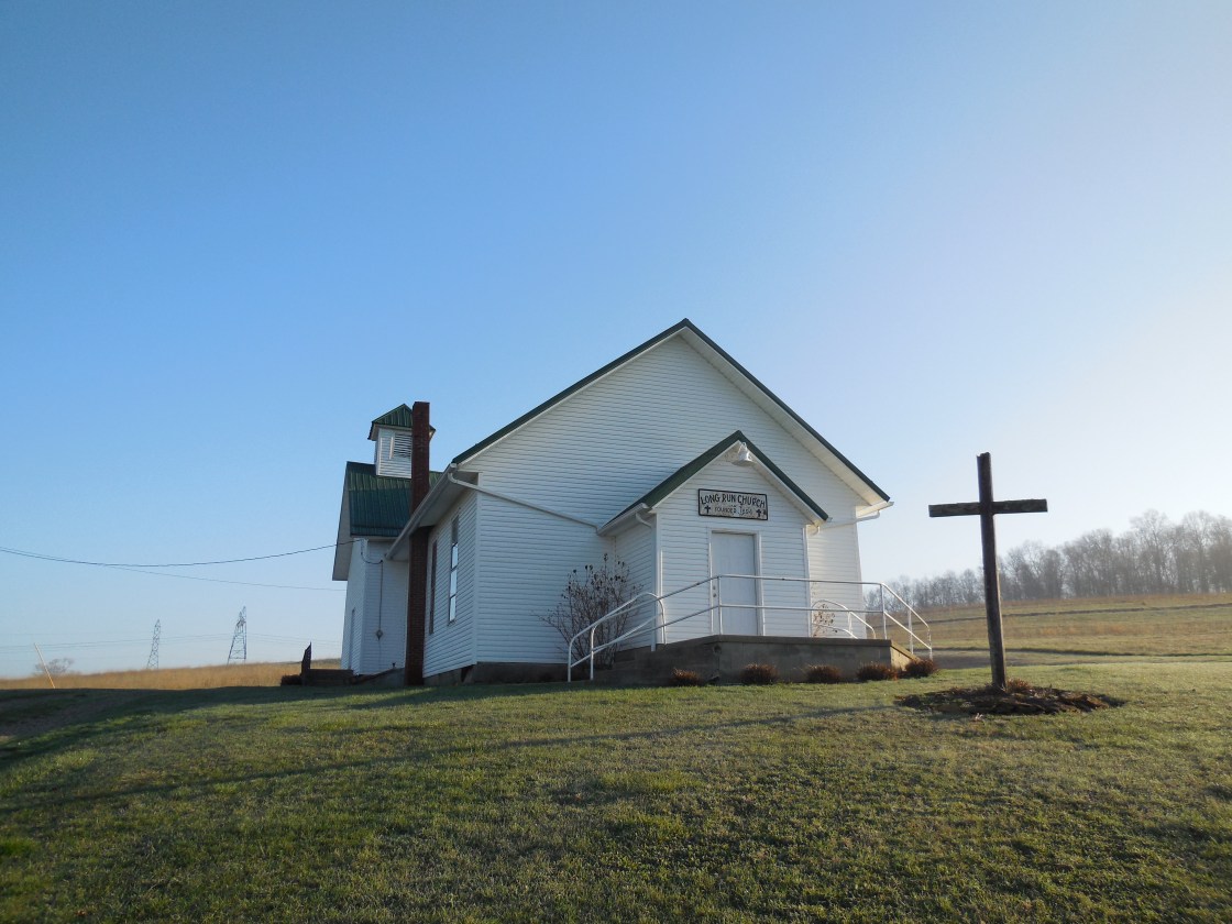
Long Run (Longrun) – Eden and Fallsbury Township
Post Office: 1858 – 1904
Location: 40.206696, -82.285343
on Long Run Rd at the intersection of Rain Rock Road Northeast (Co Hwy 244) along Long Run
Remnants: Long Run Church in the northwest lot of the intersection, old farm buildings in the area
Description: The proprietors were neighbors who lived across the intersection from each other. John J. Edwards (1831 – 1907) and Julia Ann Edwards (1833 – 1863) owned a 110-acre farm on the north side of the intersection and donated land for Long Run Church in the mid-1850s. Julia tragically died just 4 days after the death of her last child, having at least 2 sons who departed this world before her as toddlers. Early pioneers James Wilson Colville (1795 – 1878) and Leah (Baker) Colville (1800 – 1886) owned a 156-acre farm on the south side of the intersection. They were both born in Virginia, married in Ohio in 1827, and had at least 8 children. James was the town’s first postmaster. The Edwards and Colville families were buried in Souslin Cemetery 2 miles southwest of town on the west side of Baker Rd NE. Elza Dush was the second postmaster and Charles Baker was the town’s last postmaster.
Maryann (Mary Ann Furnace) – Mary Ann Township
Location: 40.118779, -82.286637
on Hickman Rd NE at the intersection of Montgomery Rd NE (Township Hwy 243) along Rocky Fork
Remnants: none known
Description: David Moore from Pennsylvania arrived in Licking County in 1808. He operated a general store in Newark was the postmaster there from 1809 – 1818. David already had the idea of smelting iron in the future when he built a saw mill along Rocky Fork in 1815. The following year, he began construction of a cold blast furnace and a grist mill to accommodate workers and residents. David invited the few neighbors there was back in those days to celebrate the completion of the furnace, which he named after his wife at the time. War of 1812 veteran Abraham Claypool Wilson (1776 – 1830) christened the furnace in with the flinging of a whiskey bottle against its side and later that year the newly formed township went with the name of Mary Ann as well. The town surrounded the intersection and was home to dozens of workers who held jobs in various industries related to the furnace operations. The furnace switched to steam in 1847 and continued operating for several more years. One of the main goods produced with the quality iron was Mary Ann Stoves which were extremely popular in the early to mid-1800s and used to heat hundreds of buildings such as schools, bars, churches, and some homes. Pots, pans, and kettles were a few of the smaller items produced with the furnace’s iron. Unfortunately, the genealogy on the Moore family is sketchy, to put it mildly, and we must skip over to avoid passing on any incorrect info.
Morus Hill – Fallsbury Township
Post Office: 1842 – 1849
Location: unknown
Description: Joseph Mather was the town’s first postmaster. He was succeeded by Abraham D. Larason (1814 – 1886). Abraham was buried with relatives in Martinsburg Presbyterian Cemetery on US 62 (N Market St) in Martinsburg in Clay Township, Knox County.
Moscow – Union Township
Location: 39.961115, -82.464050
on US 40 (National Rd) at the intersection of Mill Dam Rd
Remnants: none known
Description: Moscow was platted in 1830 by Daniel Green (1791 – 1857) from Allegany County, Maryland and one of his brothers, William Green (1799 – 1855). They were sons of the first settlers in the county, Revolutionary War veteran Benjamin Green (1755 – 1833) and Catharine (Beem) Green (1760 – 1821), who arrived in the area in 1800. Moscow’s plat was in the southwest side of the GPS coordinates between Mill Dam Rd and South Fork Licking River. Daniel built a grist mill around the time Moscow was founded and later built a saw mill. The town was last listed by its name in the 1866 county atlas and was described as “nearly passed away” in the 1881 county history book. Daniel was buried with his parents, wife Elizabeth (Pitzer) Green (1796 – 1860) also born in Allegany County, Maryland, and other relatives in Beard – Green Cemetery about 4 miles northeast of town in Dawes Arboretum. William’s first wife was Sarah (Pitzer) Green (1804 – 1828). She was born in Ohio, a sister of Daniel’s wife Elizabeth, and was also buried in Beard – Green Cemetery. William moved out of Ohio and was buried with relatives, including his second wife Eliza (Brown ) Green (1808 – 1865), in Rochester Cemetery on Cemetery Rd off of SR 38 in Cedar County, Iowa.
Mount Hope (Mt. Hope) – Bowling Green Township
Location: 39.954438, -82.312151
on US 40 (National Rd) at the intersection of Mt. Hope Rd
Remnants: old houses and farm buildings in the area
Description: It grew up with the string of towns along the National Rd and was listed as a platted town in the 1854 county atlas. The plat was in the northeast corner of a 126-acre farm owned by Benjamin Orr (1799 – 1855) from Fayette County, Pennsylvania and Sarah (Dusthimer) Orr (1800 – 1887) from Loudon County, Virginia. Mount Hope later lost its status as a town and was mentioned as a “virtually extinct village” in the 1876 Centennial History of Licking County, Ohio. However, the community continued to go by the same name for several more years as it was about halfway between Linville and Brownsville. Benjamin and Sarah had at least 5 children and were buried with relatives 4 miles west of town in Fairmount Cemetery at the intersection of US 40 and Fairmount Rd.
New Winchester
Location: unknown
Description: The town was listed in the 1876 Centennial History of Licking County, Ohio as a “virtually extinct village”.
Oberlin – Eden Township
Location: 40.229004, -82.334669
on Purity Rd NE (Co Hwy 209) at the intersection of Camp Ohio Rd (Co Hwy 210) along Rocky Fork
Remnants: old houses and farm buildings in the area
Description: James Shannon (1810 – 1899) and Summerfield (Priest) Shannon (1812 -1897) founded Oberlin around 1856 when they opened a general store next to Rocky Fork near the intersection. James was a butcher by trade and also tried to get a post office in the store, but that never happened. Letters were unofficially left there for resident to pick up though. The store went into new ownership a few times, was destroyed by fire in 1880, and subsequently rebuilt. Oberlin also had a small grist mill and a blacksmith shop. James and Summerfield had at least 6 children and were buried with relatives 5 miles southeast of the GPS coordinates in Souslin Cemetery on the west side of Baker Rd NE.
Rowville – Franklin Township
Post Office: 1860 – 1862
Location: unknown
Description: It was in the northwest portion of the township with Jacob J. Row (1839 – 1896) as postmaster. He was buried with relatives in Franklin Township (Saint John Church) Lutheran Cemetery on Linville Rd SE along Swamp Run between Cotterman Rd SE (Township Hwy 301) and Flint Ridge Rd (Co Hwy 312).
Fallsburg, OH (Fallsburgh) – (1839 – present mill and farming town with little growth)
Classification: small town
Location: Fallsbury Township, Licking County – On SR 79 at the intersection of SR 586 (Pleasant Valley Rd)
The area was first settled by Tomas Meek (1799 – 1864) who opened a blacksmith shop sometime around 1840. He is probably buried in Meek Cemetery on the south side of McDonald Rd, about 7/10 of a mile east of SR 79. Minor McQueen (1785 – 1867) and Sarah (Normam) McQueen arrived next. They were buried in Fallsburg Cemetery on Church St off of SR 79 along with several members of their family. The town of Fallsburg was never laid out or platted, but most of it was built on land that was owned by Silas Bland (1799 – 1882) and Harriet (Cooksey) Bland (1808 – 1886). They were both buried in Perryton Cemetery on Pinewood Trail Rd off of SR 586, about 5 miles south of town.
In its early days, Fallsburg also had a saloon, grocery store, shoe shop, and the first Baptist church was built in 1835. The post office ran from 1839 – 1907 and dropped the “h” from the town name in 1892. A saw mill was constructed around 1840 next to the Wakatomica Creek and later purchased by William Harrison Gregg (1827 – 1901) and Mary Jane (Hull) Gregg (1833 – 1920). They added a grist mill and in 1881 a covered bridge was built on the east section of Frampton Rd off of SR 586 to make crossing the creek easier. It was rebuilt after an arson fire by teenagers in the 1950s. Today it goes by the names of Greggs Mill or Handel Covered Bridge. The last school in Fallsburg was constructed in 1938 but now sits abandoned on SR 586, just a couple of buildings to the south of SR 79. There are also some members of the Meek family and other early families from the area buried in Fallsburg Cemetery on Church St.
Fleatown, OH (Hog Run) – (early 1800s to late 1800s farming town partially abandoned over time)
Classification: small town
Location: Licking Township, Licking County – On Jacksontown Rd (SR 13) at the intersection of White Chapel Rd
This small town was originally named Hog Run, due to the fact that hogs from local farms would run away to the area at certain times of the year because of a large abundance of beech nuts and acorns. One of the hogs was owned by John Ward (1816 – 1895), who most of the locals started to call “Hog” Ward. Some of the other hogs were owned by Issac Stadden (1770 – 1841) and his wife Catherine (Kleiber) Stadden (1780 – 1870).
On the Stadden’s land was said to be orchards planted by Johnny “Appleseed” Chapman (1774 – 1845) as he had passed through and reportedly did some planting while he was there. Catherine Stadden firmly denied this. She brought three apple tree saplings from Pennsylvania when her family made the move to Hog Run and claimed that most of the orchards in the Licking Valley were from her good trees and seeds. Catherine bitterly disliked Johnny Appleseed and called his trees “shabby saplings”. Many historians however discount her statements and still claim that Johnny did the majority of the planting on the Stadden’s land.
Hog run later got the name of Fleatown when a traveler stayed a night and said that’s what it should be called. It was never incorporated though and didn’t have a post office. Fleatown’s Friendship Church was organized in 1811 and many of the residents were buried in Fleatown (Friendship) Cemetery at the southeast corner of SR 13 and White Chapel Rd. Issac and Catherine Stadden were buried at Bowling Green Cemetery on Marne Rd off of SR 16 on the east side of Newark.
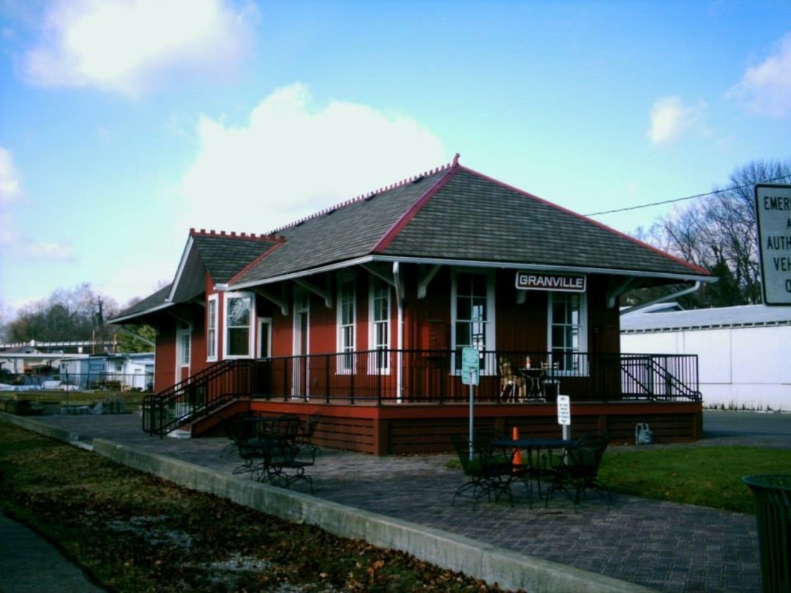
Granville, OH (1805 – present farming, mill, railroad, and university town with numerous historical sites)
Classification: historic town
Location: Granville Township, Licking County – On SR 661 at the intersection of County Hwy 539
In 1804 residents from Granville and Granby, Massachusetts formed The Licking Company and purchased over 29,000 acres of land in Ohio. Around 150 or so of them arrived in Licking County in 1805 and immediately began platting the town with a total of 288 lots and plans for the community buildings that they would need.
In 1812 Orrin Granger (1788 – 1822) built a tavern and inn which also served as a stagecoach stop between Columbus and Newark. It was purchased in 1865 by Major Horton Buxton (1821 – 1902), a veteran of the Civil War. Major Buxton owned the inn until his death and it still carries his name to this day. Everyone from presidents and celebrities to regular common folks have enjoyed the inn and drank in its downstairs tavern for over 2 centuries. The Buxton Inn is currently the longest continually operated hotel in Ohio.
One of the other famous owners was Ethel “Bonnie” Bounell (1888 – 1960) was a dancer, singer, and entertainer. She operated the inn from 1934 – 1960. Her cat was named “Major” after Major Buxton. It’s still said to appear around the inn by the workers and visitors. Ethel Bounell and Major Buxton are also reported to still hang out there. Ethel is referred to as “The Lady In Blue”, for often wandering around in a blue dress. She reportedly passed away in room #9.
In 1972 Orville and Audrey Orr purchased The Buxton Inn after they heard it might be demolished. They restored the buildings over the last few decades and we had the privilege of speaking with Orville for a while, who we unexpectedly met in the restaurant room on the main floor. He was quietly sitting by himself reading the paper, and after greeting us in a friendly manner, Orville proceeded to tell us several of his own stories about the inn. It was an awesome experience and we give unending credit to Orville and Audrey for their love of The Buxton Inn and its history. It has since been sold and is under new management.
Granville had population booms with the building of Denison University in 1831, a large grain mill, and the railroad. Many of the 1800s buildings on the side streets and secondary roads in town survived and are now on the National Register of Historic Places. The train station from the Toledo & Ohio Central Railroad was built in 1880. It has been restored and sits at 425 South Main St (SR 661). Granville’s mill is still in operation and runs a general store across from the train station.
The Granville Inn, across the road from The Buxton Inn, was completed in 1924 and is also reportedly haunted. Ohio Historical Marker #23 – 45 at the intersection of Broadway and Main St (SR 661 and County Hwy 539) tells the story of The Licking Company and early settlers. Another neat Ohio Historical Marker is #21 – 45 on South Main St next to The Old Colony Burying Ground where most of the early settlers of Granville were buried. The town is a great trip for anyone who would like to spend a few hours or even a day or two visiting many different historical locations.
Buxton Inn Website – https://www.buxtoninn.com/
Homer, OH (Burlington) – (1816 – present farming and business town with fluctuating periods of growth)
Classification: small town
Location: Burlington Township, Licking County – On Homer Rd
Homer was laid out in 1816 by John Chonner (1776 – 1853) and Mary Chonner (1775 – 1854). The town was originally named Burlington, but that changed when the post office was established to avoid confusion with the township name. There wasn’t much in the area at the time except for a few log cabins built by early residents of the township. The only roads through town were old hunting and trapping trails that were blazed by natives of the Shawnee, Wyandot, and Delaware tribes. Several mounds and earthworks attributed to the ancient Adena tribe were discovered in Homer’s vicinity, and a “giant” skeleton was found in a creek bank that was excavated in 1824. The local natives stated they knew about the earthworks, but had no other knowledge of the ancient tribe which had long since disappeared.
John Chonner was a veteran of the War of 1812 and enlisted in the Ohio Militia, serving as a 2nd Corporal in a mounted company. After the war, he constructed the first saw mill and first brick house in Burlington Township and also kept busy with farming. In 1823 Owen Owens, who was a preacher from the Welsh Hills Church on Hog Run, established the first church congregation in Homer. Services were held in log cabins and log schoolhouses. Later that same year, James Houck (1873 – 1883) expanded the town’s west side with plots of his farm up for sale for more residents and businesses. Unfortunately James lost a son, his house, and his farm was ravished by “The Burlington Storm”, a horrendous tornado that rolled through town in 1825. Many other homes, farms, and orchards were destroyed and several lives were sadly lost. Homer grew well in the 1820s – 1840s and had all the imaginable nostalgic charm of a small Ohio town of that era. There was a tavern, 3 hotels, a tannery, 2 physicians, a dry goods store, blacksmith and other small merchant shops.
The 1872 Presidential Election put Homer in the national spotlight with the first woman to run for the office. Victoria (Claflin) Woodhull (1838 – 1927), an early women’s suffrage leader and first woman along with her sister Tennessee to open a brokerage firm on Wall Street. Victoria was nominated by the Equal Rights Party. She lost the race against incumbent Republican Ulysses S. Grant and Liberal Republican Horace Greeley, but did receive some votes.
Although it was a bustling community in the mid to late 1800s, Homer suffered a bit of a setback having failed to attract a canal or railroad to create a major population increase. It lagged behind while other towns in the county like Granville and Utica were booming. Factories with good manufacturing jobs in some of the larger towns drew residents away from Homer. Some of the local farms were also struggling to keep up with advances in agricultural machinery. The town’s population in they heyday of the 1880s was around 300 with 2 hotels, 2 blacksmiths, a large school, wagon and cabinet shop, 3 churches, and 2 dry goods stores.
In the 1890s, Homer seemed to be spiraling downhill, but the discovery of local natural gas led to progress in the early 1900s and the hopeful sentiment, “There is gas at Homer”. The Ohio Fuel Supply Company ran pipes from fields in West Virginia to a station in Homer and a main pipe to consumers all the way in Cincinnati. The jobs created a small boom in town and also helped keep other small businesses running in the 1900s.
These days, the Columbia Gas Transmission company still operates in Homer. School #2 built in 1909 and #3 built in 1950 stood on Homer Rd. Both closed in 2008 and were demolished in 2019. There are several houses that were built in the 1800s around town and a few abandoned homes and businesses. It’s not as busy as it once was, but Homer has proud residents with a past that’s definitely rich in history. John and Mary Chonner were buried in Homer Cemetery on Homer Rd, a large cemetery for a small town, along with James Houck, his family, and many other early settlers and families.

Lock, OH – (1837 – present farming town with less residents than in the past)
Classification: semi-ghost town
Location: Bennington Township, Licking County and Milford Township, Knox County – On Lock Rd at the intersection of SR 657 (Marion Rd NW)
Lock was settled by Isham Abbott (1799 – 1859) and Lois (Everett) Abbott (1807 – ?) in 1836. Isham had a potash business and laid out lots for the town in 1837, naming it Lock for unknown reasons. A post office was established in 1838 at his store and Lock got its first church in 1845. The Abbotts later moved out of town and Lock didn’t grow much over the next few decades without a canal or railroad, although it was still the biggest town in the area.
Washington Hildreth (1829 – 1903) was the most prominent business man in Lock during the late 1800s. He was the last postmaster in town and a member of the Ohio National Guard. An atlas from 1871 shows that Hildreth owned 2 stores, a warehouse, and several lots in town, including Hildreth’s Hall where members of the Order of Good Templars held meetings. Around that time, Lock also had another store, a cooper shop, 3 churches, a school, wagon shop, blacksmith, harness shop, and a shoe shop. The 1870s appear to be the peak of Lock’s heyday and the community has been dwindling since then.
The last general store in town, which was built on one of Washington Hildreth’s lots, still stands at the intersection of Lock Rd and SR 657. A Congregational Church constructed in 1844 is across the street. There’s also an old Methodist Church on Lock Rd east of the center of town. Washington Hildreth and many other early residents were buried in Lock Cemetery south of town on SR 657.

