
Arcole (Harper’s Landing) (Ellesnburg) (Madison Dock) (Mascot) – Madison Township
Post Office: 1837 – 1851, 1839 – 1841, and 1898 – 1899
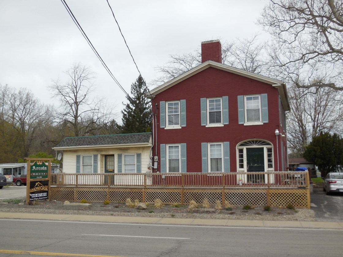
Location: 41.821723, -81.015847
on Dock Rd between US 20 and Lake Erie along Arcola Creek
Remnants: Dock Road Cemetery on the east side of the GPS coordinates, Arcola House 1 1/2 miles south of the GPS coordinates in the northwest corner of the intersection of US 20 and Dock Rd
Description: The area was originally called Harper’s Landing, named after Revolutionary War veteran Colonel Alexander Harper (1744 – 1798) from Middlesex County, Connecticut and Elizabeth (Bartholomew) Harper (1749 – 1833) from Hunterdon County, New Jersey. They were a couple of the earliest pioneers in the Western Reserve and founded the nearby town of Hapersfield in Ashtabula County. The Arcola House was built around 1806 and served as an inn for tired travelers. It’s the only structure left that has witnessed the the areas remarkable changes since the early 1800s. On top of ship building and fishing, Arcole had 2 iron furnaces called The Arcole Steam Hot And Cold-Blast Charcoal Furnaces. The first one was built in the mid-1820s by Root & Wheeler of the Erie Furnace Company and the second was built by Wilkeson & Co. in 1832. The Arcole Iron Works produced stoves, kettles, and several other heavy castings in the foundry. It was once the largest employer in the state. The furnaces and foundry were along Arcola Creek south of the GPS coordinates with a post office from 1837 – 1851. Charles F. Swan was its first postmaster and was succeeded by John W. McGinnis. Ellensburg was platted near the northern end of Dock Rd at Lake Erie as the docking point for incoming supplies and shipping out finished products. It had a post office from 1839 – 1841 and was also known as Madison Dock. On the 1857 county map, a school was pinpointed on the east side of Dock Rd in section 14 and another one was in section 3 on the north side of US 20 just west of the Arcola House. There was also a grist mill on the east side of Dock Rd along Arcola Creek just north of US 20. The grist mill and school near the Arcola house (Madison Township No. 3) were still in operation by publication of the 1898 county atlas. A newer school (Madison Township No. 2) in the northeast corner of the intersection of Dock Rd and Cunningham Rd replaced the former one to the north in section 14. The last name taken on by the area in the 1800s was Mascot, pinpointed in the 1901 George Cram atlas, with a post office from 1898 – 1899. Charlie W. Barrett (1859 – 1923) was its only known postmaster. He was laid to rest with relatives in Mount Pleasant Cemetery on SR 84 (South Ridge Rd E) in Geneva, Ashtabula County. Dock Road Cemetery isn’t very large, but it contains interments of many early residents.
Clarks – Concord Township
Location: 41.650046, -81.241490
on SR 44 between Girdled Rd and Capital Pkwy
Remnants: none known
Description: Clarks sat along the Pittsburgh & Western Railroad (later bought by the B&O). It had a school (Condord Township No. 7) southwest of the GPS coordinates on the north side of Girdled Rd just west of Auburn Rd on land donated by the Woodruff family.
Hampshire – Concord Township
Post Office: 1842 – 1843
Location: unknown
Description: It was listed in the 1843 A Table Of Post-Offices In Ohio, Arranged By Counties, Townships, And Towns as being 3 miles from Painesville.
Heisley (Heisley Station) – City of Mentor (formerly in Mentor Township)
Location: 41.697267, -81.307327
on Heisley Rd at the railroad crossing between Hamilton Dr and Tyler Blvd
Remnants: none known
Description: Heisley had a train station on the Lake Shore & Michigan Southern Railway. These days, a business zone on the southeast side of the GPS coordinates called Heisley Road Commerce Park and a residential subdivision to its northeast still use the former town’s name.
Hobarts Corners – City of Kirtland (formerly in Kirtland Township)
Location: 41.583910, -81.369054
on US 6 at the intersection of Hobart Rd
Remnants: none known
Description: It was founded by Joshua Hobart (1809 – 1892) and Lucy (Heath) Hobart (1814 – 1893). They moved to Ohio from New Hampshire and had at least one child. The town had a school on the south side of US 6 just west of Hobart Rd. Joshua and Lucy were buried with relatives in Waite Hill Village Cemetery on Waite Hill Rd 3 miles north of the intersection.
Hopkins (Hopkins Point) – City of Mentor (formerly in Mentor Township)
Location: 41.720486, -81.342134
on SR 283 (Lakeshore Blvd) at the intersection of Hopkins Rd
Remnants: none known
Description: The town was founded by Daniel Hopkins (1790 – 1867) from Vermont and Anna (Churchill) Hopkins (1804 – 1898) from New Hampshire. They got married in Ohio in 1820, had 11 children, and owned a 500-acre farm. The New York, Chicago, & St. Louis Railroad rolled through the area in the late 1800s to early 1900s. Daniel and Anna were buried with relatives in Mentor Municipal Cemetery at 7881 Hopkins Rd south of the intersection.
Judds Corners – Concord Township
Location: 41.661620, -81.196514
on SR 608 (Concord Hambden Rd) at the intersection of Girdled Rd
Remnants: none known
Description: Its proprietors were Samuel Judd (1792 – 1875) and Marcia (Welton) Judd (1795 – 1872) who moved to Ohio from Connecticut and had a few children. Samuel was the postmaster of the Concord office in 1852. They were buried with relatives in Welton Cemetery on Goodwin Rd in Burton, Geauga County. Justin N. Day (1812 – 1876) and Abigail (Briggs) Day (1816 – 1892) moved to Ohio from New York and owned a cabinet shop on the south side of Girdled Rd northeast of the GPS coordinates. They were laid to rest with relatives in Evergreen Cemetery on Main St in Painesville.
Kniffins Corners (Breakman) – Leroy Township
Post Office: 1890 – 1901
Location: 41.659667, -81.129540
on SR 86 (Painesville Warren Rd) at the intersection of Kniffen Rd
Remnants: Brakeman (Peters) Cemetery on the north side of SR 86 between Kniffen Rd and Brakeman Rd, South Leroy Meeting House in the southwest corner of the intersection of SR 86 and Brakeman Rd, old houses and farm buildings in the area
Description: Kniffins Corners and Proctor Corners are ghost towns within the current populated place of Breakman which is listed on Google Maps. We will try to get it all sorted out here as chronologically and cartographically as possible. South Leroy Meeting House, a Methodist church, was constructed from 1822 – 1832 by Henry Brakeman (1785 – 1869) from New York and his sons at what would become Breakman Corners at the intersection of SR 86 and Brakeman Rd. There were a couple of local blacksmiths in the mid-1800s. A grist mill and saw mill with a lumber yard was along Bates Creek at what would later become Proctor Corners at the intersection of SR 86 and Leroy Thompson Rd (County Hwy 203). They were owned by Otis A. Warner Sr. (1800 – 1885) and employed many residents. Hill House (Hillhouse) post office was originally at Kniffins Corners and moved to Leroy Center. In the mid-1800s to early 1900s, there were 2 local schools along SR 86, Leroy Township No. 1 at Breakman Corners and Leroy Township No. 7 at Proctor Corners. Sometime prior to publication of the 1898 county atlas, the Kniffin family moved to the area with brother and sister George W. Kniffin (born c. 1855) and Allie B. Kniffin (born c. 1860) owning around a combined 200 acres of land on the north side of SR 86 at the GPS coordinates. During that time period, Breakman Corners was was still centered around the intersection of SR 86 and Brakeman Rd. It had a post office from 1890 – 1901. Most of the Warner farm was bought by Edward Proctor (1841 – 1916), turning that area into Proctor Corners before 1900. Breakman ended up absorbing both Kiffins and Proctor while its center shifted further east in the mid-1900s. South Leroy Meeting House was added to the National Register of Historic Places in 1979. A restoration consisting of new siding and a fresh coat of paint began in 2015 and has since been completed. Henry Brakeman and Otis Warner Sr. were buried with relatives in Brakeman (Peters) Cemetery. Edward Proctor was laid to rest with relatives in Maple Grove Cemetery about 4 3/4 miles northeast of the GPS coordinates on the south side of Leroy Thompson Rd in Thompson Township, Geauga County. The burial locations of George and Allie Kniffin are unknown. Their family surname was spelled as Kniffen in some branches and in certain historical records.
Marsh Settlement – City of Mentor (formerly Mentor Township)
Location: 41.725800, -81.338800
on Harbor Dr in the Mentor Marina
Remnants: historical marker at the GPS coordinates
Description: It was platted in 1797 by Charles Parker of the Connecticut Land Company as the first settlement in Lake County. Mentor grew out of the settlement.
New Market (Skinner’s Landing) – Painesville Township
Location: 41.740973, -81.260103
on Skinner Ave at the intersection of N St Clair St along the Grand River
Remnants: none known
Description: The town was platted in 1803 by Revolutionary War veteran Captain Abraham Skinner (1755 – 1826) from Connecticut, who also founded and platted Fairport. In 1788 he married Mary (Ayers) Skinner (d. 1812) and had 5 children. They moved to New Market with Abraham in 1805 after he returned to Connecticut to get them. The town had 3 warehouses, a general store, 2 taverns, and a distillery, but was abandoned as other towns in the area were growing much more rapidly. Abraham and Mary were buried with relatives in Evergreen Cemetery on Main St in Painesville.
Pease Mill – Concord Township
Location: 41.668845, -81.183901
on Girdled Rd at the intersection of Cascade Rd along Big Creek
Remnants: none known
Description: It was founded in 1852 by David Pease (1815 – 1890) from Massachusetts and Lucy (Dean) Pease (1817 – 1857). David built a mill on Big Creek for turning wood to make furniture and small wares, selling items at fairs and expos in local towns and big cities to increase its profit. He also planted a maple and walnut grove in Pease Hollow to replenish the trees he used. The mill collapsed due to heavy snows in 1963. David remarried after his first wife passed away and was buried with relatives in Evergreen Cemetery on Main St in Painesville.
Rush Road – City of Willowick (formerly in Willoughby Township)
Location: 41.621437, -81.457893
on E 305th St (formerly Rush Rd) at the railroad crossing between US 20 (Euclid Ave) and N Marginal Dr
Remnants: none known
Description: The town was on the Lake Shore & Michigan Southern Railway and was named after the family of Richard Rush (1847 – 1919) and Ella (Gould) Rush (1857 – 1949) who owned land on Rush Rd and had a few children. They were buried with relatives in S.O.M. Road Cemetery in Willoughby Hills.
Wheeler (Trumbulls Mills) – Madison Township
Post Office: 1834 – 1838 and 1889 – 1900
Location: 41.735035, -81.045272
on SR 528 (S Madison Rd) at the intersection of Griswold Rd
Remnants: none known
Description: Wheeler was originally called Trumbulls Mills and had a grist mill and saw mill on the south side of the Grand River owned by the Trumbull family in the early to mid-1800s. The mill site was in what is currently Hidden Valley Park on Klassen Rd. The post office called Trumbulls Mills operated from 1834 – 1838 with John Ransom serving as postmaster. A school was on the north side of River Rd between SR 528 and Bailey Rd. There was also a cheese factory at the mill site which was pinpointed in the 1874 county atlas. The mills were sold several times over the passing decades of the 1800s and the school from the mid-1800s was replaced with a newer one (Madison Township No. 6) at the same location. Edward P. Wheeler was the first postmaster of the Wheeler office. He was succeeded by Harriet (Marsh) Sparks (1846 – 1919). Harriet was buried with relatives in Fairview Memorial Park 2 miles north of the GPS coordinates on the east side of SR 528.
Worden – City of Wickliffe (formerly in Willoughby Township)
Location: 41.621324, -81.475000
on Worden Rd at the intersection of Elgin Rd
Remnants: none known
Description: The town was founded by Noah Worden (1778 – 1864) from Connecticut who moved to Ohio in 1809. He had 7 children and remarried after his first wife passed away. It was a farming town and had a school in the mid-1800s. Noah was buried with relatives in Willoughby Village Cemetery on Sharpe Ave.

