
Clinton – Morris and Clinton Township
Post Office: 1810 – 1819
Location: 40.412894, -82.499002
on SR 13 (Cassell Rd) along the Kokosing River between Green Valley Rd and Crestview Dr
Remnants: none known
Description: It was founded in 1804 by Samuel Hoy Smith (1776 – 1862) from New York and had hopes of eventually becoming the county seat. The town was platted along what was then called Owl Creek, now the Kokosing River. Samuel opened a general store in 1807, a hotel, tavern, tannery, was the first postmaster, the first surveyor of Knox County and was a Freemason. Clinton was growing well with businesses and residences, better than Mount Vernon in every imaginable way. As the story goes, a panel of 3 commissioners were appointed in 1808 to decide what town should be named the seat. Clinton and Mount Vernon were the 2 towns at the top of the short list. The residents of both towns knew the commissioners were on their way to visit. When the panel arrived in Mount Vernon, its were busily engaged in working and showing off their town in a respectful manner. As the commissioners left to check out Clinton, some of the residents of Mount Vernon quickly took to the side trails and made it to Clinton before the commissioners. They were intentionally rude, rowdy, and disrespectful while the panel was in Clinton, and the seat was subsequently awarded to Mount Vernon. However, it wasn’t until after the close of the War of 1812 that Mount Vernon surpassed Clinton in being a better town. Despite the loss of the seat, Clinton continued to thrive for a few years. The town was home to the first post office established in the county, the first church, and the first printing press which ran a newspaper and printed the first books. Clinton also had a chair factory, several stores, hotels, tanneries, and a mill. The loss of seat was a continual problem though and Clinton kept declining in stature until its legal existence was terminated in 1818. There were around 30 residences remaining at the time. Samuel later moved to Texas and was buried there with relatives in Farrsville Cemetery on the west side of FM 1415 north of TX-63 in Newton County.
Cornish – Monroe Township
Location: 40.422829, -82.382021
on Cornish Rd along Schenck Creek between Vincent Rd and Monroe Mills Rd
Remnants: none known
Description: Bishop Philander Chase (1775 – 1852) was born in Cornish City, New Hampshire, a town founded by his father. After living in a few other states, Philander purchased 8,000 acres of land in Knox County. He founded Kenyon College on the land in 1824. On the undeveloped 4,000-acre half, Philander laid out Cornish in 1829 and named it after his hometown. It appears to have only been a town on paper though and none of the lots were ever sold. Philander moved to Michigan for a few years and then went on to Illinois where he founded Jubillee College in 1838. He was buried with relatives in Jubillee Cemetery on W Jubillee College Rd in Peoria County, Illinois.
Darlings (Owl Creek) – Butler Township
Post Office: 1816 – 1845
Location: 40.372892, -82.224731
on Staats Rd (Township Hwy 200) at the intersection of Busenberg Rd along the Kokosing River
Remnants: none known
Description: The proprietors were Abraham Darling (1780 – 1871) from Bedford County, Virginia and Rhoda (Shrimplin) Darling (1787 – 1865) from Maryland. Abraham moved to Ohio in 1806 with his father, Revolutionary War veteran William Darling (b. 1756) in Virginia. Abraham and Rhoda were married in 1824, owned a farm on the northeast side of the GPS coordinates between Staats Rd and the river, and had 14 children. Abraham was the postmaster. The town was never platted and didn’t have any population booms. Abraham and Harriet moved to Fulton County, Illinois where they were buried in Hart (Beatty / Clay) Cemetery on the north side of US 24 west of Cardinal Ln.
Fleaville (Fleaville City) – Pleasant Township and City of Mount Vernon
Location: 40.388141, -82.463894
on SR 229 (Gambier Rd) at the intersection of S Edgewood Rd along Center Run
Remnants: none known
Description: Its main industry was a brewery in the southwest corner of the intersection where a Baptist church presently stands. The brewery was established in 1835 by Jacob Kurtz. It was last spotted in the 1871 county atlas with John Bechtol (1817 – 1880) from France and Margaret (Artner) Bechtol (1832 – 1908) as the owners. Fleaville made it into the 1896 county atlas, but fell off of maps shortly after that. John was buried with relatives in Calvary Cemetery on Mansfield Ave in Mount Vernon.
Front Royal – Jackson Township
Location: 40.298719, -82.261775
on Front Royal Rd (County Rd 61) at the intersection of Kerr Rd
Remnants: none known
Description: Front Royal was platted in 1831 as the first village in Jackson Township and had a general store, blacksmith shop, and a school. It was abandoned by the residents in the mid-1800s after discovering that the title to the land that the lots were on wasn’t good. The area subsequently reverted back to farmland.
Genoa Station – Jefferson Township
Location: unknown
Description: The only reference to the town was found in the 1877 Geology Of Knox County.
Hains (Haines) (Ten Mile Settlement) – City of Mount Vernon (formerly in Clinton Township)
Location: 40.364847, -82.479759
on SR 13 (Neward Rd) at the intersection of Glen Rd
Remnants: none known
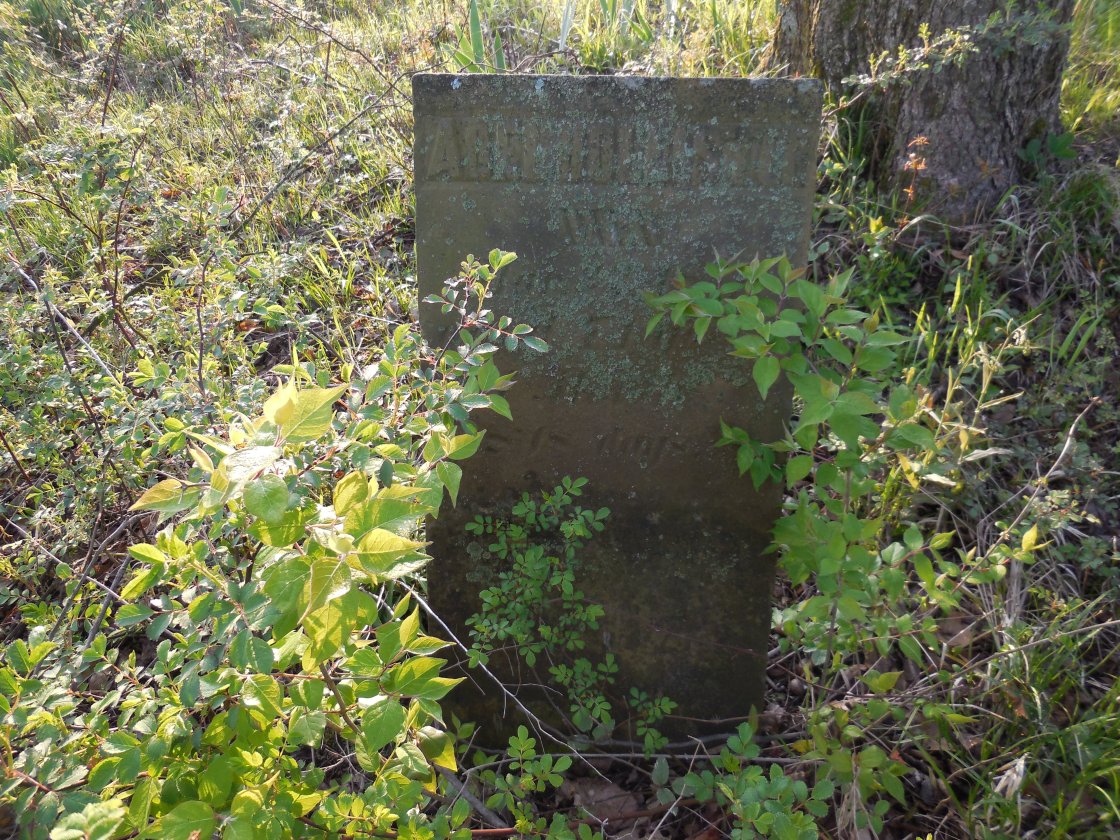
Description: This farming and mill town was founded by settlers from Ten Mile in Washington County, Pennsylvania. The first grist mill in the county was constructed in the settlement by Ebenezer and Abner Brown in 1804 with the help of the neighborhood. Henry Hains also arrived around that time with his family. He served as the first county treasurer from 1808 – 1815 and the town took on the Hains name. Although the area was never abandoned, the town itself didn’t last long. Henry reportedly battled with temporary insanity several times during his life and was found dead in 1817 by a self-inflicted hanging. There are accounts of some of his strange behavior in the county history books, including the day of his demise. Sadly, if living in modern times, he likely would have been diagnosed with schizophrenia.
Harrison
Location: unknown
Description: Harrison was platted 1816 by Jacob Lepley (1777 – 1861) from Somerset County, Pennsylvania and Susan (Critchfield) Lepley (1784 – 1869). They were married in 1800 and had a few children. Jacob served as a justice of the peace in Union Township in 1809 and a judge in Jackson Township in 1815. There’s no record of any of the lots in Harrison having been sold. Jacob and Susan moved to Holmes County and later Coshocton County where they were buried with relatives in Monroe Cemetery on the south side of Township Rd 130 between Co Rd 132 and Township Hwy 324 in Monroe Township.
Hollisters (Zuck) – Butler Township
Location: 40.383321, -82.248024
on Zuck Rd (Township Hwy 201) along the Kokosing River between SR 715 and Staats Rd (Township Hwy 200)
Remnants: Hollister Cemetery at the GPS coordinates
Description: Hollisters distantly preceded Zuck as a town, which had a post office at the same location from 1880 – 1903. Abel Hollister Jr. (1771 – 1847) from Litchfield County, Connecticut and Aranah (Terrill) Hollister moved to the area in the early 1800s and had several children. Abel was buried with relatives and other residents in the cemetery. His father was a Revolutionary War veteran. The cemetery has what was once a very nice stone wall with a small iron gate, but time and nature are now taking their toll. The last known interment was in 1861. Zuck is still listed as a populated place but the old town is gone. It was named after Stephen Zuck, one of the owners of a grist mill and saw mill complex called Green Valley Mills on the north side of Owl Creek, now the Kokosing River. The town also had a general store and the population in 1900 was around 40 residents. The post office closed due to lack of use though and the Great Flood of 1913 wiped out the remaining businesses and residences.
Houcks – Hilliar Township
Location: 40.293408, -82.724348
on US 36 (Columbus Rd) at the intersection of Dill Rd (Township Hwy 102)
Remnants: Houck Cemetery at the GPS coordinates
Description: It was the first settlement in Hilliar Township and was founded by James Houck (1783 – 1883) and Sarah (Shadley) Houck (1784 – 1863), Jacob Houck (1787 – 1850) and Rhoda (Jennings) Houck (b. 1786), along with the family of Joseph Jennings. Jacob and James were brothers. Their father, Revolutionary War veteran William Houck (1753 – 1836) from Maryland, built the first blacksmith shop in the township on Jacob’s farm. The building was used for the town’s school after he retired. Jacob ran a tavern in the settlement, served as township recorder, justice of the peace, and platted Centerburg in 1817. James was a township trustee, treasurer, and donated land for the cemetery and a new log school in 1823. William and Jacob were buried with relatives in Houck Cemetery. James and Sarah were buried with relatives in Homer Cemetery in Licking County about 12 miles southeast of town on the north side of Homer Rd NW.
Magnetic Springs – Morris Township
Location: unknown
Description: It was 2 miles north of Mount Vernon. The town name always refers to a natural spring in the area with large amounts of mineral content.
Maple Grove – Berlin Township
Post Office: 1849 – 1860
Location: 40.527098, -82.524976
on Roberts Rd (Township Hwy 379) between Yankee St and Quaker Rd
Remnants: none known
Description: The proprietors were county pioneers Richard Roberts (1789 – 1877) from Frederick County, Maryland and Sarah (Garrison) Roberts from New York (1796 – 1872). They had 10 children, 9 daughters and a son. Richard was the postmaster and enjoyed talking about the state’s early days, especially in evenings around the fireplace in the family’s old cabin during winter. Richard and Sarah were buried with relatives in Quaker (Friends) Cemetery about 2 1/2 miles southwest of the GPS coordinates at the intersection of Zolman Rd (County Rd 69) and Friends Ln in Middlebury Township.
New Lexington
Location: unknown
Description: It was platted by Robert Griffin in 1816.
Pleasant Valley (Pleasant Grove) – Brown Township
Location: 40.490080, -82.352806
on SR 3 (Wooster Rd) along Little Jelloway Creek at the 4-way intersection of Nunda Rd and Apple Valley Rd
Remnants: none known
Description: Pleasant Valley has a saw mill next to Little Jelloway Creek in the 1860s – 1870s on land owned by John A. Feaster. A school (Brown Township No. 8) was north of the GPS coordinates at the intersection of SR 3 and Sapps Run Rd.
Rossville (Rosstown) – Union Township
Post Office: 1878 – 1882
Location: 40.441793, -82.260778
on US 62 at the intersection of Flat Run Rd (County Rd 40)
Remnants: Workman Cemetery south of the intersection on the west side of US 62
Description: The town was platted just south of Danville in 1871 by Jacob Ross (1825 – 1906) and Nancy (Workman) Ross (1826 – 1901), around the time when the railroad arrived in the area. It rapidly grew and attracted all of the imaginable businesses of the era with well over 200 citizens. The plat of Buckeye City was squeezed between Danville and Rossville by J. C. Tilton in 1880. This statement appeared in the 1881 county history book. “The three villages will, no doubt, in course of time be consolidated.” The prediction turned into fact in 1923 when Rossville and Buckeye City were annexed by Danville. However, as fate would have it, Rossville fell off of the maps but Buckeye City still retains its identity as a named neighborhood of Danville. Workman Cemetery was established on land formerly owned by Nancy Ross’s parents. Jacob and Nancy had 6 children and were buried with relatives in the cemetery.
Wolfes (Wolf) – Harrison Township
Post Office: 1844 – 1863
Location: 40.339954, -82.358157
on Hopewell Rd at the intersection of Grove Church Rd (County Rd 31)
Remnants: Union Grove Cemetery on the east side of Grove Church Rd just north of the GPS coordinates, old houses and farm buildings in the area
Description: The Wolfe family is of German descent and arrived in the county in the early 1800s. George Wolf was the first postmaster and held the office until the late 1850s. Simon Bonnet was his only known successor. The office was listed as Wolf in postal records. Union Grove Cemetery was established around 1823 and the original Disciple log church was built in 1832 on land owned by Nathaniel Ross (1794 – 1882) and Sarah (Hair) Ross (1794 – 1868). They got married in 1817, moved to Ohio from Greene County, Pennsylvania, and had 8 children. A wood frame church replaced the log structure in 1841 and there was a school on the south side of Hopewell Rd east of the GPS coordinates. After surviving the “Burlington Storm” in May of 1825, a destructive tornado that caused much damage to the Ross farm and countless others in the state, another tornado swept through the area on September 2, 1845. One of the Ross daughters, Rachel Ann (1822 – 1845), was instantly killed by a falling log. Some of the houses and farm buildings near the GPS coordinates date back to the town’s postal days. Nathaniel and Sarah Ross, along with Rachel Ann and other relatives, were buried in Union Grove Cemetery. There are over 80 known Wolfe family members buried in the cemetery and many more scattered throughout the county.
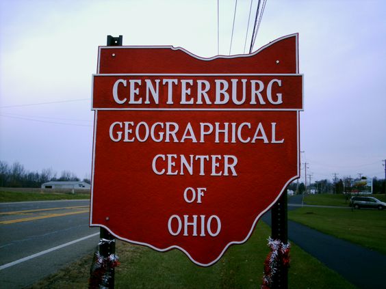
Centerburg, OH (1834 – present farming, mill, and railroad town at the geographical center of Ohio)
Classification: historic town
Location: Hilliar Township, Knox County – On US 36 at the intersection of County Rd 21
Centerburg was founded in 1834 and quickly grew to be the largest town in Hilliar Township. With its claim as being the geographical center of Ohio, Centerburg was one of the lucky towns that boomed with the railroad in the mid to late 1800s. There are several historical markers and “Geographical Center of Ohio” signs around town, as well as several historic buildings and locations. We happened to pass through there on one of our ghost town trips in 2013. The abandoned train station in the listing picture is next to US 36 on the southeast side of town. One of the geographical center of Ohio signs is along the roadside close to it.
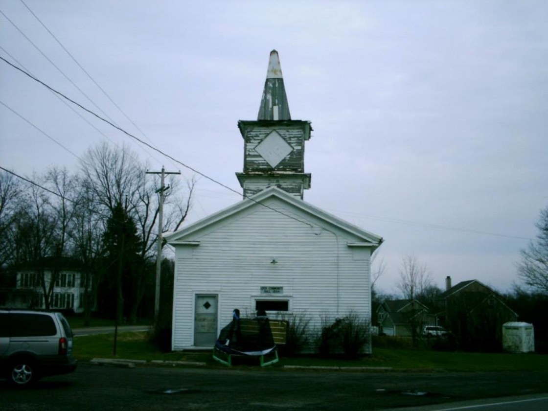
Lock, OH – (1837 – present farming town with less residents than in the past)
Classification: semi-ghost town
Location: Bennington Township, Licking County and Milford Township, Knox County – On Lock Rd at the intersection of SR 657 (Marion Rd NW)
Lock was settled by Isham Abbott (1799 – 1859) and Lois (Everett) Abbott (1807 – ?) in 1836. Isham had a potash business and laid out lots for the town in 1837, naming it Lock for unknown reasons. A post office was established in 1838 at his store and Lock got its first church in 1845. The Abbotts later moved out of town and Lock didn’t grow much over the next few decades without a canal or railroad, although it was still the biggest town in the area.
Washington Hildreth (1829 – 1903) was the most prominent business man in Lock during the late 1800s. He was the last postmaster in town and a member of the Ohio National Guard. An atlas from 1871 shows that Hildreth owned 2 stores, a warehouse, and several lots in town, including Hildreth’s Hall where members of the Order of Good Templars held meetings. Around that time, Lock also had another store, a cooper shop, 3 churches, a school, wagon shop, blacksmith, harness shop, and a shoe shop. The 1870s appear to be the peak of Lock’s heyday and the community has been dwindling since then.
The last general store in town, which was built on one of Washington Hildreth’s lots, still stands at the intersection of Lock Rd and SR 657. A Congregational Church constructed in 1844 is across the street. There’s also an old Methodist Church on Lock Rd east of the center of town. Washington Hildreth and many other early residents were buried in Lock Cemetery south of town on SR 657.

