
Abmac
Location: unknown
Description: It was on the Portsmouth Subdivision of the B&O Railroad between Hamden and Portsmouth in the early 1900s.
Bud – Jefferson Township
Post Office: 1888 – 1901
Location: unknown
Description: Bud was listed on the Ohio map in the 1901 George Cram atlas. It was in the northwest portion of Jefferson Township with William H. Brown serving as the postmaster.
Cambridge – Jefferson Township
Location: unknown
Description: none found
Coor – Liberty Township
Location: unknown
Description: It was on the Ohio Southern Railroad west of Simpsons.
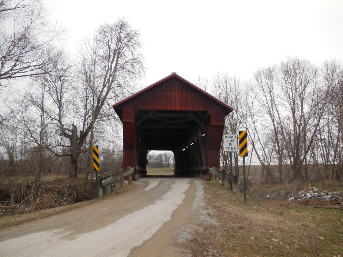
Crabtrees Mills – Scioto Township
Location: 38.964425, -82.777714
on Johnson Rd (Township Hwy 291) along the Little Scioto River between Spangenburg Rd and Crabtree Rd
Remnants: Providence Cemetery on Johnson Rd about 1/3 of a mile southwest of the GPS coordinates, Johnson Road (Crabtree) Covered Bridge about 1/3 of a mile southwest of the cemetery, old houses and farm buildings in the area
Description: The massive Crabtree family was one of the most well-known and prominent families in the county in the 1800s. A grist mill and saw mill constructed in 1823 next to the Little Scioto River by Colonel W. David Walton (1789 – 1850) from New Jersey was the first mill in the township. David sold the mill to Daniel White in 1829 and his family later became the first settlers of Cedar County, Iowa. Daniel sold the mill to William Crabtree (1804 – 1882) in 1834. The last owner was one of William’s sons, Enoch Crabtree (1824 – 1898). The mill was dismantled shortly after Enoch passed away. The Crabtrees were buried in Providence Cemetery which was officially established in 1867 and also had a church that was listed in the 1875 county atlas. Johnson Road Covered Bridge, also called Crabtree Covered Bridge, was built in 1869 – 1870 by Robert W. Smith who patented the Smith Truss that was used for its construction. The bridge was added to the National Register of Historic Places in 1984 and was restored in 2000.
Diamond Town – City of Jackson (formerly in Lick Township)
Location: 39.058435, -82.652295
on Main St at the intersection of Main Pl along Salt Lick Creek
Remnants: none known
Description: Construction of an iron furnace just south of Salt Lick Creek near the GPS coordinates began in 1854 and was completed in 1855 with production starting in January of the following year. It was originally called Salt Lick Furnace and ended as Diamond Furnace. The town had a general store, a warehouse, and was along the Hillsborough & Cincinnati Railroad (Hillsboro & Cincinnati). In 1861 at the outbreak of the Civil War, the site became a mustering and training grounds called Camp Diamond for the 53rd Ohio Volunteer Infantry Regiment. Diamond furnace was the first in the country to use stone coal for fuel, but was unsuccessful in producing quality iron from the idea. It closed in 1867 and the town’s land was eventually annexed by Jackson.
Eastburn – Liberty Township
Post Office: 1900 – 1904
Location: 39.104053, -82.755371
on Limerick Rd (Co Rd 25) along Pigeon Creek at the 4-way intersection of Big Rock Rd and McCune Cemetery Rd
Remnants: none known
Description: Eastburn was a small farming town with a school on the east side of Limerick Rd north of the GPS coordinates. James L. Vance (1845 – 1933) and Sarah (Hooten) Vance (1851 – 1933) owned a general store. Sarah was the town’s postmaster. They were buried with relatives 2 miles north of the intersection in Limerick Cemetery on the east side of Savageville Rd (Co Rd 26).
Eckny – Hamilton Township
Post Office: 1893 – 1902
Location: It was in the northeast portion of Hamilton Township with Joseph W. Davis serving as the postmaster.
Erie – City of Jackson (formerly in Lick Township)
Location: 39.049122, -82.618870
on Old US Hwy 35 between Triumph St and a dead end near US 35
Remnants: none known
Description: Erie was listed in the 1875 county atlas and had a plat around the GPS coordinates. The town had a small iron furnace owned by John H. Stephenson (1813 – 1877) from Virginia and Sarah (Shearer) Stephenson (1819 – 1905). They got married in 1840, had a few children, and were buried with relatives in Fairmount Cemetery about a mile north of the GPS coordinates on Fairmont St in Jackson.
Gee Town – Bloomfield Township
Location: 39.018956, -82.525833
on SR 327 at the intersection of Union Cemetery Rd along Dickason Run
Remnants: Gee Town (Union Cemetery) at the end of Union Cemetery Rd
Description: Gee Town was named after the Gee family that lived in the area in the mid to late 1800s. Most of the residents mined coal or worked at Keystone Furnace. We don’t have a lot of info on the place, other than it was instrumental in working with Keystone Furnace, but it can be found on Google Maps in a field that looks like it once harbored a town. Gee Town had a train station on the Cincinnati, Hamilton, & Dayton Railroad, transporting iron and coal from the Bloomfield and Ridgeland Mines. Gee Town Union Methodist Church was formed in 1842. Jacob Gee (1868 – 1946) and Daisy (Barlow) Gee (1882 – 1964) were the town’s longest residents. They were buried in the Gee Town (Union) Cemetery on Union Cemetery Rd off of SR 327 with their children. Jacob’s parents, Stephen (1845 – 1909) and Rosinda (Sheilds) Gee (1844 – 1926), along with his paternal grandfather Martin R. Gee (1820 – 1878) are buried in Keystone Cemetery off of Bain Perkins Rd east of town.
Green Meadow – Washington Township
Post Office: 1852 – 1856
Location: unknown
Description: County pioneer Thomas W. Leach (1797 – 1874) from Farquier County, Virginia was the postmaster. He married Nancy (Rose) Leach (1799 – 1878) in 1819 and had a few children. They were buried with relatives in Sigler Cemetery on the north side of Sigler Rd in Jefferson Township, Ross County.
Hewit (Hewitt) – Jefferson Township
Post Office: 1897 – 1902
Location: 38.903558, -82.637171
on SR 279 at the intersection of 4 Mile Rd (Co Rd 11) along Hewitt Run
Remnants: none known
Description: It was a small farming and postal town with coal and lead mines in the area. There was also a church with a separate Sunday school building across the road on SR 279 just west of Paul Crabtree Rd (Township Hwy 42) on land owned by Thomas T. Jones (1805 – 1883) and Mary (Edwards) Jones (1806 – 1871). They were born in Wales, married in 1826, and moved to the U.S. in 1838. John Morris (1857 – 1931) was the first postmaster. He was succeeded by Stephen Crabtree. Everyone mentioned so far in this listing was buried with relatives in Horeb Cemetery about 1 1/2 miles east of the GPS coordinates on the south side of SR 279. However, the origin of the town name, and that of the stream which runs through it, is a much more interesting story. They were named after the man who has since been dubbed “The Scioto Hermit”, War of 1812 veteran William Hewitt (1764 – 1834) who moved to the area from Virginia and resided near the GPS coordinates for about 10 years. William remained another 23 years in Jackson County, living in caves and rudimentary cabins. He relocated into his last residence close to the Pike and Ross County border near Alma in 1820, a cave in the Scioto Valley where he spent the last 14 years of his life. There are 3 separate accounts of why William ended up living the life of a hermit, each said to have been shared in confidence by Hewitt himself to 3 different people he associated with over the years. One account, recorded in the 1900 Jackson county history book, is William’s father passed away just before he moved to Ohio and his family fiercely fought over the estate. Either being left out of the dividing, disgusted by it, or a little bit of both, William basically decided to become a hermit and not be influenced at all by worldy possessions. Another account, recorded in the 1871 Ross county history book, is he was married, left to go on a hunting hike, and didn’t expect to return for several days. William went back home that same night, encountered another man with his wife on the couch in their house, and left Virginia heartbroken. The third account, also recorded in the 1900 Jackson county history book, is pretty much the same as the second with the additional unconfirmed fact of William killing the encountered suitor. Whatever the true case was, William was famous even during his lifetime for his hermitage, especially during his last 14 years in the Scioto Valley cave. He passed away from pneumonia in Waverly while on a trading trip and was buried there. It was by no means the end of William’s strange tale though. Dr. William Blackstone (1796 – 1879), who attended to the hermit’s illness preceding his death, later exhumed Hewitt’s bones to mount a portion of the skeleton. That would, of course, be crazy and illegal these days, but it was a common scientific practice for physicians in the 1800s, usually with corpses that had no family to object to it. The doctor buried the leftover bones on his lot. They were discovered by a cellar digger in 1852, Edward Vester (1822 – 1902), who reinterred them in another part of the lot. Edward forgot about the discovery and accidentally dug them up again in 1883. The story of the bones hit the print news. A few days later Dr. Thomas Blackstone (1847 – 1912) of Circleville in Pickaway County, a nephew of William Blackstone, sent a letter stating that he had in his possession what he believed to be William Hewitt’s mounted skeleton, acquired from his departed uncle’s estate. The dug up bones were sent to Thomas and ended up being a perfect match, finally reuniting the skeleton after 50 years. What happened to the majority of it since then is a mystery, but the skull had been passed around Circleville as a gift over the following 66 years. The Ross County Historical Society received the skull by donation in 1949 and has preserved it ever since. Ironically, a monument to William Hewitt has almost endured as much chaos as the skeleton. It was erected in 1842 on top of his cave along what was back then the newly laid Columbus & Scioto Turnpike. The monument was moved to the state highway garage in Chillicothe in 1952. The road, present day US 23 / SR 104, was subsequently widened to 4 traffic lanes and unfortunately destroyed what was left of the cave. From there, the monument went to the entrance of the Scioto Trail State Park at the intersection of US 23 and SR 372 (Stoney Creek Rd). It now sits at what will hopefully be its final resting place near a replica log church in the Scioto Trail State Park campground at Caldwell Lake. William Hewitt’s ghost has reportedly been spotted wandering around George Hollow Rd and along the trails in the state park, enjoying the solitude he so desperately sought.
Jimes – Madison Township
Post Office: 1861 – 1903
Location: 38.876237, -82.495058
on SR 279 between Jimes Emory Rd (Co Rd 49) and Flat Woods Rd
Remnants: none known
Description: This small farming and postal town had a general store on the north side of the GPS coordinates. It had several owners and postmasters over the decades.
Latrobe (Latrobe Furnace) – Milton Township
Location: 39.070293, -82.513973
on Camine Rd between SR 124 and an unnamed road
Remnants: none known
Description: Latrobe Furnace was built in 1854 and was owned by Bundy, Austin, & Company (later Bundy & Cobb). Hezekiah Sanford Bundy (1817 – 1895) from Marietta was the principal owner. He also served in the U.S. House Of Representatives and the state senate. The furnace was named after a French immigrant who supervised its construction. Harvey Wells (1846 – 1896), who founded Wellston, managed the town’s general store for a few years. It also had school and some houses for workers. Furnace production stopped in 1885. Hezekiah Bundy and Harvey Wells were buried with relatives in Ridgewood Cemetery about 5 1/2 miles north of the GPS coordinates on Massachusetts Ave in Wellston.
Leach – Jackson Township
Post Office: 1883 – 1903
Location: 39.133513, -82.712965
on US 35 at the intersection of Erwin Hollow Rd
Remnants: old houses and farm buildings in the area
Description: The original proprietors were Thompson Leach (1802 – 1896) from Farquier County, Virginia and Mary (Squires) Leach (1806 – 1892), who Thompson married in 1833 after the death of his first wife. They had 8 children and owned a saw mill and blacksmith shop on their farm in Jackson Township. The town also had 2 local schools, one on its west side and the other on the east side. Thompson was the first postmaster. George H. Green took on the office after Thompson died and the last postmaster was Charles H. Cosby (1843 – 1921). Charles was buried with relatives in Cosby (Crosby) Cemetery about a mile east of the GPS coordinates on the north side of Sour Run Rd. Thompson was buried with relatives in Evergreen Cemetery about 4 miles east of the GPS coordinates on the east side of Sour Run Rd.
Lewisville – Scioto Township
Location: unknown
Description: none found
Levi – Scioto Township
Location: 39.009170, -82.690102
on 5 Points Rd at the intersection of Buckeye Church Rd
Remnants: Buckeye Cemetery on the north side of Buckeye Church Rd east of the GPS coordinates
Description: The town had a blacksmith shop in the southeast corner of the intersection and a school on the east side of Buckeye Cemetery where the present church stands. John Kennedy (1815 – 1855) from Pennsylvania was the first postmaster. He was buried with relatives in Buckeye Cemetery. John was succeeded as postmaster by Ezekiel Inman (1824 – 1906) who moved his family about as far west as one could go and was buried with relatives in Little Lake Cemetery on Lakeland Rd in Santa Fe Springs in Los Angeles County, California. The last postmaster was Louis Gillilan.
Limestone (Limestone Furnace) – Bloomfield Township
Location: 38.954810, -82.528721
on C H and D Rd (Co Rd 2) at the intersection of Township Hwy 135 along Symmes Creek
Remnants: Limestone Furnace in the woods just west of the GPS coordinates north of Township hwy 135
Description: The town had the small iron furnace, several mines, and a school along the Cincinnati, Hamilton & Dayton Railroad.
Lincoln Furnace – Milton Township
Post Office: 1858 – 1864
Location: 39.127843, -82.453185
on Charles Bierhup Rd at the intersection of Kriebel Rd along Mulga Run
Remnants: Lincoln Furnace in the southwest lot of the intersection, Lincoln Cemetery about 1/2 of a mile northwest of the GPS coordinates on the west side of Lincoln Cemetery Rd north of SR 32
Description: It was originally called Iron Valley Furnace and was constructed in 1853 – 1855. The town had a mining office, company store, a couple dozen houses for workers, and was on a train track branch off of the Marietta & Cincinnati Railroad. Coal, iron, and limestone mines were abundant around the area. The furnace was leased to William McGhee (1815 – 1871), who was one of the builders of Latrobe Furnace, and William Ratcliff in 1861. McGee bought out Ratcliff’s share and changed the name to Lincoln Furnace in 1863. During the Civil War, the furnace’s iron was used to make cannons for the Union Army by Charles Kapp and Company in Pittsburgh. After William McGhee passed away, one of his sons, James McGhee, continued to operate the furnace until 1884. Lincoln Cemetery was established on land owned by Adam W. Long (1831 – 1910) who was the town’s last postmaster. He was buried in Farimount Cemetery in Jackson. Lincoln cemetery is well-maintained and is an interesting site to explore along with the furnace.
Maple Grove – Coal Township
Location: 39.104671, -82.573541
on SR 778 at the intersection of Ed Davis Rd (Co Rd 86)
Remnants: old houses and farm buildings in the area
Description: It was a farming town along the Marietta & Cincinnati Railroad.
McKitterick – Madison Township
Location: 38.909195, -82.541269
on C H and D (Co Rd 2) Rd at the 4-way intersection of Swan Airport Rd and Cackley Rd
Remnants: McKitterick Cemetery in the woods on private property about 1/10 of a mile south of Swan Airport Rd west of C H and D Rd
Description: The town was named after a branch of the McKitterick family. It’s unknown how many residents were buried in the cemetery and what its current condition is.
Morgantown – Coal Township
Location: 39.116121, -82.601970
on SR 93 along Pigeon Creek between Coalton and Altoona
Remnants: none known
Description: none found
Mountain Ridge (Tope) – Scioto Township
Post Office: 1840 – 1843
Location: 39.029199, -82.755856
on Beaver Pike (Co Rd 76) at the intersection of Tope Rd (295 – 1)
Remnants: Mountain Ridge (Tope) Cemetery 1/2 of a mile west of the GPS coordinates north of Beaver Pike
Description: The original proprietors John Tope (1797 – 1871) and Mary (Campbell) Tope (1801 – 1877) were born in Pennsylvania, married in 1830, and had a few children. They were buried with relatives and other early pioneers in the cemetery. John J. Halterman (1816 – 1866) from Shenandoah County, Virginia was the first postmaster. He later moved and was buried with relatives in Locust Grove Cemetery on SR 41 at the intersection of Cemetery Rd in Peebles, Adams County. Joel S. Merrill was the last postmaster.
Simpsons (Simpson) – Liberty Township
Post Office: 1879 – 1880
Location: 39.056129, -82.711303
on Harrison Rd (Township Hwy 236) along Buckeye Creek between Beaver Pike (Co Rd 76) and Jisco West Rd (Co Rd 82)
Remnants: none known
Description: It was founded by an R. J. Simpson who owned a grist mill on the south side of Buckeye Creek and a 42-acre farm east of the GPS coordinates on a long gone road. Jacob B. Harrison was the first postmaster. He was succeeded by Robert Hanson. The town was along the Ohio Southern Railroad (later bought by the Hocking Valley Railway) in the late 1800s and outlasted the post office by a few decades, making it into the early 1900s before falling into obscurity.

Blackfork, OH – (1818 – present farming, clay mining, and brickyard town nearly abandoned and later repopulated)
Classification: small town
Location: Jefferson Township, Jackson County and Washington Township, Lawrence County – On SR 93 at the intersection of Blackfork Rd
The town was settled next to Black Fork Creek by a mix of runaway slaves from the south, native Americans, and European immigrants. They were all paid the same wages by local businesses during a time when racial prejudices were still running rampant in most of the rest of the country. The Union Baptist Church was organized in 1819. It was originally a log cabin structure but was replaced in the late 1800’s.
Blackfork’s first biggest sources of income were the Blackfork Coal Co. and its iron furnaces. Washington Furnace was built in the early 1850s. It was in operation from 1853 until the late 1800s and what’s left of it can be found in the woods off a gravel road on the south side of the intersection of Blackfork – Firebrick Rd and Irish Hollow Rd. The other furnace called Cambria was built in 1854. Its remains are inaccessible on private property. The land where the coal mines were got sold to the Cambria Clay Products Company who dealt in clay mining and had a brick making plant. The brickyard also had a freight station on the Toledo, Cincinnati, & St. Louis Railroad.
Portions of the old railroad platforms remain in the area and the railroad’s tunnel # 2, constructed in 1882, is about 4 miles south of town under an overpass on Dry Ridge Rd. It was constructed by the residents of Blackfork. The railroad was later bought out by the Cincinnati, Hamilton, & Dayton Railroad, and then sold to the B&O who reconstructed the tunnel in 1916. That line of tracks was abandoned the following year. It was replaced by the Detroit, Toledo, & Ironton Railroad which was in operation from 1905 – 1983. Henry Ford bought it in 1920 and had new tracks built that ran through town for hauling pig iron to Detroit.
Many resident left to find work in other town when the brick company went out of business in the early 1960s and trains ceased operations in the early 1970s. The foundation of the Cambria Company general store is still visible and marked by a set of steps next to Blackfork – Firebrick Rd. Residents were buried several cemeteries including Washington Furnace Cemetery further south down the gravel road past the furnace, Union Baptist Church Cemetery on Ninner Hill, and Bethel Cemetery on Gallia – Blackfork Rd. The town’s post office ran from 1902 – 1985.
Thanks to Donna Dickerson for providing info on the more modern railroad in Blackfork! We previously only had info on the town’s early tracks. Her dad knew most of the Detroit, Toledo, & Ironton engineers and firemen and occasionally took her with him to check it out. The trains also did pick-ups from the plant at Pedro and would ride up to the clay mill to drop entity cars and take the full cars away.
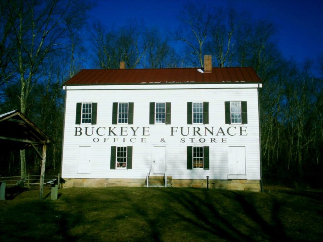
Buckeye Furnace, OH – (1851 – 1894 abandoned blast furnace town)
Classification: ghost town
Location: Milton Township, Jackson County – On Buckeye Park Rd near the intersection of Buckeye Rd
It was a typical blast furnace community with a few hundred residents and was abandoned when production stopped. The town had a church, general store, wood frame houses for the residents, and post office from 1851 – 1865. The land was donated to the state in the 1930s and the furnace was rebuilt in 1972 by the Ohio Historical Society.
Buckeye Furnace is now a 270-acre state park with picnic areas and hiking trails. Several of the original furnace and town buildings have also been restored including charging shed, iron master’s house, a storage shed, and the company general store which is open Saturday and Sunday 12 – 4. Buckeye Furnace Cemetery is up the hill behind the company store where some of the residents were buried. There are just a few tombstones left, but the cemetery has a lot more burials in unmarked graves. A fall festival is also held at the furnace every year.
Jefferson Furnace, OH – (1853 – 1916 coal mining and iron furnace town abandoned when production stopped)
Classification: ghost town
Location: Jefferson Township, Jackson County – On SR 279 close to Jackson Lake
The furnace is viewable from a picnic area on the west side of Jackson Lake. Jefferson Furnace was founded by a group of Welsh immigrants and businessmen. It had an important role in the Civil War by providing high quality iron that was used to make the U.S.S. Monitor ironclad battleship and guns for Harper’s Ferry. The area was abandoned when the furnace shut down and is now part of Jackson Lake State Park.
Keystone, OH (1848 – present mining, furnace, and farming town partially abandoned after the furnace stopped production)
Classification: small town
Location: Bloomfield Township, Jackson County – On Keystone Furnace Rd near the intersection of Orpheus – Keystone Rd
Like many of the surrounding townships and counties, Bloomfield was blessed with an abundance of iron and coal which drove the local economy to heights it had never seen before. Construction of the iron furnace began in 1846 and was completed in 1847. As with all of the 1800s furnaces in Ohio, it created hundred of jobs with the mining and railroad industry in an area that was previously dominated by farming and livestock.
Keystone Furnace started blasting iron ore in 1848. Most of the other iron furnaces in Ohio continued operation during the Civil War to provide steel for the Union troops, but Keystone shut down in 1861. Some of its owners were already enlisted in the U.S. Army, and many of its workers signed on to the 27th Ohio Volunteer Infantry which was involved in numerous battles and campaigns. They bravely fought at Corinth, Tennessee and also joined up with Grant’s forces that were heading for the New Orleans area. The soldiers eventually returned home victorious and highly decorated in 1863 – 1865 and resumed working at the furnace.
Mining and furnace work was dangerous to begin with, but Keystone had more perils than usual. Raccoon Creek, the world’s longest creek, was used to ship iron and coal to the furnace. Boats 60 – 85 feet long and averaging 55 tons were controlled by 4 men each. Many workers perished by drowning in the creek attempting to do tasks near the many mill dams in the area. Nicholas Bishop was killed in a lightning strike while hauling iron to the furnace with an ox wagon.
Keystone’s post office ran from 1849 – 1907, a large portion of that time being in the Keystone Furnace Company general store. A one room schoolhouse that was built in 1846 was replaced by a two story combination school and church in 1867. The town also had a grist mill and saw mill between the furnace and Raccoon Creek. A blacksmith shop, wagon shop, and the company store were across the road from the furnace. Burials took place at 3 cemeteries, Keystone Furnace Cemetery off of Bain Perkins Rd, Perkins Cemetery further up Bain Perkins where it’s called Dupre Rd, and Union Cemetery off of SR 327. The parents and paternal grandfather of Jacob Gee, the subject of our sketch of Gee Town, were also buried in Keystone Cemetery. Furnace operations ended in 1885. It was added to the National Register of Historic Places in 1982.
These days, Keystone Furnace is on private property but is visitable with permission from the land owner. All that the owner asks is that you ask first, pick up any trash you come across, and leave the snakes alone (lookout for copperheads!). If you’re headed east on Keystone Furnace Rd, it’s the first house past the old iron bridge (a left turn north), and if headed west it’s a right turn before the iron bridge. We suspect on top of the furnace itself, there also might be some remains of the engine house and other outbuildings.
Jackson County, Ohio Ghost Towns Research Resources
1875 – Jackson County atlas
1910 – Jackson County map
1900 – A History of Jackson County, Ohio – Vol. 1
-
https://books.google.com/books?id=3CsVAAAAYAAJ&printsec=frontcover&source=gbs_ge_summary_r&cad=0#v=onepage&q&f=false
1916 – A Standard History of the Hanging Rock Iron Region of Ohio – Vol. 1
1916 – A Standard History of the Hanging Rock Iron Region of Ohio – Vol. 2
