

Amsterdam (New Amsterdam) – Paint Township, Highland County and Paint and Paxton Township, Ross County
Location: 39.232373, -83.289902
on Falls Rd along Paint Creek between Rapid Forge Rd and Cove Run Rd
Remnants: none known
Description: Revolutionary War veteran General Nathaniel Massie (1763 – 1813) and Dutch immigrant brothers Jacob and Enoch Smith built a dam together at the falls of Paint Creek in the late 1790s. Nathaniel built a grist mill, distillery, and a small furnace on the north side of the creek and a saw mill on the south side of the creek, while the Smith brothers built a large saw mill on the north side of the creek. The mills went into operation in 1798 and they platted Amsterdam in 1800. Nathaniel didn’t want to compete with the Smith brothers in the lumber industry, so he abandoned his saw mill after building his house and supplying lumber for a few neighbors. Fine farmland along the creek attracted new residents and the town quickly grew with many cabins and a few shops. However, the location was deemed unhealthy and supposedly malaria nightmare. Although those sentiments were mostly boasted by people with interests in other potential town sites. Nathaniel looked for a more favorable site anyway, founded Bainbridge in 1805, and Amsterdam was subsequently abandoned. A historical marker for Nathaniel Massie’s home in Paxton Township is on the south side of US 50 just west of Bainbridge.
Clear Creek (Clear Creek Settlement) (Evans Settlement) – Liberty Township
Location: 39.236829, -83.608765
on US 62 at the intersection Diamon Dr along Clear Creek
Remnants: none known
Description: The Evans family arrived in the area in 1799 and settled along Clear Creek with Revolutionary War veteran Hugh Evans (1730 – 1808) and Lavinia (Simpson) Evans (1733 – 1811) from Washington County, Maryland being the patriarch and matriarch. Hugh’s first wife Sarah (Hardin) Evans passed away sometime after the birth of their only child. He married Lavinia in 1763 and had 6 more children. The family lived in Pennsylvania before moving to Bourbon County, Kentucky where more pioneers would come from to join in the opportunity of developing a safe and prosperous environment for their families to succeed at Clear Creek. The residents initially raised crops including corn and watermelons, helping feed their families and local Native Americans which mostly consisted of Shawnees and Wyandots. German immigrant John Belzer operated a blacksmith shop and Joseph Knox from Virginia was the first wheelwright in the county, producing much needed spinning wheels for making thread for clothes. The town also had a Methodist church and a school 1/2 of a mile north of the GPS coordinates in the southeast corner of the intersection of US 68 and Selph Rd. Clear Creek fell into obscurity in the late 1800s and has since been absorbed by Hillsboro’s growth. Hugh and Lavinia were laid to rest with relatives in a cemetery, which was lost to time and nature long ago, on their homestead farm that was passed down through the family for several generations.
Gall – Brushcreek Township
Post Office: 1895 – 1905
Location: 39.092097, -83.461115
on Sinking Spring Rd at the intersection of N Elmwood Rd along Middle Fork Ohio Brush Creek
Remnants: Countryman Cemetery on the north side of Sinking Spring Rd just northwest of the GPS coordinates
Description: The proprietor James N. Gall (1864 – 1942) was a teacher, farmer, and ran a general store and post office on the farm where he was born in the northeast lot of the intersection. A school was north of the intersection on a former stretch of Armstrong Ln which crossed the creek heading south to Gall back in the day. James M. Patton (1849 – 1913), a brother-in-law of James N. Gall, took on the postmaster position until the office was discontinued. James Patton was buried with relatives in Pleasant Hill Cemetery about 5 miles west of the GPS coordinates in Sinking Spring. By 1905, the Rural Free Delivery (RFD) system for mail was being implemented across the state and getting faster with the use of automobiles. James N. Gall was buried with relatives in Marshall Cemetery about 5 miles northwest of the GPS coordinates at the intersection of SR 124 and Herbert Rd. He was from the 5th generation of his family to reside on the homestead farm, dating back to German immigrant and Revolutionary War veteran George Gall (1766 – 1851) and Susannah (Nicholas) Gall (1764 – 1799) from Augusta County, Virginia. They were laid to rest in Old Dutch Cemetery 3 miles northeast of the GPS coordinates on the east side of Stanley Rd. The Countryman family, whose cemetery is listed as a remnant, also owned a few farms in the area.
Honolulu – Salem Township
Post Office: 1893 – 1898
Location: 39.167919, -83.836937
on SR 134 at the intersection of Murtland Rd along Little North Fork White Oak Creek
Remnants: former one-room schoolhouse on the east side of SR 124 just north of the GPS coordinates
Description: This small farming and postal town was founded by Civil War veteran Elijah Lafferty (1841 – 1914) and Mary Jane (Thomas) Lafferty (1844 – 1928). They had a few children and Elijah was the postmaster. The former one-room schoolhouse is currently a private residence. Elijah and Mary Jane were laid to rest with relatives 3 miles southeast of the GPS coordinates in Barker (Pricetown / Salem Township) Cemetery at the intersection of SR 131 and Certier Rd.
Littleton – Salem Township
Post Office: 1883 – 1903
Location: 39.167291, -83.788882
on Dawson Rd (Co Hwy 58) at the intersection of N Ford Rd along North Fork White Oak Creek
Remnants: none known
Description: Littleton was another small farming and postal town with a school (Salem Township No. 5). It had a lot of postmasters over the years, including Henry Clay Dawson, P. J. Shenkle, F. J. Stanforth, John H. Barr, J. W. Thornburg, and Calvin Stroup. Henry Clay Dawson (1834 – 1911) from Fayette County, Pennsylvania served two terms as a representative in the state legislature. He married Mary (McCloskey) Dawson (1846 – 1925), also from Pennsylvania, and had a few children. They were buried with relatives in Hillsboro Cemetery on the north side of SR 138 (Greenfield Pike) in Hillsboro. Dawson Rd was named after their family.
Sharpsville – Union Township
Post Office: 1852 – 1855
Location: 39.255626, -83.75054
on Sharpsville Rd along Turtle Creek between Quarry Rd and Bald Knob Rd
Remnants: none known
Description: The town was founded by James Sharp (1799 – 1872) and Margaret (Cloud) Sharp (1801 – 1869) who were both born in Pennsylvania. They got married in Highland County in 1826, had a few children, and accumulated a 400-acre farm with funds raised from a saw mill and grist mill constructed by James next to Turtle Creek. John B. Hayes was the first postmaster and was succeeded by William Hill. The town also had a Methodist Church and a school. It lasted much longer than the post office and was listed on the Union Township maps in all of the county’s historic atlases. Daniel Sharp (1837 – 1907) owned a quarry on the old family farm and was buried with relatives in Masonic Cemetery 2 1/2 miles west of the GPS coordinates on SR 134 in Lynchburg. The quarry operations eventually grew to proportions which Daniel likely never could have imagined and can easily be seen on satellite maps. James and Margaret were laid to rest with relatives in Mount Olive Cemetery 5 miles northeast of the GPS coordinates on the west side of Mad River Rd (Co Rd 7).
Sicily – Clay Township
Post Office: 1848 – 1895
Location: 39.028558, -83.863410
on Sicily Rd (Co Hwy 43) at the intersection of Ellis Rd
Remnants: Huggins (Huggens / Peddicord) Cemetery on private property in the woods on the east side of Sicily Rd about 1/2 of a mile northwest of the GPS coordinates
Description: Sicily was founded in the early 1830s by the Huggins family and was platted in 1848 by John N. Huggins (1810 – 1860) from Mecklenburg County, North Carolina and Isabella (Hindman) Huggins (1813 – 1899). John’s parents, Robert Huggins (1768 – 1839 and Sarah (Irwin) Huggins (1781 – 1875) also settled in the area along with some of his siblings. They left North Carolina in 1813 because of their hatred of slavery and spent 13 years near Ripley in Brown County before moving to Highland County in 1826. The family assisted slaves who were traveling further north on the Underground Railroad in both counties. John and Isabella got married in 1833, had a few children, and owned a large farm. Some of Sicily’s lots sold to other families. The town had a school (Clay Township No. 8), a steam-powered saw mill, grist mill, carding mill, doctor, and a church congregation. The known postmasters were Harvey S. Scarborough, John N. Huggins, Milton Cox, Lawson Huggins, William Matthews, John Shockey (also the doctor), M. W. Channel, and Rufus Shockey. Sicily lost all of its businesses as the owners moved or passed away. The town limped its way into the 1916 county atlas and faded out of existence prior to the mid-1900s. Everyone in the Huggins family mentioned in this listing was buried with relatives and other residents in Huggins Cemetery. The Shockey surname was also spelled as Shockley in certain branches and on some historical records.
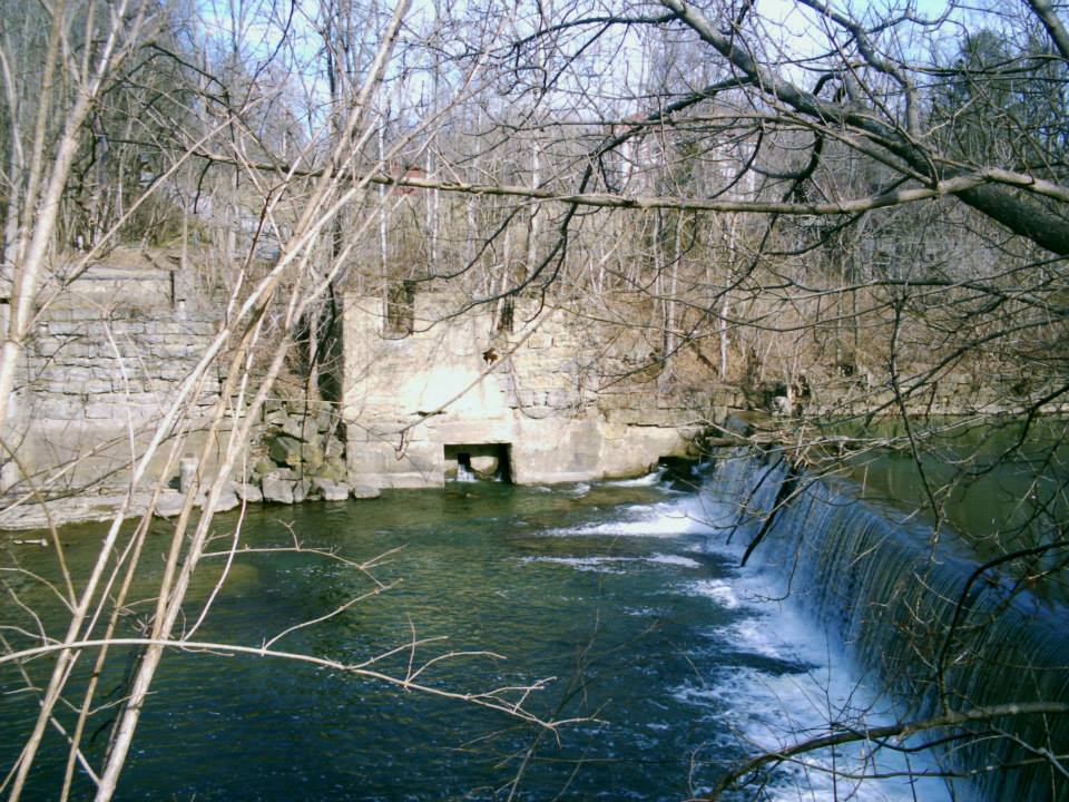
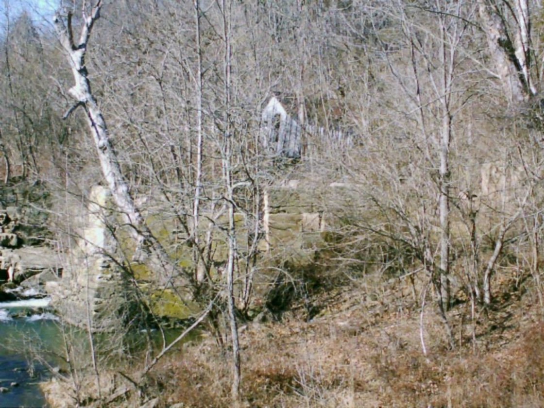
Barretts Mills, OH – (1806 – 1980 mill town, mill destroyed by an arson fire in 1980)
Classification: small town
Location: Paint Township, Highland County – On Barretts Mill Rd near the intersection of Cave Rd
In 1805 Jesse Baldwin (1759 – 1820) and Hannah (Thornbrough) Baldwin (1760 – 1820) were the first settlers of what would eventually become Barretts Mills. Jesse built a saw mill and grist mill that also had carding and fulling capabilities. It was completed in 1806. Dr. John Boyd, one of the first physicians in Highland County, purchased the land and improved the saw mill and grist mill in 1823. He also constructed a new wool mill next to the bank of Factory Branch Creek.
Barretts Mills also had a blacksmith, George M. Belleson, who died in 1856 and was buried in the Boyd Cemetery in the woods near Cave Rd. George’s son James C. Belleson was given the blacksmith work shortly before his fathers death. Dr. John Boyd later gave the mills to his son John Milton Boyd (1817 – 1913) who sold them to David Barrett (1829 – ?) in 1858. David married Sally A. (Weyer) Barrett (d. 1901) in 1855 and achieved the rank of captain in the Civil War.
A covered bridge was built in 1862 that spanned Factory Branch Creek from Barretts Mill Rd to Cave Rd. The town had a post office from 1885 – 1907. One of the buildings that Dr. Boyd built turned into a hospital for victims of the 1918 flu epidemic. Many people likely perished in that building and we believe there are a lot more people buried in Boyd Cemetery than the 5 interments cited on findagrave.com. The house on Cave Rd across from Barretts Mill is reportedly haunted too.
In the 1960s Jack Hope, a local property owner, purchased Barretts Mill and turned it into a tourist attraction. He also bought the nearby McCoppin Mill on the southeast side of Rocky Fork Lake in 1980. Unfortunately Barretts Mill and the covered bridge burned down in an arson fire in 1980, but it’s an interesting place to visit with the mill foundation and bridge abutments still intact.
Thanks to Rhonda L. Henson for providing the lead on Barretts Mills!

Fallsville, OH – (1848 – 1893 farming and mill town slowly abandoned over time)
Classification: ghost town
Location: Penn Township, Highland County – On hiking trails off of Careytown Rd
Fallsville was founded by John W. Timberlake who built a stone house and a grist mill next to the impressive waterfall on Clear Creek. In 1825 Simon Clouser (1796 – 1881) and his wife Elizabeth (Duckwall) Clouser (1797 – 1875) purchased the land from John and moved into the house in 1826. Simon was a farmer and operated the grist mill for people who came from miles around because it was the only large corn grinder in the area.
The Auburn Methodist congregation formed along with its first church structure, a log cabin built in 1830. On April, 20 1848 John Timberlake officially platted the town and named it after the waterfall next to the mill which is now part of The Fallsville Wildlife Area. More residents moved into town and Fallsville grew to have 8 houses on its 3 streets in the plat and a few more on the outskirts. The residents thought Fallsville would attract a railroad and become a large town, but that never happened.
Despite Fallsville being well on its way to fading out of existence, a new Auburn Methodist Church was built in 1891 to accommodate its members from the surrounding area. It replaced a smaller wood frame structure built after the log cabin church days and still stands today as the last structure built in town. Fallsville’s last remaining resident was Andrew Payton who died in 1893. Simon and Elizabeth Clouser were buried with their children at Auburn Church Cemetery on Careytown Rd. The Clouser girls were always described as being very strange, almost witch-like, and some of the locals steered clear of them so to speak.
The waterfall and remnants of the town are off of Fallsville Ln (Township Hwy 432), the gravel road south of Auburn Church. It’s blocked off from traffic, but a small parking lot at the front of the road is used for access. To get to the waterfall, keep going straight onto the trail past where the gravel ends on Fallsville Ln. The waterfall is on the right side of the path. Building foundations, sections of property line fences, and an old horse tank (the only one we’ve ever seen in a ghost town) can be found when hiking south from where the gravel ends on Fallsville Ln, a left turn heading into the woods.
Hunting goes on back there, especially during turkey season, so we recommend wearing bright colors while visiting. The hunters we met were all very nice and even gave us some info on where to look for remnants. Nature photography is another common activity in the wildlife area. Fallsville also has a ghost story about a Native American girl who knocks on doors around town on Christmas Eve. She’s said to be trying to tell local residents the location of a gold treasure buried nearby.
McCoppin Mill, OH – (1830 – 1979 mill town abandoned over time)
Classification: small town
Location: Marshall Township, Highland County – On McCoppin Mill Rd near the southeast side of Rocky Fork Lake
David Reece first settled there in 1829 and built a saw mill and grist mill on Rocky Fork Creek. The mill production started in 1831 and changed ownership several times over the next 150 years. In 1848 it was bought by Henry Stacy Foraker who had married David Reece’s daughter. Their son Joseph Benson Foraker (1846 – 1917) ended up being a U.S. senator and a two-time governor of Ohio. In 1895 the mill owners were C.M. Overman and Thomas Costello. Costello bought out Overman’s share and changed the mills name to Lodores, due to the fact that the poem “Cataract of Lodores” was posted at the mill.
Lodores had a post office from 1898 – 1903. Thomas Costello died in 1906 in a machine accident at the mill. His body was found in Rocky Fork Creek. John Allen McCoppin (1847 – 1931) bought the mill later that same year and remodeled it. The mill opened back up in 1909 and changed ownership a few more times. Lynn A. Sydenstricker and his son John were the last operators. They stopped production in 1979.
The mill was bought by Jack Hope in 1980, the same year he bought Barretts Mill. McCoppin Mill currently sits of private property but can be seen from the bridge on McCoppin Mill Rd. The town’s abandoned one-room schoolhouse is next to McCoppin Mill Rd south of the mill.
Thanks to Rhonda L. Henson for providing the lead on McCoppin Mill!

Highland County, Ohio Ghost Towns Research Resources
1871 – Highland County atlas
1887 – Highland County atlas
1916 – Highland County atlas
1878 – The History of the County of Highland
1890 – A History of the Early Settlement of Highland County, Ohio
1902 – The County of Highland

Featuring 3 towns with 7 pictures from Highland County, along with historical research about the locations, Abandoned Ohio was released by Fonthill Media and Arcadia Publishing on October 1st, 2018. It’s packed with history, ideas for road trips, and also makes an awesome birthday or holiday gift!
Ordering Links
Arcadia Publishing – https://www.arcadiapublishing.com/Products/9781634990615
Amazon – https://www.amazon.com/Glenn-Morris/e/B07G8N3HP2/ref=ntt_dp_epwbk_0
Barnes & Noble – https://www.barnesandnoble.com/w/abandoned-ohio-glenn-morris/1129366623
Walmart – https://www.walmart.com/ip/Abandoned-Ohio-Ghost-Town-Cemeteries-Schools-and-More/315294168
