Beaver Creek – Richfield Township
Post Office: 1840 – 1847
Location: unknown
Description: It was in the eastern half of the township and didn’t have a village. John Sowers was the proprietor and postmaster.
Cloverleaf – Liberty Township
Location: 41.471600, -84.076466
on Co Rd V at the intersection of Township Rd 11
Remnants: former one-room schoolhouse a mile east of the GPS coordinates in the southeast corner of the intersection of Co Rd V and Co Rd 10, old houses and farm buildings in the area
Description: This small farming town was listed on the page 35 of the 1910 atlas published by the State Highway Department. The former one-room schoolhouse appears to be in good shape for its age with fitted cut boards covering the window openings, a rib steel covered roof, and a tall lightning rod rising well above the roof line over the door. There isn’t any missing bricks and the yard is also well-kept.
Damascus – Liberty Township (formerly in Damascus Township, Wood County)
Post Office: 1819 – 1868
Location: 41.411639, -84.009347
on SR 109 at the 4-way intersection of Old US 24 and SR 424 (East Riverview Ave) between the Maumee River and North Turkeyfoot Creek
Remnants: Damascus Cemetery on the east side of Co Rd 8 about a mile northwest of the GPS coordinates, historical marker in the southwest corner of the intersection
Description: Damascus was platted at the site of a former Native American village from the mid-1700s called Prairie Du Masque (Prairie Des Mascoutins). It was temporarily the original county seat before that honor was moved to the booming town of Napoleon in 1835 just 3 years after it was platted. Charles Gunn was the first known postmaster of Damascus. He was succeeded by David Bucklin, Norman Mead, E. S. Dodd, John Burlin, J. R. Thompson, Benjamin A. High, D. C. Smith, and A. J. Wheeler. Damascus still had a saw mill on the south side of the main intersection and a school on the west side of Co Rd 8 just south of the cemetery listed in the 1875 county atlas. Damascus was listed in the 1910 State Highway atlas and faded into oblivion before the mid-1900s.
Durand – Liberty Township
Post Office: 1851 – 1866
Location: unknown
Description: George Stebbins (born c. 1822) from Connecticut was the first known postmaster. David F. Welsted (1816 – 1886) from New Jersey was the last postmaster. He served as county commissioner in the early 1850s and was buried with relatives in Glenwood Cemetery on Glenwood Ave in Napoleon.
Girtys Point – Harrison Township
Location: 41.326751, -84.154081
on County Rd Z at the intersection of County Rd 15
Remnants: Cole Cemetery on south side of the road just east of the intersection
Description: The town was named after Simon Girty (1741 – 1818) who was captured by Seneca natives with his family in Pennsylvania and adopted by the tribe, living with them until 1764. He joined the British and Native American resistance against American settlers and troops. After getting involved in numerous notorious incidents with Ohio’s pioneers, Simon hid out on Girty’s Island on the Maumee River across from Cole Cemetery where he and his brother George had trading posts in the 1780s and 1790s. The island later turned into a Victorian Era amusement park.
Goosetown (Goose Town) – Napoleon Township
Location: unknown
Description: Goosetown was along the Maumee River and was initially chosen by the proprietors of Napoleon to be the site of that town. However, the land was on low ground and frequently flooded badly. The idea of platting there was scrapped in favor of Napoleon’s present location further upstream where the Maumee River wasn’t nearly as much of a threat. The name Goosetown was later given to the beautiful but too often submerged area which lost the opportunity to have Napoleon’s plat.
Madeira – Marion Township, Henry County and Liberty Township, Putnam County
Location: 41.166769, -84.054575
on Henry County Rd A at the intersection of Township Rd 10 on the Henry and Putnam County border
Remnants: none known
Description: Madeira’s only claim to fame was being mentioned as a small place in the 1847 first edition of Henry Howe’s Historical Collections Of Ohio.
Odessa – Damascus Township
Post Office: 1856 – 1867
Location: 41.412939, -83.973952
on SR 110 along the Maumee River and South Turkeyfoot Creek between Co Rd 6B and Co Rd 5A
Remnants: Creager (Kruger) Cemetery about 2 miles southwest of the GPS coordinates on the south side of SR 110 between SR 109 and Co Rd 7, Olive Branch Cemetery 2 1/2 miles southeast of the GPS coordinates on the west side of County Rd 5A between County Rd P and Township Rd O4
Description: Odessa was founded by Scottish immigrant Thomas Reid (1813 – 1878) and Elmira (Crockett) Reid (1824 – 1897) from Knox County, Maine. Thomas had 3 children with his first wife Marion (Bone) Reid. She passed away in 1841. Thomas moved to the U.S. with his children, mother, and 2 sisters in 1843. He married Elmira (or Almira) in 1854 and had 9 more children. They owned a grist mill on the east side of South Turkeyfoot Creek near the GPS coordinates. There was also a saw mill just south of the grist mill on the east side of Co Rd 5A and the town had a general store. John S. McKee (1805 – 1880) was the only known postmaster. The Maumee River and the Miami & Erie Canal were used to transport goods in and out of the area. Odessa was hit hard by a cholera epidemic in the mid-1800s, but it was still the largest village in the township before McClure was platted in 1880 and boomed with a train station on the Toledo, Delphos, & Burlington Railroad (later the Toledo, St. Louis, & Western Railroad). Thomas was buried with relatives in Creager Cemetery just across the border in Harrison Township and Elmira was laid to rest with relatives in Olive Branch Cemetery. John McKee was also buried in Olive Branch Cemetery.
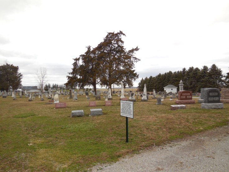
Ridgeland – Marion Township
Post Office: 1850 – 1896
Location: 41.193889, -84.067772
on Co Rd Y at the intersection of Co Rd 10A
Remnants: Marion Township Cemetery on the north side of Co Rd Y just east of the intersection, old houses and farm buildings in the area
Description: Ridgeland was founded in 1841 by Samuel Hashbarger (1815 – 1859) and Anna (Rader) Hashbarger (1815 – 1889). They had a few children and Anna remarried after Samuel passed away. In 1863 George W. Edwards (1834 – 1919) and John Rayle (1831 – 1915) platted the town with 72 lots and 2 outlots. They attempted to change its name to Edwardsville. The U.S. Postal Service denied the request though as there was already an Edwardsville with a post office in Warren County. Ridgeland’s known postmasters over the years were Samuel Warwick, John Hamler, Casper Sirolff, Enoch J. Stevenson, William P. Young, and Peter Punches. Civil War veteran William P. Young (1825 – 1899) owned a 79-acre farm across the road from Marion Township Cemetery and operated a saw mill, tile factory, and stave factory which produced wood strips for barrel sides. One of the closest local one-room schoolhouses still stands 1 1/2 miles southeast of the GPS coordinates on the west side of Township Rd 10. It’s presently in dilapidated condition but is a neat site to see and is very photogenic. The Hashbargers, George Edwards, John Rayle, William Young, and some of the other postmasters were buried with relatives in the cemetery.
Turkey Foot (Turkeyfoot) – Freedom Township
Post Office: 1840 – 1849
Location: unknown
Description: Samuel Knapp was the proprietor and postmaster.
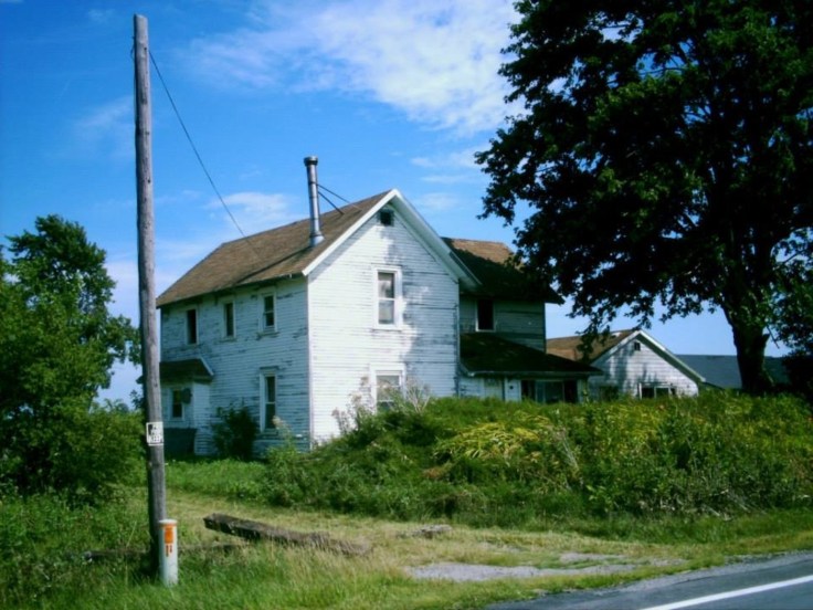
Westhope, OH (mid-1800s – present farming town)
Classification: small town
Location: Richfield Township, Henry County – On SR 65 at the intersection of Co Rd J
Westhope was originially called Richfield Center starting around the early 1890s. It was never platted and didn’t have any major businesses besides farming. It really only found its way onto maps due to having a general store, church, and a post office from 1869 – 1919. The church is still in operation and is the only public building in town. An abandoned farmhouse next to State Route 65 between State Route 281 and County Road H1 has a very historic look and will hopefully get restored someday.