
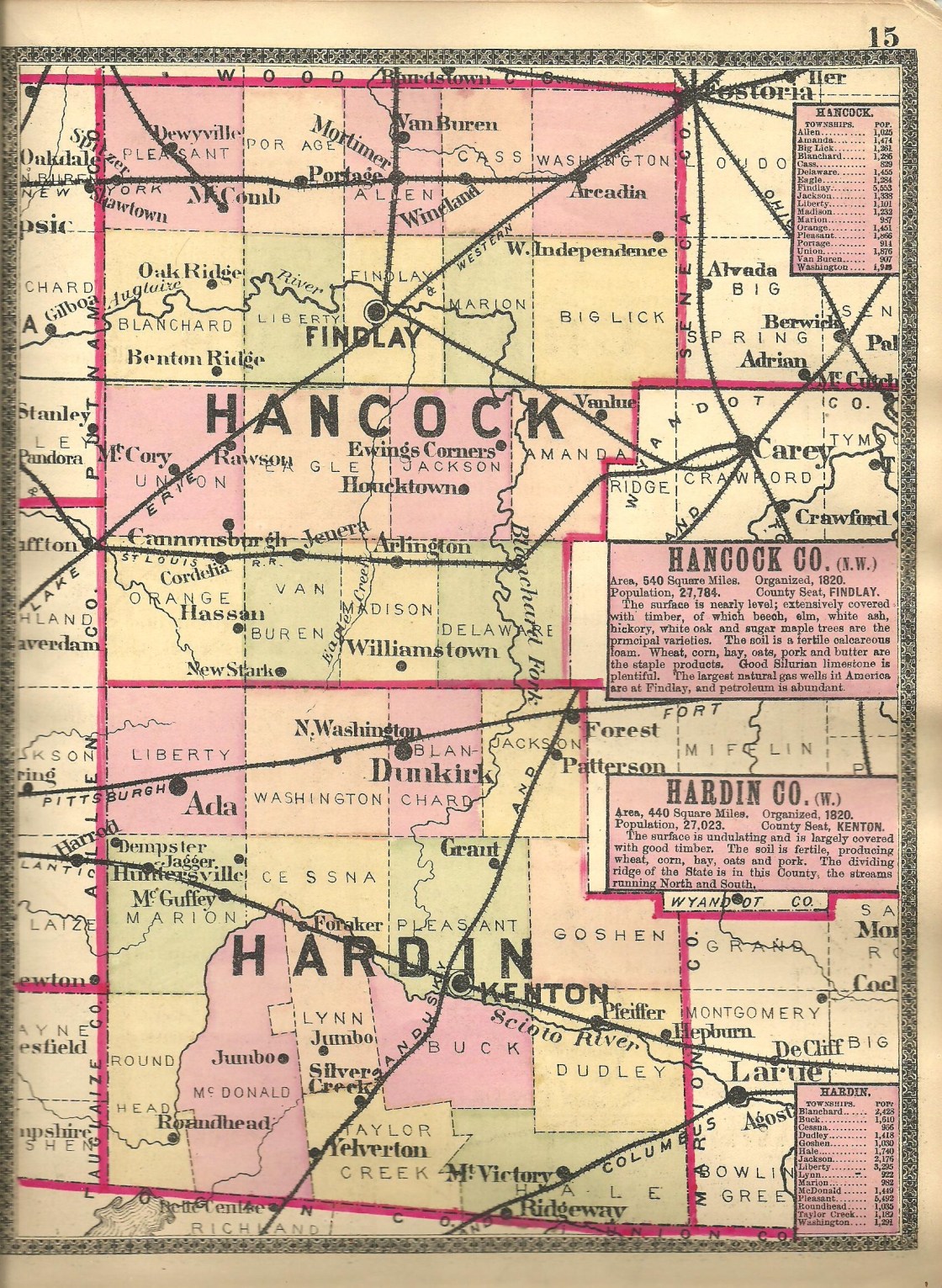
Blocktown – Washington Township
Post Office: dates not listed
Location: 40.746944, -83.690603
on Locker Rd (Co Rd 60) at the intersection of Co Rd 115
Remnants: St. John’s Lutheran Church at the GPS coordinates, old and abandoned houses and farm buildings in the area
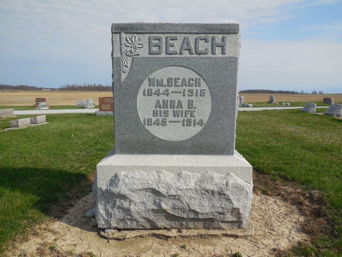
Description: The town was founded in 1877 by German immigrants Charles Block (1841 – 1899) and Elizabeth Block (1843 – 1911). They owned a general store and a blacksmith shop in the northwest corner of the intersection, and a saw mill and cider mill in the northeast lot of the intersection. Charles was also the town’s postmaster and the family’s enterprises employed many local residents. The 58-acre lot with the mills was sold to German immigrant William Beach (1844 – 1916) and Anna (Barcet) Beach prior to publication of the 1879 county atlas. There were 2 local one-room schoolhouses, Washington Township No. 4 on the east side of Township Rd 105 just north of Locker Rd and Washington Township No. 3 in the northeast corner of the intersection of Locker Rd and Kaylor Rd (Township Rd 125). St. John’s Lutheran Church was organized in the early 1850s. Their first church was a wood frame structure in the southeast corner of Locker Rd and Township Rd 105, built in 1873 at a cost of $1,600. It was later replaced by the present brick structure when the congregation needed a larger building. There isn’t a ton of abandoned farmhouses in the area, but those that remain aren’t worth fixing up, or spending any money to get rid of them for that matter. They will soon be lost to time and nature anyway, and it’s neat they are tied to the ghost town. The other old houses in the area which are still in use are well-maintained. William and Anna Beach were laid to rest with relatives and other resident of Blocktown in Dola Cemetery 3 miles northeast of the GPS coordinates on the north side of SR 81. The Block family moved out of the state and Blocktown faded into obscurity in the early 1900s. Charles and Elizabeth had 5 children and were buried with relatives in Oak Ridge Cemetery on College Ave in Kennett in Dunklin County, Missouri.
Geneva – Blanchard Township
Location: 40.782956, -83.641832
on US 68 at the intersection of SR 81 (Geneva St)
Remnants: none known
Description: Geneva never made it past the proposal stage. When the Pennsylvania Railroad was being built through the township, the future village site was moved north to the tracks instead of leaving it at the area’s main crossroads which were basically heading for economic obsoletion. It was a good move and the timing of it all couldn’t have been better. As seen in other places around the state, Geneva likely would have failed. Dunkirk was platted at the tracks in 1852 by Hugh Miller (1807 – 1890) from Virginia and named by him after Dunkirk, New York. Hugh was buried with relatives in Dunkirk Cemetery 1/2 of a mile south of the GPS coordinates on the west side of US 68.
Grange – Lynn Township
Location: 40.629353, -83.682678
on Lynn Valley Pike (Co Rd 115) at the intersection of Co Rd 150
Remnants: former one-room schoolhouse in the southwest corner of the intersection, old houses and farm buildings in the area
Description: It had a grange hall on the north side of the GPS coordinates, Lynn Valley Grange No. 581, and the one-room schoolhouse (Lynn Township No. 1). The grange hall was built on land owned by Civil War veteran Henry G. Wolgamot (1847 – 1922) from Holmes County and Mary (Siegel) Wolgamot (1856 – 1891). Henry had at least 7 children with Mary and remarried after she passed away. They were buried with relatives in Grove Cemetery about 7 miles east of town on the north side of SR 309 in Kenton. Some other residents were buried in Norman Cemetery 3 miles south of the GPS coordinates on the west side of Co Rd 115.
Marshs (Marshes) – Dudley Township
Location: 40.558945, -83.441590
on Co Rd 245 at the railroad crossing between Co Rd 202 and Township Rd 230
Remnants: none known
Description: It was on the Cleveland, Cincinnati, Chicago, & St. Louis Railroad (Big Four Railroad) and was listed on the Ohio map in the 1901 George Cram atlas. There was a school (Dudley Township No. 10) about a mile northeast of the GPS coordinates on the north side of Co Rd 202.
McDonald – McDonald Township
Post Office: 1852 – 1873
Location: unknown
Description: The town was named after the McDonald family in the county descended from William McDonald who the township was named after. Residents were buried in McDonald Fairview (Harvey) Cemetery on SR 67 at the intersection of Dodds Rd (Township Rd 65). The postmasters were J. N. Abston, James Harvey, and Enoch Harvey.
McGoldricks Town – Cessna Township
Location: unknown
Description: Its proprietors Thomas McGoldrick (1793 – 1850) and Jane (Leedom) McGoldrick (1803 – 1872) moved to Hardin County from Pennsylvania in 1832 and had 13 children. Thomas platted the town in section 25 of Cessna Township in 1833. It never grew any and they moved out of the state after a few years. Thomas and Jane were buried with most of their immediate family in Glenwood (IOOF) Cemetery on State Hwy 202 in Schuyler County, Missouri.
Peru – Cessna and Pleasant Township
Location: 40.717474, -83.653223
on Co Rd 135 at the intersection of Hensel Rd (Township Rd 80)
Remnants: Cessna Cemetery on the north side of Hensel Rd 1/3 of a mile west of the GPS coordinates
Description: Peru was platted with 90 lots and a public square in 1836 by Charles Cessna (1784 – 1864) who was born in Pennsylvania and arrived in the township later named after him with some family members around 1830. The town had a store and a few houses, but it couldn’t compete with Huntersville or Kenton at the time. A couple of lots were purchased by the governor of Rhode Island. He didn’t moved to Ohio though or make any improvements on the land. Another 2 lots were purchased by a man from New York who checked out the land, left because of the harsh wilderness it was back then, and never returned. Charles was buried with relatives in Cessna Cemetery.
Saint Michaels – Goshen Township
Location: 40.643108, -83.472328
on SR 309 at the intersection of Co Rd 265
Remnants: none known
Description: It was platted in 1836 with 125 lots.
West Union – Blanchard and Washington Township, Hardin County and Madison Township, Hancock County
Location: 40.819480, -83.651423
Remnants: none known
Description: The town was platted with 48 lots in 1834 – 1835 by Andrew Sheller. None of the lots were sold or improved.
Huntersville, OH – (1836 – present saw mill and farming town with less residents than in the past)
Classification: semi-ghost town
Location: Marion and Cessna Township, Hardin County – On SR 309 near the intersection of County Rd 75
Huntersville was laid out in 1836 by Thomas Hitchcock (1810 – 1897) and was named after Jabez Hunter who was the first settler in the township. It had 2 stores, a blacksmith shop, church, saw mill, and a doctor. Up until 1882, Huntersville was the only village in Marion Township. It missed out on the railroad boom of the late 1800s though, which was the main reason for its decline in population as residents moved to more bustling towns. Huntersville lost its post office which ran from 1839 – 1875.
These days, the town just has a Baptist church, small park, and a few houses. Thomas Hitchcock moved to California in the mid-1800s with his wife Naomi (Cory) Hitchcock and their children, but his father Isaac Hitchcock (1790 – 1877) is buried in Huntersville Cemetery with many other early residents. From SR 309, turn north onto County Rd 75 and take the first right onto Township Rd 74.
Hardin County, Ohio Ghost Towns Research Resources
1879 – Hardin County atlas
1912 – Hardin County map
1883 – The History of Hardin County, Ohio
1895 – Portrait and Biographical Record of Marion and Hardin Counties, Ohio
1910 – A Twentieth Century History of Hardin County, Ohio – Vol. 1
1910 – A Twentieth Century History of Hardin County, Ohio – Vol. 2
