

Featuring 3 towns with 10 pictures from Hamilton County, Restored Ohio was released on April 29, 2019. It’s the sequel of Abandoned Ohio (2018) and shows a different side of what physically remains of Ohio’s past. Many of the locations operate as businesses such as restaurants, hotels (former stagecoach stops), museums, and working mills.
Ordering Links
Arcadia Publishing – https://www.arcadiapublishing.com/Products/9781634991216
Amazon – https://www.amazon.com/Glenn-Morris/e/B07G8N3HP2/ref=ntt_dp_epwbk_0
Barnes & Noble – https://www.barnesandnoble.com/w/restored-ohio-glenn-morris/1129901378?ean=9781634991216
Walmart – https://www.walmart.com/ip/Restored-Ohio/185272799
Target – https://www.target.com/p/restored-ohio-by-glenn-morris-paperback/-/A-78016964

Brachman – Anderson Township
Location: 39.086295, -84.378547
on SR 125 at the intersection of Brachman Ave
Remnants: none known
Description: The town was founded by German immigrant and Cincinnati wine merchant Henry Brachmann (1805 – 1882). He served in the state senate from 1862 – 1864 and organized the Cincinnati, Georgetown, & Portsmouth Railroad which ran from 1877 – 1936. The track line started in Columbia (East End), passed through the southern end of Brachman Ave, and ended in Russellville in Brown County. It never reached the intended destination of Portsmouth due to financial struggles. Henry and his wife Rosalia Brachmann (1803 – 1871) from Indiana owned a 99-acre farm at the GPS coordinates and had a few children. They were buried with relatives in Spring Grove Cemetery on Spring Grove Ave in Cincinnati.
Broadwell – Anderson Township
Location: 39.137092, -84.317683
on Broadwell Rd at the railroad crossing between Round Bottom Rd and Mt Carmel Rd
Remnants: Martin Family (Broadwell) Cemetery on the north side of Broadwell Rd about 1/4 of a mile northwest of the GPS coordinates inside the gated grounds of the Bway Corporation, Cyrus Broadwell House in the woods in the southeast corner of the intersection of Broadwell Rd and Mt Carmel Rd
Description: The original proprietors were Revolutionary War veteran Jacob Broadwell (1766 – 1836) and Jane (Williams) Broadwell (1769 – 1842). They moved to Ohio around 1799, had at least 5 children, and purchased a 200-acre farm on the east side of the GPS coordinates. Other members of the family also owned another 200-acre farm across from it on the north side of Broadwell Rd. One of Jacob and Jane’s sons, Cyrus Broadwell (1801 – 1879) from Anderson Township and his wife Virginia Broadwell (1808 – 1891) from Virginia, inherited the estate. They moved to the area shortly after 1840 when Cyrus retired from a successful boat business he ran with his brother Jacob in Cincinnati. The 11 room Greek Revival house on the property was built sometime between 1820 and 1850 and features 23 columns 12 feet tall that were carved from a single pine tree. It was listed on the National Register of Historic Places in 1975 and was owned by the Broadwell family until 1907. The town had a school on the north side of Broadwell Rd next to Martin Family Cemetery. It also had a stop on the Cincinnati & Eastern Railroad (later the Norfolk & Western Railway) in the late 1800s to early 1900s. Although there are no markers for them, Jacob and Jane Broadwell are believed to be buried in Martin Family Cemetery. The oldest members of the Martin family believed to have been interred there are Joseph Martin Sr. (1764 – 1845) and Rebecca (Gerard) Martin from Pennsylvania, also currently without markers. Cyrus and Virginia Broadwell were laid to rest in Greenlawn Cemetery about 5 1/2 miles northeast of the GPS coordinates on US 50 in Milford, Clermont County. Permission is needed from the Bway Corporation to visit Martin Family Cemetery and the Broadwell House is privately owned without access to the public. The town faded into obscurity in the early 1900s as gravel and sand mining overtook the former farmland.
Bucktown (Buxton) – City of Cincinnati
Location: 39.1050598, -84.5049427
on Eggleston Ave at the I-71 underpass
Remnants: none known
Description: Many former small towns, including Bucktown, Carrsville, Fulton, Pendleton, Rolling Ridge, Texas, Vernonville, and several others were annexed into Cincinnati as it grew throughout the 1800 and early 1900s. The same process was encountered while we researched other counties such as Franklin with Columbus and Cuyahoga with Cleveland. Absorbing smaller towns was simply necessary to create the major cities that turned Ohio into the state as we know it today. An interesting article on the subject was published by Cincinnati Magazine in 2017.
Magazine Article – https://www.cincinnatimagazine.com/citywiseblog/bucktown-vanceville-cincinnatis-lost-19th-century-neighborhoods/
Cedar Grove – City of Cincinnati (formerly in Green Township)
Location: 39.119155, -84.580822
on Gilsey Ave at the intersection of Gellenbeck St
Remnants: none known
Description: Cedar Grove was the location of Mount St. Vincent Academy (St. Vincent de Paul), a boarding school for girls. A beautiful engraving of the grounds and buildings is next to page 300 of the 1881 county history book. The four-story main building was constructed in 1858. There was also a convent with an attached chapel. The chapel was built in 1875 and the convent was formerly a lavish mansion on a 33-acre farm called The Cedars. Back then, convents were usually self-sustained farms and Cedar Grove was no exception to that. It had a poultry yard, fruit orchard, pasture, bakery, and everything else it needed to feed the residents and generate some income.
Centretown (Tucker’s Station) – Village of Woodlawn (formerly in Springfield Township)
Location: 39.248873, -84.466329
on Grandview Ave between Wayne Ave and the railroad tracks
Remnants: none known
Description: It was on the Cincinnati & Hamilton Railroad and was first spotted on the 1856 county map on a 253-acre farm owned by Manning R. Tucker (1801 – 1881) and Rebecca (Pearles) Tucker (1800 – 1870). Prior to that, the area was known as Tucker’s Station. However, station in this context doesn’t refer to railroads. In the days long before trains were invented, stations were fortified settlements specifically designed for protection from Native Americans. Residents would scurry into the fort at the first sign of trouble. In many unfortunate cases around the state, as mentioned in some of the 1800s and early 1900s county history books, residents didn’t always make their way inside the fort in time. Those that did had to successfully defend it or likely meet an an unnatural early demise. The plan for Tucker’s Station was organized by Manning’s parents, Henry Tucker (1760 – 1844) and Mary (McDaniels) Tucker (1760 – 1848) from New Jersey, and a few other families at Columbia in 1792 who wished to settle in and around what would later become section 4 of Springfield Township. Centretown appears to be a “paper town” though, platted but never came to fruition, and didn’t make it into the 1869 county atlas. It was within the present-day boundary of Woodlawn which was platted in 1876. Manning and Rebecca were laid to rest with relatives in Greenwood Cemetery on Greenwood Ave in Hamilton, Butler County.
Cilley – Whitewater Township
Location: 39.183118, -84.777555
on Kilby Rd along the railroad tracks at the 4-way intersection of Cilly Rd and Suspension Bridge Rd
Remnants: none known
Description: It’s unclear exactly when Cilley was a town as it isn’t pinpointed as such on any of the historic maps we have access to. The proprietors were members of the Cilley family, dating back to War of 1812 veteran Colonel Benjamin Cilley (1789 – 1851) from Rockingham County, New Hampshire and Martha (McCormick) Cilley (1806 – 1873). The Whitewater Canal was constructed through the area in 1836 – 1847, followed by the Whitewater Valley Railroad (later the Big Four). Benjamin and Martha had at least 5 children and were buried with relatives in Berea Cemetery 2 miles southeast of the GPS coordinates where Brotherhood Ave meets Adams St in Hooven.
Columbia Park – Miami Township
Post Office: 1927 – 1957
Location: 39.120835, -84.804498
on the south side of Shawnee Park Lookout Rd on an abandoned stretch of road heading north off of Brower Rd
Remnants: former houses from the town moved to Brower Rd, foundations in the area where the town was, set of steps that led to a clubhouse
Columbia Park was a company town established in 1925 by Columbia Power Gas & Electric which owned the Miami Fort Power Plant. In the mid-1920s, access to the facility was much more difficult. Brower Rd hadn’t been constructed yet and a narrow dirt road led to the plant. As a result, Columbia Park was built for the workers. They paid low rent for nice accommodations, including the use of a large three-story clubhouse near the southern end of what was Columbia Rd, and had a short walk their jobs. The clubhouse had rooms available for rent, a bowling alley, lounge, laundry, and a billiard room. Columbia Park also had a school and a community hall. In the mid-1950s, the projected cost of maintaining and renovating the rented houses was considered by the power company to be too expensive. They sent letters to the workers who lived in Columbia Park in 1856, basically telling them they had to find somewhere else to live and they were given ample time to do so. A few of the workers purchased their houses and moved them to Brower Rd. The rest of them were dismantled by the power company. The power plant is still in operation on the south side of Brower Rd and is currently owned by Duke Energy.
Dunlap’s Station (Fort Colerain) – Colerain Township
Location: 39.293190, -84.657642
on the west side of E Miami River Rd along the Great Miami River
Remnants: Heritage Park at the GPS coordinates, Hedges (Dunlap Station) Cemetery just northeast of the GPS coordinates at the end of an access road, stone historical marker near the park entrance
Description: John Dunlap from Colerain, Ireland established this fortified town in 1790. It was the first settlement in Hamilton County’s interior away from the Ohio River. The village consisted of 106 acres and the fort itself was 1-acre of enclosed land with 10 cabins housing around 30 residents, a rudimentary grist mill (hand-powered corn cracker), and 3 blockhouses. Some of the surnames of the residents were Birkit, Crum, Gibson, Hahn, and Larrison. Dunlap’s Station was about 17 miles from Cincinnati, which also made it vulnerable. A detachment of 13 American soldiers, including their commander Lieutenant Kingsbury, was sent to defend the settlement in 1791 during the Northwest Indian War. A surveying party of 4 men was attacked in the area on January 8th of that year, two days before an attempted Native American siege took place on Dunlap Station from January 10th – 11th. The attacking group were members of the confederated tribes of Shawnees, Miami (Myaami) , Lenapes (Delawares), Wyandots (Hurons), and Niswi-mishkodewin (Potawatomis). Their siege was unsuccessful and they left before a rescue party of 100 men from Columbia and Cincinnati arrived. Only a handful of American lives were lost during the conflict, including those from the surveying party who perished. One of them was reportedly buried at the spot where his body was found and the others in Hedges (Dunlap Station) Cemetery, although no markers for them exist. The fort was abandoned shortly after the attempted siege, mainly because the settlers didn’t have proper land claim titles and also in fear of possible attacks in the future. The confirmed burials at the cemetery are residents who later resettled the area.
Elizabeth
Location: unknown
Description: It was platted by Daniel Reeder in 1847. Most of the Reeder family settled in Sycamore Township which was previously part of Columbia Township. It was stated in the 1881 county history book that its writers couldn’t locate where the town was.
Elliston (Crestvue) – City of Springdale (formerly in Springfield Township)
Post Office: 1889 – 1901
Location: 39.301386, -84.465570
on Princeton Pike between Crescentville Rd and I-275
Remnants: none known
Description: William F. Muchmore (1834 – 1874) platted Elliston in 1868 and named it after a Mr. Ellis who lived in the neighborhood. The town had a train station on the Cincinnati, Hamilton, & Dayton Railroad. Its plat just had 7 lots on the west side of the GPS coordinates lined Princeton Pike between Cresentville Rd and the railroad tracks. The town was renamed Crestvue after William passed away. He was buried with relatives in Laurel (Laurel IOOF) Cemetery on Roe St in Madisonville. The post office was also called Crestvue. Henry Duskey (1832 – 1896) was the first postmaster. He was succeeded by Edward C. Vettel (1868 – 1944). They were both laid to rest in Brookside (West Chester) Cemetery 4 1/2 miles northeast of the GPS coordinates in West Chester Township, Butler County.
Ervina (Irvina) – Delhi, Green, and Miami Township
Location: 39.124270, -84.689575
on Cleves Warsaw Pike at the intersection of Old Hillside Ave along Muddy Creek
Remnants: none known
Description: Ervina is quite a mystery. Its only cartographic appearance was on the 1856 county map. There are no mentions of the place in the county history books, or in any of our other research resources for that matter. The 1847 county map pinpointed a small cluster of houses around the intersection. There was also a school on the north side of Cleves Warsaw Pike just northwest of the GPS coordinates during the time period in question.
Fort Gass – Whitewater Township
Location: 39.2175560, -84.7857833
on the west side of Kilby Rd along the Whitewater River
Remnants: none known
Description: It’s unknown who built the fort and when it was in existence. However, the location was reportedly pinponted from early maps of the area and has been confirmed by the U.S. Geographical Survey. There are presently 34 known interments of the surname Gass in Hamilton County’s cemeteries listed on Find A Grave.
Foster Hill – Village of Lincoln Heights (formerly in Springfield Township)
Location: 39.245070, -84.464263
on Wayne Ave at the intersection of Chester Rd
Remnants: none known
Description: Foster Hill was just south of Centreville along the Cincinnati, Hamilton, & Dayton Railroad. It was established in the mid-1800s by Lieutenant Luke Foster (born c. 1769 – 1857) from New York who was a pioneer settler at Columbia. He was patriotically famous, at least in Hamilton County, for sending 100 bushels of corn to Fort Washington in what is now downtown Cincinnati during a struggling time of feeding its residents in 1789. The town had an academy and later a regular school on the south side of the GPS coordinates. A Baptist church was on the east side of Wayne Ave south of the school. Luke was tragically killed by a gravel train that was passing through his farm. His burial location is unknown.
Glenmore – Green Township
Location: 39.147666, -84.612948
on Glenmore Ave between Darwin Ave and Hildreth Ave
Remnants: none known
Description: It was on the Cincinnati & Westwood Railroad which was in existence from 1874 – 1924. Glenmore had a train station near the GPS coordinates and was last spotted on the Green Township map in the 1914 county atlas. The train tracks were removed prior to the 1950s.
Griffin’s Station – Springfield Township
Location: 39.204492, -84.474885
on SR 4 (Vine St) along Mill Creek between Hartwell and Carthage
Remnants: none known
Description: Griffin’s Station was founded by Revolutionary War veteran Lieutenant Daniel Griffin (died c. 1794) who purchased what would become section 7 of Springfield Township in July of 1792. According to most historians, the settlement was likely established in fall of 1793. Some of the other initial residents were Daniel’s brother Robert, Jacob and Daniel Vorhis (Vorhees), James McCashen, Daniel Seward, Robert Caldwell and 2 of his sons, Samuel and James. Cabins were constructed on both sides of Mill Creek. James Caldwell bought 348 acres of the southern portion of section 7 from Daniel Griffin. The Caldwell family subsequently built a grist mill, saw mill, and a distillery. They were destroyed in a flood in 1806. The exact location of Griffin’s Station (Caldwell) Cemetery, which was southwest of the GPS coordinates, has since been lost to time. It was stated in the 1881 county history book that the cemetery had been plowed over and the gravestones were all gone. The last marker left was Richard Dill’s who built the first brick house in Cincinnati.
Miamme
Location: unknown
Description: It was a Native American village in the mid-1700s near the mouth of the Little Miami River prior to the settlement of Columbia.
Montauk (Armstrong Mill) (Milford Station) – City of Milford (formerly in Columbia Township)
Post Office: 1860 – 1861
Location: 39.170467, -84.299590
on US 50 (Wooster Pike) at the intersection of Ferry St
Remnants: former Baptist Church southeast of the GPS coordinates on the east side of Longworth St, old houses and business buildings in the area
Description: Nathaniel Armstrong (1749 – 1840) and Hannah (Norris) Armstrong (1743 – 1827) got married in 1769 in Maryland, had 11 children, and moved to Ohio in 1800 after living in Virginia for a couple of decades. Nathaniel built a grist mill which produced well-known flour and corn meal. Originally called Armstrong Mill, the town was platted in 1840 as Monatuk, to match the brand name of the flour, in anticipation of the arrival of the Little Miami Railroad. By the late 1860s, Montauk had a train station, the Baptist Church, a school, saw mill, saloon, blacksmith, and a small seminary. Descendants of Nathaniel and Hannah kept the mill in operation. The heyday of the 1880s increased the number of saloons to 3. Its sawmill turned into a busy lumber yard and planing mill. There was also a coal and lime yard and the old blacksmith shop was replaced with an updated wagon shop. Montauk didn’t grow nearly as fast as its rival on the other side of the Little Miami River though. It was annexed into Milford prior to 1900. By then, the Little Miami Railroad was purchased by the Pittsburgh, Cincinnati, Chicago, & St. Louis Railroad and what used to be Montauk went by the name of Milford Station. The former railroad track bed is now the Little Miami Scenic Trail, a 78-mile paved recreational path extending from Anderson Township to Springfield in Clark County. Nathaniel and Hannah Armstrong were laid to rest with relatives in Armstrong Chapel Cemetery 3 miles southwest of the GPS coordinates at the intersection of Indian Hill Rd and Drake Rd. They donated the land for the church in 1830. Its brick structure was built in 1831 and was listed on the National Register of Historic Places in 1975. A much larger church at the opposite corner of the intersection, sparing the historic building, was completed in 2010. Other descendants of the massive Armstrong family, including many who lived in Montauk, can be found interred in Flag Spring Cemetery on Roundbottom Rd in Newtown and Greenlawn Cemetery on US 50 in Milford, both in Clermont County.
Moscow – Delhi Township
Location: unknown
Description: Moscow was home to a glass works owned by Pugh & Teater prior to 1826, the first recorded industry of its kind in Hamilton County. The town was long gone before publication of the 1881 county history book.
Mount Weller – Sycamore Township
Location: unknown
Description: The proprietors were from a branch of the Weller family which was also considered to be the founding family of Montgomery. Mount Weller was listed in The Ohio Gazetteer and Traveler’s Guide from 1837 – 1841 as a platted town, but it didn’t make it onto the 1847 county map. We couldn’t confirm the location as being on present-day Weller Rd.
Pleasant Valley – Anderson Township
Post Office: 1878 – 1884
Location: unknown
Description: Olive L. Heltman (1861 – 1932) was the postmaster when the office was discontinued. She moved to Cincinnati and later relocated to Montgomery County. Heltman was her married surname. Olive was buried with relatives in Mount Zion Shoup Cemetery at the intersection of Indian Ripple Rd and Fairfield Rd in Beavercreek, Greene County.
Pleasant Valley Station – Springfield Township
Location: 39.248020 -84.470732
on SR 4 (Springfield Pike) at the intersection of Grove Rd
Remnants: none known
Description: This fortified town was established in the spring of 1794 by the same builders of Tucker’s Station as extra protection and for a sort of layover point for settlers heading further west. Lieutenant Luke Foster (born c. 1769 – 1857) lived in Pleasant Valley Station before purchasing his farm where the town of Foster Hill later sprang up. Neither of the stations ever had any conflicts with local Native Americans.
Salem – Anderson Township
Post Office: 1830 – 1846
Location: 39.075419 -84.391975
Remnants: Salem United Methodist Church and Cemetery in the southeast corner of the intersection, historical marker in front of the church, former one-room schoolhouse on the east side of the church
Description: The town was founded by Revolutionary War veteran Reverend Francis McCormick (1764 – 1836) from Virginia and Rebecca (Easton) McCormick (1767 – 1840). They moved to the area after Francis organized the first Methodist church in Ohio and in the Northwest Territory at Milford, Clermont County in 1805. Services in Salem were originally held in the McCormick home until a log church was built in 1810 on land donated by the McCormick family. It was also the town’s school and was replaced by a brick structure in 1828. The present wood frame church was constructed in 1863. It’s still in operation under the name of Salem Community Church. The former one-room schoolhouse (Anderson Township No. 5) next to the church was partially built with bricks from the 1828 church and is currently a preschool. The town’s post office was called Mears Farm. Thomas Mears (1787 – 1858) from England married Mary (McCormick) Mears (1796 – 1858), a daughter of Francis and Rebecca. They inherited most of the McCormick estate and one of their sons, Isaac Mears, was the first postmaster. The succeeding postmasters were Southwell Royes, Edwin A. Atlee, and John F. Stall. Francis and Rebecca, along with Thomas and Mary, were laid to rest with relatives and other pioneers from the area in Salem (Salem Methodist Episcopal) Cemetery. The town was never abandoned but lost its status of being one as it was absorbed by Mt. Washington.
Shaker Village (White Water Village) (Whitewater) – Crosby Township
Location: 39.302256, -84.749772
on Oxford Rd along Dry Fork Creek between Race Land Rd and New Haven
Remnants: upper village buildings on the west side of Oxford Rd at the GPS coordinates, lower village office with a historical marker and other buildings on both sides of Oxford Rd a mile south of the GPS coordinates, Shaker (Shaker Town) Cemetery and stone historical marker on the west side of Oxford Rd about 1/4 of a mile south of the Lower Village buildings
Description: It was established in 1823 by a group of 18 members of the United Society Of Believers (also known as Shakers) who moved to Crosby Township from New Lebanon, Montgomery County. The village increased with 40 more members in 1824. Brick and wood frame houses were quickly raised to accommodate them and more land was purchased as needed. A group of 70 Second Adventists from Cincinnati doubled the size of the Shaker society in 1846. It split into an upper and lower village by publication of the 1847 county map. The upper village just south of the township border has several buildings constructed from 1826 – 1849 which remain intact. The most prominent among them are the brick meeting house and large dwelling. The smaller buildings comprise of a wood house, milk house, Brethren’s Shop, ice house, chicken house, turkey coop, smoke house, and a stable with an attached wagon shed. A church and a saw mill in the upper village have since been lost to time. A wood frame office was built in the lower village in 1855 and is intact along with a couple of other buildings, including the carpenter shop built in 1853 on the north side of the office and a large broom shop built across the road in 1876. The lower village was also the location of a sorghum mill, blacksmith shop and a school which have all disappeared from the landscape. Although the membership numbers rose and fell several times during the remainder of the 1800s, the Shaker’s land holdings kept growing and reached a peak of 1,300 acres in the mid-1890s with about 60 members. From then on, the membership dwindled and the town was eventually disbanded. The land was sold off by the society leaders in Canterbury, New Hampshire and the last residents left Hamilton County’s Shaker Village in 1916. The buildings they left behind are impressive looking, to say the least, and almost seem to pop out of nowhere from the mostly rural landscape along that stretch of Oxford Rd. Burials in the cemetery just south of the lower village buildings date from 1827 – 1916. The Shaker Trace Trail is an 8-mile paved recreational path which loops around the lower village site. Parking is available in the Miami Whitewater Forest lot on Harbor Ridge Dr off of Mt Hope Rd on the south side of New Haven about 4 miles south of the GPS coordinates. The Friends of White Water Shaker Village, Inc. currently coordinates preservation efforts and events at the site.
Village Info – https://www.whitewatervillage.org/
Simonsons – Harrison Township (formerly in Crosby Township)
Location: 39.235228, -84.783221
on Kilby Rd at the intersection of Campbell Rd
Remnants: Roudebush Farm on the west side of Kilby Rd just north of the GPS coordinates, former one-room schoolhouse in the northwest corner of the intersection
Description: The town was founded by the Simonson family in the county who owned most of the land surrounding the GPS coordinates in the 1800s. Its former school in the northwest corner of the intersection is currently a private residence. We haven’t been able to find its construction date, but there was already a school at the location when the 1847 county map was published. Hamman H. Roudebush (1830 – 1914) from Pennsylvania and Emaline (Simonson) Roudebush (1841 – 1914) purchased a 68-acre farm from Emaline’s family in the late 1850s and built a small frame house. With the success of the farm, the house was extensively expanded with a brick structure and renovated in 1870 – 1875. The farm, including 9 acres containing the house, barn, and school, was listed on the National Register of Historic Places in 1976. The Simonson family donated land for a train station on the Whitewater Valley Railroad (later the Cleveland, Cincinnati, Chicago, & St. Louis Railroad) just west of the GPS coordinates on the south side of Campbell Rd. The Simonson and Roudebush families were laid to rest with many relatives in Glen Haven Cemetery about 3 miles northwest of town on New Biddinger Rd in the City of Harrison.
Snyder – Colerain Township
Post Office: 1891 – 1904
Location: 39.226734, -84.642792
on Springdale Rd at the intersection of Thompson Rd
Remnants: none known
Description: Its proprietor, John Brunswick Hess (1849 – 1903), was born at sea on a ship called”Brunswick” while his parents were immigrating to the U.S. from Germany. John owned a tavern in the northeast corner of the intersection and was the town’s postmaster. His first wife, Christina (VonStein) Hess (1871 – 1895), passed away about a week after the birth of their only child. John remarried to one of her sisters, Amelia (VonStein) Hess (1868 – 1925), and had 2 more children. They were all buried with relatives in Spring Grove Cemetery on Spring Grove Ave in Cincinnati.
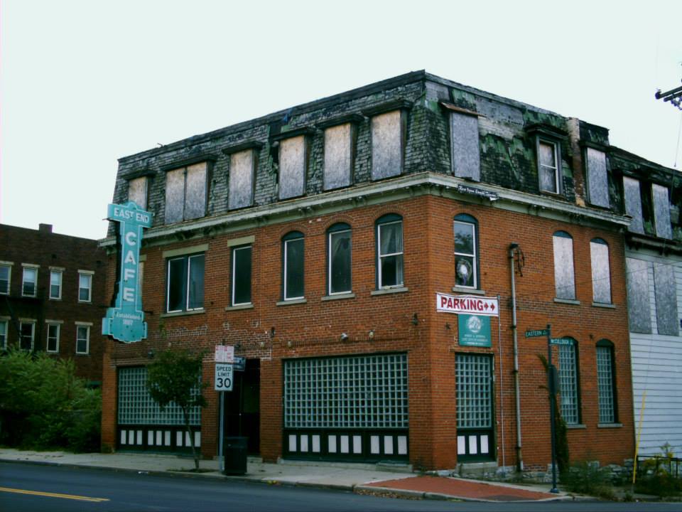
Columbia, OH (East End) (Columbia – Tusculum) – (1788 – present river, farming, and railroad town with a ghost town within the current community)
Classification: historic town
Location: City of Cincinnati (formerly in Spencer Township) – On Riverside Dr (US 52 / Kellog Ave) near the intersection of Wilmer Ave
Columbia was founded on November 18, 1788 by Revolutionary War veteran Major Benjamin Stites (1734 – 1804) who purchased 20,000 acres of land next to the mouth of the Little Miami River. He traveled with a group of 26 settlers down the Ohio River from Pennsylvania and started the first town in Hamilton County a month before Cincinnati (Losantiville) was settled. Columbia also went by the name of Turkey Bottom because of the 2 mile wide valley and fields next to the Ohio River that had an abundance of turkey and other game birds.
The town was initially just a cluster of log cabins around a few block storage houses, but it quickly grew to have 50 houses, a mill, and a school in 1790. The school was the first one in Ohio and the first school west of the original 13 colonies. It was run by John Reily (1763 – 1850), who was also a Revolutionary War veteran, as were most of the other men in the original group. The Columbia Baptist Church congregation also formed in 1790. They built the first church in Hamilton County in 1792. Reverend John Smith (1735 – 1824) was its minister and went on to be one of the first U.S. Senators from Ohio, serving from 1803 – 1808.
The biggest stories surrounding Columbia in the 1800s are that of its advancement of being a transportation hub. The only ways to get there in the early days were by canoe or flat boat on the Ohio River. Columbia had one of the earliest post offices in Ohio which ran by boat and horseback from 1819 – 1874. In 1835 the Anderson Turnpike wagon road connected Columbia with Cincinnati and Chillicothe. Then in 1841 the Little Miami Railroad swept through town. The Cincinnati, Georgetown, & Portsmouth Railroad had a line laid off of that in 1877 with the junction starting in Columbia and a train station on Carrell St. Cable cars were installed in 1890 and were operated by the Columbia Street Railway Co. The center of town moved north into the Tusculum hills due to flooding concerns of living near the river and the fact that Columbia flooded several times in the 1800s.
By 1900 Columbia acquired the name of East End, referring to it as the eastern edge of Cincinnati. Back then Columbia had several grocery stores, 3 hardware stores, 2 hotels, several saloons, a bank, theater, a restaurant, drugstore, and many other small businesses. The former Little Miami Railroad was bought out by the Pennsylvania Railroad in 1870. They had a station built on Torrence Rd off of Riverside Dr in 1907. It closed in 1933 and what’s left of it still sits on the railroad tracks between Riverside Dr and Columbia Parkway.
Edmund H. Lunken (1861 – 1944), a prominent local business man, proposed a 99 year renewable forever lease of 203 acres of his owned land in 1926 for an airport with the conditions that it be named after him and the city to escrow $60,000 for improvements prior to assignment. The lease was agreed to and signed by the mayor of Cincinnati in 1928. Lunken Airport is still in operation on Wilmer Ave. It has a museum operated by the Cincinnati Avaiation Heritage Society in Room 26 of the airport. A descendant of Edmund continues to hold onto the land deed and abide by the historic lease agreement. The family surname was originally Lunkenheimer, of German ancestry, and changed to Lunken in most of its branches during Edmund’s lifetime. He was laid to rest with relatives in Spring Grove Cemetery on Spring Grove Ave.
The town had another post office from 1927 – 1957. Columbia Baptist Church and Cemetery is across from Lunken Airport with parking in a small gravel lot off of Wilmer Ave. There are a few historical markers for the original site of Columbia in the cemetery where most of the early settlers were buried. A large column was built by the Baptist congregation in 1889 to commemorate their story. All four sides of the base of the column are engraved with info about them. In 1953 during the 150 year anniversary of Ohio’s statehood, a marker was placed at the front of the cemetery that tells the tale of Columbia’s early years.
Some other points of interest are original homes from the area including the Hezekiah Stites house (Benjamin’s son), built in 1835 at 315 Stites Ave, The James Morris house built in 1804 at 3644 Eastern Ave, and the Kellogg house built in the 1830s at 3811 Eastern Ave. The Columbia – Tusculum Historic District also operates a historic homes tour of the Victorian Era houses that were constructed in the Tusculum hills in the late 1800s and early 1900s. Another interesting sight is the Spencer Township Hall (township now defunct) that was built in 1860 at 3833 Eastern Ave. These days Cincinnati claims that Columbia – Tusculum is its oldest neighborhood, despite Columbia having a history all its own.
Thanks to Cliff Wartman of the Cincinnati Aviation Heritage Society for providing the info on Lunken Airport!
Town Website – https://www.columbiatusculum.org/
Clough, OH (Cluff) (Clough Valley) – (1790s – early 1900s farming town now considered to be part of Newtown)
Classification: ghost town
Location: Anderson Township, Hamilton County – On Clough Pike at the 4-way intersection of Corbly St and Hunley Rd along Clough Creek
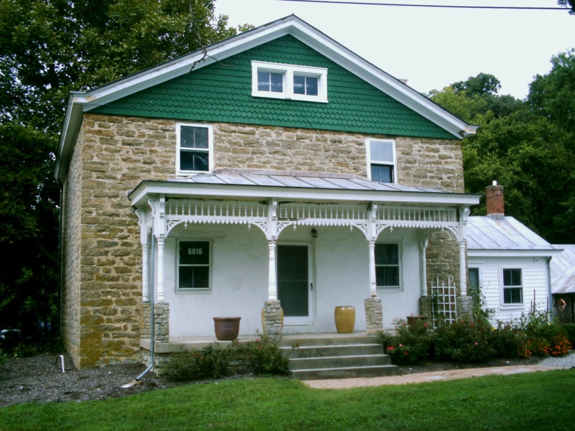
This old hamlet had a post office called Cluff from 1882 – 1905. It was settled in the late 1790s and was named after Revolutionary War veteran and surveyor Richard Clough Anderson (1750 – 1826). It doesn’t pop up on maps anymore and is considered to be in Newtown, although it’s probably closer to Mt. Washington. The Miller – Leuser Log House was constructed on land formerly owned by Revolutionary War Captain Matthew Jouitt, who was granted 600 acres of land for his service. One of his sons contacted Nathaniel Massie to sell the property after Matthew passed away in 1793. Ichabod Miller (1774 – 1839) and Sarah (Mercer) Miller (1767 – 1832) bought 400 acres of the land along Clough Creek in 1796.
Their cabin at the intersection of Bartles Road and Clough Pike was built sometime around that year. It was occupied for over 170 years and changed ownership several times. Joseph and Matilda Leuser bought the property in 1907. Their newlywed son Lawrence Leuser (1889 – 1964) and his bride Emma (Kuntz) Leuser (1889 – 1969) moved into the house in 1910 and spent over 50 years together there. The Anderson Township Historical Society purchased it in 1971 and conducted the restoration. The outside lot has a historical marker with more info, an old barn, restored wagon, a GEM water well pump, and the original water well has been reconstructed too.
Tours of the cabin are available on the first and third Sundays in June to October from 1 p.m. – 4 p.m. and can be requested to be open for private tours and school trips. Its furnished with antiques and has been on the National Register of Historic Places since 1974. As Anderson Township celebrated its 225th anniversary, the old buildings around Clough enjoyed some extra attention with events like walking tours and additional indoor activities. The town’s last school was built in 1874 at the intersection of Clough Pike and Goldengate Dr. It’s currently Clough Crossings Restaurant and features some historical exhibits and memorabilia from the area.
Over at the corner of Clough Pike and Hunley Rd, The Clark Stone House was constructed a few years after the Miller – Leuser Log House by Revolutionary War veteran and successful entrepreneur James Clark (1765 – 1852) and Savannah Clark (1765 – 1837). They moved to Ohio from Virginia and had 10 children. James was a justice of the peace and served in the state legislature. One of their sons, Orson, lived in the house until 1854 when he sold it Adam Leuser (1819 – 1905) and Juliana (Fink) Leuser (1825 – 1892), a couple of hopeful immigrants from Germany. Joseph Leuser, who bought the log cabin down the road, was one of their sons.
Genevieve (Leuser) Messmer (1894 – 1978) and Joseph Messmer (1891 – 1984) inherited the stone house in 1923. Joseph was a florist and built a greenhouse next it. Three of the Messmer daughters sold the house to Anderson Township in 1995. A historical marker was placed in the front yard in September of 2018. As with the log cabin, it also has an old barn on the property and several other old objects of local and historical interest. The Greenfield Plant Farm next to the stone house at 6840 Clough Pike continues on with the land’s agricultural tradition and promotes its heritage.
Many of the town’s residents and pioneers were buried in Clough Baptist Church Cemetery on Bridges Rd, right around the corner from Clough Pike. The gravestone of James and Savannah Clark is in the left side in the corner on top of the hill. More info on the town, church congregation, and former church building is displayed at the entrance. Ichabod and Sarah Miller were buried with relatives in Columbia Baptist Church Cemetery on Wilmer Avenue in Columbia -Tusculum. Most of the Leuser family was buried in Guardian Angels Cemetery on Salem Rd in Mt. Washington.

Dent, OH (Challensville) – (1843 – present former farming town partially abandoned over time)
Classification: small town
Location: Green Township, Hamilton County – On Harrison Ave south of I-74 and US 52
Dent was originally called Challensville and was named after the town’s first preacher, Rev. James Challen (1802 – 1878). The first house in town was the Three Mile Hotel which some of the early farmers in the area used as their residence. The Challensville post office ran from 1843 – 1846. Charles Gustav Reemelin (1814 – 1896) was a German immigrant and a state senator who lived in the town and had its name changed to Dent after a large depression in the earth near his house and vineyards. In its early days, Dent had a church, school, several stores, and a few dozen residences along Harrison Pike. The population was around 100 in 1895 and the post office ran from 1846 – 1904 when the mail started going through Cincinnati.
The town’s biggest claim to fame is the Dent Schoolhouse which was built in 1894. It’s said to be haunted by the ghosts of Charlie McFee (or McFree) and the children he killed. According to the legend, Charlie was a janitor at the school. Rumors of children disappearing in Dent began to circulate in 1942, but the story eventually lost its steam. However, 7 more children reportedly went missing in 1955 and the parents began to speculate about the strange smell that would occasionally rise from the basement.
Parents of the schoolchildren supposedly went down there and found the remains of a couple of dozen children hidden in the walls. Charlie the janitor was long gone, and although a reward was put out for his capture, he was never found or arrested. The school was closed shortly after that and has been converted into one of Ohio’s most popular haunted houses. It gets around 30,000 visitors every year during Halloween season. We’ve never seen any actual evidence of the school’s story being true, but it’s certainly interesting nonetheless.
The Dent Schoolhouse website – https://frightsite.com/

Five Mile, OH (Sweet Wine) (Sweetwine) – (early 1800s – early 1900s farming and mill town)
Classification: ghost town
Location: Anderson Township, Hamilton County – On Five Mile Rd between Markley Rd and US 52 along Fivemile Creek
Jacob Markely (1803 – 1879) and Emaline (Martin) Markley (1805 – 1870) donated land for Five Mile Chapel and Cemetery at 6977 Five Mile Road in Anderson Township. Jacob’s parents, John Markley (1769 – 1841) and Mary (Springer) Markley (1756 – 1837), spent time in Maryland, Pennsylvania, and Virginia before moving to Ohio. John constructed a saw mill next to Five Mile Creek and used the lumber it produced to build cabinets and flatboats. The boats were used to ship good from the area to towns on the Ohio and Mississippi rivers as far a New Orleans. Jacob and Emaline had 11 children and joined the family business. There was also a grist mill on the Markley farm and a school just east of the church.
A post office and store owned by Jacob and Emaline is pinpointed on the Anderson Township map in the 1869 county atlas on the south side of the intersection of Five Mile Rd and Kellogg Rd. The office was called Sweet Wine and was in operation from 1858 – 1904. It was named after the flourishing grape and wine industry along the Ohio River in the mid to late 1800s, with the steep hills heading away from the river valley being perfect for terracing and grape production. The office moved around to the homes of its postmasters after the Markley store closed. They were John B. Crance, John M. Vogel, Simon Troy, and Bertha Bridges.
The United Brethren congregation along Five Mile Creek built the church and officially established the cemetery in 1844. They used stones from the creek for the church construction with a limestone foundation and slate slab roof. Five Mile Chapel has undergone some remodeling. Its front doors originally faced John and Mary Markley’s graves. That changed when the bell tower was added in 1896 and the entrance moved to its base. Regular services ended in 1963 and it was added to the National Register of Historic Places in 1978.
The church and cemetery fell into disrepair for a while. Floods from the creek also damaged the building some over the years. It was adopted by the Five Mile Chapel Society who raised funds for repairs, maintenance, and upkeep. A creek wall was also constructed to prevent future flood damage. The cemetery is enclosed with a nice split log fence and has a historical marker for the Markley family. Events held at the church include an annual ice cream social and a Christmas gathering with carols and decoration making. The church also hosts around a dozen weddings every year and can seat 60 guests.
Sayler Park, OH (Home City) – Hamilton County (mid-1800s – present river and railroad town annexed into Sayler Park)
Classification: historic town
Location: City of Cincinnati, Hamilton County – On Home City Ave near the Ivanhoe Ave intersection
In 1900 Willliam J. Holthingrichs bought an ice company and changed the name to The Home City Ice & Coal Co. in 1910, naming it after the nearby neighborhood. Home city had its own train station on the Big Four Railroad (Cleveland, Cincinnati, Chicago, & St. Louis Railroad) and post office that ran from 1854 – 1911. The ice company was sold to Gottleib Hartweg who moved it to Ivanhoe Avenue in 1911. That same year Home City lost its name as Sayler Park was incorporated. There are still several remnants and old buildings left from when Sayler Park was Home City. It’s a nice area to spend a day along the Ohio river.

Hamilton County, Ohio Ghost Towns Research Resources
1847 – Hamilton County map
1856 – Hamilton County map
1869 – Hamilton County atlas
1884 – Hamilton County map
1914 – Hamilton County atlas
1881 – History of Hamilton County, Ohio
1882 – Historical Sketches and Early Reminiscences of Hamilton County, Ohio
1894 – History of Cincinnati and Hamilton County, Ohio
