

Featuring 4 towns with 12 pictures from Greene County, Restored Ohio was released on April 29, 2019. It’s the sequel of Abandoned Ohio (2018) and shows a different side of what physically remains of Ohio’s past. Many of the locations operate as businesses such as restaurants, hotels (former stagecoach stops), museums, and working mills.
Ordering Links
Arcadia Publishing – https://www.arcadiapublishing.com/Products/9781634991216
Amazon – https://www.amazon.com/Glenn-Morris/e/B07G8N3HP2/ref=ntt_dp_epwbk_0
Barnes & Noble – https://www.barnesandnoble.com/w/restored-ohio-glenn-morris/1129901378?ean=9781634991216
Walmart – https://www.walmart.com/ip/Restored-Ohio/185272799
Target – https://www.target.com/p/restored-ohio-by-glenn-morris-paperback/-/A-78016964
Bryson – Xenia Township
Location: 39.716644, -83.934934
on Old Springfield Pike between Kinsey Rd and US 68 along the Little Miami Scenic Trail
Remnants: none known
Description: The town was founded by James Bryson (1815 – 1911) from Pennsylvania and Nancy (Bradfute) Bryson (1828 – 1908) who owned a couple of large farms, were horse breeders, and donated land for the track path and a train station on the Pittsburgh, Cincinnati, Chicago, & St. Louis Railroad (Panhandle Route). They were buried with relatives in Woodland Cemetery on Dayton Ave in Xenia.
Caesars Creek (Cherry Grove) – New Jasper Township
Location: 39.679549, -83.78263
on Cherry Grove Rd between Old US 35 and Junkin Rd
Remnants: Caesar Creek (Cherry Grove) Cemetery at the GPS coordinates, former one-room schoolhouse in the northwest corner of the intersection of Cherry Grove Rd and Junkin Rd about 3/4 of a mile east of the GPS coordinates, old houses and farm buildings in the area
Description: This small farming and pioneer town was founded in the early 1800s. Known burials in the cemetery date back as early as 1810. On the 1855 county map, there was a Presbyterian church pinpointed across the road from the cemetery. The Cherry family is listed with 2 farms just south of the cemetery and the Junkin family had a saw mill along North Branch Caesar Creek. Irish immigrant and Revolutionary War veteran Lancelot Junkin (1753 – 1833) and Martha (Galloway) Junkin (1752 – 1830) were the patriarch and matriarch of the family in Ohio and were buried with relatives in the cemetery. The former one-room schoolhouse has been converted to a private residence and was on land donated by William Junkin (1818 – 1898) and Elizabeth (Walker) Junkin (1833 – 1921). They got married in 1858 and their former large 2-story residence still stands on Cherry Grove Rd just west of the school. William and Elizabeth were buried with relatives 3 3/4 miles southeast of the GPS coordinates in Old Silver Creek Cemetery on the east side of SR 72 in Jamestown. Another large 2-story wood frame house in the northwest lot of the intersection of Old US 35 and Cherry Grove Rd was originally owned by the Cherry family. Both of the houses were also pinpointed on the 1855 county map.
Caesarsville – Caesarscreek Township
Location: 39.618907, -83.891154
on US 68 at the intersection of Ireland Rd
Remnants: none known
Description: Founded in 1800 by War of 1812 veteran Thomas Carneal (1786 – 1860), Caesarsville was intended to be the future seat of Greene County. The town had a courthouse with a tavern along with some other public buildings and a public water well. The courthouse was used as the first voting place in the county. Xenia was granted the county seat in 1803 and the hopes of Ceasarville becoming a large town quickly faded away. At its peak, it had about 12 cabins and 30 residents. Thomas Carneal went on to be one of the original land proprietors of Cincinnati and one of the founders of Covington, Kentucky. He was buried with relatives in Spring Grove Cemetery on Spring Grove Ave in Cincinnati.
Harper – Silvercreek Township
Location: 39.660797, -83.764031
on Quarry Rd along Caesars Creek at the former railroad crossing between Old US 35 and Cottonville Rd
Remnants: former school at the intersection of Old US 35 and Quarry Rd
Description: The proprietors were Robert Harper (1810 – 1881) and Sarah Harper (1824 – 1882) who moved to Ohio from Virginia and owned an 85-acre farm on the west side of Jamestown. Harper was a flag stop on the Cincinnati, Hamilton, & Dayton Railroad in the late 1800s. The school was on land owned by the Meyers family. Robert and Sarah were buried with relatives in Woodland Cemetery on Dayton Ave in Xenia.
Huffersville (Kneisly Station) (Kniesleys) – Bath Township
Post Office: 1830 – 1831
Location: 39.818266, -84.074267
on SR 4 at the intersection of Bath Rd along Mad River
Remnants: Bath Presbyterian Church and Cemetery on the east side of Bath Rd north of the GPS coordinates
Description: Abraham Huffer moved to Bath Township from Lancaster County, Pennsylvania in the first decade of the 1800s and was the town’s postmaster. Simon S. Huffer (1813 – 1894) inherited part of the original homestead, as did Daniel S. Huffer (1819 – 1886) and Rosanna (Dice) Huffer (1834 – 1912). The town grew to have around 20 residences lining Mad River and Bath Rd. It was a farming town with a grist mill, saw mill, and a paper mill. Bath Presbyterian Church and Cemetery was established on land owned by James Chambers (1735 – 1819). He was buried with relatives in the cemetery. The first school, from the early to mid-1800s, was across the road from the cemetery and the second one, from the later 1800s, is now a private residence across from Kitridge Rd on the east side of Bath Rd. The area was also known as Kneislys Station. Daniel Kniesly (1823 – 1911) had a mill with a warehouse and train station across the river along the Mad River & Lake Erie Railroad in the early 1850s. The location was in the vicinity of the intersection of Bayou Rd and Symmes Rd in Wright-Patterson Air Force Base. In the early 1900s the town was called Kneisleys. Find A Grave has 3 interments listed in Huffersville Cemetery on private property in the northwest lot of the intersection at the GPS coordinates, but there doesn’t appear to actually be anything left of it. Simon Huffer was buried with relatives in Woodland Cemetery and Arboretum on Woodland Ave in Dayton, Montgomery County. Daniel Huffer was buried with relatives in Bellefontaine City Cemetery on E Brown Ave in Bellefontaine, Logan County.
Jayfield
Location: unknown
Description: It was on the Dayton & Wellston line of the B&O Railroad in the early 1900s.
Mechanicsville – Silvercreek Township
Location: 39.626090, -83.731009
on SR 72 at the 4-way intersection of Jasper Rd and Plymouth Rd
Remnants: none known
Description: Jonah Thomas (1807 – 1872) and Elizabeth Thomas (1817 – 1910) were the earliest known proprietors and ran a general store on the south side of Jasper Rd between SR 72 and Jamestown Gunnersville Rd. William Blain Jr. (1808 – 1857) and Lucinda Blain (1818 – 1856) owned a blacksmith shop and wagon shop over on the other side of SR 72 on the south side of Plymouth Rd. The town also had a school on the east side of Jamestown Gunnersville Rd about halfway between Jasper Rd and Carpenter Rd. Everyone mentioned in this listing was buried with relatives in Old Silvercreek Cemetery on S Sycamore St in Jamestown. Mechanicsville didn’t make it into the 1874 county atlas.
Mercers Station – Bath Township
Location: unknown
Description: The town was founded in 1796 by brothers Jonathan, Robert, and Edward Mercer (1769 – 1837) who moved to Ohio from Frederick County, Virginia and were the first settlers in the Greene County. The location of Mercers Station was in the vicinity of present-day Upper Valley Rd along the left bank of Mad River, approximately 1 1/2 miles southeast of the former location of Osborn. Edward was buried with relatives in Mercer Cemetery on the west side of SR 380 W Spring Valley Paintersville Rd and Peterson Rd in Spring Valley Township.
Old Chillicothe – Xenia Township
Location: 39.728693, -83.936845
on US 68 in Oldtown between the Little Miami River and Oldtown Creek
Remnants: a few historical markers for Old Chillicothe on the left side of the road at the GPS coordinates
Descpriton: Old Chillicothe was settled in 1774 along the Little Miami River and grew to be one of the Shawnee’s most important towns in the state. Chief Blackfish (1729 – 1779) was the leader of Old Chillicothe and Chief Tecumseh (1768 – 1813) was also raised there. It was abandoned in 1780 as George Rogers Clark (1752 – 1818) was heading up the Little Miami River toward the town with the Kentucky Militia while seeking retaliation for recent skirmishes south of the Ohio River.
Osborn – Bath Township
Post Office: 1855 – 1950
Location: 39.842184, -84.034997
on SR 235 at the intersection of Medway Rd (Osborn Rd) inside the gates of Wright – Patterson Air Force Base
Remnants: Cox Cemetery on the south side of Loop Rd east of the GPS coordinates
Description: Osborn was platted in 1851 by John Cox (1800 – 1882) and Samuel Stafford (1809 – 1897) about 1 1/2 miles northwest of Fairfield and was on the Mad River & Lake Erie Railroad. It was named after E. F. Osborn, the first railroad attendant, and flourished for 63 years partly due to taking on a railroad agreement which nearby Fairfield passed up. Osborn also had a grist mill, saw mill, and a distillery in its early years. The Great Flood of 1913 hit Dayton and the surrounding towns extremely hard. The Miami Conservancy District was formed to implement a flood project including several dams. Despite the fact that the area rarely flooded, Osborn was considered to be too close to the flood plain and the land was bought out by the Miami Conservancy District. The residents didn’t want to lose their town, so they moved it in a domino effect, people, buildings, and everything else closer to Fairfield. The Osborn Removal Company was formed and did much of the moving in the early 1920s. Just a few decades later in 1950, Osborn lost its name as it merged with Fairfield to create Fairborn. Some of the original buildings that were moved from Osborn can still be found in Fairborn today. John Cox was buried with relatives and early Osborn residents in Cox Cemetery and Samuel Stafford was buried with relatives in New Carlisle Cemetery at the intersection of SR 235 and Musselman Rd in Bethel Township, Clark County.
Pierces
Location: unknown
Description: none found
Silver Creek – Silvercreek Township
Location: unknown
Description: It was east of Jamestown.
Simms (Symmes) – Bath Township
Location: 39.808614, -84.074726
on Symmes Rd at the intersection of Prairie Rd in Wright – Patterson Air Force Base
Remnants: none known
Description: Simms had 2 train stations, one for passengers and another for freight, on the Bee Line of the Cleveland, Columbus, Cincinnati, & Indianapolis Railway. The town was on land owned by Samuel Stafford (1809 – 1897) who helped plat Osborn.
Transylvania – Spring Valley Township
Post Office: 1829 – 1843
Location: 39.606026, -84.014931
on Cook Rd between SR 725 and Centerville Rd
Remnants: none known
Description: This early Ohio town started up as a small hamlet in 1803, the same year Ohio became a state. It’s considered to be the original location of current day Spring Valley. The first settler in the area was Jeffery Truman (1794 – 1851) who built and operated a local tavern and was the town’s first postmaster. He married Jane (Elam) Truman (1810 – 1894). Farming and making supplies for wagons passing along what was then the Xenia – Cincinnati Pike were the main sources of income for the other residents. Spring valley, which was laid out in 1845 by the Walton family along the east side of the Little Miami river, was larger and growing much faster with mills and a copper shop. The remaining residents that were in Transyvlania moved across the river before 1850. Later in 1850, Samuel T. Owens surveyed Transylvania for 3 heirs of local families. They built 10 lots on the southwest bend of the Little Miami river but failed to attract new residents and Transylvania became a mere memory. Jeffery and Jane Truman were buried with relatives in Elam Cemetery on private property down a long lane on the east side of Elam Rd about 3/4 of a mile north of Spring Valley Paintersville Rd.
Valley Mills
Location: unknown
Description: It was listed on the 1898 railroad map and on the Ohio map in the 1901 George Cram atlas between Spring Valley and Xenia on the Pittsburgh, Cincinnati, Chicago, & St. Louis Railroad.
Winchester (Babtown) – Caesarscreek Township
Location: 39.566696, -83.902757
on Old Winchester Trail between New Burlington Rd and Lewis Rd
Remnants: none known
Description: It was stated in volume 1 of the 1918 History of Greene County, Ohio when speaking of Winchester that “there is no town in the county with a more artistic and finely-planned set of streets”. The town was platted with 72 lots and 16 outlots in 1816 by Thomas Babb Jr. (1766 – 1858) and Margaret (Wilson) Babb (1767 – 1840) who moved to Ohio from Winchester in Frederick County, Virginia. Despite the pretty plat on paper, they didn’t end up making a serious attempt to sell the lots or grow the town in any way. Thomas and Margaret were buried with relatives in Babb Cemetery on private property on the west side of Old Winchester Trail north of Mill Rd.

Alpha, OH – (1854 – present farming and mill town annexed into Beavercreek)
Classification: historic town
Location: Beavercreek Township, Greene County – On Alpha Rd between US 35 and Dayton Xenia Rd
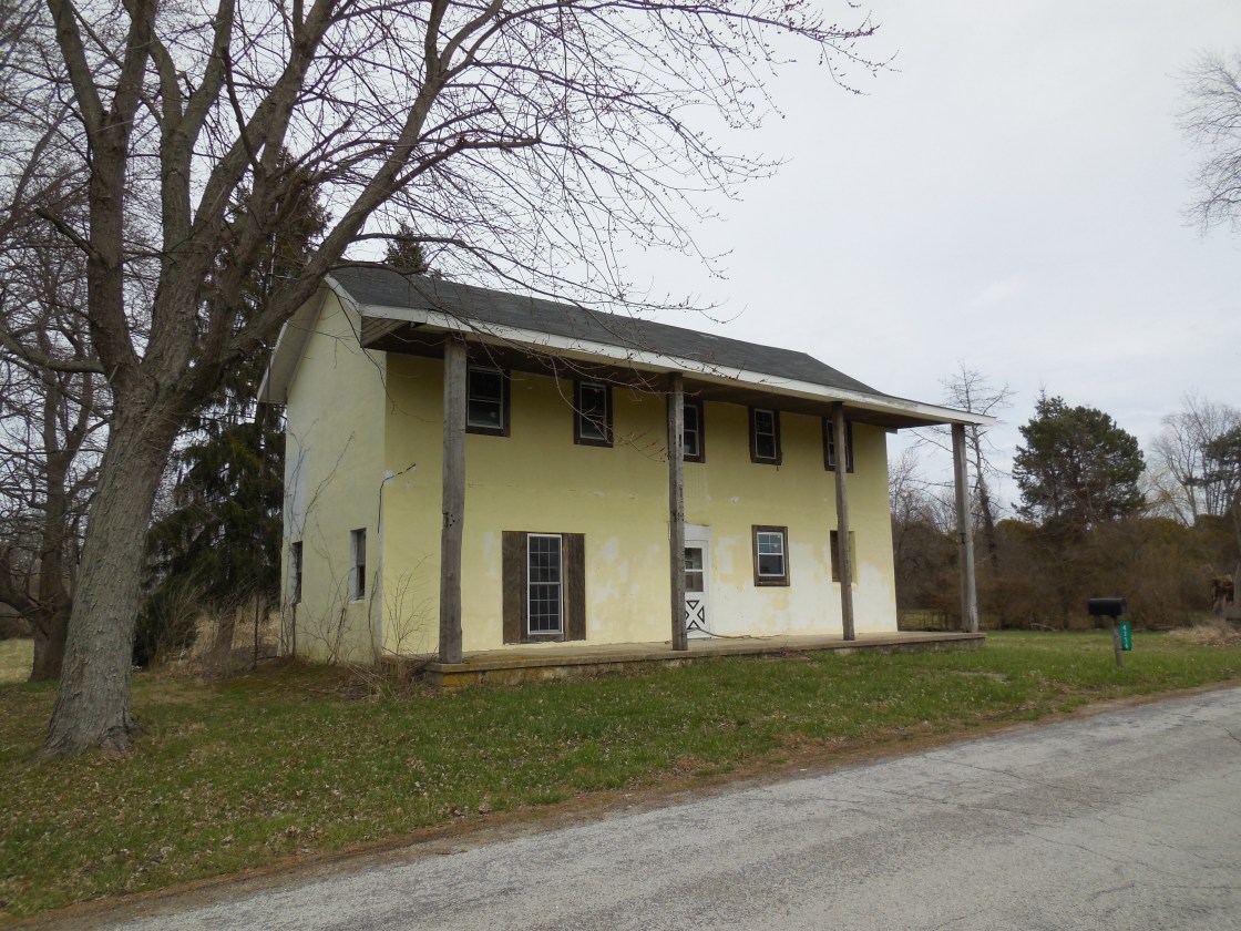
The story of Alpha is also the story of the founding of Green County. It was first settled in 1803 by General Benjamin Whiteman (1769 – 1852) and Catherine (Davis) Whiteman (1775 – 1852), along with her parents Owen Davis (1751 – 1818) and Letitia (Phillips) Davis (1750 – 1824). They all later moved and founded Clifton. Benjamin built a tavern in Alpha and Owen built a grist mill. They began to hold meetings in the tavern with a few nearby residents and ended up turning it into the first courthouse in the county. The meetings included the founding and layout of Greene County, which they named after General Nathaniel Greene, a local Revolutionary War hero.
Later in 1827, another couple from Pennsylvania, John T. Harbine (1804 – 1873) and Hetty Herr (Kauffmann) Harbine (1806 – ?), purchased the land that the mill and tavern were on. They employed many local residents and gave farmers more ways to process and sell their crops, mostly corn and tobacco. The Harbines and their children ran the grist mill, a saw mill, flour mill, wool mill, and a corn whiskey distillery. Alpha was aptly named as it was the first village in Beavercreek Township.
A post office was established in 1850. Tracks for the Panhandle line of the Pennsylvania Railroad and the Cincinnati, Hamilton, & Dayton Railroad arrived in the area in 1853. John Harbine donated land for a train station. In 1854 along with his friend William J. Needles, they decided it was time to officially put Alpha on the map and had it surveyed by Samuel T. Owens, the Greene County surveyor in Xenia.
Alpha was a fortunate town for its small size to have 2 railroads and a traction line, probably the biggest reason the area still has its name today while being squeezed on both sides by Beavercreek and Xenia. The residents also kept building with a church in 1872 and a meat market in 1874. The population grew to around 100 in 1918. John and Hetty Harbine’s last home is restored at 751 Alpha Rd and highlighted by Ohio Historical Marker # 21-29. The long gone old tavern and courthouse was in the front yard.
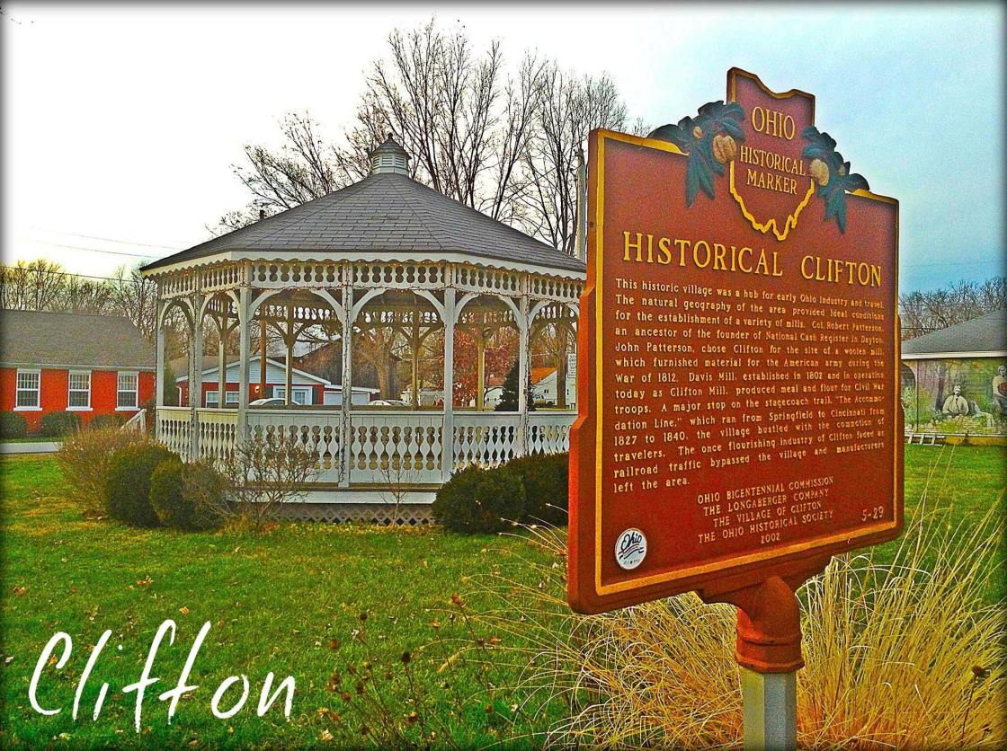
Clifton, OH – (1833 – present farming and mill town with little growth)
Location: Miami Township, Greene County and Green Township, Clark County – At the intersection of SR 343 and SR 72 (Springfield Jamestown Rd.)
Classification: historic town
Disgruntled that the Greene County seat was given to Xenia instead of Alpha, founded by the same family, Clifton was later founded by Owen Davis (1751 – 1818) and Laticia (Phillips) Davis (1750 – 1824) and their daughter and son-in-law Catherine (Davis) Whiteman (1775 – 1852) and General Benjamin Whiteman (1769 – 1852). Benjamin became a general in 1805 and served in the War of 1812.
In Clifton, Owen Davis built a mill and Benjamin Whiteman built a tavern, trading post, and a distillery in the first decade of the 1800s. The town quickly drew more settlers and was platted with 32 lots in 1833 by Timothy Bates and Bennet Lewis (1802 – 1876). They also donated land for the first church in Clifton and enlisted the services of a local carpenter, Abdael Kiler (1810 – 1891), to construct houses. He built 14 houses in summer of 1833 which were all bought that year. The town itself was said to be platted “square with the world”. We’re not exactly sure what that means, but if you take a closer look at it on the map, it’s easier to see why they said that. The name Clifton came from the rugged cliffs surrounding the Little Miami River in that area, sometimes reaching around 80 feet high. In its early days, Clifton had a blacksmith, saw mill, flour mill, a doctor, and a general store.
The town missed the railroad boom in the 1840s when the closest one was run through Yellow Springs 3 miles to the west, which was the first reason the population didn’t grow larger. The second reason came in 1849 when Clifton suffered from the worst Cholera epidemic of any town in Ohio based on its size. Half of the residents perished from it. Clifton bounced back some though and by 1918 the community had a town hall, jail, school, 2 stores, 3 churches, and an opera house that was fit to seat up to 500 people, good enough for a town twice its size. Clifton’s population was 152 in the 2010 census, far less than what its peak once was.
The town still has lots of old historical buildings including Benjamin and Catherine Whiteman’s original stone house and a restored mill on the same site as the one Owen Davis built. The current mill was originally built by Isaac Preston (1868 – 1950). The Davis family, Whiteman family, Abdael Kiler, and Isaac Preston are all buried in Clifton Union Cemetery on Tanyard Rd with relatives and many other early settlers.
Thanks to group member Brett Taylor, manager of Ohio Hiking Trails and Historical Sites, for providing the listing picture!
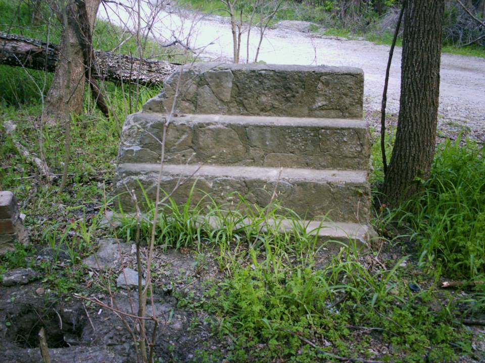
New Burlington, OH – (1803 – 1971 partially abandoned during the Caesar Creek Lake flood control project)
Classification: small town
Location: Spring Valley Township, Greene County and Chester Township, Clinton County – In Caesar Creek State Park on a gravel road (the old main street) just north of the intersection of SR 380 and Roxanna New Burlington Rd
New Burlington was first settled by Aaron Jenkins (1750 – 1807) who came from Tennessee in 1799. He donated land for the cemetery and was the first person buried there. New Burlington hit its peak population around 400 residents in 1880. The town had a few churches, a post office that ran from 1837 – 1971, and a train station on the Columbus, Washington, & Cincinnati Railroad (Grasshopper) from 1878 – 1933. It also had several grocery and general stores over the years as well as everything else the town needed at any given time, including a shoe shop, tailor, tannery, blacksmith, saw mill, planning mill, school, and 2 doctors in the late 1800s.
The last grocery store that existed was located across from where a small set of concrete steps still stand, about 10 feet from the right side of the old main street. The gravel road turns into a concrete road and the main street bridge is the next sight to see. There are plenty of parking spots on the other side.
Some barely visible foundations are in the area and occasionally other objects left behind can be found. During one of our expeditions, we came across a very old 7 ounce soda bottle made by the Star City Bottling Co. of Miamisburg, OH and a nickel hinge from an ice box in a decaying parking lot in the woods. Lawrence Mitchner (1886 – 1973) and Ethel (Compton) Mitchner (1894 – 1964) were the last remaining residents who wouldn’t sell off their land in town before the flood control project began. They are also buried in the cemetery. New Burlington is still a populated area but its center has moved south a bit.
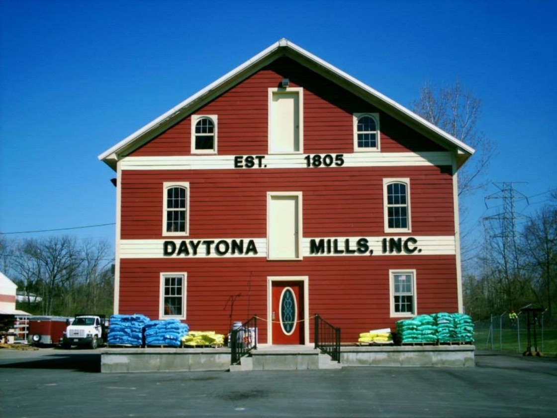
Shoup’s Station, OH – (1805 – early 1900s farming, mill, and railroad town annexed into Beavercreek)
Classification: ghost town
Location: City of Beavercreek, Greene County – On Old Mill Ln off of N Fairfield Rd
Solomon Shoup (1788-1812) was born into a family of millers from Maryland. He constructed Daytona Mills in 1805 along Little Beaver Creek 2 miles west of Alpha on a disbanded section of Old Mill Ln off of N Fairfield Road. It started out as a flour mill and is now a popular hardware store. The rebuilt mill was originally on the south side of the creek and was moved to the north side in 1921. Shoup’s Station had a train station on the Dayton & Xenia Railroad with a general store and around 15 residents. Solomon was buried with many relatives in Mt. Zion Shoup Cemetery at the intersection of N Fairfield Rd Indian Ripple Rd.
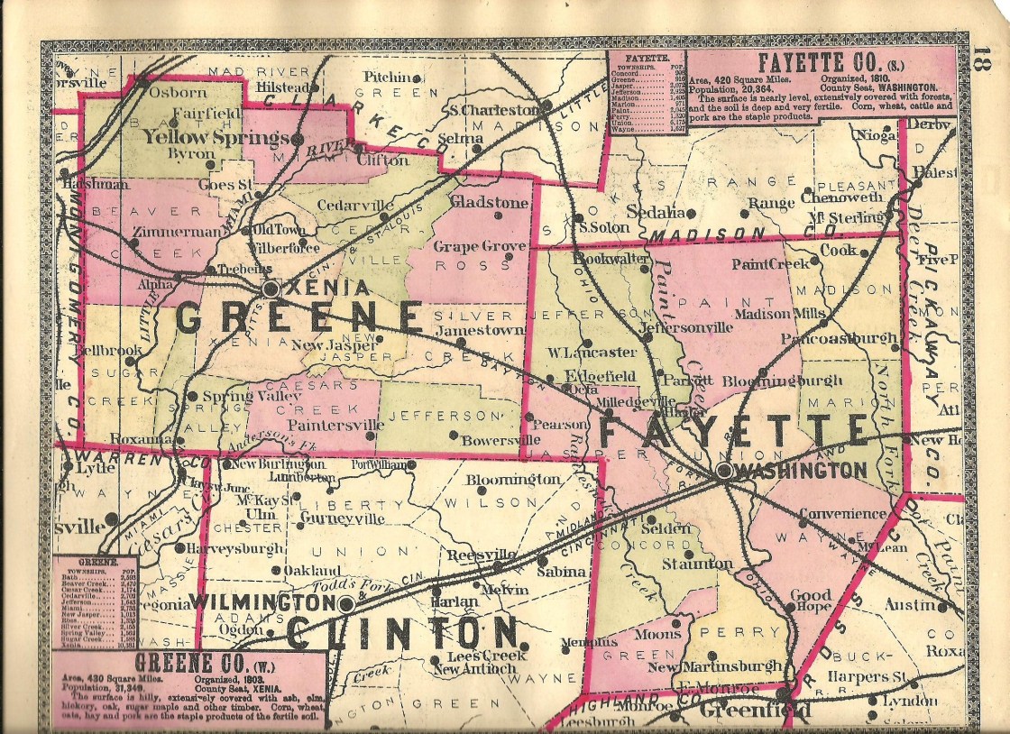
Greene County, Ohio Ghost Towns Research Resources
1855 – Greene County map
1874 – Greene County atlas
1896 – Greene County atlas
1881 – History of Greene County
1890 – Portrait and Biographical Album of Greene and Clark Counties, Ohio
1902 – History of Greene County, Ohio
1918 – History of Greene County, Ohio – Vol. 1
1918 – History of Greene County, Ohio – Vol. 2
