

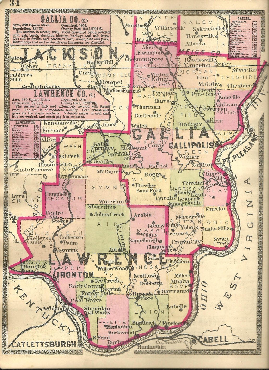
Angola – Clay Township
Post Office: 1890 – 1914
Location: 38.693873, -82.191225
on SR 7 (Ohio River Scenic Byway) at the 4-way intersection of Teens Run Rd and Old Dam 26 Rd (Township Hwy 650) along the Ohio River
Remnants: McLellon Cemetery on the north side of Teens Run Rd 1/4 of a mile west of the GPS coordinates, Clay Chapel Cemetery 1/2 of a mile north of the GPS coordinates at the intersection of SR 7 and Clay Chapel Rd (County Rd 96)
Description: Angola, along with the vast majority of Gallia County’s ghost towns, was a farming, livestock raising, and postal town. George H. Bashore (1863 – 1893) was the first postmaster. He was succeeded by one of his brothers, Jacob A. Bashore (1849 – 1912). They were both Freemasons and were buried with relatives and other residents in Clay Chapel Cemetery. The cemetery was officially established in 1853. McLellon Cemetery dates back to at least the 1820s. It was named after James McLellon (d. 1865) and Esther (Stone) McLellon (1810 – 1838) from Pennsylvania.
Boggs – Walnut Township
Post Office: 1880 – 1905
Location: 38.745775, -82.367555
on SR 775 at the intersection of Hannan Trace Rd along Sand Fork
Remnants: Bethesda Church a mile south of the GPS coordinates at the other intersection of SR 775 and Hannan Trace Rd, Bethesda Cemetery on the east side of SR 775 just north of the church, old houses and farm buildings in the area
Description: Boggs was a farming and livestock town. James Ansley Boggs (1843 – 1889) was the first postmaster. He served in the National Guard during the Civil War and was also a township treasurer. James married Matilda (Waugh) Boggs (1848 – 1937) in 1877 and had 5 children. His parents, James Boggs (1788 – 1869) and Mary (Williams) Boggs (1806 – 1888) were early pioneers in the county. Civil War veteran Stephen E. Niday (1841 – 1919) was the second postmaster. He married a sister of James, Elizabeth (Boggs) Niday (1847 – 1902). They had at least 9 children. The town had a couple more postmasters before it closed. Everyone mentioned in this listing was buried in Bethesda Cemetery. It was established in 1832 on land owned by the Williams family.
Bull Skin – Harrison Township
Post Office: 1836 – 1842
Location: unknown
Description: It was along Bullskin Creek with Cornelius Holley (b. 1794) from Virginia as the postmaster. The family surname is also spelled Hawley or Halley in some branches.
Chapmans Mills – Guyan Township
Post Office: 1872 – 1895
Location: 38.604202, -82.313324
on SR 218 at the intersection of Williams Creek Rd (County Rd 190) at the confluence of Indian Guyan Creek and Williams Creek
Remnants: Chapman Cemetery on private property on the north side of Williams Creek Rd about 3/4 of a mile west of the GPS coordinates, Good Hope United Baptist Church and Cemetery about 1/2 of a mile north of the GPS coordinates on Good Hope Rd
Description: The town was founded by county pioneers Archibald Chapman (1787 – 1870) from Montgomery County, Virginia and Elizabeth (Mills) Chapman (1787 – 1857) from Essex County, Massachusetts. They had a few children and the post office was established by the family’s second generation. Isaac Chapman (1812 – 1878) was the first postmaster. He was buried with relatives, including his parents, in Chapman Cemetery. Elijah F. Williams (1848 – 1917) was the last postmaster. He married Ellen Chapman (1854 – 1908) and was buried in Good Hope Cemetery. The church was established in 1895.
Charity – Morgan, Cheshire, Addison, and Springfield Township
Post Office: 1889 – 1904
Location: 38.940033, -82.223388
on White Oak Rd (County Rd 19) at the intersection of Nibert Rd (Township Hwy 325) along Little White Oak Creek
Remnants: Campaign Cemetery 1 1/2 miles south of the GPS coordinates on the north side of White Oak Rd, Wilt Cemtery on the north side of White Oak Rd west of Thaxton Rd, old houses and farm buildings in the area
Description: William Malaby (1831 – 1907) was the first proprietor and postmaster. He owned an 85-acre farm on Nibert Rd in Morgan Township at the Cheshire Township border and an 80-acre farm on White Oak Rd in Springfield Township at the Morgan Township border. William was married twice, had about a dozen children, and was buried with relatives in Campaign Cemetery in Addison Township. Civil War veteran David Wilt (1830 – 1906) was the next postmaster. He was buried with relatives in Wilt Cemetery in Morgan Township. Isaiah Thomas (1860 – 1957) was the last postmaster. He was laid to rest with relatives 4 miles northeast of the GPS coordinates in Poplar Ridge Cemetery on the southeast side of Poplar Church Rd in Cheshire Township.
Chestnut Grove – Huntington Township
Post Office: 1870 – 1905
Location: 38.994372, -82.392184
on Keystone Rd (County Rd 143) at the intersection of Jones Rd
Remnants: Wilcox Cemetery at the end of Wilcox Cemetery Rd east off of Jones Rd about 1/2 of a mile north of the GPS coordinates
Description: The proprietors were Stephen Wilcox Jr. (1817 – 1885) from New York and Rebecca (Butler) Wilcox (1821 – 1898). They married on the 4th of July in 1840 and had at least 6 children. Stephen was the first postmaster and Rebecca took on the position after he passed away. William S. Welker (1851 – 1930) was the last postmaster. Everyone mentioned in this listing was buried with relatives in Mount Tabor Cemetery 4 miles southeast of the GPS coordinates on the south side of Mt Tabor Rd (County Rd 89).
Clemma – Ohio Township
Post Office: 1890 – 1907
Location: 38.630297, -82.199821
on Swan Creek Rd (County Rd 152) at the intersection of Horse Creek Rd (Township Hwy 862) along Swan Creek
Remnants: Liberty Chapel on the west side of Swan Creek Rd about 1/2 of a mile north of the GPS coordinates, old houses and farm buildings in the area
Description: Joab A. King was the first postmaster. He was succeeded by James F. Rose. The original Liberty Chapel was constructed in 1887 but was destroyed by a fire before its dedication ceremony. The congregation purchased a former one-room schoolhouse at the site of the present church and worshiped in that until the current structure was completed in 1913.
Creuzet – Guyan Township
Post Office: 1887 – 1905
Location: unknown
Description: It was in the western half of the township. Jacob Lindewood (1854 – 1929) was the first postmaster. He married Charinda (Swain) Lindewood (1856 – 1925) and moved to out of the state. Jacob and Charinda were buried with relatives in IOOF Cemetery on E Cole St in Du Quion in Perry County, Illinois. John Linderwood (1851 – 1914) was the second postmaster. He also moved to Illinois and was buried with relatives in IOOF Moweaqua Township Cemetery on Putnam Rd in Shelby County. Oscar Russell was the last postmaster.
Domino – Addison Township
Post Office: 1889 – 1901
Location: 38.917416, -82.202820
on Possum Trot Rd at the intersection of Blazer Rd (Township Hwy 311)
Remnants: Rife Cemetery 1 1/2 miles south of the GPS coordinates on Rife Cemetery Rd on the east side of Addison Pike
Description: The proprietors were Nathan Rife (1826 – 1911) and Elizabeth (Darst) Rife (1828 – 1901). They got married in 1849, had at least 8 children, and were laid to rest in Rife Cemetery.
Edna – Huntington Township
Post Office: 1884 – 1903
Location: 38.972515, -82.408472
on Coal Valley Rd (Co Rd 141) between Scott School Rd (County Rd 139) and Sherman Rd at the confluence of Keeton Run and Raccoon Creek
Remnants: Brush Cemetery about 4 miles south of the GPS coordinates at the intersection of Mt Tabor Rd (County Rd 89) and Scott School Rd
Description: The town had a couple of local schools. Huntington Township School No. 8 was on the south side of Keeton Run on a long gone road and Huntington Township School No. 9 was on Sherman Rd north of Brush Cemetery. There was also a church at the cemetery. George W. Bodekin was the first postmaster. He was succeeded by George C. Hartsook (1842 – 1917). George married Sarah (Deckard) Hartsook (1840 – 1915) in 1861 and had a few children. They were buried with relatives in Brush Cemetery. The post office moved to the intersection at Brush Cemetery in 1901. Julius N. Deckard (1834 – 1917), a cousin of Sarah, was the last postmaster. He married Eliza (Price) Deckard (1840 – 1905), had at least 6 children, and was also buried in Brush Cemetery.
Esop – Raccoon Township
Post Office: 1884 – 1905
Location: 38.929443, -82.412421
on Mt Carmel Rd at the 4-way intersection of Mt Tabor Rd and Corn Rd (Township Hwy 589)
Remnants: Ebenezer Church and Cemetery on Mt Carmel Rd just northwest of the intersection
Description: Evan L. Evans was the first postmaster. He was succeeded by Amos Deckard (1873 – 1962). Amos married Mary Jane (Sharp) Deckard (1876 – 1966) later moved to Franklin County and was buried there with relatives in Union Cemetery at the intersection of Olentangy River Rd and W Dodridge St.
Halley – Ohio Township
Post Office: 1892 – 1907
Location: 38.653036, -82.229441
on Bladen Rd (County Rd 170) at the intersection of Layne Rd (Township Hwy 860)
Remnants: old houses and farm buildings in the area
Description: Thomas J. Halley (1854 – 1912) was the first postmaster. He married Lenora (Burnett) Halley (1853 – 1934) and was buried with relatives 3 1/2 miles west of the GPS coordinates in Mercerville (Old Mercerville) Cemetery on Mercerville Cemetery Rd. Hilas Russell Johnson (1842 – 1918) was the last postmaster. He married Caroline (Clark) Johnson (1842 – 1915), had at least 7 children, and was buried with relatives 3 1/2 miles north of the GPS coordinates in Providence Cemetery on the north side of Teens Run Rd in Clay Township.
Hilton – Harrison Township
Post Office: 1891 – 1912
Location: 38.731169, -82.285316
on Little Bullskin Rd at the intersection of Clay Lick Rd (Township Hwy 702)
Remnants: Macedonia Church and Cemetery on Clay Lick Rd about 1/4 of a mile west of the GPS coordinates, old houses and farm buildings in the area
Description: Hugh George Hardway (1869 – 1922) was the first postmaster. He married Mary (Shuler) Hardway in 1900. Hugh and Mary moved around the country a few times, had 5 children, and were buried with relatives in Des Moines Cemetery on 2nd St in Des Moines in Union County, New Mexico. John A. Calhoun (1867 – 1909) was the next postmaster. He was buried with relatives about 8 miles north of the GPS coordinates in Centenary Cemetery on Centenary Church Rd in Green Township. Owen Boster (1882 – 1969) was the last postmaster and was buried with relatives in Macedonia Cemetery.
Hollis – Harrison Township
Post Office: 1903 – 1912
Location: 38.720475, -82.324796
on Lincoln Pike (County Rd 20) at the intersection of Carter Rd (County Rd 20) along Claylick Run
Remnants: none known
Description: Civil War veteran Ansel Evan Kerns (1844 – 1913) was the proprietor and postmaster. He married Lurana (Thierry) Kerns (1850 – 1883) and had a few children. They were laid to rest with relatives in Dickey Chapel Cemetery 2 1/2 miles south of the GPS coordinates at the intersection of Hannan Trace Rd and Elliott Rd (Township Rd 726).
Lincoln – Harrison Township
Post Office: 1862 – 1905
Location: 38.711010, -82.340321
on Lincoln Pike (County Rd 20) at the intersection of Hannan Trace Rd
Remnants: Lincoln Pike Chapel Cemetery about 1/3 of a mile north of the GPS coordinates on the north side of Boggs Rd (County Rd 122), old houses and farm buildings in the area
Description: Lincoln was a farming town with a village surrounding the area at the GPS coordinates. Charles Stewart was the first postmaster. There were a few other postmasters over the decades, including Joseph B. Walter (1859 – 1952) who was the last. Despite having lost its post office, Lincoln made it onto the 1910 county map before fading into obscurity in the mid-1900s. Joseph was buried with relatives in Lincoln Pike Chapel Cemetery.
Mattie – Guyan Township
Post Office: 1892 – 1905
Location: 38.666644, -82.334670
on a long gone stretch of road east of New Sheets Cemetery which ran from north to south between current-day SR 790 and Johns Creek Rd
Remnants: New Sheets Cemetery (Sheets Cemetery #1) on New Sheets Cemetery Rd at the GPS coordinates
Description: Andrew Jackson Johnson (1835 – 1922) was the postmaster. He married Diana (Rankin) Johnson (1839 – 1874) and had at least 2 children. One of their daughters, Nancy (Johnson) Sheets, married Gory Jasper Sheets (1863 – 1939) and had 14 children. 6 of their sons served in World War I. Lewis M. Sheets (1847 – 1912) suceeded Andrew as postmaster. Lewis was a school teacher for 40 years and served as township recorder and assessor. He married Nancy (Drummond) Sheets (1850 – 1922) in 1863, had 9 children, and was buried with many relatives in New Sheets Cemetery. Andrew and Diana were buried with relatives in Mercerville (Old Mercerville Cemetery) about 5 miles east of New Sheets Cemetery.
McCormick – Green Township
Post Office: 1897 – 1912
Location: 38.834754, -82.283565
on Vanco Rd (County Rd 14) at the intersection of Centenary Rd (County Rd 10)
Remnants: none known
Description: The town had a church in the southeast corner of the intersection of SR 588 and Centenary Rd and was named after the McCormick family which owned around 1,000 acres of the land in the area in the mid to late 1800s. Melzar N. Magnet (1846 – 1935) was the first postmaster. He moved to Scioto County and was buried in Greenlawn Cemetery on Offnere St in Portsmouth. Carrie Belle (Mills) McCormick (1877 – 1975) was the next postmaster. She married Cyrus McCormick (1875 – 1955), had a few children, and moved to Delaware County where she was buried with relatives in Sunbury Memorial Park on West Cherry St. Mary A. Riggs was the last postmaster.
Moody – Harrison Township
Post Office: 1881 – 1907
Location: 38.706278, -82.303804
on Little Bullskin Rd between Carter Rd (County Rd 120) and Woodie Rd
Remnants: Mt Carmel Cemetery on private property on the north side of Little Bullskin Rd at the GPS coordinates
Description: Civil War veteran John Warren Irion (1843 – 1923) was the first postmaster. He was married twice, had several children, and was buried with relatives and other residents of Moody in Mt Carmel Cemetery. Cornelius C. Neal (1853 – 1935) was the second postmaster and was buried in Mt Carmel Cemetery. Erastus E. Clark (1872 – 1957) was the next postmaster. He was buried in Macedonia Cemetery about 2 1/2 miles north of the GPS coordinates on the north side of Clay Lick Rd (Township Hwy 702). Civil War veteran Phillip A. DeWitt (1844 – 1929) was the last postmaster and was also laid to rest in Mt Carmel Cemetery.
Obal – Huntington Township
Post Office: 1890 – 1905
Location: 38.962453, -82.374567
on Mt Tabor Rd (County Rd 89) at the intersection of Coal Valley Rd (Co Rd 141)
Remnants: Little Pearl Church and Mt Tabor Cemetery on the south side of Mt Tabor Rd about 3/4 of a mile southwest of the GPS coordinats, old houses and farm buildings in the area
Description: Obal had a school (Huntington Township No. 5) in the northwest corner of the intersection. The church at the cemetery was originally called Tabor and is presently called Little Pearl Church Of Old Regular Baptists. William Lewis (1835 – 1926) was the first postmaster. He was buried with relatives in Brush Cemetery about 2 miles southwest of the GPS coordinates at the intersection of Mt Tabor Rd and Scott School Rd (County Rd 139). The last postmaster was Civil War veteran William A. Louks (1841 – 1908). He married Eunice (Jacobs) Louks (1846 – 1926), had several children, and was buried with relatives and other residents in Mt. Tabor Cemetery. William was unfortunately killed by a skull fracture from a heavy branch that fell while he was chopping down trees on his farm along Raccoon Creek.
Prospect Hill – Springfield Township
Location: 38.898852, -82.244401
on White Rd at the intersection of Prospect Church Rd (County Rd 31)
Remnants: Prospect Church and Cemetery on Prospect Church Rd about 1/4 of a mile northwest of the GPS coordinates
Description: Prospect Hill was named after the local hill’s summit which is over 900 feet. The cemetery behind the church dates back to the late 1800s.
Providence (Smiths) – Clay and Harrison Township
Post Office: 1904 – 1907
Location: 38.683251, -82.269973
on SR 218 at the intersection of Teens Run Rd at the confluence of Bullskin Creek and Rodlick Creek
Remnants: Providence Church and Cemetery on the north side of Teens Run Rd a mile east of the GPS coordinates, Smith Cemetery on the east side of SR 218 about 1/2 of a mile north of the GPS coordinates
Description: Providence grew around its Baptist church congregation which formed in the early 1820s. The area was originally called Smiths, named after a local family. The first church structure was built on land donated by William Smith (1786 – 1849) and Margaret (Wough) Smith (1794 – 1860) from Virginia. It was a log building near the GPS coordinates and was destroyed by a fire in 1826. A new wood frame church at the present site was completed in 1852 on land donated by the Clark family. It suffered the same fate as the first church in 1887. Construction of the current church structure began the following year and it was dedicated in October of 1890. William Curtis Clark (1874 – 1939) was the town’s postmaster. The office was in section 7 of Harrison Township on the east side of SR 218. William married Sarah (Carter) Clark (1876 – 1957) and had a couple of children. They were buried with relatives and other residents in Providence Cemetery. William and Margaret Smith were buried with relatives and other early residents in Smith Cemetery.
Rosebud
Location: unknown
Description: The only reference to Rosebud that could be found was an obscure listing in the 1920 book The Ohio River: Charts, Drawings, And Description Of Features Affecting Navigation at a distance of 282.1 miles below Pittsburgh.
Ruby – Harrison Township
Post Office: 1899 – 1905
Location: 38.678919, -82.333568
on Martt Rd between SR 790 and Elliott Rd (Township Rd 726)
Remnants: Martt Cemetery on private property the west side of Martt Rd about 1/3 mile south of the GPS coordinates on the Harrison and Guyan Township border, old houses and farm buildings in the area
Description: Rufus W. Houck (1875 – 1903) was the first postmaster. He was buried with relatives in Dickey Chapel Cemetery about 2 miles northeast of the GPS coordinates at the intersection of Elliott Rd and Hannan Trace Rd. The Martt and Houck families were related by marriage.
Siloam – Perry Township
Post Office: 1912 – 1928
Location: 38.805705, -82.372677
on SR 141 at the intersection of Maple Grove Rd along Raccoon Creek
Remnants: old houses and farm buildings in the area
Description: The post office moved north to Cora in 1922.
Tynrhos (Tyn Rhos) – Perry and Raccoon Township
Location: 38.853878, -82.412844
on Tyn Rhos Rd (Co Rd 46) between Cherry Ridge Rd and Centerpoint Rd
Remnants: Tyn Rhos Church and Cemetery at the GPS coordinates
Description: The town was founded by David Thomas and Jessie Dinah (Gray) Thomas who moved to the U.S. from Wales and settled in Gallia County in 1837. It was named after the farm David was born on in Wales, which is still in existence, and translates to “house on the moor”. David and Jessie donated land for the church and cemetery. The original log structure was completed in 1841 and was the first Welsh church in the state. It was replaced by the current wood frame building in 1850. The present church was restored in 1970 and has a historical marker with more info. A replica of the original log church is also at the site. The ghost town sits along the Welsh Scenic Byway, a 64-mile route through Gallia and Jackson County which highlights the heritage of the Welsh culture in southeast Ohio.
Wigner – Green Township
Post Office: 1885 – 1906
Location: 38.784903, -82.333234
on Northup Rd (County Rd 22) along Raccoon Creek between SR 775 and Ingleside Camp Rd (Township Hwy 398)
Remnants: none known
Description: James A. Smeltzer (1868 – 1945) was the proprietor and postmaster. He married Esta (Rader) Smeltzer (1875 – 1922) and was buried with many relatives in Mound Hill Cemetery on SR 141 in Gallipolis.
Cheshire, OH – (1820s – present farming and mining town partialy abandoned in 2002 during a buyout by the Kyger Creek Power Plant)
Classification: semi-ghost town
Location: Cheshire Township, Gallia County – On SR 554 at the intersection of SR 7 near the Ohio River
Cheshire was settled in the early 1800s and became a town in the 1820s with a post office that started up in 1826. 27 lots were plotted for the town’s growth and the first school was built in 1835. Farming was its biggest source of income for several decades as crops were floated on the Ohio River from Cheshire to as far as New Orleans. Coal was later discovered in the area and Cheshire got a train station on the Hocking Valley Railway. It also had a hotel, several stores, a church, flour mill, and a barrel factory.
In 1863, 2500 Confederates on horseback swept through the town during Morgan’s Raid. The hotel and school dorm were used to house captured soldiers. In 1913 and 1937 Cheshire was devastated by Ohio River floods but the town survived both times. The James M. Gavin (Kyger Creek) Power Plant was built on the west side of Cheshire in 1975. Several old homes and businesses were demolished for its construction. The residents of Cheshire were exposed to soot raining down from the power plant smokestacks and some suffered unhealthy side effects.
Rather than face numerous lawsuits, the power plant owners proposed a buyout of the town in 2002 and offered the residents money to move out of Cheshire. Some left and some stayed, vowing that they would never leave no matter how much they were offered. More homes and businesses were demolished, but In 2004 Cheshire annexed some property to the north and west in the hopes that the town will have a brighter future. The town’s population was 132 as of the 2010 census. Cheshire still has several old buildings in the area.
Glenn, OH – (early 1800s – 1930s farming and mill town with less residents than in the past)
Classification: ghost town
Location: Huntington Township, Gallia County – On SR 325 south of Vinton
It was settled by a couple from Virginia in 1805 on the banks of Raccoon Creek. William Glenn (1763 – 1838) and Ann (Curry) Glenn (1768 – 1850) had 13 children and built the first church in 1829. William owned an ox ranch with Samuel R. Holcomb, who went on to lay out the town of Vinton. The Glenn’s children continued to farm, run cattle ranches, build mills, and employ other residents in the area. In the mid to late 1800s, the family donated land for a train station on the Hocking Valley Railway. The town had a post office from 1890 – 1933. Many residents moved away when the railroad went out business. Glenn Cemetery is a half mile south of Vinton off of SR 325. It’s on the same gravel road as Holcomb Cemetery.
Vinton, OH – (1832 – present farming, mill, and iron town partially abandoned over time)
Classification: small town
Location: Huntington Township, Gallia County – On SR 325 at the intersection of SR 160
Vinton was laid out in 1832 by General Samuel R. Holcomb, a former member of the U.S. House of Representatives. It was named after an early settler in the area, Samuel Finley Vinton, the same man Vinton County is named after. The town quickly flourished and a post office was established in 1835. Vinton became a target for Confederate soldiers who heavily ransacked it in 1863. The event came to be known as Morgan’s Raid and is currently detailed by Ohio Historical Marker # 16-27 in front of the post office at the corner of SR 160 (Jackson St) and N Main St.
The Columbus, Hocking Valley, & Toledo Railroad rolled through in 1880 and Vinton had a population and industry boom like most other railroad towns. Iron ore was their main source of income for a long time, but the mines eventually stopped producing and the railroads left. Vinton has struggled to maintain its citizens since then due to the lack of economic opportunities. It also had bad floods in 1937, 1968, and 1997 which was another reason why some residents left. The population was at 324 in the 2000 census. Holcomb Cemetery is a half mile south of Vinton off of SR 325. It’s on the same gravel road as Glenn Cemetery.
Gallia County, Ohio Ghost Towns Research Resources
1874 – Gallia County atlas
1910 – Gallia County map
1882 – History of Gallia County
