Alum Creek – City of Columbus (formerly in Montgomery and Marion Township)
Post Office: 1894 – 1915
Location: 39.979742, -82.957653
on Leonard Ave at the railroad junction heading south along Alum Creek
Remnants: none known
Description: Alum Creek had a train station on the Columbus, Sandusky, & Hocking Railroad, later bought by the Big Four (Cleveland, Cincinnati, Chicago, & St. Louis Railroad). The creek itself was the site of many early settlements and mills in the county and around Columbus. It was named after the metallic substance that was found in slate slabs on the creek banks. The town’s post office was called Leonard.
Avenue – Franklin Township
Post Office: 1874 – 1905
Location: 39.941805, -83.111996
on Georgesville Rd at the intersection of Sullivan Ave
Remnants: none known
Description: In the 1880s the post office was on land owned by Newell Mix (1835 – 1889) and Emaline (Deforest) Mix (1838 – 1886). Newell was a justice of the peace in Franklin Township. The town also had a train station on the Cincinnati, Sandusky, & Cleveland Railroad, later bought by the Big Four. Newell and Emaline had a few children and were buried with relatives in Green Lawn Cemetery on Greenlawn Ave.
Baker Hill – City of Columbus (formerly in Hamilton and Marion Township)
Location: 39.906343, -82.969126
on the northeast side of the intersection of Groveport Rd and Wilson Ave
Remnants: none known
Description: The gravel and sand filled hill rises well above the surrounding landscape and was formed by the Scioto River before dams controlled its size. It was named after the Baker family who owned much of the hill in the mid to late 1800s. The town also had a school on land owned by Henry Obetz (1825 – 1900) from Pennsylvania and Sarah (Hensel) Obetz (1820 – 1901). They were buried with relatives in Green Lawn Cemetery.
Big Run – Franklin Township
Location: 39.915203, -83.067130
on Alkire Rd at the intersection of Big Run Ave
Remnants: none known
Description: It was named after the waterway that runs through the area, a tributary of the Scioto River.
Big Walnut – Truro and Mifflin Township
Location: 39.976174, -82.873971
on E Broad St (SR 16) at the intersection of Hamilton Ave (SR 317) on the west side of Big Walnut Creek
Remnants: none known
Description: It was named after the creek and was listed as a town along the Big Four Railroad (Cleveland, Cincinnati, Chicago, & St. Louis Railroad).
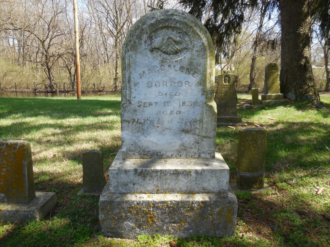
Borrors Corners – Jackson Township
Post Office: 1894 – 1900
Location: 39.825405, -83.032575
on SR 665 (London – Groveport Rd) at the intersection of SR 104 (Jackson Pike) along Plum Run
Remnants: historical marker on the southeast side of the intersection, Scioto Cemetery on the south side of Hiner Rd off of SR 104, many old houses and farm buildings in the area
Description: Magdalene (Strader) Borror (1767 – 1838) from Virginia was the widow of Revolutionary War veteran Jacob Borror Jr. (1763 – 1804). She moved to Ohio with her 7 children and settled on 400 acres of land surrounding the GPS coordinates given to her by her parents in 1809 – 1811. The family became successful in farming and merchandising and was very influential in Jackson Township for over 100 years. Borrors Corners had a grocery store in the northwest corner of the intersection and a blacksmith shop in the northeast corner of the intersection. The first school was on the east side of SR 104 in the mid-1800s. It was replaced with a newer school across the road prior to publication of the 1872 county atlas. There was a Union church near Scioto Cemetery on the west side of SR 104 just south of Hiner Rd. That church was gone by publication of the 1872 county atlas which pinpointed Scioto Christian Church about halfway between Hiner Rd and the new school. Magdalene was laid to rest with many relatives in Scioto Cemetery. The cemetery wasn’t officially established until 1886, but its burials go back much further. For a small cemetery, it features an astonishing amount of large and ornate gravestones and memorials for the Borrors. It goes to show how prominent they were and the impact they made on the area. More of the family’s ancestors and descendants can be found in Concord Cemetery on Hoover Rd south of SR 665, Grove City Cemetery, and Green Lawn Cemetery in Columbus.
Bright – Madison Township
Location: 39.865341, -82.922123
on Groveport Rd at the intersection of Bixby Rd
Remnants: none known
Description: This small village had a school on the south side of Groveport Rd southeast of the intersection. Much of the land around the GPS coordinates was owned by the Kile family.
Burts
Location: unknown
Description: It was named after the Burt family in the county.
Caldwell
Location: unknown
Description: It was named after a branch of the Caldwell family in the county.
Clover Settlement – Prairie and Brown Township
Location: 39.962555, -83.168382
on Alton Darby Creek Rd between I – 70 and US 40
Remnants: Clover Cemetery at the GPS coordinates
Description: Henry and Catherine Clover moved to Ohio from Virginia with their 12 children and originally lived in Ross County. They relocated to Prairie Township in 1813 and Clover Settlement formed around their property with more families moving to the area in the early 1800s. Across from the cemetery on the east side of Alton Darby Creek Rd, the town had a school, Methodist church, and a general store and train station on the north side of the railroad tracks. Clover Settlement faded away in the later 1800s as Alton to the south was expanding and had more modern accommodations. Alton’s train station on the south side of the Pennsylvania Railroad tracks replaced Clover’s station and can be found in the 1872 county atlas. Most of the Clover family was buried in Clover Cemetery and some relatives and descendants were buried in Alton Cemetery between the railroad tracks and US 40.
Deems – Franklin Township
Location: 39.970104, -83.115745
on Fisher Rd between I – 270 and Philip Rd
Remnants: none known
Description: The town was founded by Thomas Deems (1807 – 1880) from Pennsylvania and Mary (Sims) Deems (1807 – 1880) from Muskingum County. They married in 1828, had 6 children, and moved to Franklin County in 1841. Thomas was a farmer and blacksmith. The Deems were buried with relatives in Green Lawn Cemetery.
Doneys – Truro Township
Location: 39.956283, -82.904633
on US 40 at the former railroad crossing between James Rd and Beechwood Rd
Remnants: none known
Description: Abraham Doney (1829 – 1900) from Harrison County and Emily Brock (1837 – 1899) from Fairfield County moved to Truro Township in 1865 and had 6 children. They were farmers and livestock dealers and amassed 600 acres of land between US 40 and E Broad St (SR 16). The town had a train station on the Columbus, Sandusky, & Hocking Railroad. Abraham and Emily were buried with relatives in Green Lawn Cemetery.
Eastwood – City of Columbus (formerly in Montgomery Township)
Location: 39.967843, -82.957473
on Eastwood Ave at the intersection of Woodland Ave
Remnants: Eastwood Ave
Description: The town was first spotted on the 1856 county map and never had much of a chance at keeping its own identity. It had a school and Congregational church, but was too close to downtown Columbus and was annexed by the 1870s. Eastwood Avenue itself is a remnant of the former town. Its narrow construction is reminiscent of average roads in the mid-1800s.
Flint Station – Sharon Township
Post Office: 1868 – 1912
Location: 40.127303, -83.005196
on Park Rd at the railroad crossing between Flint Rd and Sancus Blvd
Remnants: The Market at Flint Station at the GPS coordinates, Flint Cemetery on Flint Rd
Description: Although the town of Flint is still a populated area, Flint Station is considered to be a ghost town and is on the state’s historical populated places list. The town had stations on the Big Four Railroad (Cleveland, Cincinnati, Chicago, & St. Louis Railroad) and the Sandusky & Columbus Short Line Railroad. Many early residents were buried in Flint Cemetery on the west side of Flint Rd. The Market at Flint Station is a lounge and the building that houses it was constructed in 1890.
Hibernia – Truro Township
Post Office: 1849 – 1857
Location: 39.954753, -82.851364
on US 40 at the intersection of Noe Bixby Rd along Big Walnut Creek
Remnants: Carlisle Cemetery at Hibernia Apartments on Hibernia Dr south of US 40 off of Noe Bixby Rd
Description: Irish immigrant Thomas Armstrong (1769 – 1856) sold some lots which founded Hibernia in the 1840s. The town was never platted or incorporated but had a school, hotel, grocery store, wagon shop, and blacksmith shop. Thomas was buried with relatives in Carlisle Cemetery. It predates the town by a few decades.
Highway – Norwich Township
Location: unknown
Description: Highway was on the Toledo & Ohio Central Railroad between Columbus and Hilliard’s northern side.
Hocking Junction
Location: unknown
Description: none found
Lafayetteville – Plain Township
Location: 40.080156, -82.789975
on E Dublin Granville Rd at the intersection of Kitzmiller Rd
Remnants: none known
Description: There were two attempts to lay out a town called Lafayetteville in Franklin County. The first was made in 1826 by Lorin Hills and Lester Humphrey. The platted lots either never sold or didn’t sell enough to make any difference in the area.
Lafayetteville – Prairie Township
Location: 39.942576, -83.143756
the exact location of the plat is unknown
Remnants: Postle Cemetery at the GPS Coordinates west of Norton Rd and north of Gabriels Landing Dr
Description: In 1832 War of 1812 veteran Job Postle (1781 – 1858) and Elizabeth (Webb) Postle (1780 – 1850) platted another town called Lafayetteville with the same results as the first. Job and Elizabeth were buried with relatives in Postle Cemetery.
Lisle – City of Columbus (formerly in Clinton Township)
Location: 40.004814, -83.034240
on Kenny Rd between W Lane Ave and Kinnear Rd and stretching east to the Olentangy River
Remnants: none known
Description: Part of The Ohio State University campus is the site of a ghost town. John Lisle and Rachel (Irwin) Lisle moved to Ohio from Kentucky in 1798 and settled in Clinton Township a couple of years later. They had 8 children in total and a large farm. The town also had a school on the east side of Kenny Rd north of the GPS coordinates. John and Rachel were buried with relatives in Union Cemetery on Olentangy River Rd.
Marble Cliff Mills – City of Columbus (formerly in Perry Township)
Post Office: 1874 – 1915
Location: 39.984891, -83.065140
on US 33 at the intersection of Cardigan Ave along the Scioto River
Remnants: none known
Description: Thomas Backus (1785 – 1825) and Tempera (Lord) Backus (1786 – 1864) made the journey to Ohio from Connecticut and mills next to the Scioto River in 1812 – 1813. They had 5 children and later moved to Marion County where Thomas served as a prosecuting attorney. The mills were sold a few times and were called Marble Cliff by the 1850s. The town also had stone and slate quarries, a general store, boot and shoe shop, Methodist Church, and a train station on the Pittsburgh, Cincinnati, & St. Louis Railroad. Although the mills themselves are long gone, Marble Cliff became a town in 1890 and was incorporated in 1901. Thomas and Tempera were buried with many relatives in Woodlawn Cemetery on Central Ave in Toledo, Lucas County.
Marburn – Clinton Township
Location: 40.043621, -83.038212
on Ruby Rd at the intersection of Overlook Dr
Remnants: former school north of the GPS coordinates on the west side of Ruby Rd
Description: It’s unclear when Marburn was considered to be a town and when it fell off of maps, but it was likely sometime in the mid to late 1900s as there’s no mention of the place in the old history books. Marburn School opened in 1960 and closed in 1977. A subdivision named Marburn sits south of the school.
Millers – Pleasant Township
Location: 39.824834, -83.141150
on US 62 at the I – 71 Underpass
Remnants: none known
Description: This small farming town was along the B&O Railroad and was founded by Charles C. Miller (1854 – 1939) who owned 185 acres of land in the vicinity. He was buried with relatives in Grove City Cemetery.
Mosel
Location: unknown
Description: It was founded by a branch of the Mosel family in the county.
Mount Pleasant – City of Columbus (formerly in Montgomery Township)
Location: 39.983827, -83.003535
on Mt Pleasant Ave at the intersection of E 3rd Ave
Remnants: none known
Description: Francis Clymer (1798 – 1878) from Maryland and Susannah (Harris) Clymer from Ohio platted Mount Pleasant on their farm in 1835, but the town never grew any and was quickly abandoned. The area was subsequently annexed into Columbus. Francis and Susannah had 6 children and moved to Hancock County, becoming some of the earliest pioneering settlers there. Francis and Susannah were buried with relatives in Clymer Cemetery next to Pleasant View Church on Co Rd 37 in Union Township, Hancock County.
Oregon – Madison Township
Post Office: 1829 – 1834
Location: 39.822586, -82.832657
on Lithopolis Rd at the intersection of Oregon Rd
Remnants: Middletown Cemetery on private property east of Gender Rd
Description: Oregon was originally called Middletown. It was platted by Issac Decker in 1817 but never grew much. The town name changed between 1830 and 1831. Issac and his wife, name unknown as of yet, operated a tavern at their cabin for 30 years and worked together in the shoemaker trade. The shoe services were offered in exchange for getting some of their farmland cleared for crops and livestock. They were buried with relatives in Decker Cemetery. It was stated in the 1880 History of Franklin and Pickaway Counties, Ohio that Oregon was “now almost vanished” and it didn’t make it onto the 1883 Franklin County map.
Portersburg (Pin Hook) – City of Columbus (formerly in Blendon Township)
Location: 40.085628, -82.895440
on Sunbury Rd at the intersection of Valley Quail Blvd S along Big Walnut Creek
Remnants: none known
Descripton: W. H. Porter and Eve Porter (1774 – 1840) arrived in the area in the early 1800s and the town was named after their family. Joseph Dickey (1796 – 1845) and Lovina (Taggart) Dickey (1801 – 1854) moved to the town from Washington County, New York in 1838. Joseph was a blacksmith and his shop turned into a meeting places for local discussions on politics and religion, as well as less pressing matters. Portersburg also had a school and saw mill. The town name later changed Pin Hook and can be found by that name in the 1872 county atlas, but it wasn’t listed on the 1883 map. Many members of the Porter and Dickey families were buried in Blendon Central Cemetery on the north side of Dempsey Rd.
Renner – Norwich Township
Location: 39.982876, -83.165112
on Renner Rd at the intersection of Spindler Rd
Remnants: Saint James Lutheran Church and Cemetery at the intersection of Renner Rd and Hilliard Rome Rd
Description: The town was founded by German immigrants Johann Renner (1802 – 1882) and Anna Renner (1804 – 1878) who had a 230-acre farm and several children. Saint James Lutheran Church congregation began in 1847. Foundation stones from the original log building are on the northwest corner of the cemetery. The current structure was built in 1872. There was also a school next to the church. Johann and Anna were buried with relatives and other German pioneers from the area in the cemetery. The older headstones were inscribed in German. That was the dominant language for the church until the 1890s when many of the early settlers grandchildren only spoke English.
Ridpath – Jackson Township
Post Office: 1892 – 1901
Location: 39.826735, -83.089813
on Zuber Rd at the intersection of Ridpath Rd
Remnants: old houses and farm buildings in the area
Description: Farming was Ridpath’s main industry. It had a school, wagon shop, and a tile works in the 1870s. The town was never platted or incorporated.
Scioto – Norwich Township
Location: 39.994794, -83.085962
Remnants: none known
on Traube Rd at the intersection of McKinley Ave
Description: Scioto Station was on the Big Four Railroad. A modern housing complex bearing the same name is on the east side of McKinley Ave south of the GPS coordinates.
Sharp – Hamilton Township
Location: 39.854529, -82.953468
on Reese Rd at the intersection of Bixby Rd
Remnants: none known
Description: none found
Shattucksburg – City of Columbus (formerly in Perry Township)
Location: 40.053078, -83.049639
on Kenny Rd at the intersection of Henderson Rd
Remnants: none known
Description: Simon Shattuck (1793 – 1875) from Massachusetts operated a general store in the southwest corner of the intersection and sold some lots on his farm for improvement around 1850. About half a dozen families moved to the area and took up residence there. The town was listed on the 1856 county map but didn’t make it into the 1872 county atlas.
Slate Run
Post Office: 1838 – 1844
Location: unknown
Description: The post office was along Slate Run on the west side of Columbus.
Smileys Corners – Norwich Township
Post Office: 1852 – 1855
Location: 40.016630, -83.099242
on Dublin Rd along Millikim Creek at the bend between the railroad tracks and Smiley Rd
Remnants: Wesley Chapel and Cemetery north of the GPS coordinates
Description: The town was founded by David Smiley (1786 – 1861) and Elizabeth (Latimer) Smiley (1791 – 1849). David was a justice of the peace and a farmer. The Smileys ran a general store, hotel, the post office, and had a few children. There was also a school just west of the GPS coordinates. David and Elizabeth were buried with relatives in Wesley Chapel Cemetery. Their son David married Sarah Deems, a daughter of Thomas and Mary Deems. The present structure of Wesley Chapel was built in 1891.
Sullivants – Franklin Township
Location: 39.942476, -83.098340
on Sullivant Ave at the intersection of Ruffing Ln
Remnants: none known
Description: Michael Sullivant (1807 – 1879) was a son of the founders of Columbus (Franklinton) Lucas Sullivant (1765 – 1823) and Sarah (Starling) Sullivant (1781 – 1814). In the mid-1800s Michael platted much of what would later become the west side of Columbus. He was buried with relatives in Green Lawn Cemetery.
Waldeck – City of Columbus (formerly in Clinton Township)
Location: 40.007111, -83.005183
on E Norwich Ave at the intersection of Waldeck Ave
Remnants: none known
Description: Waldeck only appeared on the 1856 county map and the origin of its name is unknown.
Wheatland – City of Columbus (formerly in Franklin Township)
Post Office: 1858 – 1860
Location: 39.955545, -83.061823
on US 40 at the intersection of Wheatland Ave
Description: Prior to the arrival of the Central Ohio Lunatic (Insane) Asylum, wheat was grown in a great abundance on the west side of Columbus. Since the hospital facility was demolished in the 1990s, the Wheatland Farm organization at 116 N Wheatland Ave has been working on turning a portion of the former asylum back into viable crop land.
Whittington
Location: unknown
Description: none found
Wildwood Springs – City of Columbus (formerly in Mifflin Township)
Location: 40.079364, -82.916543
on Harvestwood Ln off of Strawberry Farm Blvd along Alum Creek
Remnants: none known
Description: The town was named after a natural water spring near Alum Creek. It was on land owned by Daniel Turney (1772 – 1856) and Susannah (Ridenour) Turney (1783 – 1857). They were buried with relatives in Riverside Cemetery south of town on the east side of Sunbury Rd.
Wonderland – City of Columbus (formerly in Jefferson Township and Mifflin Township)
Post Office: 1955 – 1974
Location: 40.002938, -82.870663
on Thruway Dr at the intersection of Jansen Ave on the east side of Big Walnut Creek
Remnants: Wonderland Community Church and former roads
Description: Wonderland was founded in the 1920s as a summer resort community. It was much like what was seen in Dirty Dancing with the exception of having a lake. Some of the houses were winterized and lived in year round. The property was sold to Port Columbus International Airport in the 1980s and the remaining residents were forced out. Wonderland Community Church was built in 1941 and was saved by its congregation.
Zuber – Jackson Township
Post Office: 1894 – 1900
Location: 39.825413, -83.032583
on SR 665 (London Groveport Rd) at the intersection of SR 104 (Jackson Pike) along Plum Run
Remnants: none known
Description: Zuber was the name of the post office at Borrors Corners as its original town name was fading away.