

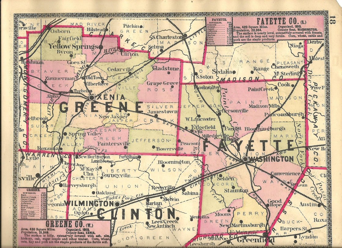
Featuring 2 towns with 5 pictures from Fayette County, Restored Ohio was released on April 29, 2019. It’s the sequel of Abandoned Ohio (2018) and shows a different side of what physically remains of Ohio’s past. Many of the locations operate as businesses such as restaurants, hotels (former stagecoach stops), museums, and working mills.
Ordering Links
Arcadia Publishing – https://www.arcadiapublishing.com/Products/9781634991216
Amazon – https://www.amazon.com/Glenn-Morris/e/B07G8N3HP2/ref=ntt_dp_epwbk_0
Barnes & Noble – https://www.barnesandnoble.com/w/restored-ohio-glenn-morris/1129901378?ean=9781634991216
Walmart – https://www.walmart.com/ip/Restored-Ohio/185272799
Target – https://www.target.com/p/restored-ohio-by-glenn-morris-paperback/-/A-78016964
Convenience – Wayne Township
Post Office: 1840 – 1902
Location: 39.500137, -83.360149
on US 35 at the intersection of Camp Grove Rd
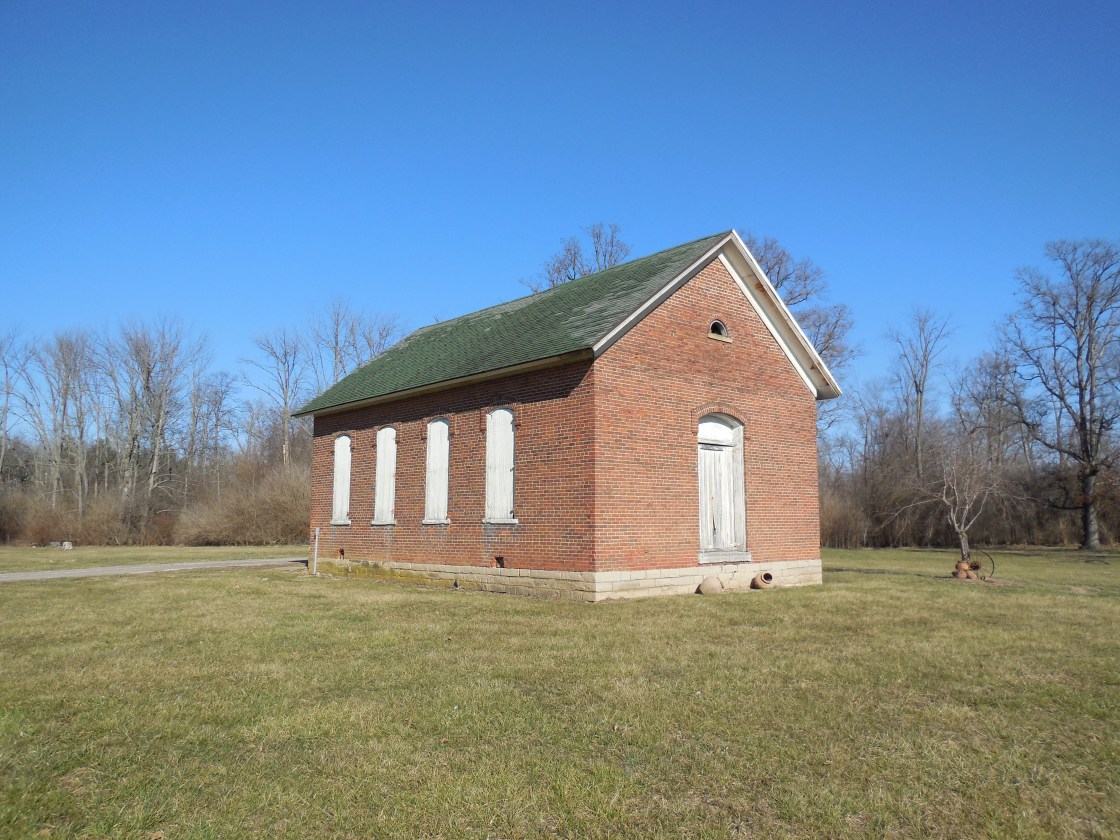
Remnants: former one-room schoolhouse in the northwest corner of the intersection
Description: Convenience was on the Toledo, Delphos, & Burlington Railroad (later the Cincinnati, Hamilton, & Dayton Railroad). Its original proprietors were Noah Hukill (1805 – 1887) from Ohio County, West Virginia (formerly in Virginia) and Susan (Smith) Hukill (1801 – 1877) from Pittsburgh, Pennsylvania. They got married in Fayette County in 1831, had 5 children, and ran a stagecoach stop tavern and inn prior to the arrival of the railroad in the area. The school land was donated by War of 1812 veteran James Bryant (1787 – 1848) from Virginia and Catharine (Eyeman) Bryant (1792 – 1869) around 1844. German Baptist church services were held in the school until a wood frame church was constructed in the southwest corner of the intersection in 1853 – 1854. The church has since been lost to time, but the town’s last one-room schoolhouse in the northwest corner of the intersection appears to be in decent preserved condition for its age. A son of Noah and Susan, William R. Hukill (1834 – 1904) and his wife Mary (Kelso) Hukill 1836 – 1909), took on proprietorship of the town in the mid to late 1800s. They got married in 1858 and had 3 children. War of 1812 veteran and county pioneer John H. DeWitt (1785 – 1855) from Clark County, Kentucky was the first postmaster. William was appointed to the postmaster position after John passed away. He also served as justice of the peace and the train station attendant. The post office was discontinued from the late 1860s to mid-1880s, and William again held the postmaster position until the office was discontinued. The train tracks ran through the northern side of town and its former bed is now part of the Paint Creek Recreational Trail, a 35-mile paved path running from Washington Court House to Chillicothe in Ross County. The Hukills were buried in Washington Cemetery about 5 1/2 miles northwest of the GPS coordinates on US 22 in Washington Court House. James Bryant was laid to rest in Bryant – Eyeman Cemetery on private property 2 miles southeast of the GPS coordinates on the east side of Boyd Rd SE (Co Hwy 149) along Mills Branch. Catharine Bryant moved out of state with some of their children and was buried with relatives in Rice Cemetery on the western end of 40th St in Morning Sun, Iowa. Descendants of the family still live on the old homestead farm there. John Dewitt was buried with relatives in DeWitt Cemetery about 1 1/4 miles northwest of the GPS coordinates on private property on the north side of the Paint Creek Recreational Trail.
Ghormley (Ghormley’s Station) – Wayne and Perry Township
Location: 39.409472, -83.378715
on Ghormley Rd along Paint Creek between SR 41 (Highland Ave) and SR 753
Remnants: abandoned and old houses and farm buildings in the area
Description: Thomas Ghormley (1766 – 1840) and Judith (Bonner) Ghormley (1770 – 1839) were both born in Pennsylvania and had 10 children. They moved to Ohio in 1813 and settled on a 500-acre farm at the GPS coordinates the following year. Thomas and Judith passed away on the farm and one of their sons, William L. Ghormley (1808 – 1886), acquired 113 acres of the family homestead. He married Hannah (Beatty) Ghormley (1808 – 1898) in 1837 and had 5 children. The town had a flag stop on the Ohio Southern Railroad and a school (Wayne Township No. 1) on the south side of Ghormley Rd about 1/2 of a mile east of the GPS coordinates. The next couple generations of the Ghormley family continued proprietorship of the old farm and town. A train station was pinpointed at the GPS coordinates in the 1913 county atlas on what was then the Detroit, Toledo, & Ironton Railroad. The former railroad tracks are long gone, but the path can still be seen on satellite maps. William and Hannah were laid to rest with relatives in Greenfield Cemetery 5 miles south of the GPS coordinates on SR 753 (N Washington St) in Greenfield, Highland County. Thomas and Judith were buried with relatives in Old Burying Ground about 1 mile southeast of Greenfield Cemetery at the intersection of SR 138 and S McArthur Way in Greenfield.
Kingfred (Kingford Siding) – Union Township
Location: 39.544713, -83.346130
on Camp Grove Rd SE at the former railroad track crossing just south of US 22
Remnants: none known
Description: The town was originally called Kingfred and was on the Cincinnati & Muskingum Valley Railroad in the late 1800s to early 1900s. It changed to Kingford Siding when a passenger siding was built for loading and unloading between the tracks of the Penn Lines, an interurban electric rail car route which operated on the former track bed of the Cincinnati & Muskingum Valley Railroad. The main function of interurban cars was transporting workers from rural and suburban areas into cities during the times before automobiles were affordable for the average consumer. A school (Union Township No. 16) was on the south side of US 22 about a mile west of the GPS coordinates.
Olympia – Union Township
Location: 39.541274, -83.377513
on Bogus Rd SE at the former railroad crossing just south of US 22
Remnants: none known
Description: Olympia was also on the Penn Lines interurban route in the early 1900s. A school (Union Township No. 16) was on the south side of US 22 about halfway between Olympia and Kingfred (Kingford Siding).
Pearsons (Pearson Station) – Jasper Township, Fayette County and Jefferson Township, Greene County
Post Office: 1877 – 1903
Location: 39.593950, -83.660200
on Marchant – Luttrell Rd between Pearson – Octa Rd and Hargrave Rd along Grassy Branch
Remnants: none known
Description: The town was founded by the Pearson family in the area and had a train station on the Dayton, Toledo, & Ironton Railroad. Chaney E. Pearson (1838 – 1927) was the first known postmaster. He married Mary (Plymire) Pearson (1845 – 1917) in 1861 and had a few children. The other known postmasters were James L. Rowe, C. P. Luttrell, Henry G. Kiger, and Allen B. Pearson (1876 – 1914) held the position until the office was discontinued. Allen married Sudia (Carter) Pearson (1880 – 1937) in 1897. in Pearson’s population was 38 residents 1910. It was listed in the 1913 county atlas and fell into obscurity by the mid-1900s. Chaney and Mary were buried with relatives in Old Silvercreek (Jamestown) Cemetery about 6 3/4 miles northwest of the GPS coordinates on SR 72 in Jamestown in Silvercreek Township, Greene County. Allen and Sudia were laid to rest with an infant son who passed away in 1911 in Sabina Cemetery 9 miles south of the GPS coordinates on Polk Ave in Sabina, Clinton County. The Pearson and Luttrell families were related by marriage. Luttrell is still a currently populated place 1 mile southeast of the GPS coordinates in Jasper Township.
Hagler, OH – (1814 – present farming town with less residents than in the past)
Classification: small town
Location: Jefferson Township, Fayette County – On Old US Hwy 35 near the intersection of Harmony Rd
Hagler is an unincorporated village. It was first settled by War of 1812 veteran Captain Isaac Hagler (1792 – 1830) and Susannah (Stookey) Hagler (1793 – 1887). They were farmers and had 9 children. Their son Jesse took over the family farm after his father’s untimely death and went on to own over 1,000 acres of land. Farming, and cattle and horse ranching were the main sources of income. Hagler had a post office located on Township Hwy 87 (Inskeep Rd) from 1886 – 1906 and a train station on the the Detroit, Toledo & Ironton Railroad. The Hagler family cemetery is in a field on private property near US Highway 35. There are newer residences in the area and no known remnants of the original town aside from the cemetery.
Staunton, OH – (1848 – present farming town with little growth)
Classification: small town
Location: Concord Township, Fayette County – On US 62 at the intersection of Vine St
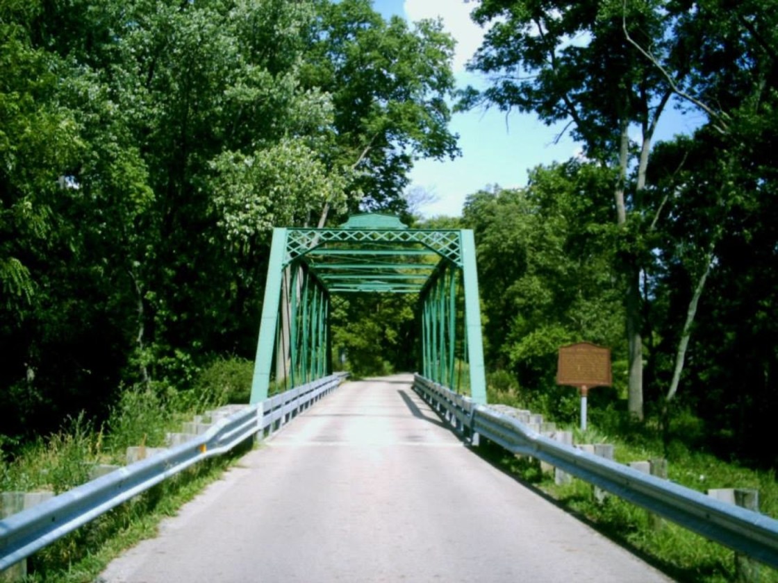
Immediately behind buildings, bridges are our second favorite type of historical landmarks. On top of their wide range of architecture, their useful necessity keeps many old bridges intact and attracts restoration efforts. Mark Road Bridge crossing Sugar Creek off of US Route 62 in Staunton is a perfect example. It was constructed in 1883 and restored in 2007. The Mark family was the largest in the area and the road and bridge were aptly named after them. Half of the family lived in Jasper Mills in Jasper Township and the other half in Staunton, the only town in Concord Township.
The town was named by settlers from Staunton, Virginia. Michael Mark opened a blacksmith shop in the area in 1835. It was followed by a general store owned by Thomas Craig in 1842 and a post office in 1844. The town was platted in 1848. Residents had big hopes of getting a railroad someday but that never happened. As a result, the town’s peak population of around 100 citizens hasn’t changed much over time. Mark Family Cemetery is on the east side of Staunton Jasper Rd and more members were buried in Staunton Methodist Church Cemetery on US 62 in town.
Yankeetown, OH – (1810s – present farming town with little to no growth)
Classification: small town
Location: Madison Township, Fayette County – On SR 207 at the intersection of Cook – Yankeetown Rd
It was settled in the 1810s by several different families, mostly from the New England States, hence the name Yankeetown. It was never platted or incorporated and didn’t have a post office. The closest railroad was 5 miles north in Mt. Sterling, which had a train station on the B&O Railroad.
The first store was built in Yankeetown in 1815, followed by a church and blacksmith shop in 1823. Many other small businesses operated over the years, but the town didn’t have a lot of them at any given time, so the population always remained stagnant at around 100 or less. Yankeetown Cemetery is in a field down a short gravel road off of Cook – Yankeetown Rd, about 3/4 of a mile southeast of SR 207.
Fayette County, Ohio Ghost Towns Research Resources
1875 – Fayette County atlas
1913 – Fayette County atlas
1881 – History of Fayette County
1892 – Portrait and Biographical Record of Fayette, Pickaway, and Madison Counties, Ohio
1914 – History Of Fayette County, Ohio
