
Buckeye Park – Greenfield Township
Location: 39.772180, -82.686534
on Old Columbus Rd NW at the intersection of Coonpath Rd NW
Remnants: none known
Description: Prior to the establishment of the park, Methodist camp meetings were held on the farm of John W. Mason (1836 – 1903) and Elizabeth (Flick) Mason (1840 – 1887) in the mid-1870s. A church was subsequently built there in the northeast lot of the intersection. John & Elizabeth were laid to rest with relatives in Violet (Violet Township) Cemetery 9 3/4 miles northwest of the GPS coordinates on the north side of SR 256 (E Columbus St) in Pickerington. A school (Greenfield Township No. 4) was on the south side of Coonpath Rd NW 1/2 of a mile west of the GPS coordinates. Buckeye Park was developed in the 1890s by the managers of the Columbus, Hocking Valley, & Toledo Railroad and was also along the Hocking Canal. The canal endured a series of devastating floods in the late 1800s and had already been rendered obsolete by railroads. It officially closed in 1890. The park was just south of Coonpath Rd NW and was designed as a destination to increase train use on the weekends. It had a small lake for boating and swimming, a giant slide still commonly seen at amusement parks these days, a playground, and some recreational buildings. A train station was built to accommodate the visitors and was very much appreciated by local residents who previously had to wait at a shelterless flag stop. After a failed first attempt in 1895 on the Cleveland Canton, & Southern Railroad in Stark County, A. L. Streeter from Illinois organized the first steam train collision for entertainment at Buckeye Park on Memorial Day May 30, 1896. An estimated 20,000 – 25,000 onlookers from all across the country witnessed the collision. It was the beginning of nearly 40 years of similar instances, with A. L. Streeter and other copycat promoters doing the same up through the 1930s. Buckeye Park’s name changed to Maplewood Park after Buckeye Lake, originally the Licking Summit Reservoir, was created and had a park there. A baseball team called the Maplewoods formed in 1906. The park was upgraded with a dance pavilion and bowling alley. In the mid-1910s the Bismark Club of Columbus purchased the park. They constructe an arched gateway, improved the roads, installed paved walking paths, and cleared up overgrowing brush. The name changed again to Columbia Park during World War I. It continuted as Columbia Park until 1943 when the Lancaster Moose Lodge bought the grounds and renamed it Moose Park. They modernized it to mid-1900s standards, upgraded existed amusements, and added more. The park was sold in 1955 to the Woltz and Stephens families from Columbus who did some remodeling and reopened it under the name of Maple Park as a recreational center. Kelly R. Hannan bought the park in 1959, changing the name to Hannan Recreation Center. During that time, the park was mostly used by local organizations for meetings and events. A tornado swept through the area on April 12, 1965 and destroyed much of the park. Hannan sold the park and it yet again changed names to Long Lake Park in the early 1970s. By then, most of the old large amusements were gone and it was more of a retreat focused on activities and camping. It turned into Camp Coonpath when Al Moore purchased the property in 1988. The 110-year history ended in 2001 when the state acquired the property for construction of the present US 33 bypass.
Claypool (Yankeetown) – Greenfield Township
Location: 39.759052, -82.669743
on Columbus – Lancaster Rd NW at the intersection of Claypool St NW
Remnants: Greenfield Township Cemetery on the east side of Columbus – Lancaster Rd NW just south of the GPS coordinates
Description: The town was along the Hocking Canal and was founded by Jacob Claypool Sr. (1775 – 1843) from Bedford County, Virginia and Margaret (Baker) Claypool (1779 – 1828) from Rockingham County, Virginia. They purchased a large farm at the GPS coordinates in 1805 at a site that had previously been dubbed as Yankeetown as early as 1799. Jacob cleared the land, planted some crops, and built a log cabin there before moving his family to the homestead in 1808. He learned how to survey land and served as a representative in the state legislature in 1816, 1818, and 1822, and a senator from 1823 – 1824. Jacob had at least 6 children with Margaret and married Ann (Renick) Claypool (1789 – 1834) after she passed away. The Claypools donated land for a church and school around 1830 which later turned into Greenfield Academy. The cemetery was also established on the their farm. Issac Claypool (1821 – 1902) attended the Greenfield Academy and inherited the family farm. He donated a bit of land in its southwest corner for the track bed of the Columbus & Hocking Valley Railroad (later the Columbus, Hocking Valley, & Toledo Railroad). Issac expanded the farm to 571 acres by publication of the 1889 county map and lived his entire life on the family homestead. With much success in farming and livestock raising, Issac accumulated a total of 1,200 acres in Green Township. He was married 3 times and had at least 9 children. Everyone mentioned in this listing was laid to rest in Greenfield Township Cemetery.
Harrisport – Greenfield Township
Location: unknown
Description: Harrisport contained 12 – 15 residences and was listed in The Ohio Gazetteer and Traveler’s Guide from 1837 – 1841. Its last literary mention was in the 1843 A History and New Gazetteer: Or Geographical Dictionary, of North America and the West Indies. The town faded out of existence and didn’t make it onto the 1848 county map.
Millers – Clearcreek Township
Location: 39.587453, -82.785347
on Heigle Rd SW at the intersection of 16th Rd SW east of the confluence of Wolf Creek and Salt Creek
Remnants: Wolf Cemetery 1 1/4 miles west of the GPS coordinates in a field on private property on the north side of Heigle Rd SW, old houses and farm buildings in the area
Description: This small farming town was listed on the Ohio map in the 1901 George Cram atlas and was on the Lancaster & Hamden Railroad. Prior to the railroad’s arrival, the Wolf (Wolfe) and Hoffman (Huffman) families were the largest in the area. Wolf Cemetery was established on a large farm owned by War of 1812 veteran Peter Wolfe (1787 – 1853) from Pennsylvania and has interments dating up to the first decade of the 1900s. Some residents attended Fairview United Methodist Church and a one-room schoolhouse (Clearcreek Township No. 5), both of which still stand a mile north of the GPS coordinates in the northwest corner of the intersection of 16th Rd SW and Oakland – Soutsville Rd SW.
Monticello – Walnut Township
Post Office: 1827 – 1833
Location: 39.899844, -82.562552
on SR 37 (Lancaster – Newark Rd NE) at the intersection of SR 204 (Blacklick – Eastern Rd NE)
Remnants: none known
Description: The short lived town of Monticello was listed in The Ohio Gazetteer, Or, Topographical Dictionary from 1829 – 1833. It formed around 1825 and was a busy village for a few years, but it lost the competition for businesses and residents to nearby Millersport which was also platted in 1825 along the Ohio & Erie Canal. Bennett Lewis was the first known postmaster. He was succeeded by Wilson J. Lewis (1804 – 1890) from Pennsylvania who held the office until it was discontinued. Wilson married Mary Ann (Dailey) Lewis (1814 – 1868) in Fairfield County in 1830. They moved out of Fairfield County with relatives in Greenlawn Cemetery at the intersection of E County Rd 36 (Cr36) and Cr13 in Tiffin, Seneca County.
Roby Addition – Liberty and Walnut Township
Location: 39.922686, -82.582278
on Blacklick Rd NW at the intersection of Cherry Ln on the Liberty and Walnut Township border
Remnants: Fletcher Chapel and Cemetery on the north side of Blacklick Rd NW 1/2 of a mile west of the intersection
Description: Benjamin Roby (1801 – 1886) moved to Ohio from Virginia and platted the Roby Addition on a 60-acre farm in the northwest corner of the intersection. It’s unknown exactly when the plat was made, but in any case, it failed to attract residents and the idea was eventually abandoned. Benjamin married Ursula (Morton) Roby (1803 – 1840) in Fairfield County in 1829. After Ursula passed away, he married Sarah (Siebert) Roby (1819 – 1905) from Pennsylvania in 1846. A school (Walnut Township. No 4) was in the northeast corner of the intersection on a 253-acre farm owned by James H. Jeffries (1811 – 1887) and Mary (Benadum) Jeffries (1815 – 1898) from Farquier County, Virginia. The congregation of Fletcher Chapel United Methodist Church was organized around 1815. They met in private residences until a log church was built in the mid-1820s. It was replaced with a wood frame structure in 1846 and much later the present brick building. Everyone mentioned in this listing was laid to rest with relatives in Fletcher Chapel Cemetery.
Sandstone – City of Lancaster
Location: 39.714527, -82.543528
on Quarry Rd SE at the railroad crossing between US 22 and Commerce St
Remnants: none known
Description: Sandstone was named after a quarry in the area and was on the Cleveland & Mahoning Valley Railroad. It was listed on the Ohio map in the 1901 George Cram atlas.
Steele (Steeles) – Clearcreek Township
Location: 39.572225, -82.783688
on 16 Rd SW along Salt Creek between Heigle Rd SW and Thomas Hill Rd SW
Remnants: none known
Description: Steele was listed on the Ohio map in the 1901 George Cram atlas and was on the Lancaster & Hamden Railroad in the late 1800s to early 1900s. It has a school (Clearcreek Township No. 8) on the west side of Salt Creek just west of the GPS coordinates on land owned by the Thomas family.
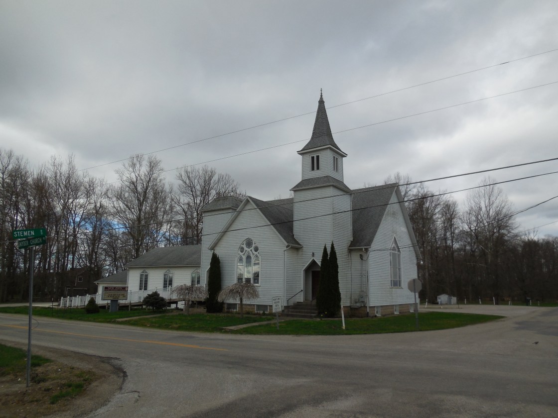
Sniders (Snyders) – Liberty Township
Location: 39.887768, -82.641918
on Snyder Church Rd NW at the intersection of Stemen Rd
Remnants: New Zion United Methodist Church at the intersection, Union Evangelical (New Zion / Snider) Cemetery on both sides of Snyder Church Rd NW about 1/3 of a mile south of the GPS coordinates, former one-room schoolhouse 1 1/2 miles southeast of the GPS coordinates on Bickel Church Rd NW, St. Michael’s United Church Of Christ next to the school, Saint Michaels Cemetery across the road
Description: The town was founded by Swiss immigrant Jacob Snider (1815 – 1894) and Phebe (Brumbach) Snider (1820 – 1886). Phebe’s paternal grandfather, Johann Brumbach, was a German immigrant and Revolutionary War veteran. He passed away in Virginia. The Snider family owned most of the land surrounding the GPS coordinates in the mid to late 1800s, with Jacob and Phebe’s farms totaling over 700 acres at one point. They were buried with many relatives and descendants in Union Evangelical Cemetery. The former one-room schoolhouse (Liberty Township No. 8) next to St. Michael’s United Church of Christ appears to be in excellent preserved condition. The church was formerly across the road with a wood frame structure at the cemetery and was later replaced with the present brick church. New Zion United Methodist Church was originally in the opposite corner of the intersection. Its impressive wood frame building was constructed in 1897. There were also several other churches and one-room schoolhouses on the outskirts of town throughout the mid to late 1800s. St. Michael’s Church was built in 1875 and its accompanying cemetery was officially established in 1914.
Tarhe Town – City of Lancaster
Location: 39.707898, -82.599538
on S Water St between Locust St and the Hocking River
Remnants: none known
Description: This Wyandotte Native American village was named after Chief Tarhe (1742 – 1818) who lived there at various times. He earned the title in 1788, was one of 13 Native American chiefs who fought at the Battle Of Fallen Timbers in 1794, and was the only one who survived. He was also one of the signers of the Treaty Of Greenville in 1795. Chief Tarhe’s nickname was “The Crane”, for his slender build and being 6 feet 4 inches tall. He was buried in Upper Sandusky in Wyandot County. A monument was dedicated to him there in 1915 at the site of Cranetown on T-37 (Co Hwy 37) north of SR 67 (Tarhe Trail).
Walnut (Hitedale) (Bush’s Corners) (Bush City) (Hadley Junction) (Thurston) – Walnut Township
Post Office: 1826 – 1832, 1858 – 1867, and 1881 – present
Location: 39.840275 -82.549460
on SR 256 (Baltimore – Somerset Rd NE) at the intersection of Old Millersport Rd NE along Walnut Creek
Remnants: Thurston Primitive (Old School) Baptist Church Cemetery at the GPS coordinates
Description: There aren’t many current towns listed in this work, but this is another one with several previous names that need sorted out. Prior to the platting of Thurston in 1881, the area was called Bush City, formerly Bush’s Corners. Hadley Junction is also mixed in there. In the mid-1800s it was Hitedale, named after the Hite family in the area. Long before any of those, the town was called Walnut. Job McNamee (1762 – 1839) from Washington County, Maryland settled in the area in the first decade of the 1800s. After his first 2 wives passed away, he married Susan (Springer) McNamee in 1811. They had 5 children and donated a couple lots of land for churches around 1816, one for a Baptist congregation and another for Methodists. Daniel Coffman was the only known postmaster of the Walnut office which was in existence form 1826 – 1832. Samuel G. Bush (1820 – 1878), who lived in the area all his life and whose family was the namesake of Bush City and Bush’s Corners, was the postmaster during the 1858 – 1867 run. He married Matilda (McNamee) Bush (1823 – 1909), settled on her parents homestead, and had one daughter. School and church services were held in rudimentary log cabins and residences until the 1870s and the arrival of the Lake Erie & Atlantic Railroad (later the Ohio Central Railroad and the Toledo & Ohio Central Railroad). The railroad managers temporarily changed the southeast part of the town’s name to Hadley Junction in 1880 while the northwest side remained Bush City. The town was platted in 1881 and was subsequently named in honor of Reverend Thurston, an early Methodist Minister, with the new post office also going by that name. Everyone mentioned in this listing aside from Reverend Thurston was buried in the cemetery. Although Thurston isn’t a prominent or well-known town throughout the state, it has a rich history and was recorded with 604 residents in the 2010 census.
Wyandotte – Clearcreek Township
Location: 39.628101, -82.800823
on Justus Rd SW between US 22 (Cincinnati – Zanesville Rd SW and Wyandotte Rd SW
Remnants: none known
Description: Wyandotte was originally on the Cincinnati & Zanesville Railroad (later the Cleveland & Mahoning Valley Railroad). It had 2 local schools. One of them (Clearcreek Township No. 2) was a mile east of the GPS coordinates on the east side of 16th Rd SW on land owned by Amos Crites (1813 – 1904) and Priscilla (Aldenderfer) Crites (1817 – 1894). Amos and Priscilla were buried with relatives in Dutch Hollow Cemetery 2 miles northeast of the GPS coordinates on US 22 (Cincinnati – Zanesville Rd SW). They were a great uncle and great aunt to Henry Monroe Crites (1869 – 1957) who owned the Gregg – Crites Octagon House, a former school, near Circleville in Pickaway County. The other school (Clearcreek Township No. 3) was 1 1/2 miles northwest of the GPS coordinates on the east side of Fosnaugh School Rd SW next to Salt Creek on a 79-acre farm owned by the Fosnaugh family. Their surname was also spelled Fosnaught and Fosnought in some branches and on certain historical records. The railroad tracks have since been removed, but its path can still be seen on satellite maps.
Revenge, OH – (late 1800’s – present farming town with an interesting story)
Classification: small town
Location: Madison Township, Fairfield County – At the southern end of Revenge Rd (County Hwy 26) where it meets Clearcreek Rd (County Hwy 69)
The original general store still stands near the intersection and is now a private residence. As the story goes, the town was named by George T. Kocher (1856 – 1928) who was the general store owner at the time and later justice of the peace for a few years. He had a disagreement with another nearby store owner, probably about what the town should be named, and won some sort of contest to settle their differences along with the right to name the town. George served as the town’s first postmaster and his grave can be found a few miles north in Hopewell Cemetery. Revenge had a post office from 1883 – 1905. There isn’t much other info about the town, but in 2009 Lisa Harris published a fictional book called Love Finds You In Revenge, Ohio.
Royalton, OH (Toby Town) – (1810 – present farming and mill town partially abandoned over time)
Classification: small town
Location: Amanda Township, Fairfield County – On Royalton Rd at the intersection of Amanda Northern Rd
Royalton was built on the site of a former native American village called Toby Town, named after the local tribe’s chief. The town sat next to Toby Creek which was later renamed Little Walnut. After the Treaty of Greenville was signed in 1795, the natives began leaving the area. Some stayed behind though and traded lead for other goods with newly arriving settlers. In 1799 Horatio Clark (1770 – 1835) and Mary Rebecca (Lane) Clark settled there with some relatives arriving shortly after. The natives were all gone by 1807 as most of them followed the Wyandots to Sandusky.
In 1810 William Hamilton surveyed and platted the land that Royalton would be built on, about a mile southeast of Toby Town. It was purchased by Dr. Silas Allen (1754 – 1825) who was a surgeon in the Revolutionary War. The Allen family was considered to be the founders of Royalton and named it after the town in Vermont that they came from along with 40 other settlers. Royalton quickly grew with a tavern and general store built in 1810, a grist and carding mill in 1814, and another mill in 1817. A post office was established in 1818 and the first church was built in 1837.
It’s tough trying to pinpoint when Royalton’s heyday was. The town never got a canal or railroad and didn’t have any businesses that could create a population boom. It could be said that Royalton’s heyday was in the 1830s or 1840s, before it lost out on opportunities that many other towns were granted to have a bigger future. Royalton’s post office closed in 1909 and the town is just a shadow of its former shape and size. There are still residences in the area, but the population density is less than it once was. Some the old town’s streets and original lots have been broken up to form what’s there now. There is an old storefront at the intersection of Royalton Rd and Amanda Northern Rd. Royalton Cemetery is on private property north of Royalton Rd on the east side of town.

Fairfield County, Ohio Ghost Towns Research Resrouces
1848 – Fairfield County map
1866 – Fairfield County atlas
1875 – Fairfield County atlas
1889 – Fairfield County map
1877 – A Complete History of Fairfield County, Ohio
1883 – History of Fairfield and Perry Counties, Ohio
1901 – Pioneer Period and Pioneer People of Fairfield County, Ohio
1902 – A Biographical Record of Fairfield and Perry Counties, Ohio
1912 – History of Fairfield County, Ohio
