
Abbott’s Bridge (Abbott Crossing) (Wards Landing) (Page’s Corners) (Fries Landing) – Milan Township (formerly Avery Township, Huron County)
Location: 41.336542, -82.586816
on Mason Rd E between SR 13 (Mudbrook Rd) and the Huron River
Remnants: Abbott – Page House on the north side of Mason Rd E just east of the GPS coordinates, Milan Friends Church in the southwest corner of the intersection, Sweet Cemetery about 3/4 of a mile west of the GPS coordinates on the south side of Mason Rd E
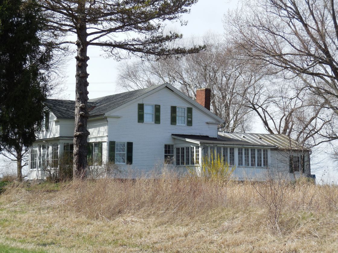
Description: The original proprietors were David Abbott (1766 – 1822) and Mary (Brown) Abbott (1770 – 1849) from Worcester County, Massachusetts. They had at least 4 children and purchased 1,800 acres of farmland which stretched on both sides of the Huron River. The Abbotts built the first wood frame barn and house in the township in 1810. David served in several public offices in the township and county and also served in the state legislature. He began construction of the Abbott – Page house in 1820. It was completed in 1824 by a son of David and Mary, Benjamin W. Abbott (1787 – 1854). The house was added to the National Register of Historic Places in 1975. Jared Ward (1767 – 1857) from Hampden County, Massachussetts was the next town proprietor. He purchased some land from the Abbotts just north of the GPS coordinates in 1809 and was a successful farmer. Jared was buried with relatives and other residents in Sweet Cemetery. Homer P. Page (1826 – 1897) from Franklin County, Vermont and Marion (Edison) Page (1831 – 1900) from Elgin County, Ontario, Canada purchased the Abbott house in 1861. Marion was an older sister of inventor Thomas Edison (1847 – 1931) who frequently visited the house. The former school was pinpointed on the 1863 county map and currently appears to be in excellent preserved condition. Valentine Fries (1826 – 1900) was the last proprietor and owned a ship building yard in the 1870s and 1880s along the Huron River just east of the GPS coordinates. It was pinpointed in the 1874 county atlas along with a school at the present location of Milan Friends Church. The current church structure was the last public building constructed in the town. In the late 1800s to early 1900s, the New York, Chicago, & St. Louis Railroad (Nickel Plate Rd) and the Wheeling & Lake Erie Railroad crossed paths on the east side of the Huron River a mile southeast of the GPS coordinates. David and Mary Abbott’s burial locations are unknown, but everyone else mentioned in this listing aside from Jared Ward was laid to rest with relatives in Milan Cemetery 4 miles south of the GPS coordinates on S Edison Dr in Milan.
Ashmont (Goodsell) – Vermilion Township
Post Office: 1883 – 1901
Location: 41.376173, -82.439805
on Joppa Rd at the intersection of Ashmont Rd
Remnants: old houses and farm buildings in the area
Description: Ashmont was on the New York, Chicago, & St. Louis Railroad (Nickel Plate Rd) in the late 1800s to early 1900s. The original proprietors were Benjamin N. Goodsell (1837 – 1908) and Catherine (Elson) Goodsell (1838 – 1920). They got married in 1856 and had at least 5 children. A church and a school were about 3/4 of a mile south of the GPS coordinates in the northwest corner of the intersection of Joppa Rd and Darrow Rd (Co Hwy 14). The post office name changed from Goodsell to Ashmont in 1886. Its known postmaster were Civil War Veteran Giles L. Jump (1845 – 1913) and F. C. Barnes. George M. Jenkins (1878 – 1941) ran a general store in Ashmont for 5 years. He was buried with relatives in Riverside Cemetery 6 1/2 miles southwest of the GPS coordinates on the north side of Hill Rd in Berlin Heights. Benjamin and Catherine were buried with relatives in Berlin Heights Baptist Cemetery 5 3/4 miles southwest of the GPS coordinates on the north side of E Main St in Berlin Heights.
Cooke’s Corners (Cooks Corner) (Four Corners) (North Monroeville) – Oxford Township, Erie County and Ridgefield Township, Huron County
Post Office: 1840 – 1857 and 1821 – 1879
Location: 41.287671, -82.725903
on SR 113 at the 4-way intersection of Patten Tract Rd (County Hwy 42) and Limberd Rd (Township Hwy 218) on the Erie and Huron County border
Remnants: North Monroeville (Cooke) Cemetery on the west side of SR 99 south of the GPS coordinates
Description: This current town has a few former names that need sorted out, as Cooks Corners is on the state’s historical populated places list. North Monroeville was originally called Cooke’s Corners and was named after Revolutionary War veteran Captain Asaph Cooke (1748 – 1826) and Thankful (Parker) Cooke (1745 – 1819) from New Haven County, Connecticut who were early pioneers in the area. On the south side of town in Huron County, a post office called Four Corners ran from 1821 – 1879. The first known postmaster was Israel Cook (1804 – 1854) who was buried with relatives, including Asaph and Thankful, in North Monroeville Cemetery 1/3 of a mile south of the GPS coordinates on the west side of SR 99. Civil War veteran Edward W. Cooke (1825 – 1890) was the next known postmaster and was laid to rest with relatives in McPherson Cemetery at the intersection of US 20 and SR 101 (E Maple St) in Clyde, Sandsuky County. Percival B. Salisbury (1818 – 1879) from Jefferson County, New York was the next know postmaster and was buried with relatives in Riverside Cemetery 4 1/4 miles south of the GPS coordinates at the intersection of US 20 and Norwalk St in Monroeville. H. G. Read was the last known postmaster. On the north side of town in Erie County, a post office called Cooke’s Corners ran from 1840 – 1857. It’s known postmasters were L. Vandercrock and War of 1812 veteran Elihu Parker (1794 – 1887) from Genesee County, New York. Elihu was buried with relatives 5 1/2 miles northwest of the GPS coordinates in Sandhill Cemetery at the intersection of W Mason Rd and Skadden Rd. The town was listed as Four Corners on the 1863 Erie County map. It was listed as Four Corners P.O. in the 1873 Huron County atlas and as Cooks Corners in the 1874 Erie county atlas. The name of North Monroeville was cartographically used by publication of the 1888 Bridgman’s Atlas of the State of Ohio.
Enterprise – Oxford Township
Location: 41.292627, -82.664687
on SR 113 at the intersection of Huber Rd along the Huron River
Remnants: none known
Description: Enterprise was a small farming town in the mid-1800s to early 1900s. It was platted with 48 lots and a public square on 5 streets including present-day SR 113. A school was on the north side of SR 113 just west of the GPS coordinates and was pinpointed in the 1874 county atlas. Although Enterprise lost its status of being a town, the area appears to never have been completely abandoned. A row of residences currently sits in the same spot as the ones dating back to the 1863 county map. A layout of the plat can be found on page 37 of the 1896 county atlas.
Furnace (Furnace Corners) – Vermilion Township (formerly in Huron County)
Post Office: 1833 – 1857
Location: 41.387465, -82.368302
on Darrow Rd (Co Hwy 14) between Thompson Rd (Township Hwy 73) and SR 60 (State Rd)
Remnants: none known
Description: This small iron furnace and farming town was temporarily the home of the oldest church congregation in the township which moved there in 1835. The known postmasters were James R. Ford, John Summers, and Lewis Wells. There was still a relatively dense cluster of buildings surrounding the intersection of Darrow Rd and Thompson Rd, and another one at the GPS coordinates on Darrow Rd at what was once the intersection of a road that diagonally stretched southeast to SR 60. Those building clusters were pinpointed on the 1863 county map. A school was about 1/4 of a mile east of the GPS coordinates in the southeast corner of the intersection of SR 60 and Darrow Rd.
Groton – Groton Township (formerly in Huron County)
Post Office: 1837 – 1859
Location: 41.337414, -82.830176
on SR 269 between Portland Rd (Co Rd 175) and Strecker Rd
Remnants: Deyo Cemetery 1/2 of a mile north of the GPS coordinates on the north side of Portland Rd just west of SR 269
Description: The post office and a blacksmith shop across the road were on a 388-acre farm owned by Dr. John P. Deyo (1804 – 1898) from Ulster County, New York and Sarah (Forster) Deyo (1819 – 1887) from Erie County, New York. They got married in 1836, had 7 children, and John was the town’s postmaster. His parents, William Deyo (1772 – 1838) and Elizabeth (Ketcham) Deyo (1780 – 1866), settled in the area in 1831 and purchased 1,200 acres of land. After the death of his father, John gave up his medical practice to pursue farming. John and Sarah were buried with many relatives, including their parents, and other residents in Deyo Cemetery.
Harper’s Corners (Berlin Station) (Ceylon) – Berlin Township (formerly in Huron County)
Post Office: 1858 – 1904
Location: 41.371665, -82.493625
on SR 61 (Ceylon Rd) at the intersection of South Depot St
Remnants: Peaks Cemetery about 1 mile southeast of the GPS coordinates on the north side of Darrow Rd (Co Hwy 14), old houses and farm buildings in the area
Description: Harper’s Corners is also on the state’s historical populated places list. It was the original name of Ceylon and was founded by Joseph Harper (1762 – died c. 1820) who moved to Ohio from Vermont. He had a few children with Esther (Dean) Adams (1767 – 1842). She remarried after Joseph passed away and her gravestone is still intact in Peaks Cemetery. The post office was established as Berlin station and changed to Ceylon in 1871. Its known postmasters were Samuel Weatherlow, Charles Church, George H. Walker, G. R. McConnelly, T. L. Curtis, Henry S. Miller, A. Willsley, F. W. Boehm, Thomas L. Hibblethwaite, and Frederick A. Ketchum. In the mid to late 1800s, Ceylon had a train station on the Sandusky, Dayton, & Cincinnati Railroad (later the Lake Shore & Michigan Southern Railway), a hotel, 2 stores, 2 saloons, and a saw mill.
Jay – Milan and Union Township (formerly in Huron County)
Post Office: 1839 – 1842
Location: 41.358439, -82.601237
on Huron Avery Rd (Co Hwy 123) at the intersection of E Scheid Rd (Scheid Rd)
Remnants: Scotts (Scott Union) Cemetery on the east side of Huron Avery Rd 1/3 of a mile south of the GPS coordinates
Description: Jay was a small farming and postal town. Edward S. Stow (1812 – 1871) from New York was the first known postmaster. Lyman Scott (born c. 1799) from Vermont was the last known postmaster. Edward was buried with relatives in Scotts Cemetery. Some members of the Scott family were also laid to rest there, but Lyman’s burial location is unknown.
Muscash – Margaretta Township (formerly in Huron County)
Location: 41.435450, -82.832799
on US 6 at the intersection of Wahl Rd
Remnants: former one-room schoolhouse just west of the GPS coordinates between US 6 & Wahl Rd
Description: Muscash was the site of the first religious congregation in the township and was founded by a group of Methodists. It was also a trading post for Native Americans who usually wanted cash instead of goods, hence the town name. A school was on the north side of Wahl Rd just west of the GPS coordinates in the mid-1800s. It was replaced by a newer building across the road (Margaretta Township No. 6) prior to publication of the 1874 county atlas. The school has since been converted to a private residence. Although it wasn’t pinpointed on maps, Muscash maintained its existence through the late 1800s. The most prominent families were the Barnes, Neill, and Prentice families.
New Salem (Petquotting) – Milan Township
Location: 41.337508, -82.567500
on the west side of River Rd just north of Mason Rd E along the Huron River Remnants: none known
Description: It was a Monrovian Missionaries town from 1787 – 1893 and was founded by Reverend David Zeisberger (1721 – 1808) from the Czech Republic who previously founded Lichtenau in Coshocton County. The main intention was religiously converting Native Americans to Christianity. After the Native Americans abandoned New Salem, they restarted it at the future site of the town of Milan but didn’t stay long. David was buried in Goshen (Zeisberger Memorial) Cemetery on Goshen Valley Rd SE (Township Hwy 322) in Goshen Township, Tuscarawas County.
Point Hope – Berlin Township
Location: unknown
Description: In 1860 a “Free Love” Utopian communistic village formed with 20 members who made the trip to Ohio from New England. They recruited a whopping one resident of the area and the village lasted a little less than a year. It was in or near Berlin Heights.
Prairieville – Perkins Township
Post Office: 1858 – 1861
Location: unknown
Description: The proprietors were Addison Mixter (1829 – 1890) from Massachusetts and Jane (Wolverton) Mixter (1828 – 1906) from New Jersey. They got married in Ohio and subsequently moved to Iowa, but returned to Erie County after the death of their first child. Addison and Jane built a general store in Perkins Township and Addison was the town’s postmaster. After the post office was discontinued, they moved to an 80-acre farm in Milan Township on the east side of the Huron River along River Rd (Township Hwy 126) and Addison served as the township’s real estate assessor. He died of a self-inflicted gunshot wound to the head after suffering from debilitating headaches for several years due to getting kicked by a horse. Addison and Jane had at least 8 children and were buried with relatives in Scotts (Scott Union) Cemetery on Huron – Avery Rd in Milan Township.
Prout (Prouts Station) – Oxford Township
Post Office: 1869 – 1905
Location: 41.351407, -82.700264
on W Mason Rd at the former railroad crossing between Campbell St (Township Hwy 110) and Ransom Rd
Remnants: none known
Description: The town was founded by Andrew W. Prout (1811 – 1881) from Orleans County, New York and Mary Emmeline (Carpenter) Prout (1818 – 1903). They got married in 1833 and purchased a farm on the northwest side of the GPS coordinates the following year. They didn’t move to the farm until 1837 though, and expanded it to 152 acres by publication of the 1863 county map. Andrew was shoe maker, farmer, and sold clocks. He was also a member of the Erie County Agricultural Society and the Firelands Historical Society. The track bed of the Sandusky, Mansfield & Newark Railroad (later the B&O Railroad) ran north along the eastern edge of the Prout farm and had a train station near the GPS coordinates. Although the railroad tracks are long gone, portions of the former path can still be seen on satellite maps. A one-room schoolhouse was on the south side of W Mason Rd just east of the GPS coordinates in the late 1800s to early 1900s. There was also a church on the south side of W Mason Rd about 3/4 of a mile east of the GPS coordinates. The post office name changed from Prout’s Station to Prout in 1882. Its first postmaster was the youngest son of Andrew and Mary, Albert H. Prout (1852 – 1918). Mary was next known postmaster. Katherine (Meredith) Prout (1863 – 1942), wife of Simeon C. Prout (1848 – 1929), was the last known postmaster. The Prouts were laid to rest in Sandhill Cemetery 3 1/4 miles west of the GPS coordinates at the intersection of W Mason Rd and Skadden Rd.
Ransoms – Margaretta Township, Erie County and Townsend Township, Sandusky County
Location: 41.386631, -82.845677
on Vickery Rd and Co Rd 247 at the intersection of Carson Pass (NW Rd) along Little Pickerel Creek
Remnants: none known
Description: The proprietors were Charles H. Ransom (1821 – 1901) from New London County, Connecticut and Susan (Slaughter) Ransom (1826 – 1917) from New York. They had 6 children and accumulated 764 acres of land in the area engaging in farming and stock dealing. A steam-powered saw mill and a grist mill were along Vickery Rd just west of the GPS coordinates in the mid to late 1800s. The Sandusky, Dayton, & Cincinnati, Railroad (later the Lake Erie & Western Railroad) rolled through the southeast corner of the Ransom farm in Margaretta Township. Charles and Susan were buried with relatives in Oakland (Sandusky) Cemetery on US 250 (Milan Rd) in Perkins Township.
Shattucks Grove (Shaddock’s Grove) (Shaddock’s Lake Park) (Crystal Beach Park) – City of Vermilion (formerly in Vermilion Township)
Location: 41.425020, -82.347890
on the north side of US 6 (Liberty Ave) between Nantucket Pl and Salem Dr
Remnants: none known
Description: It was a summer vacation resort village next to Lake Erie owned by George M. Shaddock (or Shattuck). The venue hosted traveling circuses, dances, picnics, and other family oriented events in the late 1800s to early 1900s. George H. Blanchat (1875 – 1938) from Wayne County and Josephine (Lesher) Blanchat (1879 – 1952) got married in 1901 and opened Crystal Beach Amusement Park at the location in 1907. Their family continued to operate the park until it closed in 1962. The amusement park never charged for admission or parking. Visitors only paid for the rides, games, and refreshments they wanted. They were also allowed to bring in their own food and beverages. Among the many attractions were a roller coaster, skating pavilion, and a ballroom that could accommodate up to 2,000 dancers. Some famous musicians and singers occasionally entertained the guests. George and Josephine were buried with relatives in Calvary Cemetery on N Ridge Rd in the City of Lorain in Lorain County. Linwood Park was another summer resort community just to the west of Shattucks Grove. They can both be spotted on page 7 of the 1896 county atlas.
Spragues Corners – Florence Township (formerly in Huron County)
Location: 41.305785, -82.413337
on Florence Wakeman Rd at the intersection of Harmon Rd (Township Hwy 19)
Remnants: none known
Description: The town was founded by Ezra Sprague (1785 – 1856) from Berkshire County, Massachusetts and Harriet (Griswold) Sprague (1782 – 1852) from Connecticut. They got married in Ohio in 1807, were the first settlers in the township in 1809, and had 7 children. Ezra was the first justice of the peace and a common pleas court judge. The family owned about 600 acres of land in the area by publication of the 1863 county map. A school was about 1/4 of a mile south of the GPS coordinates on the west side of Florence Wakeman Rd and was pinpointed in the 1874 and 1896 county atlases. Florence (formerly Florence Corners) a little over a mile to the north became the commercial center of the area in the mid-1800s and Spragues Corners fell into obscurity by 1900. As seen in other places around the state though, the residents of Spragues Corners may have been perfectly content with that, enjoying more elbow room and much less crossroads traffic. Ezra and Harriet were buried with relatives 1 3/4 miles west of the GPS coordinates in Cable Cemetery on the east side of Cable Rd (Township Hwy 59) just south of Harmon Rd.
Yankee Settlement – Perkins Township (formerly in Huron County)
Location: 41.384981, -82.667298
on Taylor Rd at the intersection of Columbus Ave along Plum Brook
Remnants: Perkins Cemetery 1 1/2 miles northeast of the GPS coordinates on Beatty Ln off of US 250 (Milan Rd)
Description: Irish immigrants Reverend John Beatty (1774 – 1845) and Mary (Cooke) Beatty (1776 – 1852) purchased most of Perkins Township from the Firelands Company and moved their family there with a group of settlers shortly after the War of 1812 ended. Some of the other settlers were Joseph Taylor, Jesse Taylor, Julius House, Holly Akins, Roswell Hubbard, Harvey Covell, Eleazer Bell, Plinney Johnson, Richard Christopher, and William Beebe. A couple of decades later, John Beatty beacame the mayor of Sandusky from 1834 – 1836. In the late 1800s to early 1900s there was a church on the north side of the intersection and a school on the south side of the intersection. Many of the pioneers and their descendants were buried in Perkins Cemetery. John and Mary were laid to rest with relatives in Oakland (Sandusky) Cemetery 4 miles north of the GPS coordinates on US 250.

Erie County, Ohio Ghost Towns Research Resources
1863 – Erie County map
1874 – Erie County atlas
1896 – Erie County atlas
1879 – History of the Fire Lands, Comprising Huron and Erie Counties, Ohio
1889 – History of Erie County, Ohio
1916 – A Standard History of Erie County, Ohio – Vol. 1
1916 – A Standard History of Erie County, Ohio – Vol. 2
